

-
 47438 Hits
-
 87.76% Score
-
 25 Votes
|
|
Area/Range |
|---|---|
|
|
44.04466°N / 10.31026°E |
|
|
Hiking, Mountaineering, Trad Climbing, Sport Climbing, Scrambling, Via Ferrata, Canyoneering, Skiing |
|
|
Spring, Summer, Fall, Winter |
|
|
6388 ft / 1947 m |
|
|
1 - Overview
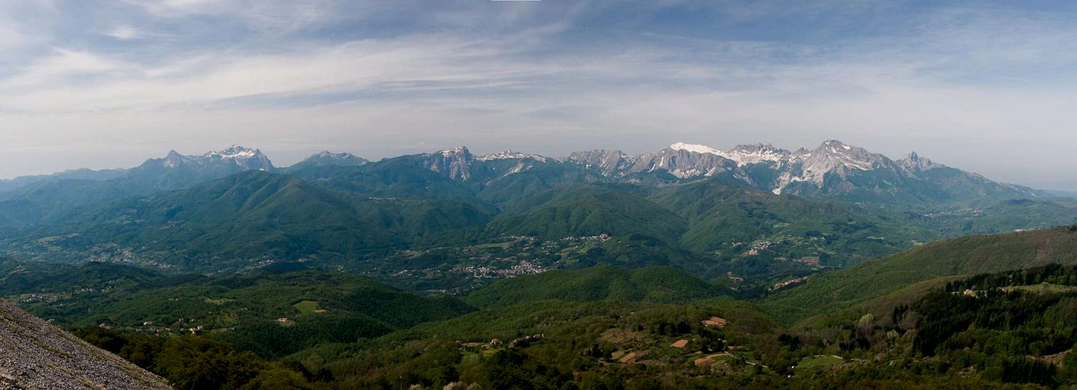
 Apuane main ridge as seen from Monte Sagro Apuane main ridge as seen from Monte Sagro |
Most visitors to Italy's Toscana / Tuscany don't know that region contains two mountain ranges, both of which rise to about or more than 2000m. To the east – along the border to Emilia Romagna - you will find the omnipresent Appennino, Italy's backbone which reaches all the way down to the southernmost part of the peninsula. To the north-west, on the other hand, there is a small but wild coastal mounatin range, the Alpi Apuane (Apuane Alps) or in short the Apuane. It stretches from the well known city of Lucca in the south to the marble quarries of Massa and Carrara in the north. The western boundary is the Tyrrhenian Sea while the eastern one is the valley of the Serchio River, the region of Garfagnana.
The Alpi Apuane are one of the most original relief areas in Italy, for the variety of landscape, environment and location. It cannot be considered as a part of the Appennini range but stands on its own close to the Tyrrhenian Sea. In fact within a few kilometers, starting from the coastal plain in Versilia (W), Lunigiana (N) and Garfagnana (E) the Apuane rise to reach almost 2.000m of altitude with Monte Pisanino (1947m).
This orographic complex is called "Alps" because of its massive mountains, steep morphology, imposing and very inclined slopes, great walls and deep valleys which make the range more similar to the Alps then to the Appennini: for example the Pizzo d'Uccello north face (1781m), with his 800m of difference in elevation, can be compared with Dolomite or Western Alps walls. Though the elevation of these mountains is less than 2000m, the steepness of the faces as well as the sharp ridges made them interesting from a mountaineering point of view.
  |
The mountain range is made up from all kinds of limestone – brittle and karst-like in the south, solid and dolomite-like in the centre, impressive with huge marble enclosures in the north and west. Consequently the Alpi Apuane – though restricted to a small area – offer a wide range of aspects and activities. The range has been protected by a natural park, the Parco Naturale delle Alpi Apuane, established mainly to protect flora and fauna but also restricting marble prospecting in the area.
 Marble Quarries
Marble has been the main source of income in the area for ages. Carrara and marble have become synonyms and some of the world's highest quality marble is found in Carrara's back country, the Alpi Apuane. Marble has been quarried since Roman times and the name of Carrara has its origins in the Celtic name for quarry. Michelangelo established quarries in the north face of Monte Altissimo and today you can count more than 300 marble works. Those, however are more or less restricted to the north and west of the range and most of them have been abandoned. These old quaries still contain huge amounts of marble but it doesn't meet the quality reserved for Carrara marble. In the end – while the Alpi Apuane are a wonderful hiking and climbing range you have to take care to be in the right place at the right time. On week days the activity in the marble works can be very loud and lorries transporting the marble blocks down to the valleys can be serious obstacles on the narrow and winding mountain roads.
2 - Main Areas of the Range
 Overview Map of the Alpi Apuane
The Alpi Apuane stretch for 65 km beside the Tyrrhenian Sea coastline from NW to SE. The range is set within the limits of three different regions:
- Lunigiana in the north with the Magra and Aulella Rivers
- Versilia in the west and south
- Garfagnana to the east with the Serchio River
The range can be divided into four areas from a geographical point of view:
- North-western sector: Pisanino Group, Vinca and Carrara Apuane
- Western sector: Massa and Arni Apuane
- Eastern sector: Panie Group
- Southern sector: Stazzema Apuane
3 - Apuane North-Western Sector
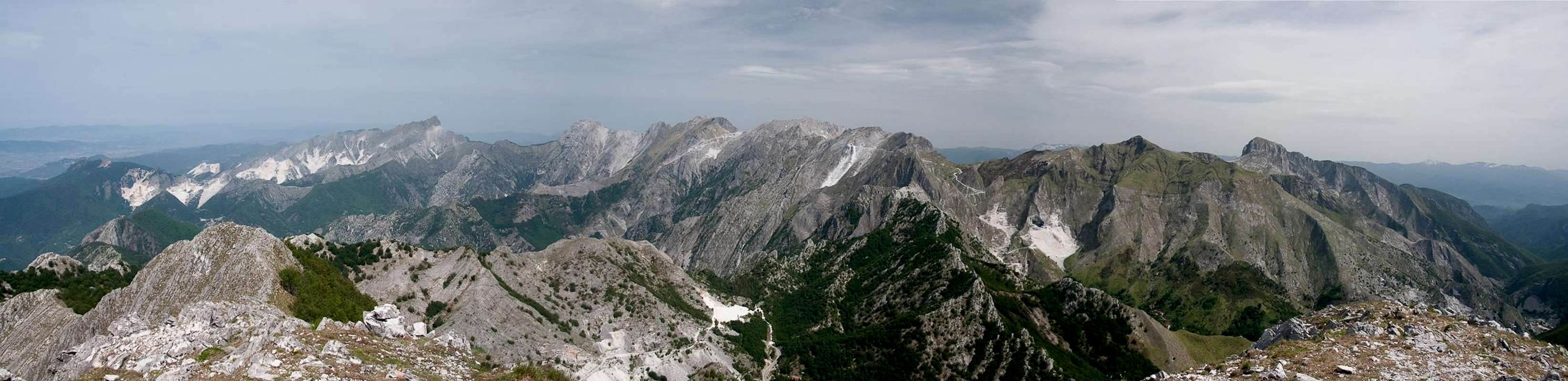 |
The north-western sector of the Alpi Apuane is the most important part of the whole range. Here you can find the three highest mountains: Monte Pisanino (1947m), Monte Tambura (1894m) and Monte Cavallo (1889m). Also, the most alpinistic mountain, Pizzo d'Ucello is part of this sector, standing aside to the north and connected to the main ridge by the Garnerone Ridge. Pizzo d'Ucello also is home to the most important rock climbing route, the Via Oppio Colnaghi. Thanks to Gabriele we have a number of links about the route in the "External Links" section at the bottom of this page.
Since the north-western sector is the backcountry of Carrara you'll find marble quarries everywhere. Therefore most activities are restricted to the weekend, when access along the narrow mountain roads is not disturbed by the huge lorries which carry the heavy marble blocks. The biggest set of quarries is to the north-east of Carrara, where a whole mountain has fallen victim to the works. The highest quarry is at Passo della Focolaccia at 1660m, right between Monte Cavallo and Monte Tambura. The most impressive quarry is high in the west face of Alto di Sella. The Cave Cruze are abandoned but there still is the Via di Lizza, a path, along which the huge marble blocks were moved down on round logs.
To the east of this sector there is Monte Sumbra. Located just across Val Turrite Secca from Pania della Croce, Monte Sumbra contains vertical walls on all sides but one, where the (blunt) knife edge east ridge offers a panoramic, but severely exposed easy access to the mountain. Monte Sumbra's south face drops vertically for 700m and is one of the most impressive sights of the range. As it stands aside from the remainder of the northern Apuane, Monte Sumbra also is a wonderful lookout peak.
- Monte Volsci (1268m)
- Monte Ucelliera (1013m)
- Monte Ciutella (968m)
- Monte Castellaccio (843m)
- Monte Salloniana (1133m)
- Monte la Cima (1268m)
- Monte Grotti (1333m)
- Monte Sumbra (1765m)
- Monte Fiocca (1708m)
- Monte Croce (1532m)
- Monte Macina (1566m)
3.2 - Tambura / Sella
- Monte Sella (1735m)
- Alto di Sella (1726m)
- Monte Focioletta (1643m)
- Monte Tambura (1894m)
- Monte Roccandagia (1717m)
- Monte Tombaccia (1371m)
- Monte Tontorone (1100m)
- Monte di Roggio (1073m)
- Monte Corona (1098m)
- Monte Umbriana (1229m)
- Monte Forconi (1081m)
- Monte Casatico (1008m)
3.3 - Pisanino / Cavallo / Ucello
- Monte Rocchetta (1064m)
- Monte Coccuruzzolo (961m)
- Monte Calmaio (1040m)
- Monte Castri (1013m)
- Monte Mirandola (1566m)
- La Forbice (1680m)
- Bagola Blanca (1801m)
- Monte Pisanino (1947m)
- Pizzo Maggiore (1794m)
- Pizzo Altare (1747m)
- Monte Cavallo (1888m)
- Monte Contrario (1790m)
- Il Pizzone (134m)
- Punta Questa (1522m)
- Tre Figari (1511m)
- Monte Grondilice (1805m)
- Pizzo d'Ucello (1781m)
- Punta la Nattapiana (1403m)
- Pizzo dell'Aquila (1253m)
- Monte San Giorgio (940m)
3.4 - Rasori / Sagro / Burla
- Monte Rasori (1472m)
- Monte Sagro (1749m)
- Monte Spallone (1636m)
- Cima delle Serre (1274m)
- Monte la Faggiola (1453m)
- Monte Maggiore (1390m)
- Il Torrione (895m)
- Monte Betogli (704m)
- Monte Borla (1465m)
- Torre di Monzone (1208m)
- Monte Ballerino (1387m)
- Monte Ucceliera (1247m)
- Monte Pesaro (862m)
- Zucco dell'Urlo (981m)
- Monte Puntone (818m)
- Monte la Piazza (950m)
- Monte la Pianaccia (810m)
- Monte Pizzacuto (810m)
3.1 - Sumbra / Fiocca
4 - Apuane Western Sector
 The western sector of the Alpi Apuane as seen from Monte Sumbra
The western sector of the Alpi Apuane surrounds the town of Massa with its marble quarries. The northern boundary is the valley of Colonnata, the southern one the valley of the river Vezza. The eastern boundary is Passo Croce, which separates the subgroup from the Pania della Croce Group. The highest mountain of the group an most alpinistic feat is Monte Altissimo at 1589m. The mmountain has a 700m vertical south-west face, into which the first quarries were established by Michelangelo himself. Most of the marble works of this sector have been abandoned but also some of the biggest ones remain operative. Rock is brittle, which is most evident near Passo del Vestito where a whole ridge of limestone towers stays sentinel above the pass.
- Monte Castellaccio (810m)
- Monte Cavallo (1021m)
- Monte Cipollaio (1107m)
- Monte dei Ronchi (1354m)
- Monte delle Tavole (1483m)
- Monte Altissimo (1589m)
- Monte Pelato (1325m)
- Monte Antona (903m)
- Monte Belvedere (894m)
- Monte Focoraccia (1147m)
- Monte Carchio (1078m)
- Monte Folgorito (911m)
- Monte Rotondo (700m)
- Monte Canala (432m)
- Pietra Bianca (701m)
- Monte Brugiana (964m)
- Monte Zuccone (713m)
- Cima la Giola (864m)
5 - Apuane Eastern Sector
 |
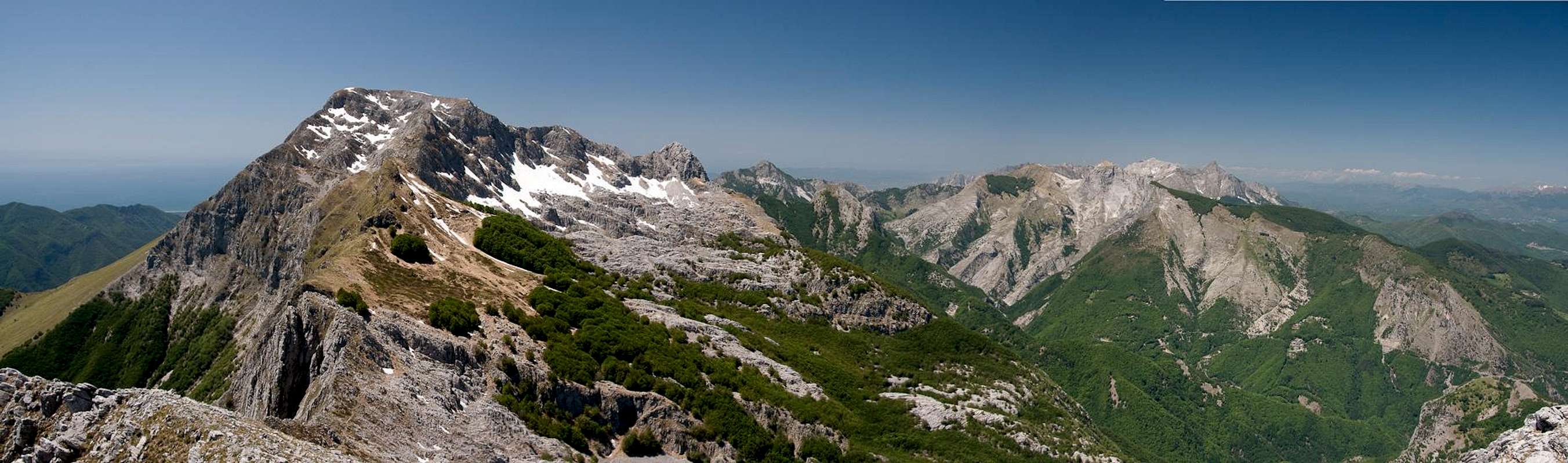
Pania della Croce, together with its neighbours Uomo Morto and Pania Secca is the trademark mountain of the Alpi Apuane though it is only number four in height. It stands as a barrier between the northern and southern sectors of the range, rising for more than 1000m out of the profound valleys of Torente Turrite Secca in the north and Torente Turrite di Gallicano in the south. The western boundary is Passo Croce while the eastern boundary reaaches all the way to Gallicano on the Serchio River. Pania della Croce easily is one of the most popular mountains of the group, thanks to its central location and the fact that several hiking routes lead to its summit. Both Pania della Croce and Pania Secca are among the best lookout summits of the Alpi Apuane.
The mountains themselves as well as the karst plateau in between are a sanctuary for a herd of Mufflons which, reclusive as they are can seen grazing on the steep slopes and faces of the subgroup. There is no marble quarrying or prospecting on the Panie but nearby Monte Corchia is one of the most damaged mountains of the whole range. It has quarries all over its west face, up to the very summit.
- Promonte (490m)
- Monte Faeto (498m)
- Monte d'Anima (898m)
- Grottorotondo (1068m)
- I Campanili (868m)
- Le Rocchette (1117m)
- Monte Piglionico (1145m)
- Monte di Gesu (1137m)
- Monte Rovaio (1057m)
- Pania Secca (1708m)
- Uomo Morto (1665m)
- Pania dela Croce (1859m)
- Pizzo delle Saette (1720m)
- Monte Celo (1084m)
- Monte Corchia (1678m)
- Guglie del Corchia (1632m)
- Monte Freddone (1480m)
- Cima Costa della Mura (1342m)
- Cima Gofognalia (930m)
6 - Apuane Southern Sector
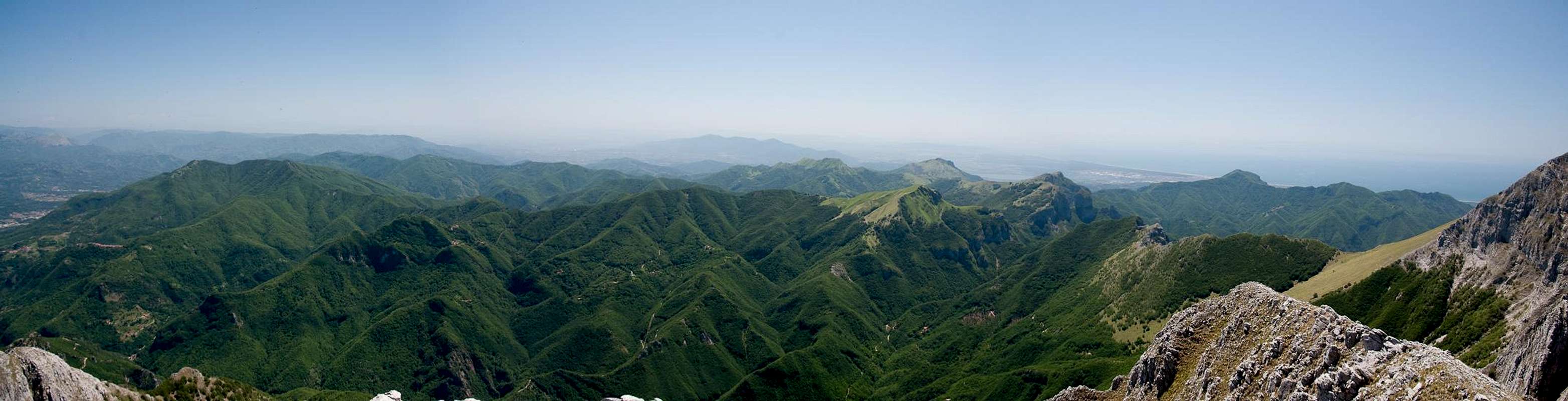 |
The southern Alpi Apuane are the lowest part of the region. The main summits barely reach more than 1300m and most are covered by trees. Here you can witness the whole variety of karst formations. This is most obvious near Monte Nona, beside which the tower of Monte Procinto stands like a sentinel above the valley of Stazzema. Close by, between the two summits of Monte Forato, there is a huge arch, witness to the effects of erosion on limestone. Also – some of the biggest caves of Italy (and Europe) can be found within the Alpi Apuane. The most famous one is Grotta del Vento at the base of Pania Secca.
The most important summit of this sector are located in its north near the village of Stazzema. However, the region is quite large and a large number of lesser summits can be found in the south and east. Most important ar Monte Piglione with its multiple summits, Monte di Prana and the two ridges which rise north and south of Fabbriche di Vallico. The highest mountain of the whole subgroup is Monte Matanna south-east of Stazzema.
- Monte Rondinaio (740m)
- Monte Pedone (1013m)
- Monte di Prana (1221m)
- Monte Riglione (586m)
- Monte Penna (494m)
- Monte Ciurlaglia (852m)
- Monte Piglione Nord (1231m)
- Monte Piglione Sud (1184m)
6.2 - Pescaglia
- Monte Poraglio (1027m)
- Monte Cuculiera (933m)
- Monte Caciarli (982m)
- Monte Botronaccio (976m)
- Monte Rosso (689m)
- Cima Carici (959m)
- Il Forte (846m)
- Monte Bargiglio (874m)
- Monte Agliale (757m)
- Monte Bborti (806m)
6.3 - Fabbrice di Vallicio
- Monte Penna (990m)
- Monte Palodina (1170m)
- Monte Gagno (968m)
- Montaprato (1088m)
- Monte Albano (931m)
- Tre Corna (1057m)
- Monte Bicocca (1036m)
6.4 - Stazzema
- Monte Colegno (536m)
- Monte Bacci (589m)
- Monte Anchiana (728m)
- Monte Costa (564m)
- Castellacio (631m)
- Monte Ornato (662m)
- Monte Lieto (1018m)
- Monte Gabberi (1109m)
- Monte Gevoli (951m)
- Monte di Croce (888m)
- Monte Matanna (1318m)
- Monte Nona (12997m)
- Monte Procinto (1147m)
- Monte Croce (1314m)
- Monte Forato (1223m)
- Penna Rossa (813m)
- Sullioni (1001m)
- Mont'Alto (913m)
6.1 - Camaiore
7 - Getting There
 |
The two closest airports are at Pisa and Firenze (Florence). Both cities are connected with each other by motorway A11; the drive takes about 45 minutes. The best starting point is Castelnuovo di Garfagnana, a town to the east of the range, which also serves as base for the mountains of the Appennino. A winding mountain road through the Apuane connects Castelnuovo with Massa and Seravezza in the west.
Western access: Take the coastal motorway A12 from Pisa or Lucca. It will take you to the western base of the mountains.
Eastern Access: From Lucca Take SS12 to Bagni di Lucca. There switch to SS445 into Garfagnana.
8 - Red Tape
 Narcissus poeticus
The Parco Naturale delle Alpi Apuane was established in 1985 to protect the nature as well as culture of the area within which the Alpi Apuane are located. Its overall size amounts to almos 21000 ha. A constant challenge is the presence of roughly 300 marble quarries which their impact on the environment. A hiker might easily find himself inside one of the quarries and is requested to follow signs and rules there.
The park's official website
9 - Accommodation / Mountain Huts
9.1 - Accommodation
Accommodation is relatively easy to find along the coast of the Tyrrhenean Sea. Viareggio, Massa, Carrara and La Spezia offer lots of hotel rooms as well as campgrounds. Either book them by travel office or go for a google search.
On the other hand, to stay closer or within the range you can make use of Agriturismo, farms, which offer food and lodging. The site of the Natural Park has a selection of all kinds of accommodation of the area:
9.2 - Mountain Huts
| Name | Elevation | Telephone |
| Rifugio Capanna Garnerone | 1260m | +39 0585 776782 |
| Rifugio Carrara | 1320m | +39 0585 841972 |
| Rifugio Orto di Donna | 1496m | +39 347 3663542 / +39 349 1424641 |
| Rifugio Val Serenaia | 1100m | +39 347 3663542 / +39 349 1424641 |
| Rifugio G. Donegani | 1150m | +39 340 1509327 / +39 348 6520820 |
| Rifugio Conti | 1442m | +39 0585 793059 |
| Rifugio G. del Freo | 1180m | +39 0584 778007 |
| Rifugio E. Rossialla Pania | 1609m | +39 0583.710386 / +39 0583 74095 / +39 348 3898003 |
| Rifugio Pian dei Molini | n.a. | +39 0583 661275 |
| Rifugi il Robbio e la Quiete | 995m | +39 0585 45440 / +39 338 9350953 |
| Rifugio la Fania | 900m | +39 0584 769545 |
| Rifugio lo Scoiattolo | n.a. | +39 0583 764770 |
| Rifugio Forte dei Marmi | 865m | +39 / 0187 715116 / +39 338 8284628 |
| Rifugio la Buca | 480m | +39 0583 722013 |
| Bivacco Aronte | 1620m | +39 0585.488081 |
| Bivacco K2 | 1500m | +39 0585 776782 |
| Posto Tappa Caprichia | 817m | +39 0583 65169 |
| Baita Delio Barsi | 800m | +39 0584 989870 |
| Bar Ristoro Alto Matanna | 1030m | +39 0584 776005 |
| Albergo le Alpi | 679m | ++39 0583 664057 |
| Rifugio Alpe San Antonio | 825m | +39 0583 65169 |
| Rifugio Puliti | 1016m | +39 0584 789113 / +39 0584 70563 |
10 - Weather Conditions
11 - Maps & Books
11.1 - Maps
- Alpi Apuane - Garfagnana
Kompass Verlag
1:50000
ISBN: 3-85491-852-6
- Geological Map Parco delle Alpi Apuane
1:50000
L. Carmignani, P. Conti, L. Disperati, P.L. Fantozzi, G. Giglia and M. Meccheri
11.2 - Maps Online
11.3 - Books
- Tuscany North / Toskana Nord
Wolfgang Heitzmann / Renate Gabriel (translation: Gill Round)
Rother Verlag
ISBN: 978-3-7633-4812-1 (English)
ISBN: 978-3-7633-4115-3 (German)
- Guida al Parco delle Alpi Apuane
Edited by: Giuliano Valdes
Series: Guide Felici
ISBN: 88-88327-91-6
- Guida all’Alta Via del Parco delle Alpi Apuane
Angelo Nerli
Felici Editore Srl
ISBN: 88-6019-006-1
External Links
Alpi ApuaneParco Naturale delle Alpi Apuane
The following three links show detailed information about the Via Oppio-Colnaghi, the most important route in the range on Pizzo d'Ucello
- http://www.sassbaloss.com/pagine/uscite/pizzouccello3/pizzouccello3.htm
http://www.ufficioguide.com/alberto/OPPIO-sito/index02.htm
http://scuolaguidodellatorre.interfree.it/relazioni/roccia/PizzoUccello-viaOppioColnaghi.html