The name Babia Góra (Polish) or Babia hora (Slovak), which can be translated as Old Women's/Witches' Mountain, or just Babia for short, can be used to refer to the following entities:
the massif that extends from the saddle named Jałowiecka Przełęcz Południowa in the west to Krowiarki pass in the east and has two prominent peaks – Babia Góra/hora at 1725 m and Mała/Malá (Little) Babia Góra/hora (in Poland also known as Cyl) at 1517 m, separated by Brona/Brána saddle at 1408 m
the part of the massif east of Brona/Brána saddle, i.e. without Little Babia
the highest summit of the massif
Poles also call the highest summit Diablak. Similarly, it used to be called Teufelspitze by Germans/Austrians. Both names mean Devil's Peak. There are several legends about the mountain, most of which feature a devil as one of the characters. This may be a reflection of the fickle, usually very windy, sometimes treacherous and/or really fiendish weather on the summit. For the same reason, Babia Góra is also called the 'Mother of bad weather' by the locals.
Babia Góra - beautiful and capricious, often referred to as the 'Queen of the Beskids' - was already mentioned in late-medieval chronicles. According to some old legends Babia Góra is a sitting old woman ('baba') turned into stone, or a huge heap of rubbish raised by women visiting a nearby sanctuary. Babia's summit was famous among local people for centuries as a place where witches had their Sabbaths.
Overview
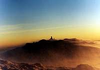
Babia Góra seen from the Tatras
The huge, around ten kilometers long, formed mostly of exceptionally hard sandstone massif of Babia Góra straddles the Poland-Slovakia border some forty kilometers northwest of the Tatras. It totally dominates its surroundings and makes the Beskid Żywiecki range (in Slovakia known as Oravské Beskydy: Please see here) the second highest mountain range in Poland and the highest range in all of the Western Beskids (the Flysch belt of the Northwestern Carpathians). Babia Góra has 1071 m of prominence, thus being the second most prominent summit in Poland and third in Slovakia.
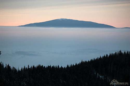
Babia Góra massif seen from NE
Babia Góra massif is asymmetric in shape - its south side is gentle whereas its north side is very steep, occasionally cliffy. The main ridge of the massif extends from Jałowiecka Przełęcz Południowa (a pass at 997 m) in the west to Krowiarki pass (1012 m) in the east, forming an arc convex towards the south. Near the center and the southernmost point of the ridge is its main summit, Diablak at 1725 m. East of it sit the following - far from prominent - summits: Gówniak at 1617 m, Kępa at 1530 m and Sokolica (whose characteristic, cliffy north face is a scarp of a landslide) at 1367 m. To the west of Diablak sits a shallow saddle called Lodowa Przełęcz at 1608m, past which stretches the flattish ridge of Kościółki, which reaches 1620 m, then descends to Brona/Brána saddle at 1408 m, beyond which rises the peak of Little Babia (1517 m).
Babia seen from Brona/Brána saddle (on the right rises the ridge of Kościółki)
Along the western crest of Babia Góra massif runs the Poland-Slovakia border, which takes a sharp turn at Diablak summit to descend the south side of the mountain. Babia Góra may have been glaciated in the Ice Age, but since its end (and surely before its beginning as well) has been shaped by landslides which destroyed most, if not all, traces of glaciers. Scarps at landslide heads, bulging bulk of displaced rock material and tiny lakes inside hollows within landslide toes dot the northern side of the massif.
The northern slopes with Little Babia in the background
Summit Area & Views
The summit area rises a couple of hundred meters above the tree line, which runs at approximately 1400 m. Higher up stretches the realm of dwarf mountain pine (Pinus mugo), which was devastated a few centuries ago in order to extend mountain pastures and graze herds of oxen, but is now fighting back. On and around the very summit are talus, some bare rock and alpine meadows. There are also a couple of man-made structures, relatively small in size, such as two rather unsightly monuments (to Archduke Joseph and to Pope John Paul II). However, the biggest structure erected by humans on the summit of Babia Góra is a two meter high wall of stone, which protects hikers from the notorious winds. At the north side of this wall is an inscription carved in situ in 1924, which has sentimental value for many Poles.
Diablak seen from above Brona/Brána saddle
Views from the summit are overwhelming. In fact, for some they are the main reason for an ascent of Babia Góra. Quite a few people keep summiting before sunrise, but the best views, especially of the Tatras, can be admired an hour before sunset. The southerly, most interesting panorama encompasses the following mountain ranges: High Tatras, Western Tatras, Chočské vrchy, Veľká Fatra and Malá Fatra. Looking west-southwest Pilsko and Romanka come into sight and just west of Babia rises Little Babia. To the north and east stretch many lower ranges and ridges of the Western Beskids, of which the highest is Polica at 1369 m about nine kilometers to the northeast.
Some of the photographs featured below were taken a bit off the summit, but the scene they show does not differ much from what is seen from the very top.
Getting There & Routes
Many people start an ascent of Babia Gora in the village of Zawoja, the longest village in Poland extending for 18 km along the valley of Skawica creek. Zawoja is easily accessible from Kraków (Cracow) by car or bus, or rather minibus. The minibuses/buses depart from the station located just outside Cracow Central Railway Station. The ticket costs up to 18 zlotys (about 4 euros), the journey takes two hours. Usually, you have to get off at Zawoja-Widły, but if you are lucky your minibus will take you 3.5 km further south, to the entrance to the national park at Zawoja-Markowa.
Babia Góra from Markowa
The bad step
The bad step
Perć Akademików
Trail from Krowiarki pass
However, those travelling by car most often choose Krowiarki pass on Road 957 as a start point. The most interesting stretch of all routes is undoubtedly Perć Akademików, which climbs the steep, north side of Babia. It is the rockiest waymarked path in all of the Flysch Carpathians, which boasts a few chain-assisted sections, including an eight meters high 'bad step' fitted with steel rungs. The table below lists the shortest, most popular routes to the summit of Babia Góra.
Ascent from the
Start point
Approx. total elevation gain
Approx. length of hike
Time for walk up
Marks
North
Zawoja-Markowa
1025 m
6.3 km
2 hr 40 min
green-red (via Brona/Brana pass)
North
Zawoja-Markowa
1025 m
5.7 km
2 hr 50 min
green-yellow (via Perć Akademików)
East
Krowiarki pass
715 m
4.5 km
1 hr 50 min
red (via east ridge)
South-West
Oravská Polhora
1080 m
10.7 km
3 hr 30 min
red-yellow (via Slaná voda)
In Slovakia, the usual trail head is in the village of Oravská Polhora sitting on Road 78 that traverses the northernmost peninsula of the Slovak territory. At a hamlet of Oravská Polhora, Slaná voda (once a popular spa), begins an interpretive trail to the summit. It has several shelters and a viewing tower (at 1190 m). You can return via Malá Babia hora (red marks) turning your hike into a neat circuit.
The Polish part of the massif is the Babia Góra National Park, part of the World Network of Biosphere Reserves. Camping, bivouacking, off-trail hiking and dogs are not permitted. You have to pay an entry fee, which in 2023 was 8 zlotys (less than 2 euros): tickets online. On Perć Akademików (see chapter 4) only upslope traffic is allowed. (The rule seems to make sense in summer, when traffic can be heavy.) The trail is closed in winter due to avalanche risk. The Slovak part of the massif is a nature reserve, in which the regulations are as strict as in the Polish territory. No entry fee is collected.
Accommodation
Markowe Szczawiny hut
Former hut
The first mountain hut on Babia Góra was built by Beskidenverein in 1905, when Poland was occupied by Austria. It stood about 300 m southeast of the summit by a spring called Głodna Woda, but burnt a few years after World War II. The first Polish hut was built at 1180 m northwest of the summit, at a clearing called Markowe Szczawiny, just a year after the Beskidenverein hut. It lasted over a hundred years and in 2009 was replaced by a modern building. Markowe Szczawiny hut is very popular with individual hikers and school groups, even in the off season. If the hut is fully booked, you can get a place on the floor, which in 2017 cost about €6. The Polish village of Zawoja at the north foot of Babia Góra offers a wide range of accommodation, which in contrast is rather limited in the Slovak village of Oravská Polhora, which has a few guesthouses and Slaná Voda hut at 750 m.
Zawoja from Brona saddle
Over six kilometers northwest of the summit of Babia, just north of the crest of Mędralova/Modrálová (1169 m), outside the national park, sits a shelter which used to be a shepherd hut. Lastly, on the Slaná Voda – Babia Hora trail there are several newly-built shelters, but bear in mind that bivouacking is not allowed there (see chapters 4 and 5).
When To Climb, Rescue & Weather
You can climb Babia Gora all year round. In July t-storms and fog are common. The best time, when you can count on relatively long spells of good weather and excellent views, seems to be August to October, but in August (and July) huge crowds are the norm.
Mountain rescue team's phone number: Poland (GOPR) (+48) 601 100 300 or 985 Slovakia (HZS) (+421) 18 300 Warning: In Slovakia - unlike in Poland - those who do not carry commercial insurance have to pay for any rescue services rendered by Mountain Rescue Service (HZS).
Children refers to the set of objects that logically fall under a given object. For example, the
Aconcagua mountain page is a child of the 'Aconcagua Group' and the 'Seven Summits.' The
Aconcagua mountain itself has many routes, photos, and trip reports as children.
Parents refers to a larger category under which an object falls. For example, theAconcagua mountain page has the 'Aconcagua Group' and the 'Seven Summits' asparents and is a parent itself to many routes, photos, and Trip Reports.


 37557 Hits
 96.97% Score
 64 Votes
 Babia Góra seen from the Tatras
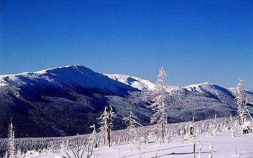 Babia Góra massif seen from NE
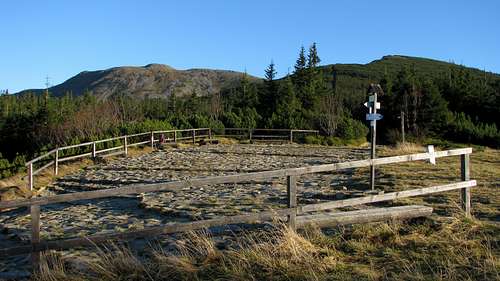 Babia seen from Brona/Brána saddle (on the right rises the ridge of Kościółki)
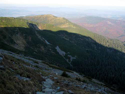 The northern slopes with Little Babia in the background
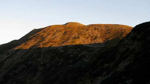 Diablak seen from above Brona/Brána saddle
")

")


 Babia Góra from Markowa
 The bad step
 The bad step
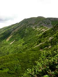 Perć Akademików
 Trail from Krowiarki pass
 Babia hora massif from S
 Nearing Malá Babia's summit
 2nd highest shelter
 Highest shelter

 Markowe Szczawiny hut
 Former hut
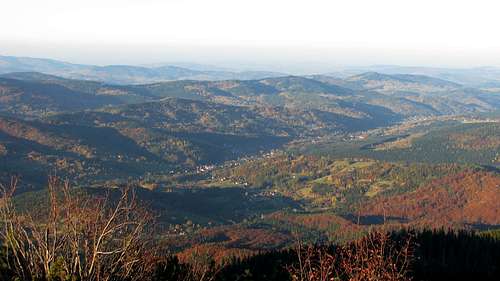

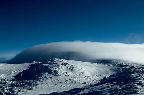 29 December 2008 - photo by stjepan