DID WHYMPER MAKE ONLY THE BARRE DES ECRINS SECOND ASCENT ?
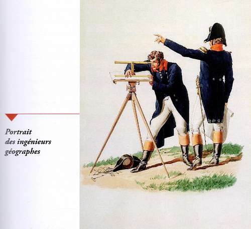
For the 150th anniversary of the first ascent by Edward Whymper of the Barre des Écrins (25th June 1864) a new theory appeared attributing it to Lieutenant Meusnier who would have climbed it in 1853! Meusnier was one of the French army cartographers who in 1853 were in charge of mapping the Briançon area.
This theory is based on a digitized document published by the IGN (Institut Géographique National) in 2012. It is a draft of the 1/40000 Briançon map mentioning a ‘Signal’ besides the name ‘Les Écrins’, summit which is then the highest in France (until the 1860 Turin treaty which sealed the annexation of Savoy by France).
This mention let two individuals from Vallouise, Joseph Olivier and Paul-Billon Grand pretend that the summit had been climbed then by the French military cartographer 11 years before Whymper and his companions (June 25th 1864).
They then attempted to present this discovery as a ‘revolution’ in the history of alpinism, and to top it they associated themselves with a cartographer, Alexandre Nicolas and an Italian, Eugenio Caroglio (CeSRAMP – University of Torino) questioning as well many other first ascents in the Écrins and the Viso areas, namely by Francis Fox Tuckett, Williams Matthews and Williams Augustus Brevoort Coolidge.
Olivier and his henchmen made a significant number of conferences spreading their ‘revolutionary’ discovery, questioning the work done up to now by the historians specialists of the subject and as well as by the French and British Alpine Clubs, accusing them to have written a biased history within a small group and to their own benefit.
This so-called ‘discovery’ was widely spread by publication in the press and on social networks.
At one of those conferences in Vallouise on the 15th of August 2016, a representative of the AC was present and Olivier-Joseph mentioned in his August Internet publication the following: “As far as Sue Hare, Alpine Club secretary, was concerned, she did not hide her enthusiasm at the end of our conference.” Sue was and is not the AC secretary and was surprised and certainly not so enthusiastic then, but anything which could be used to comfort their ‘discovery’ and particularly when coming from the AC - the most guilty party of the plot - was obviously worth taking.
My friend Claude Deck (GHM-CAF) who did run La Montagne et Alpinisme’s alpine chronicle for some 40 years until 2016 was the first to react, asking me to contact the Alpine Club in order to fire up a joint reaction to the highly doubtful and totally unjustified ‘thesis’ from his point of view. He sent a series of questions by mail to Olivier Joseph.
Olivier Joseph’s response was astonishing and adamant:
Not only Lieutenant Meusnier had climbed the Ecrins by himself 11 years before Adolphus Moore, Horace Walker and Edward Whymper with the best guides of the time, Christian Almer and Michel Croz, but also the Pelvoux, the Ailefroide orientale, Neige Cordier, Nerot point etc.… without counting a number of other French Army cartographers who would have climbed many summits in the massif way before the British alpinists, and strangely enough without ever claiming to have done so! One response to Claude’s questions was particularly pointing to a very suspicious case of lack of integrity of those fellows to say the least:
Claude’s question:
“Challenging the ascents of the most famous British alpinists is a true clap of thunder in the history of alpinism…Have you obtained the Alpine Club’ representatives opinion?”
Olivier Joseph’s response:
“This aspect is of no interest whatsoever to us. The history of alpinism was written by a small circle largely unconnected to the local and scientific archives which show quite a different aspect of the human presence on the Alps high summits. We work with military and scientific historians, archaeologists in order to reconstitute this human presence in the high mountains before the alpinists’ arrival. For us, alpinism represent a minor episode and of little interest in the human history of mountains…”
With such a preposterous response, we knew then that Olivier Joseph and his associates could not be ‘real’ historians. But we still had to prove that their discovery was fake and neither Claude nor I are cartographers nor University historians. Luckily we did not have to wait too long as two 'true' French historians reacted and published a remarkable and neat response in the form of a book Des Ascensions Oubliées ? - Editions du Fournel, September 2016 (Forgotten First Ascents?), authors:Michèle Janin-Thivos (Aix-Modern history lecturer and Doctor at Marseille University) and Michel Tailland (Lecturer in English Toulon/Var University).
As they state at the beginning of their book:
“Revisiting the established history is a sound and legitimate initiative provided it is based on the crosschecking of sources and a verifiable scientific argumentation. The methodological inadequacies of this theory led us to look at the whole matter to analyse the reality of the existence of a ‘Signal’ on the Écrins, to check the nature of the document used (a draft published on the Géoportail Web site) by confronting it to the sources of the Ordnance survey map in the history department of the Ministry of Defence….Then we went to the IGN to visualise the draft they used…"
"Those documents prove definitely that there has been
no ‘forgotten ascents'.”
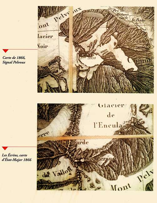
IGN minute extract of the Briançon map
Note the ‘S’ after the name of the Barre des Écrins possibly followed by ‘al’ (for Signal) or ‘et’ (for Sommet).
Note now the 1866 1/80 000 Ordnance map which bears no ‘Signal’ sign as can be seen in the enlargement above and the larger map section below.
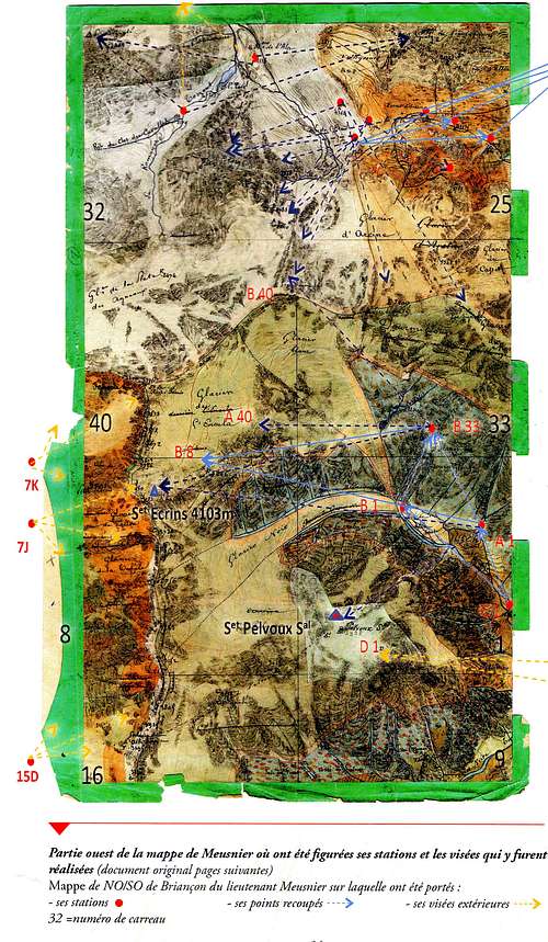
Meusnier mappe with his stations and points taken
On the 1/40 000 draft the Pelvoux has a known and well recognized ‘Signal’ on top of Pelvoux, while on the same draft the Barre des Écrins has also a mention but where it is difficult to distinguish if it is ‘Set’ for Sommet or ‘Sal’ for Signal.
However when the authors examined the table of the geographical points on the side of the same draft, the Pelvoux ‘Signal’ is mentioned while there is no such mention for the Écrins.
There is therefore an obvious discrepancy between the table and the map itself of that draft. The officers doing the mapping did draw ‘pre-drafts’ (‘mappes’) which were the nearest documents to their field operations. When they examined Meunier’s they found no mention of a ‘Signal’ for the Écrins.
The document digitized with that mention is most probably just a working document (one of the copies of the true draft).
A number of copies were done for the Army staff and the authors underline that 13 years passed during which many copies were made, a number for joining and linking the map individual sheets together and those copies circulated from multiple hands before the final engraving of the map. It is unfortunate that the IGN only has one unique copy of this sheet contrarily to the 274 other sheets of the full Ordnance map.
It is this copy which was digitized on the Géoportail Web site used by Olivier Joseph and his accomplices.
This mention of ‘Sal’ is most undoubtedly a transcription error. This is verified by looking at the pre-draft of Captain Bourgeois, a colleague of Meusnier, on which there is a mention besides the name ‘Les Écrins 4103m’. The mention is ‘Set’ for ‘Sommet’. Therefore it must be this mention which was transformed in ‘Sal’ by one of the many persons who were working on the document between the land surveys and the engraving operation.
The authors conclude:
“The lack of critical analysis of this document has been used as a starting point to an erroneous interpretation. For human sciences it is clear that one source must be cross-checked and that one only testimonial cannot be held as a proof:
‘TESTIS UNUS, TESTIS NULLUS’.
WHY WOULD THOSE ASCENTS HAVE NEVER BEEN MENTIONNED?
In their analysis, the authors find no reason either individual ones or from the Army staff which would explain that such ‘first ascents’ would not have been mentioned. There was no military strategic aspect attached to the mapping of this area which otherwise could have meant imposing secrecy.
Contrarily to the plot invoked that the French Alpine Club and Mountaineering historians would have deliberately written the history within their small circle and to their own benefit, the reverse can be noted particularly with General Hurault - head of the IGN - who made a significant contribution to the book "Les alpinistes célèbres" - 1956, in describing the well-established performances of Adrien Durand : Durand started the Briançon area mapping (1828-1830), found with a sighting from the Montagne de Lure that the highest summit of the range was the "Pointe des Arsines" which will become "The Barre des Ecrins" and measuring it at 4105 m. In 1828 he erected a ‘Signal’ on the Pelvoux rocky summit secondary top 3928 m in 1828 (now called Pointe Durand), a particularly daring feat repeated the following day to complete the pyramid. The snowy and main summit 3943 m (then named Pointe Puiseux) was climbed in 1848 by Jean Puiseux. But Hurault does not mention the so-called first ascents of 1853.
Durand did not think useful to reach the snowy summit, 500 m distant and 11 meters higher as his task was not to climb summits but to map the area and that was the case of all the Army cartographers who continued his work, namely in the 1851-1853 campaign. Those officers mostly from Polytechnique did work in very difficult and harassing weather conditions. Durand himself suffered such strains that he died a few years after at the early age of 48. This is also significant with Henry Beraldi (writer, historian attached to the ministry of Defence - 1849-1931) exalting the ascents and mapping feats of Captain Durand on Pelvoux (1828-1830) and his successor, Captain Davout (1851-1853), over many pages of his book Balaïtous and Pelvoux. Never does he mention them and their officers/cartographers such as Meusnier to have climbed other summits than the Pelvoux during those mapping campaigns. But a bit later in his book, he extols the Écrins’s ascent by Whymper, Moore, Walker, Almer and Croz.
Why a writer quite critical of alpinism would have ignored any major ascents of his Army colleagues after having had access to those essential mapping archives?
The many contacts and exchange of information between the French Army, the Alpine Clubs and alpinists such as F. F. Tuckett and A. Adams-Reilly who made a number of climbs with some of those French Army officers prove the contrary.
The authors mentioned a visit of Francis Fox Tuckett to the French War office Dépôt [the unit in charge of producing the “carte d’État-Major”] showing the close and open links between the French scientific communities, the French Army officers in charge of the mapping and the Alpine Club members. This visit is described in a long and detailed article Tuckett wrote in the Alpine Journal (1863 - Vol I. pp. 145-179) and read to the AC members in June 1863 ‘Explorations in The Alps of Dauphiné during the month of July 1862’. He was then curtly received by General Blondel, director of the War “Dépôt” and “given access to” the Briançon map and “the original memoranda of the officers of the État-Major”. Extract from his article:
“…I met with the most courteous reception from General Blondel, director of the ‘Dépôt’, who gave me the freest access to maps and MSS including theoriginal memoranda of the officers of the État-Major., allowed me the utmost liberty in making notes, and, besides permitting me to have printed copies of several unfinished and of course unpublished sheets, furnished me with a manuscript one, beautifully executed by draughtsmen of the ‘Bureau’ of the most important portion of the four MS sheets of the ‘Feuille’ Briançon on the same scale as the original… This last is partially engraved, being now, as it is termed, ‘au trait’; i.e. the rivers, roads, names of places, heights and outlines (dotted) of mountains and glaciers are given, but no shading, nothing that represent relief. M. le Commandant Brossard, head of the engraving department, informed me that this sheet would certainly be ready for publication in six years, and very probably in five. The superintendent of the topographical department, M. le Colonel Bertrand, handed me over, after reading the general’s order, to M. le commandant Loupôt, a most pleasant, polite, and intelligent gentleman, whose kindness I shall not soon forget. He seemed as though he could not do enough to meet my wishes, and most energetically seconded all my applications to ‘his chef’. The four original MS sheets, on a scale of 1/40 000, which form the basis of the future ‘Feuille’ Briançon, are the result ofthe following labours:
Première
triangulation - 1828 - 9-30..M. le commandant Durand.
Seconde
triangulation - 1851 - 2 ….. M. Davoût (Capitaine?)
La
Topographie (détails) …………. M.M. les Capitaines Viroux, Valette, Taffin,
Beaudouin, Bourgeois, Smet, Vuillemot, Courier, Cousinard,Versigny, and le lieutenant Meusnier.
Of these gentlemen, M.M.
Bourgeois, Courier, Cousinard and Meusnier executed that portion which is
included in the copy supplied to me, and of which a photographic reduction has
been deposited at the rooms of the Alpine Club. From the large number of lofty
summits ascended by them, I was led to anticipate a degree of accuracy which
subsequent minute examination on the spot completely confirmed. With Commandant
Durand the survey of this group of mountains was a labour of love to which he
devoted all his energies…. His successors appear, however, to have worked with
equal intelligence and accuracy, and the result is a map which for faithful
rendering of details will almost compare with those of the Swiss survey… The Feuille
Briançon, now partially engraved is on a scale of 1/80 000, like all the other
sheets of the map of the ‘État-Major Français’... And I have reason to believe
that the future Briançon sheet, N°189, will be a credit to the French
engineers….”
A recognition in due form of the work done by those French officers but also clear evidence that he was told what summits they had climbed and not climbed, and certainly none of the summits claimed by Joseph Olivier and his abettors.
Tuckett did then supply the documentation to Whymper which will enable him to ascend the Écrins.
This collaboration between alpinists and the French Army cartographers continued strongly until all the Alps were in the end fully and properly mapped thanks particularly latter to the French Alpine Club alpinists and cartographers of whom the famous Paul Helbronner and Henry Vallot. The French Army was immensely thankful for their work which allowed to complete a modern mapping of the Alps.
Sketch of the Ecrins by F.F. Tuckett - July 1862 Alpine Journal (1863 - Vol I. pp. 176)
The French Army officers and members of the French Alpine Club in the 18th and 19th century similarly to the AC members had the same Middle Upper class social origin and shared their work quite openly and efficiently. Indeed a number of those French Army officers were members of the French Alpine Club from its start (1874).
The theory of a ‘plot’ of the Alpine Clubs is as ludicrous as this ‘revolutionary discovery’.
The supremacy of the British in the advent of sport mountaineering can be irritating to a number of French, but it is a reality well established. It is true though that the mapping work undertaken by those French Army officers in difficult and often precarious conditions was a feat significant enough to be remembered as in doing so they were the first ascensionists climbing several significant summits in the Alps and the Pyréénées. This would deserve more recognition but certainly not at the expense of the historical truth, they have never climbed the Barre des Ecrins and the main summits of the range.
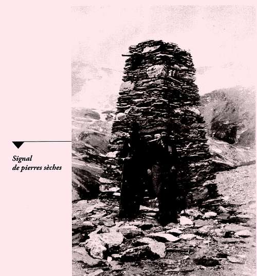
Typical Signal erected at that time
Sources:
· Des Ascensions Oubliées - Les opérations de la carte d’État-major de Briançon au XIXème siècle. Michèle Janin-Thivos et Michel Tailland (Editions du Fournel - Septembre 2016).
·Alpine Journal December 1863 (Vol I. pp. 145-179) F.F. Tuckett, ‘Explorations in The Alps of Dauphiné during the month of July 1862’


Comments
Post a Comment