Introduction
Back in 2003, my son Chris, who was 17 at the time, and I decided to do a week long backpacking trip in Rocky Mountain National Park. Aside from being our longest trip together it was also our first A to B trip. We’d cross the park from east to west, a distance of a little over 20 miles. Not an expedition by any stretch, but a challenging undertaking for us at the time.
![Mummy Traverse Map]() Our route in red, from east to west across the range. Side trips in blue. Starting and ending points and camps marked by yellow diamonds.
Our route in red, from east to west across the range. Side trips in blue. Starting and ending points and camps marked by yellow diamonds. Best viewed in large format
Basically, we’d head west up the North Fork of the Big Thompson River, continue west off-trail, crossing the spine of the Mummy Range at Icefield Pass. From there we’d resume traveling cross-country, getting back on trail at Mummy Pass, follow that trail down to the Cache La Poudre River then along the river trail before turning up Corral Creek to the Corral Creek TH, which is where our trip would end. The crux of the route would be the crossing of Icefield Pass.
Aside from completing the journey, we hoped to climb the highest summit in the Mummy Range, 13,561 foot-Hagues Peak and also to catch a rare Greenback Cutthroat trout from one of the Range's high lakes.
Day 1 - August 9th ~ Let the Wild Rumpus Begin
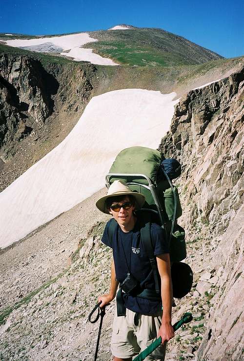
After picking up our permit at the backcountry office we were off to the Dunraven TH. Weighed our packs before hitting the trail-Chris’ was 38lbs, mine was 46. We’d left a lot of our usual stuff behind but it still felt like we had way too much!
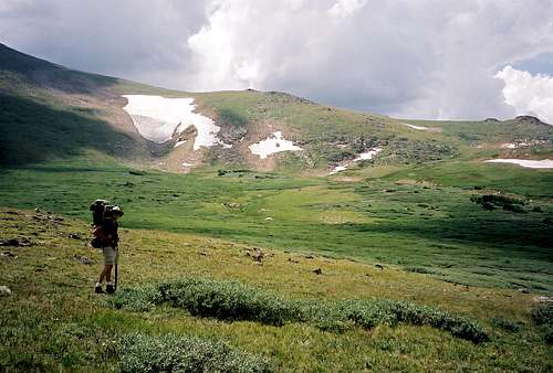
It was a pleasant enough track, winding along the North Fork through pines and aspens and lined in places with wild raspberries which we sampled along the way. The trail seemed kind of crowded with backpackers, which was surprising to me. I thought this place was off the beaten path, far from the crowds of Glacier Gorge and Bear Lake. One group that we encountered seemed a bit out of place, carrying their sleeping bags in their arms and toting small packs on their backs. They told us they were hiking all the way in to Lost Lake in one day. Better them than us, I thought. Over 9 miles on the first day was more than I was ready for! Additionally, I was suffering from Plantar Facitis and after not too many miles on the trail, I was ready to sit down for a while. So, at 5.6 miles, we turned off the trail to look for our campsite.
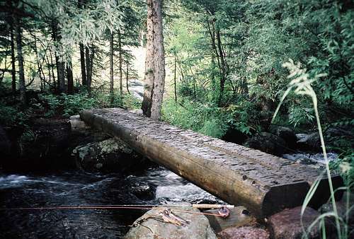
![Log Bridge at Half-Way]() Log Bridge to our campsite across over the tiny North Fork of the Big Thompson
Log Bridge to our campsite across over the tiny North Fork of the Big Thompson
A rain shower started as we crossed the log bridge over the river in search of a site. We took the unoccupied site and waited for the rain to stop. Fortunately the rain didn’t last too long and we got to work setting up camp. It did however make everything quite wet which would make starting a campfire later on a challenge.
![Half-Way camp]() Chris going about setting up camp at Half-Way after the rain
Chris going about setting up camp at Half-Way after the rain
While unpacking, I discovered that the brandy flask I’d brought was leaking. Thankfully, it was in a plastic bag which prevented the leakage from fouling the rest of my gear. Not wanting to press my luck, I made a decision that we needed consume all the brandy that evening.
Chris fished the North Fork while I gathered the driest wood I could find. When he returned with three trout I did my best to get a fire going so that we could cook the fish and generate a little warmth to ward off the damp chill that had set in. Took a while to get the fire started and even longer before it was hot enough to cook the trout. After a fine meal we began the task of consuming the brandy. Between drinking it and blowing it on the fire, we got the job done. Sadly, when it was done, we realized that we hadn’t hung our food bag. Ruh Roh, another challenge! Finding a suitable tree was hard enough, the rest of the task proved virtually impossible, but at the time it seemed like we’d gotten it done. In the morning we could only laugh when we saw our handiwork. The bag was hanging from a tree all right, six feet above the ground! Thankfully, we dodged a bullet this time.
Day 2 ~ The Icefield Cometh.....into View
Moving a little slow this morning, partly due to the previous night’s escapades but mostly because we didn’t have too far to go, only about 4 miles to our next camp. It would be a steeper stretch of trail so we were planning on taking it slow and having a few breaks along the way. At the last rest stop we cooled our heels in the icy waters of the North Fork while watching a trout feeding in a pool just below us. A good sign!
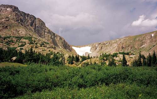
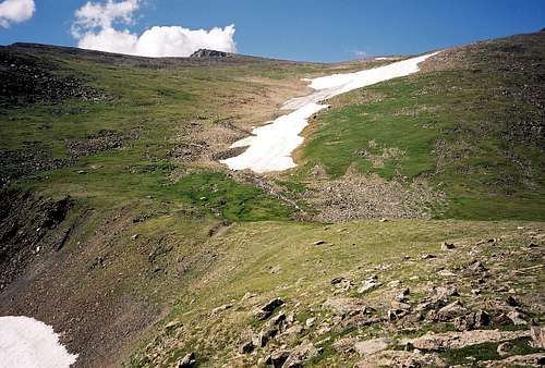
In a meadow another 1/2 mile up the trail, we got our first glimpse of Icefield Pass. After months of seeing it only in a photo and in our mind’s eye it was an almost overpowering feeling to see it for real.
![Icefield Pass]() Our first glimpse of the pass.
Our first glimpse of the pass.
The trail leveled out somewhat as we approached Lost Lake. Just below the lake, we saw a sign indicating that there were two campsites to the right, up a small hill. We went to check them out, leaving our packs by the trail. The first one was occupied, the second one was not a very good spot, so we moved on. The next two spots were unoccupied and looked good, so we chose the one closest to the lake. We felt good knowing that we wouldn’t have to move camp for three nights. Got everything set up, kicked back to relax and give my heel some weight-free time.
Continued to be amazed at the number of people about. There seemed to be at least two groups camped across the lake and another in the trees at the west end of the lake. I didn’t understand how those people could be camped there. There’s only four designated sites in the area and they were right by us. Illegal campers is all I could figure and as far as I could tell, they never got busted.
Went down to the lake to try a little fishing after dinner. I don’t think either one of us ever made a cast. The surface of the lake was dead calm and in all the time we watched, we never saw a rise or a dimple on the surface. Kind of unusual for a lake like this right before dusk. We traded our rods for my cell phone and found some service on top of a large boulder where we called home and talked to the girls.
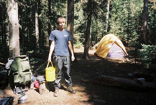
![Chris at our Lost Lake camp]() Our Lost Lake camp, complete with a vintage cooking set-up.
Our Lost Lake camp, complete with a vintage cooking set-up.
Since fires weren’t allowed at this site, Chris lit a candle and we sat around it, talking for a while. Then we carefully hung the food bag and turned in. Meanwhile, the gang at the west end of the lake was starting to stir. We drifted off to sleep just as their hootin’ and hollarin’ really got goin’.
Day 3 ~ Quest for Greenbacks and a Route
Our plan for this day was to hike to the lakes above us and to the snowfield at the pass with two goals in mind. First, to catch some greenbacks, and secondly to reconnoiter the pass in preparation for our crossing in two days.
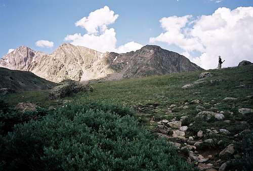
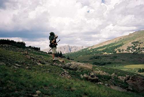
![Three un-named Peaks]() Three unnamed peaks south of the pass. I heard them referred to, from left to right, as Gibraltar and unnamed middle and north.
Three unnamed peaks south of the pass. I heard them referred to, from left to right, as Gibraltar and unnamed middle and north.
We started following the faint trail behind our campsite the led west. Just below treeline the path disappeared and we continued traveling across the open tundra toward Lake Louise. Several folks were at the lake when we arrived, fishing with lures and apparently having no success. A small thunderstorm rolled through after which the fishing picked up. We caught and released a few greenbacks before moving on to our second goal, the pass.
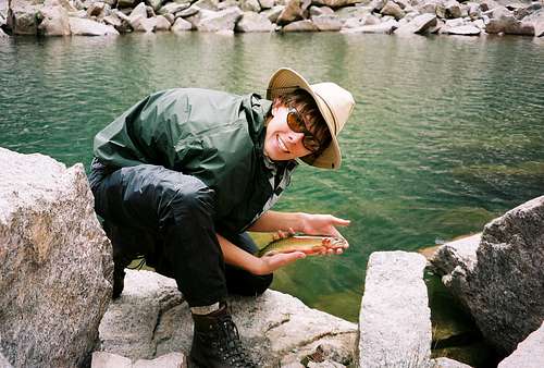
![An excitable boy with his 1st Greenback Cutthroat]() Chris with his first greenback!
Chris with his first greenback!
Left our packs and fishing gear at the lake and climbed toward the pass to find a route up the snowfield or around it.
![Lake Louise]() Looking east over Lake Louise
Looking east over Lake Louise
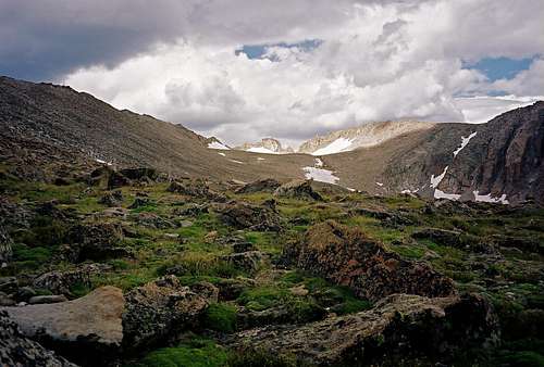
We’d left our snow climbing gear at home based on info we got from a Colorado Mountain Club trip leader who’d led a group over the pass in July. He thought the snowfield would be rock hard ice for our crossing in August and suggested that we use the same route they’d used, one of the chutes on the north side of the snowfield. It didn’t look too bad but it was very steep.
![Terminal Moraine]() The mini terminal moraine under Icefield Pass
The mini terminal moraine under Icefield Pass![The glacier s last advance]() Terminal moraine left over from the last glacial push.
Terminal moraine left over from the last glacial push.
Glancing back at the snowfield, I wished that we’d brought the snow gear. It looked pretty straight forward compared to finding a route up that steep chute. At any rate, we did what we set out to do this day and headed back to camp just as some more weather was moving in.
![Icefield Pass]() Icefield Pass
Icefield Pass
Had a good dinner and called home afterwards. Our goal for the next day was to climb 13,560’ Hagues Peak and we wanted to get an early start. With my radio alarm set at 5:15, we settled in for the evening, serenaded once again by our rowdy neighbors at the end of the lake.
Day 4 ~ Weather Threats rule the day
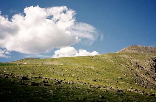
Ooooooops! Somehow I mistakenly set the alarm for 6:15 instead of 5:15. Moving as quickly as we could, we gathered our gear and made our way up the hill behind camp. As we got above the krummholtz, we drifted south past Lake Husted then dropped down to the bottom of the drainage where we crossed diminutive flow of the North Fork. Once on the other side, we began working our way up a steep, rocky draw that led to the ridge top. We followed that ridge all the way to the upper slopes.
The weather to this point had been perfect, not a cloud in the sky. Lake Dunraven came into view far below us and to our right as we gained altitude. The first clouds appeared as we reached about 11,500 feet. We continued up in the thinning air, breathing a little heavier and keeping a watchful eye on the clouds building to the west.
![Hagues Peak Ridge]() East end of Hagues summit ridge, weather still good but some clouds starting to appear.
East end of Hagues summit ridge, weather still good but some clouds starting to appear.
Nearing 12,000 feet, we were surprised to see a person carrying a large backpack. Turned out that she was our neighbor and she was doing some kind of research. She went down the slope, aiming for the Dunraven lakes below and we pushed on. The climb steepened and we found ourselves moving through an area of scattered, large boulders
![Rowe Peak]() Rowe Peak with not so happy clouds building behind
Rowe Peak with not so happy clouds building behind
After passing a small knob at about 13,000 feet we took a break on a flat spot. We still had a little climbing yet to do but most of what was left looked to be a walk on the summit ridge. The ridge was maybe 1/2 to 3/4 of a mile long, with the summit at the west end. With that in mind, we took a last look at the clouds before starting for the ridge. They were definitely looking darker and more menacing than they had just a little earlier. We decided that if lightning started bouncing around, which at that point looked imminent, that ridge would not be a good place to be, so we bailed and started back down. As the wind kicked up, the temperature plummeted. We zipped up all the zips and moved briskly down the slope, feeling that we made the right decision.
As we neared the North Fork crossing at the bottom, skies suddenly cleared and the sun shone brightly. Oh well, can't win em' all.
With all that sunshine, it was getting downright hot as we approached our camp and the lake. We started kicking around the idea of taking a swim to cool off. By the time we were ready and at the waters edge, the same weather Gods that brought the dark clouds to the summit brought them once again, obscuring the sun, ending our chances of taking a dip. Our sour luck continued. The evening's dinner, Natural High Enchiladas, was the worst meal of the trip. Some of that brandy would have been real nice about now!
Sitting around our shrinking candle, we pondered the next day’s hike. It would be critical to start as early as possible. Being unsure of how long it would take us to ascend the pass and then make it through the off-trail bushwack beyond, I carefully set the alarm for 4:45 AM.
Day 5 ~Up and Over
The alarm went off as planned. We shuffled around in the predawn darkness, trying to pack it up and be ready to roll by 6. It was close. We were on the trail at 6:30.
Not long after we started I realized that something was wrong with the load leveler feature on my pack. Normally you can pull the upper part of the pack closer to your shoulders by pulling the load leveler straps tight. For some unknown reason it wasn’t working and I was having to lean farther forward to compensate for it. Certainly not the best scenario I could have chosen for the steep climb to the top of the pass. I guessed that when I reassembled the removable components of my pack that we’d used for our day hikes, I did a less than stellar job of it. We made several stops, during which I tried to correct the problem to no avail. Had no choice but to push on.
All things considered, it wasn’t going too badly. We reached the west end of Lake Louise at 8:00 and the base of the pass shortly thereafter, at about 8:30. Took a break before starting the steep climb, to catch our breath, hydrate and do a couple Clif shots.
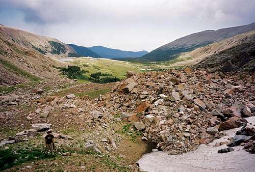
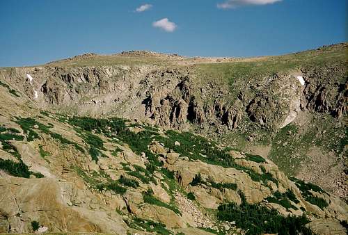
![Skull Point]() Skull Point and the area where we picked our way to the top
Skull Point and the area where we picked our way to the top
From there we switchbacked up the slope to the north of the snowfield, aiming for the couloir that we hoped would provide us with a path to the top. Below the rock piles that acted as a sort of gateway to the bottom of our intended route, we split up, hedging our bets in case one of us ran into a dead-end, staying in touch with our two-way radios. We encountered no problems and met up at the bottom of the couloir.
It was much steeper than it had appeared from below. With each step the pitch seemed sharper and the footing less stable. In places, handholds became necessary. Before we started up, I had given one of my trekking poles to Chris for stability. It seemed to help but I was still concerned as he was carrying his fly rod in his free hand. I took his rod, clutching it with my trekking pole so that he could grab onto the rocks as needed. At this point, it was difficult to look back down.
![Icefield Pass RMNP Colorado]() Chris nearing the top with the pass and Icefield behind
Chris nearing the top with the pass and Icefield behind
I was glad his mother couldn’t see what I had her son doing!! Even gladder when a grassy ridgeline, that looked to be the top, appeared some thirty vertical feet ahead. Five minutes later, we stood on the top. Our route put us a couple hundred yards east and north of the actual pass, so we made our way along the ridge to the pass. We stood there for a while, taking it all in and thinking about what we had done. And we were mighty glad that we were done doing it!
![Looking west from Icefield Pass RMNP Colorado]() Looking west from the pass to the Never Summer and Medincine Bow Ranges
Looking west from the pass to the Never Summer and Medincine Bow Ranges
The icefield for which the pass is named was impressive. It lay just south of the pass in a shallow gully. It was long and narrow, with a portion of it appearing to be solid ice. An icy torrent gushed from it’s snout, rushing downward, passing within a few yards of the pass. At some point in the past, an ambitious individual had apparently tried to divert the flow over the pass to the Big Thompson drainage.
![The Icefield]() The Icefield
The Icefield
Somebody must have put a stop to that and this continues to be the source of the SF of the Cache La Poudre.
![Icefield outflow]() Outflow from the Icefield, the source of the SF of the Cache La Poudre
Outflow from the Icefield, the source of the SF of the Cache La Poudre
We took a well deserved break next to the water to rest up, eat and soak our feet in ridiculously cold water. Also, we called Lynda at work to tell her that we’d made it up the pass and to confirm our rendezvous arrangements for the following Saturday at 2 pm at the Corral Creek TH, three days from now. We said our goodbyes, knowing that this would be our last communication until then.
A mere four miles was all that remained between us and our next camp, at Mummy Pass Creek. The next two miles of which would be my favorite kind of travel, off-trail, in open country. Fortunately, the weather thus far had been good, but as usual, clouds were starting to build to the west.
After crossing the icefield outflow, we found ourselves facing a vast “sea” of willows.
![The Sea of Willows]() The Sea of Willows
The Sea of Willows![Looking east toward Icefield Pass]() Looking back toward the pass, Skull Point on the left
Looking back toward the pass, Skull Point on the left
Didn’t look too difficult, just a matter of finding the path of least resistance, which took us a little while until we stumbled onto an “Elk Highway”. That highway eventually led us to the other side of the willows, where we crossed a small creek that flowed out of a nearby snowfield. Following the ridgeline that we’d seen from the other side of the sea of willows, we worked our way in the general direction of Mummy Pass.
![My son-The Backpacker]() Approaching the Mummy Pass trail
Approaching the Mummy Pass trail
After going through another patch of willows, we worked our way across a rocky hillside and finally ended up on the Mummy Pass trail. By this time, the day was growing long and we were growing weary. We plodded along for another couple miles until we came upon the first designated campsite at about 2:30. It was occupied so we moved on, crossing a footbridge that spanned Mummy Pass Creek and following the signs to site #2. Though not quite as choice as the first site, it was farther off the trail and close to the creek.
Got our camp set up, had a hot lunch and set about fine tuning our camp. It felt good to be in camp and we looked forward to sitting around a fire again. Skies cleared before sunset so we opted to leave the fly off and had a beautiful, airy sleep.
Day 6 ~ A Day of Rest
This day we designated as a hiking boot free day. Temp was cooler this morning, around 38 degrees. Not too bad considering where we were. And it appeared to be another bluebird day, no clouds to be seen. We had a big breakfast and started catching up on chores like washing some clothes and ourselves. Once that was done we went looking for dinner in the creek. Managed to catch a few small brookies. Also found a beat up grate in the other, now unoccupied site, that would serve us well when it came time to cook them.
![Desolation Peaks]() The Desolation Peaks from Mummy Pass Creek
The Desolation Peaks from Mummy Pass Creek
After lunch, we explored the immediate area around camp and checked out some views of a little seen part of the Mummies-the Desolation Peaks. Later in the afternoon, we drifted back to camp to begin preparing our gourmet meal of sautéed Salvelinus fontinalis with rice. It was a nice break from the freeze-dried regime. Went up to the meadow above our camp just before sunset to take in the views. Aside from seeing the surrounding peaks as alpenglow approached, we also spotted 5 moose, all bulls, including one that sported a huge 6’ rack. As the darkness grew, we ambled back to camp for a little fire before turning in.
Day 7 ~ Mirror Lake
This was our last full day of the trip and we were ready to put back on the hiking boots. The weather was perfect once again. Our plan was to hike to Mirror Lake which was only about a mile and a half away. As we imagined, the hike was very easy.
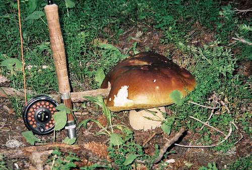
![Big Shroom-RMNP-Colorado]() Big Shroom along the Mirror Lake Trail
Big Shroom along the Mirror Lake Trail
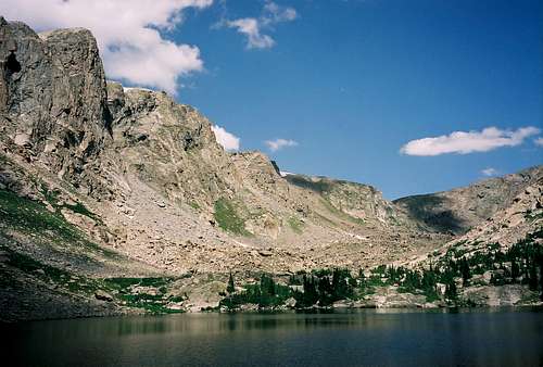
The trail meandered through old growth forest and pristine meadows before reaching the picture postcard, beautiful lake.
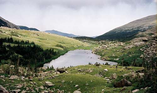
![Mirror Lake RMNP Colorado]() Mirror Lake
Mirror Lake
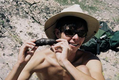
We saw no one, either on the trail or at the lake which just added to the magic of the day. For lunch, we shared a mud pie bar which looked a lot like a large turd but tasted incredible!
![Appearances can be deceiving]() Mirror Lake snack-The Mud Pie Bar
Mirror Lake snack-The Mud Pie Bar
The lake itself was spectacular! Nestled in a steep-sided cirque, open only to the south, it’s waters shone like an azure gem in the bright sunlight! We spent most of the day in the cirque, exploring and doing some fishing. We’d previously thought that we might include a climb of Comanche Peak while we were here, but we weren’t feeling quite that ambitious. When the shadows started to lengthen, we turned our boots southward and headed back to camp. Saw no one on the return trip and found that the other campsite was still unoccupied. We decided that this is a good place to escape the summer crowds of RMNP!
After dinner, with this being our last night in the backcountry, eating our last freeze-dried meal, we sat around the fire and talked about what cravings we’d satisfy first when we got out. Our rule has always been-No talk of the food and drink we were going to have until the last night of the trip.
We talked it up pretty good this night and we knew exactly what would be waiting for us at the trailhead. We’d put in our orders before we started and if things worked out as planned, my wife would be there, with the goods. Subway sandwiches for both of us, ice cold Snapples for Chris and frosty Coronas for me!
Day 8 ~ A Smooth Transition
Started the day by finishing up most of our remaining provisions. Had the last of the coffee, the last of the hot chocolate and the last of the oatmeal and burned up the last of the fuel in the process. Obviously, good planning!
It looked to be another beautiful day with morning temps a little cooler than the previous day. Cool enough that it caused us to put on some warmer, and to this point, unworn clothes. After taking care of morning business we realized that we were down to our last piece of paper, a quarter of a sheet of paper towel. That’s cutting things a little too close!
As we broke camp and started down the trail, the day was all ready warming up.
Things were shaping up nicely for the homestretch. Our packs were at their lightest, our legs were at their strongest and the 4.6 mile hike was pretty much all downhill, at least to the river. After a couple miles, we started seeing hikers coming up the trail, a sure sign we were leaving the really wild country behind. And of course, the farther we went, the more folks we encountered. All the while down the trail, we were thinking that we’d have to ford the river. As far as I knew, any bridges crossing this upper stretch of the Cache La Poudre had been washed away years ago. So, imagine our surprise when we reached the river and saw a big, beautiful, new bridge spanning it.
Everything was going so smoothly that we were way ahead of schedule. We needed to stop and take a break by the river to kill some time. We weren’t expecting to get to the trailhead until around 2 so rather than sit around there waiting for Lynda, we thought it better to sit by the river. Chris started fishing while I soaked my feet and tried to clean up a bit. Got as clean as I could under the circumstances and put on a fresh shirt, hoping I would be presentable at the trailhead. I’m sure that Lynda would be less than thrilled to have a smelly old man in her car for the two hour ride back to town.
Sufficiently rested, we got back on the trail for the final leg of our journey. The trail left the river and started climbing through the forest toward the end of the line at Corral Creek. Chris and I speculated as to whether Lynda was all ready there. It was 1:40, we were still 20 minutes early. Chris said he didn’t think so but I knew better. But I was still surprised when the radio chirped. It was Lynda, wondering if we had a copy. Without skipping a beat, I replied that we were indeed alive and only about five minutes away.
A joyous reunion followed as Lynda met us at the bridge just below the parking lot. Followed that up with a feast at the trailhead. Our shrunken stomachs filled quickly from the sandwiches and our thirst was quenched after a couple cold ones. I love being out there but it’s always great to come back!!
Comments
No comments posted yet.