

|
|
Mountain/Rock |
|---|---|
|
|
39.98300°N / 111.623°W |
|
|
10685 ft / 3257 m |
|
|
Overview
Santaquin Peak is two feet lower than the highest summit of Loafer Mountain, located just the southeast, but because it is north of Loafer, it is the prominent and visible peak viewed most of Utah County, and it is a much more angular, aesthetically pleasing peak than Loafer. If you must have the higher peak, Loafer can easily be added in the same trip. Also note that often the entire massif is known as Loafer Mountain.
The mountain is mostly made of limestone, but with beds of shale, quartzite, and dolomite.
Santaquin is climbed frequently, but not nearly as much as some other peaks surrounding the Utah Valley such as Mount Timpanogos or Mount Nebo.
The trails and routes up Santaquin are rather scenic and especially beautiful in the fall. The views of Payson Lakes, Mount Nebo, Mount Timpanogos, and the cities in the Utah Valley are really nice from the summit.
The mountain makes a fairly safe winter ascent as well.
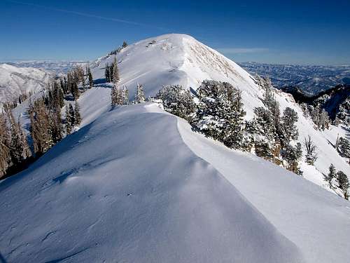 Santaquin Peak in December.
Getting There
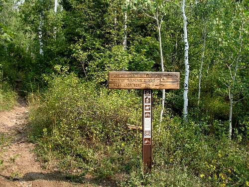
Payson Lakes Trailhead
Take I-15 exit 250. Take a left at 100 North, then turn right at 600 East (Peteetneet Boulevard) and follow it into Payson Canyon on the Nebo Scenic Loop Road. The primary trailhead is just before Payson Lakes (if coming from the north) and a small sign along the road says "Loafer Mountain Trail". This is 12.2 miles from the beginning of the Mount Nebo Scenic Loop Road and 0.1 miles before reaching the turnoff to Payson Lakes.
 A sign at the intersection of the Payson Lakes Trail and the Bennie Creek Cutoff. The sign is about 1.2 miles from the Payson Lakes Trailhead.
Bennie Creek Cutoff Trailhead
This is another possible trailhead. The Cutoff Trail also starts from the Mount Nebo Scenic Loop Road, but is a few miles before the Payson Lakes Trailhead. The trailhead is just over a mile past the Maple Bench campground.
Bennie Creek Trailhead
This trailhead accesses the south side of the mountain from the little community of Birdseye. To reach this trailhead, drive up Spanish Fork Canyon and turn south on Highway 89 towards Fairview and Manti. Drive past the ghost town of Thistle and just south of mile marker 273 (this may have changed?), turn right at the LDS Church and follow the gravel and dirt road up Bennie Creek and to the trailhead. The last section of the road can be rough for passenger cars.
Note: As of July 2021 the trails from Bennie Creek have been reported as overgrown or closed due to forest fires.
Routes Overview
Payson Lakes/Loafer Mountain Trail
This is the most popular route up the mountain. It is 11.4 miles round trip and with about 3200 feet elevation gain. The trail is well marked from the Payson Lakes Trailhead. See the route page for details.
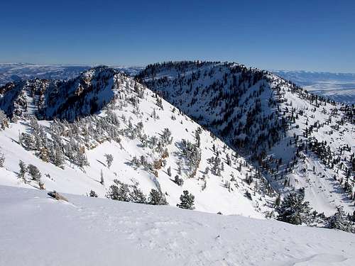
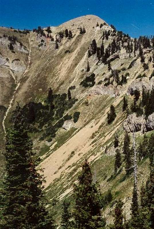 Santaquin Peak from the Loafer Mountain Trail.
Mud Hollow Route
This routes starts from the same trailhead as the Loafer Mountain Trail above. It can be used to make a nice loop hike with the standard route. Since the trail drops down Bennie Creek before climbing up Mud Hollow, it has more elevation gain than the standard route.
It was still a good trail when I used it in 1996, but I don't know of its current condition. After following the Loafer Mountain Trail for 1.2 miles, turn right and drop into the Bennie Creek Drainage. After reaching Mud Hollow, you will turn left and follow the trail up Mud Hollow until it intersects the ridge just south of the West Ridge of Loafer Mountain, where the standard trail is located. After reaching the standard Loafer Mountain Trail, follow it to the summit.
 The ridge above Mud Hollow.
Bennie Creek Cutoff Trail
Most of this trail follows the same route as the standard Loafer Mountain Trail, but the Cutoff Trail starts at a lower elevation from near the Maple Bench Campground. There is an extra ~800 feet elevation gain and about two miles extra each way when following this route. It makes a good winter route since the road is plowed to near the trailhead.
This route joins the standard Loafer Mountain Trail after about three miles.
Bennie Creek
The Bennie Creek side also has some good routes up Santaquin Peak and they are less used than the trails from Payson Lakes. You can either take the Bennie Creek Trail up Bennie Creek and to Mud Hollow (see above), or take the trail up Deer Hollow to the vicinity of Santaquin Peak. The Mahogany Ridge or the Southeast Ridge both make good routes. The elevation gain on any route is about 4300 feet.
Note: As of July 2021 the trails have been reported as overgrown or closed due to forest fires. This route is not currently recommended.
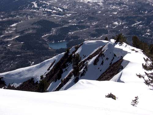
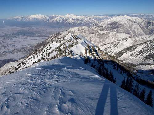 Looking north from Santaquin Peak.
Red Tape
There is no red tape here, so please take care of the area.
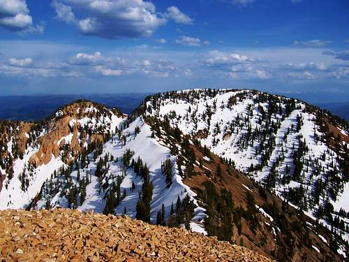
 Looking towards Loafer Mountain from Santaquin Peak. Please take care of the area.
When To Climb
Since most routes follow sunny ridge tops or south facing slopes, Santaquin Peak can be climbed without much snow from early to mid June until sometime in October.
Fall is a beautiful time to climb the peak.
In winter, Santaquin Peak is safer than most other Wasatch peaks at a similar elevation since most routes stick to ridge tops.
In winter (or spring), the Mount Nebo Scenic Loop Road is closed near the Maple Bench Campground and you will have to ski or snowshoe from there. The Bennie Creek Cutoff Trail is probably the best bet in winter.
On the Birdseye side, you won't be able to drive that far up Bennie Creek in winter, but you can always snowshoe or ski the road. This may be the shortest route up Santaquin Peak in the winter.
 Looking from Santaquin Peak to Loafer Mountain in late May.
Camping
There are many official campsites along the Nebo Scenic Loop in Uinta National Forest. You will need to make reservations to stay at these, at least on summer weekends.
The campgrounds in the vicinity of the trailheads are Maple Bench Campground, Maple Lake Campground, and the Payson Lakes Campgrounds.
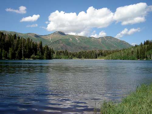 Payson Lakes.
On the Bennie Creek side, there are good campsites near the trailhead. This isn't an official campground, so please leave a clean campsite.
Of note, my wife and I camped on the summit on July 3-4 1996. We could see some fireworks far below, but it wasn't the best campsite. The wind was so strong during a microbrust that the stove blew away!
Mountain Conditions
CLICK HERE FOR WEATHER FORECAST
Below is the Climate Summary for Mount Baldy, located several miles north. The two mountains are listed are of similar elevation, so climate conditions should be fairly similar on either peak, but a couple of degrees warmer on Santaquin Peak.
| Month | High | Low | Precip (in) | Snowfall (in) |
| JAN | 21 | 8 | 7.99 | 110.9 |
| FEB | 23 | 9 | 7.52 | 103.7 |
| MAR | 28 | 12 | 8.13 | 117.6 |
| APR | 34 | 17 | 6.92 | 84.4 |
| MAY | 42 | 26 | 4.62 | 38.9 |
| JUN | 52 | 36 | 2.05 | 8.1 |
| JUL | 59 | 44 | 2.15 | 0.2 |
| AUG | 59 | 43 | 2.58 | 0.3 |
| SEP | 49 | 34 | 3.34 | 12.0 |
| OCT | 38 | 25 | 4.62 | 37.8 |
| NOV | 27 | 14 | 7.10 | 98.1 |
| DEC | 22 | 9 | 7.99 | 120.0 |
luke.mease@gmail.com - Jul 3, 2021 8:53 pm - Hasn't voted
Bennie Creek Trailhead/BIrdseye CLOSEDThe trail up from the Bennie Creek Trailhead (accessed from Birdseye) is closed, presumably due to fire within the past few seasons. According to a couple of hikers who recently braved the ascent from that (former) trailhead, route finding was relatively straightforward (follow the draw that starts at the "Trail Closed" sign up until you hit the big meadow in the cirque below Loafer mountain peak, in a pretty straight N/NW direction). It was, per these two, definitely not enjoyable. The former trail is reportedly already pretty overgrown and not feasibly followed, so it's either scrambling up crumbly rock in the creekbed or bushwhacking the steep terrain on either side. Per this pair- definitely not recommended. Also, per other information on the web, it appears that the Bennie Creek Trail proper (connecting the Birdseye/Bennie Creek (former) trailhead and the Loafer Mountain trail is also closed. Looks like for now the road up out of Birdseye will only get you a few miles of gravel road and maybe a skeptical wave from the cowboys working up there.
Scott - Jul 4, 2021 6:50 pm - Hasn't voted
Re: Bennie Creek Trailhead/BIrdseye CLOSEDOK thanks; I will update the page.