
|
|
Area/Range |
|---|---|
|
|
41.20268°S / 71.50211°W |
|
|
Hiking, Mountaineering, Trad Climbing, Sport Climbing, Scrambling, Skiing |
|
|
Spring, Summer, Fall, Winter |
|
|
7904 ft / 2409 m |
|
|
Overview
Imagine a wonderland of endless spires of quality granite bathed in alpine sun amid a backdrop of snow capped volcanoes, enormous alpine lakes, soaring condors, and friendly natives that know how to make pizza and chocolate. Indeed such a land does exist nestled on the east side of the Andes a short steep hike up from the chocolate filled streets of Bariloche in the lake district of Argentina. [Chelsea]
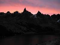
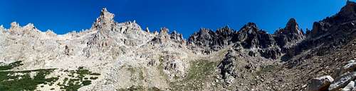
Cerro Catedral is regarded by many as the best rock climbing area in South America. Honey-coloured granite pinnacles surround a snow-filled basin. The rock is weathered, solid and breathtakingly beautiful. Sitting on a belay ledge high above the valley it is easy to see shapes and faces in the surrounding spires, as though they had been carved by some ancient civilisation rather than hewn by the weather. But then weather is something Patagonia has plenty of. The climbing area is well known as "Frey", a name that comes from the "Refugio Frey" (a 2 story hut that can have around 30 people). [ricardo]
(For reference, Cerro Catedral is a mountain of sorts outside Bariloche. It's been heavily shaped by long since gone glaciers leaving dozens of subsidiary peaks. The name of the mountain comes from the amphitheatre of spires that make up its high points, running from Catedral Norte to Catedral Sur through the highpoint of Torre Principal. This is the Frey climbing area though only the beginning of the possibilities.)
Note - This page was recently adopted from Chelsea and updated while absorbing the redundant Cerro Catedral page created by ricardo. Original author contributions have been attributed as appropriate. Depending on subsequent SP contributions the organisation of this page may change in future.

To the Trailhead
Getting to Bariloche:
Arrival into Bariloche, Argentina can be easily accomplished via plane or bus. Bariloche is the place to stock up on food and eat lots of ice-cream and chocolate. It is a very ritzy ski resort town but one can find many cheap hostels that will store travel equipment that does not need to be packed up to the Frey. [Chelsea]

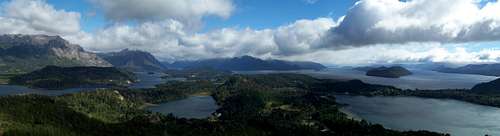
Bariloche from across the lake
There are long distance buses to/from Chile (e.g. Puerto Montt, Villarrica, Santiago etc., all via Osorno) and Argentina (El Calafate, Mendoza, B.A. etc). It's generally a good idea to buy your ticket in advance by a day or two as they can get packed out. There are also buses to/from intermediate destinations such as El Bolson, Esquel, San Martin de los Andes and Villa la Angostura.
The bus station is around 3 km east from the town centre with the lake on the north side. Its possible to walk alongside a highway to get into town but there are local buses and taxis which can take you. The local bus service runs from a stop between the terminal and the train station building. The taxi stand is just outside also. A key thing to note here if you're arriving from Chile is that the bus terminal has no ATMs or money exchange facility. So make sure to have some local currency before arriving if you plan to take a bus/taxi.
A special route that combines bus and boat travel via several of the lakes on the way from/to Puerto Montt in Chile is also an option. Apparently it's very scenic but you'd be advised to plan for a time when the weather's good on both sides of the border. There's also an airport though keep an eye out for ash advisories due to the persistent eruption by Puyehue-Cordón Caulle in Chile.
Getting to Cerro Catedral:
Cerro Catedral is easier described as a massif than a mountain and being quite large in extent has multiple access points. For going to the Frey area the point to head to is Villa Catedral, a ski village on the NE side of Cerro Catedral, and 20 km by road S/SW of Bariloche. Some alternatives are discussed where applicable.
The most convenient way to Villa Catedral is perhaps is to take a local bus from the 3 de Mayo company that runs from the main bus terminal, through Bariloche by one of 2 routes (Pioneros and Bustillo, with stops) and up to Villa Catedral at 90 minute intervals, from around 7am to 7pm. It will say "Cerro Catedral" on the front of the bus somewhere. The trip itself takes around 30 minutes. Price 8-10 pesos. Pick up an up to date schedule at Perito Moreno 480 and/or check the one on their website here.
Pioneros bus stops include Perito Moreno and Onelli (junction), Perito Moreno between Palacios and Beschtedt, San Martin and Pagano (junction, opposite P. Nacionales), with Bustillo bus stops including Neymeyer and Morales (junction).
|
View Larger Map (if no image above, right-click area and refresh) |
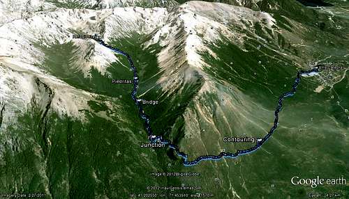
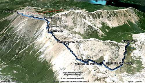
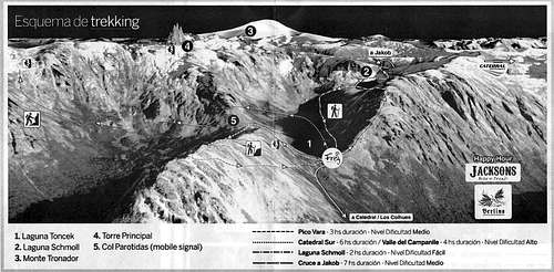
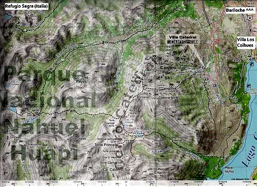 Cerro Catedral route map (click to expand) Cerro Catedral route map (click to expand) |
Into the Frey
There are a two main ways to get to the Frey area from this side of things, one a gentle hike past lakes and through forest, the other an airy ridge traverse with some scrambles thrown in for fun. Each has some variations as described below. Depending on the weather, how much you're carrying and what mood you're in your selection will likely vary. Access from the other side of the mountain is also discussed. Both these sections are choices for the first day of the Nahuel Huapi Traverse (see more in 'Nearby Climbs' below). They can also be combined as a loop to make for a nice day trip, beginning and ending at Villa Catedral.
Lake + Forest route/s:

Average scenery
This is an easy trail based route that first runs horizontally south around the mountain with a lake view before turning and heading directly up a deep river valley towards Frey while immersed in some lovely trees. It's only really when you get to the Frey however that the views particularly impress. A good route if the weather is erratic, windy, or if you've got an unwieldy pack. There are two different starting options to this trail and they come together for the river valley section mentioned above.
Option 1) From Villa Catedral: 10 km, 4-6 hours, 700 m gain.
Probably the most popular route up to the Frey, not just for climbers but for those interested in general enjoyment of the surroundings. As such you may run into a lot of other people. Begin in the SW of the main carpark where you get off the bus and hike along a short trail till you hit a road. On the other side of the road you should see a sign directing you towards Refugio Lynch. Contour south round the mountain for 3-4 kms along a well worn trail through scrub (quila and ñirre), taking in the views of Lago Gutierrez to your left. Towards the end it bends to the right and heads up a little more steeply before reaching a junction with the left path going down to the lake and the right path heading up the Arroyo Van Titter river valley towards Frey.
Option 2) From Lago Gutierrez: 11-13 km, 5-7 hours, 950 m gain.
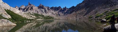
Cerro Catedral spires from Refugio Frey
A second option begins at the lake side, either in Villa Los Coihues or at the campsite on the western shore. Buses run every 20 minutes to Bariloche and there is a boat service that runs between Villa Los Coihues and the campsite though a road can also be used. The trail runs from the camp southwards, again going around the mountain but this time climbing gently above the lake. Initially you are in coihues forest but soon are without shade amongst bushes. Once at Arroyo Van Titter the path has a junction where you should take a right to reach the main path via a steeper section. The total gain from the lake to where you meet the path from Option 1 is around 350 m.
Options 1 + 2) Arroyo Van Titter to Frey:
From the point where the two above routes meet at the bottom of Arroyo Van Titter, climb upwards along the path through shady lenga trees with the pleasant sound of rushing water in you ears (if it's not too busy). The trail is pretty direct though gentle along the right hand side of the river and around half way you will cross a bridge to the left hand side. Soon you will come to Refugio Piedritas where there's some open space to take a break. From here it's around 2 km to Frey with 400 m of gain as you pass up the side of Pico Bara. Let the view at the end spur you on.
GPS info and 3D map for Option 1 route above:
|
 3D route map for Option 1 (click to expand) 3D route map for Option 1 (click to expand) |
Cordon Catedral route/s:
A more adventurous route to the Frey is along the side of the ridge that runs between Piedra del Condor and Torre Piramidal, before dropping down into the Frey amphitheatre. This is not difficult but does at times involve use of hands and some scramble-esque down-climbing for short sections towards the end so you need to be prepared for that. Good for huge views and some excitement, or if you want to bypass Frey and go on to the next refugio. Make sure to check weather conditions before hand, particularly snow and ice cover. There are two ways to reach the ridge as described below:
Option 1) Using ski-lifts: 6 km, 4 hours, -200 m gain.
There's a series of cable cars and ski-lifts which can take you from Villa Catedral at around 1050 m to Refugio Lynch on the ridge above at 2042 m. There is a cost but it can be taken for half price (40 pesos?) if you say you are only going one way when buying your ticket from the kiosk. You can take a pack, but be prepared to control it on a small swaying seat high above the ground. The lifts don't always run, depending on the day of the week and weather conditions so make sure to look up the schedule first. To get to the cable car base head north from where you get off the bus along the road and it'll be about 200 m up on your right. Another option is to take a ski-lift up to Piedra del Condor at 1759 m and then head to Refugio Lynch, or take one up towards Punta Nevada (2055 m). These latter two may not run all year however, perhaps preferring the ski season.
Option 2) Hiking all the way: 10 km, 6-7 hours, +1000 m, -200 m gain.
If the lift options aren't for you you can hike up to the ridge via some easy dirt paths that cover the side of the mountain. Note that it's about a 1000 m climb so will take you that extra time. These paths top out at various points including Refugio Lynch and Punta Nevada. Another route onto the ridge goes from the west of Villa Catedral along paths then a ridge to Punta Princessa.
Options 1 + 2) Ridge traverse to Frey:
Once atop the main ridge, which is pretty flat topped, using any of the above choices make your way to the beginning of the trail that passes around the west side of Punta Princessa and the Cordon de Catedral. Keep an eye out for posts marked with yellow paint as a guide though these may be as much to stop people heading off the edge by accident when there's a lot of snow about. The traverse begins just past a large sign warning you of what you're about to attempt and that the route isn't supervised by rangers, plus some emergency phone numbers.
 Cerro Catedral crest with marker posts Cerro Catedral crest with marker posts |
 Route ahead Route ahead |
The route from here to Cancha de Futbol at the other end of the traverse is quite airy as you traverse a steep slope via a thin path with peaks on your left and a deep valley on your right. The trail has some ups and downs with the odd use of hands but is fairly straightforward. The route is marked by red and yellow circles of paint at intervals though it may not always be easy to spot them. Given that the path is the same colour as the surroundings it is advised not to proceed without understanding where the route it's possible to leave it without realising. About half way along (between Punta Princessa and Roca Inclinada) you come back up to the ridge top and can see back towards the east. It's an open sandy area which may be good for taking a break. It may also be possible to descend back towards the east from this point though I don't know if there's a path.
 Route finding Route finding |
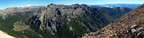 Cerro Tres Reyes and Tronador Cerro Tres Reyes and Tronador |
Keep traversing along from this point, around Roca Inclinada till you get to a wide flat area where you can see down to the east. You should see a sign pointing towards Refugio Frey and another towards Refugio Jakob. Take the Frey option and head over the ridge top through a canyon of sorts for 200 m or so till you hit the other side. You should now have a view down to Laguna Schmoll. Head to the left and scramble down carefully via a series of ledges and scree to the lake shore. There are a few paint marks but the route is not that obvious so take care. If you find yourself on the section over which water flows you've gone too far (see here for a rough idea). There are now two options. Head to your right around the lake and then pass to the left of a large boulder and cross the stream. Head to your right and follow a steep path down into the valley in which sits Refugio Frey at the other end of Laguna Toncheck. An alternative is to keep going round Laguna Schmoll, climb up on the ridge at the other end and then descend directly to Refugio Frey. Though I've seen this latter route on a map I don't know the conditions.
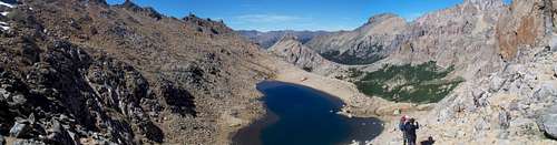 Laguna Schmoll Laguna Schmoll |
 Pico Bara Pico Bara |
GPS info and 3D map for Option 1 route above:
|
 3D route map for Option 1 (click to expand) 3D route map for Option 1 (click to expand) |
Other access routes:
The Frey area can be arrived at from Refugio San Martin / Jakob deeper into the Nahuel Huapi National Park. Jakob itself can be reached in one day from Tambo near western Bariloche or over 2 days via a tricky route starting at Colonia Suiza.
Climbing Routes
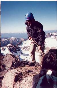
The Frey is a hotspot of outdoor recreation and a mecca for hiking and traditional/ sport climbing. Hikers usually link Refugio Frey with a series of other refugios in the area. Climbers tend to set up camp and enjoy the vertical surroundings. It features alpine granite at a leisurely pace. One can sleep in till 10 and still climb the tallest spire in the horizon and be back to enjoy the sunset with pizza and beer. The Frey offers a wide spectrum of climbing from the clean cracks to challenging heady sport to dirty cracks to chimneys to offwidths with each ending atop some precipitous spire with a view. [Chelsea]
For all the routes just go to: http://www.pataclimb.com/climbingareas/freycatedral.html It is a great site from Rolando Garibotti. [ricardo]
 Torre Principal (Nikman) Torre Principal (Nikman) |
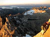 On Torre Principal (gringita511) On Torre Principal (gringita511) |
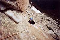 Aguja Frey (ricardo) Aguja Frey (ricardo) |
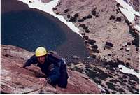 Aguja Frey (ricardo) Aguja Frey (ricardo) |
 Aguja Frey (ricardo) Aguja Frey (ricardo) |
Access routes to valleys 3D figure (click to expand)
If you wish to climb some of the more obscure spires bring cordelette and some bail gear to possibly build a rappel anchor. Many of the well traveled routes have new bolted rap anchors but one may be faced with a tattered piece of webbing slung around the summit block on some climbs. Otherwise a standard traditional rack along with two 60 meter ropes or double ropes is recommended. [Chelsea]
Bolted routes are very runout; we try to avoid them. Simple rack to #4 should be okay, there´s lots of fixed pitons. So far, except "Naka Naka Crunch Crunch", routes we did had bolted anchors with rings. Most climbs are 6a-6b but some starred 5 and 5+ we did were nice, wild and sandbagged. The "guidebook" is a bunch of topos for the spires. Imagination and patience are required to find route starts. [michalp]
Also see the attached Trip Reports, particularly this one, an epic 20 summit adventure.
Accommodation / Camping
Refugio Frey: (http://refugiofrey.com)
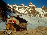
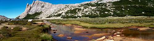
Refugio Frey sits at the end of a long shallow alpine lake and provides bunks and food. The home made pizzas, pastas, beer at night are great! There is usually a person running the refugio that can give you all the beta needed to climb. [Chelsea/ricardo]
If you want to sleep in the refugio you will need to arrange it beforehand by calling +54 9 2944 15330110. The fees for staying vary with type of room and other things thrown in. See this table for the current breakdown. The table also shows costs for use of various facilities, meals, drinks, learning programmes and guide services. Prices are in pesos.
Few other parties. At the hut dinner is 70 AR pesos and breakfast 25. You can cook using your stove for free (in the kitchen) and eat in the hut. Shower for 10 or splash in the lagoon (no soap allowed). [michalp, March 2010]
Camping: Camping, pit toilets, and a cooking shelter are available with no cost or permit requirement in the surrounding area of the refugio. In windy conditions utilize the rock bivy walls or shrubbery on the shoreline to set up camp. Then sit back and watch the countless adolescent scout tents fly away. [Chelsea]
Water: Drinking unfiltered water is not recommended even though this here gringa managed to survive a month of drinking from the cess pool with no complications. The water coming from the sink in the climbers cooking shelter is pumped from the outflow of the lake and should also be filtered. Along the south side of the lake there is a small pipe of spring fed water that would be more recommended to drink from. [Chelsea]
Regulations: No fires, but stoves are ok. Take all your trash with you including toilet paper. Stay on the paths. Respect plants and wildlife.
Downsides: Despite being the busiest area of a very busy national park in Argentina, the Frey has very few camping restrictions. Compared to National Parks in the USA there is a large amount of freedom with no trailhead quotas or camping regulations. Unfortunately this freedom is abused and slightly out of control at the Frey. While January is a most pleasant season to visit the area, be forewarned that it is also the Argentine summer break. The alpine basin will resemble a circus refugee camp of adolescent hiking groups that bathe, poop, and set up tents right on the lake shore. There are also a large amount of stray dogs that follow hikers up and prowl around to beg food and defecate everywhere. [Chelsea]
Upsides: The commute to Bariloche and back can be done in a day to stock up on food, check email, drink microbrews, eat ice-cream, etc....In other words one could live at the Frey indefinitely which is tempting. [Chelsea]
Other refugios: (may not be open all year)
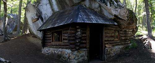
Refugio Piedritas
Refugio Piedritas: A small simple refugio/shelter on the way up to/down from Frey via the forest route. It's a basic wooden affair using a giant boulder for some of the walls and roof. There are no facilities or staff. Camping is permissible in the surrounding area.
Refugio Lynch: A refugio on the ridge above Villa Catedral, roughly halfway between Piedra del Condor and Punta Princessa at 2050 m altitude. Places to stay, food to eat etc. A ski lift runs up to it which operates for only part of the year.
Refugio San Martin / Jakob: A refugio deeper in the national park which can be a waypoint to/from the Frey area. This refugio is also accessible in one day from Tambo near western Bariloche. Breakfast, lunch, snacks and dinner available as well as overnight stays. Camping in the surrounds possible. Website: http://www.refugiojakob.com.ar/, Telephone: 02944 15323654.
Another 4-5 refugios and shelters as well as camping spots can be found around Cerro Lopez to the west, should you find yourself out that way.
Options in and around Bariloche:
Urban: Bariloche is the primary hub of the region as well as a tourist destination so has every kind of accommodation imaginable. This also extends to the villages that surround it. including Villa Catedral, Colonia Suiza, and Villa Los Coihues. Options range from camping to the enormous Hotel Llao Llao. A good local bus service means that access around the area is quick and easy.
Weather

Much of the area has little in terms of protection from the elements so come prepared in terms of knowledge, gear and clothing.
Weather can be a mixed bag but much sunshine can be expected during the (southern hemisphere) summer months. Winds can be fierce coming over the exposed saddle the refugio sits on. [Chelsea] The climbing season is probably November to April. You can find snow even in Dec to approach some of the spires. [ricardo] March weather is okay if you have patience: few days of sun then rain then again dry. [michalp]
During the southern hemisphere winter there's a different set of fun to be had, including lots of skiing and snowboarding potential throughout the area.
Weather forecast website Detailed weather charts for various altitudes and timeframes. An excellent resource. Also see the weather board and get the latest info from the folks in Club Andino Bariloche.
Resources and supplies
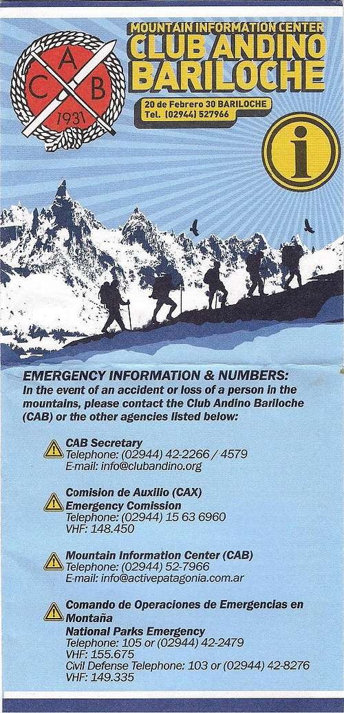
CAB leaflet
Climbing info:
There is a guide book for sale at the Club Andino in the town of Bariloche that gives a good briefing of the area and still leaves room for adventure. [Chelsea]
CLUB ANDINO BARILOCHE
Casilla de Correo 139. 20 de Febrero 30.
San Carlos de Bariloche - R. Negro
(02944) 42 2256/42 4531
Or you can order it from Rolando Garibotti - probably the best Argentine climber, who wrote it. I think his email is still rgaribotti@aol.com. [ricardo]
The "guidebook" is a bunch of topos for the spires. Imagination and patience are required to find route starts. [michalp]
This is a good place to get up to date climbing, trekking and weather info. Sometimes routes may be closed due to landslides so check before going. Also don't forget to register what you're up to (here or via link in Websites section).
Maps: Recommend visiting Club Andino Bariloche for a selection. The San Carlos de Bariloche one is excellent, with full colour, topography, marked routes etc. It extends 71°37'W-71°16'W and 41°2'S-41°13'S. There is a double-sided A4 print out map apparently issued by Refugio Frey showing various routes imposed on a 3D landscape. Due to some particular view angles, smoothed topography and some generalisations when it comes to route locations it can be a little misleading so while helpful for visualising perhaps don't rely on that exclusively if the weather's iffy.
The Lonely Planet - Trekking in the Patagonian Andes (various authors/editions) book also has some simpler maps in to accompany its trekking descriptions through this area, including to Frey, and beyond.
Emergency information and numbers: (in March 2011 at least)
CAB secretary: Tel. (02944) 42-2266 / 4579, Email info@clubandino.org
Comision de Auxilio (CAX) Emergency Comission: Tel. (02944) 15 63 6960, VHF 148.450
Mountain Information Centre (CAB): Tel. (02944) 52-7966, Email info@activepatagonia.com.ar
Comando de Operaciones de Emergencias en Montana, National Parks Emergency: Tel. 105 or (02944 42-2479), VHF 155.675
Civil Defence tel. 103 or (02944) 42-8276, VHF 149.335

Essential supplies
Supermarkets: There are 3 supermarkets that I know of in central Bariloche; 1) Perito Moreno, a few blocks from the square on your left 2) Av. Bartolome Mitre, a few blocks from the square on your right 3) Quaglia? - think this was the biggest one. Someone local will be able to help you.
Internet: A few places around but can recommend one on the first block of Av. Bartolome Mitre just east of the square, above a newsagent. Five pesos an hour, open till late.
Gear shops: There are a number of shops selling outdoor clothing and mountaineering equipment. These are almost all (to my knowledge) along Av. Bartolome Mitre in the town centre. There's one around 8 blocks or so past the rest on the left hand side which also sells second-hand kit. As I recall like most places it was closed on Sundays and open only until midday on Saturdays. There are also some in Villa Catedral but may be more prone to opening during the ski season, not sure.
Websites: (from throughout this page + others)
http://www.nahuelhuapi.gov.ar - Trekking registration (officially mandatory).
http://www.stonedance.com/ - Rock climbing in Argentina and Chile. [Chelsea]
http://www.pataclimb.com/climbingareas/freycatedral.html - Climbing route site by Rolando Garibotti. [ricardo]
http://www.snow-forecast.com/resorts/Catedral/ Detailed weather charts for various altitudes and timeframes. An excellent resource.
Nearby climbs
Multi-day:
Nahuel Huapi 3/4/5 day Traverse: A backpacking trek through the mountainous scenery of the Nahuel Huapi National Park, between Villa Catedral on in the east and Puente Lopez in the west. While the whole route is ~37 km and generally done in 4 to 5 days there are several variations in terms of alternative finishes allowing for curtailed trips in the event of time limitations or bad conditions. All sections can be exited within one day. A visit to Refugio Frey is traditionally the end of the first day, Refugio San Martin / Jakob the second, Refugio Segre / Italia the third and Refugio Lopez for the fourth. The section between Jakob and Italia involves scrambling and best for those with experience and only in good weather. Some maps indicate there is an alternative work around though via a valley and a mountain pass. The Lonely Planet - Trekking in the Patagonian Andes (various authors/editions) covers the route well though there may be alternative guides out there.
Day trips:
There are a number of climbs that can be done in a day from Bariloche, including as a combination. Access to these can be done via local buses, by bike or just on foot.
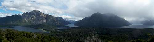
View from Cerro Campanario
Cerro Campanario (1022 m): A sub-hour hike up from the road provides some spectacular views (free). Or you can take a chair lift ($$). There's also a restaurant with big windows for staring out of while eating cake. Take a bus bound for Llao Llao and get off around Km 17. The entrance is fairly grand so you can't really miss it and a dozen other people will get off the bus with you. The trail head is essentially a little ways to your left when you're staring at the price list in the ticket office.
View from Cerrito Llao Llao
Cerrito Llao Llao (1014 m): A nice hike up this hill in the Parque Municipal on the Llao Llao Peninsula provides a serene atmosphere and great views from various points once you gain some height. A side path leads to Bahia and Puerto Llao Llao. You can walk here relatively easily from Hotel Llao Llao which is a turn around point for some buses. There are some other walks in the parks nearby.
Cerro Otto (1380 m): A climb right by Bariloche with a revolving restaurant at the top. Or you can get a shuttle to the top from town. I hear the views are great. To hike there initially follow these instructions form the CAB brochure: "The road leading to the summit of Cerro Otto begins opposite the gas station located at the Km1 of Av. de los Pioneros. 100 m to the left begins a walking and biking trail which later links up with the road near the top. You will pass the winter activities centre Piedras Blancas 1km before reaching the shelter [Refugio Berghof at 1259 m]" Then carry on along the road to the summit.
Cerro Negro (1970 m): A peak in the national park, accessed from Colonia Suiza with a long approach via a valley then a steep climb. See here for some photos and a map.
Cerro Lopez (2188 m):
Videos
Some videos from the area:
Orig. Cerro Catedral climbers log
In case the old page suddenly gets deleted.
Vinny Awesome place
Fun times and my first time hiring a guide (we had no rock gear). Neat Rock- I'd love to go back! We cragged rather than summited. Bicho was great and showed Robin and I a good time. If I remember correctly this was the start of the Nahuel Huapi traverse for several days.
Posted May 27, 2010 4:41 pm
William Marler Date Climbed: January 1996
Followed a trail to the high point overlooking the lake. Followed other trails into lush forests on the backside. I have photos somewhere and will post. Beautiful spot. Cheers William
Posted May 25, 2004 11:40 am
ricardoRoute Climbed: Normal Date Climbed: December 2001
To my surprise the summit metal box had no book inside but a bunch of papers left by some other climbers. When I opened it a bunch of those flew away... Didn't even bother to leave anything. I think the original summit book is in the CAB (Club Andino Bariloche)
Posted Nov 24, 2003 4:10 pm
Unused text
There is also an option to take an overpriced ski lift ride up Cerro Catedral and then traverse and hike down to the Frey. [Chelsea]
While there are three main trails to the Frey, it is recommended to take the trail that starts at Cerro Catedral and contours around the ski area then straight up into the Frey. It is a dusty 10 km hike with a lot of traffic but goes very fast. [Chelsea]
From the Cerro Catedral Ski Parking lot you will see the sign to the trail that will take you up to the "Refugio Frey" it is a 10 kilometer trail that you can do in 4 hours. Just follow the signs...you cant miss it. [ricardo]
The trail coming from Lake Gutierrez adds a good amount of extra vertical and sun exposure and not recommended unless one wants to swim. [Chelsea]
Camping is allowed - If not you can still sleep at the hut. (refugio frey http://refugiofrey.com.ar) If you are going during the summer call the CLUB ANDINO to make sure there is not a big group. [ricardo]
michalp - Mar 22, 2010 10:12 am - Hasn't voted
The ClimbsWe were climbing at Frey few days ago (mid-March). We took a week of food, teleferico (lift, 40 AR pesos one way) and the high route. It was beautiful (panoramic views on Andes) but strenuous (scrambling on big boulders) and partly unmarked (we followed yellow poles up from the last lift). With even more food or bad weather it´s probably better to take lower 4h hike uphill. Bolted routes are very runout; we try to avoid them. Simple rack to #4 should be okay, there´s lots of fixed pitons. So far, except "Naka Naka Crunch Crunch", routes we did had bolted anchors with rings. Most climbs are 6a-6b but some starred 5 and 5+ we did were nice, wild and sandbagged. The "guidebook" is a bunch of topos for the spires. Imagination and patience are required to find route starts. March weather is okay if you have patience: few days of sun then rain then again dry. Few other parties. At the hut dinner is 70 AR pesos and breakfast 25. You can cook using your stove for free (in the kitchen) and eat in the hut. Shower for 10 or splash in the lagoon (no soap allowed).