-
 5783 Hits
-
 88.19% Score
-
 26 Votes
|
|
Route |
|---|---|
|
|
47.05027°N / 11.83778°E |
|
|
Mountaineering, Trad Climbing |
|
|
Summer |
|
|
Most of a day |
|
|
UIAA V |
|
|
Overview
Zsigmondyspitze South-East Ridge
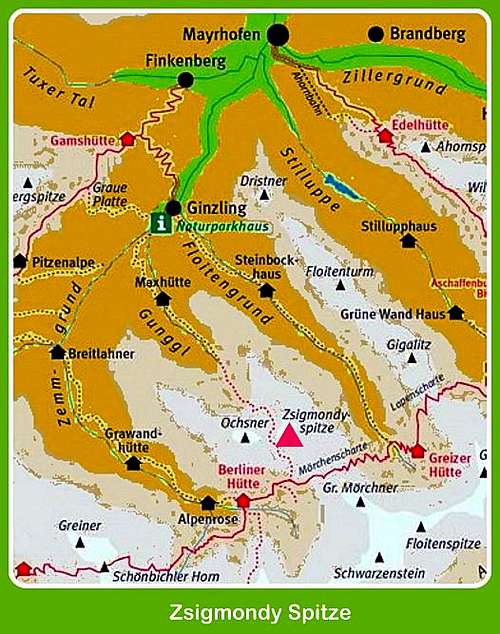
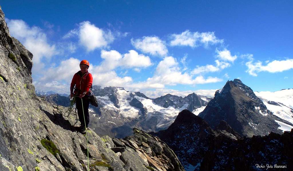
Zsigmondyspitze 3089 m is a high, magnificent and steep granite peak lying in the middle of the Zillertal Alps, in the Austrian county of Tyrol, nearby to Rosskopf, Mörchnerschartenkopf and Rotkopf. It is regarded as the most famous climbing mountain of the Zillertal Alps. Due to its central and main ridge upstream position, the views from the summit are very impressive. The climbing tour on the Zsigmondyspitze is an alpine granite rock classic in the Zillertal. The high-alpine landscape makes this tour a wonderful experience. Due to its shape, Zsigmondyspitze is also called the Matterhorn of Zillertal, even if much smaller than the true Matterhorn.
It's a mountain that holds a special meaning for me, I can't understand why ... maybe the main reason can be traced back to the old book by Walter Pause "100 classic climbs", nowadays become historic. It was one of the first mountaineering books to enter my library, so i wished to climb this peak by countless years, enchanted by its shape, and in addition I was willing to stay once overnight in the famous Berliner Hütte. Without any particular reason, although Austria is neighboring and bordering Italy, I had never climbed there during my climbing career before the summer 2016.
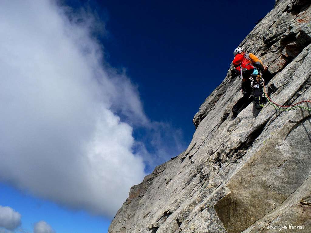
On September 2016, found the information needed to access and approach, as well as the report of the climb, the time came to summit this beautiful peak, with the complicity of a week's holiday with exceptionally favorable weather. Still it was not sure, but my intention wasn't to climb the Normal route, but the direct South Ridge.


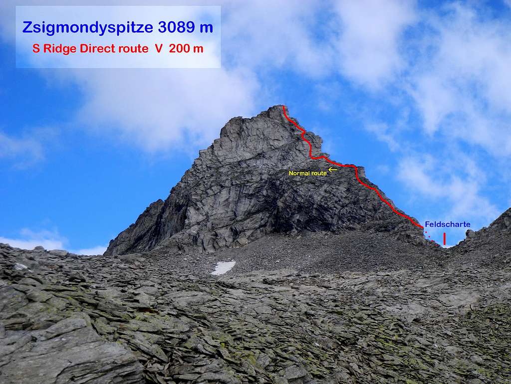
This route starts together with the Normal one, but while this latter performs a long deviation to the left in order to avoid the steeper and more difficult stretch along the ridge, the Direct route overcomes the most difficult terrain on the edge, opposing a brief move grading V UIAA.
Getting There
The nearest resort is Mayrhofen 630 m, a small town surrounded by countless peaks near the border with the Ahrntal in South Tyrol, Italy.
Road access
Coming from Italy - From Bolzano take A22 Brennero highway towards Brennero. After the pass you are in North Tyrol, go on towards Innsbruck and from there take the A13, exit Jenbach and take the Zillertal road n. 169 to Fügen, Zell am Ziller and Mayrhofen. In Mayrhofen continue on the road 169 to Ginzling (Guest House Breitlahner, paying parking). The starting point for the hike is the Gasthof Breitlahner in Ginzling, where there is also the Naturparkhaus center. The resort can be reached by the bus line 4102 or by car. Parking in Breitlahner is charged.


Walking approach to Berliner Hütte
From the Gasthof Breitlahner take the trail 523, which runs along the long Zemmgrund Valley. After a short steep stretch, the path enters the valley and after a mainly flat part, it slowly starts to go up, passing near the Klausenalm and Schwemmalm alps, then near the Grawandhütte refuge and the Alpenrose Hütte.


Soon after this latter hut, the path head to left and after the "Memorial to the fallen soldiers" gets the refuge Berliner Hütte at 2042 m. 3-4 hours from Breitlahner.
History

Emil Zsigmondy
Zsigmondyspitze, originally called Feldkopf, is a summit dedicated to the intrepid Austrian mountaineer Emil Zsigmondy, Hungarian-born. The two Zsigmondy brothers, Emil and Otto, did the first ascent of this peak in 1879. Zsigmondy was an excellent alpinist, starting his career as a teenager, climbing the Reisseck in Austria with his brother. By the late 1870s the two brothers were climbing without guides in the Zillertal Alps. In 1881, they climbed the Ortler from the Hochjoch. Emil Zsigmondy was also the friend and companion of Ludwig Purtscheller, the great pioneer of guideless Alpine climbing. The two brothers climbed with Purtscheller in 1882 and 1884, including an ascent without guides of the Marinelli Couloir on Monte Rosa and the first guideless traverse of the Matterhorn. Zsigmondy's outstanding achievements include the first ascent by the East arête of the Meije in the Massif des Écrins, made with his brother and Purtscheller in the year 1885. A few days later he died on the same mountain. He was killed in an attempt to climb the south face of the Meije on 6 August 1885. This difficult face was successively won in 1912 by Angelo Dibona and Luigi Rizzi with the brothers Guido and Max Mayer. Emil Zsigmondy's grave is located a few miles away from the accident site, in the small cemetery of Saint-Christophe-en-Oisans in the Dauphiné Alps. More info: Angelo Elli
Route Description
Zsigmondyspitze South-East Ridge - UIAA scale
Summit altitude: 3089 m
Difficulty: V max (UIAA)
Vertical gain: 200 m
Exposure: South
Starting point: Berliner Hütte
First ascent: H. Fiechtl, H. Hotter 1911
A beautiful and satisfactory direct line, named Südostgrat in German, located on the right to the Normal route, involving a pitch grading V UIAA with only a few pegs. It is possible to abseil the most difficult parts of the route.


Approach from Berliner Hütte - The starting point to climb is the col named Feldscharte 2909 m, between Zsigmondyspitze and Roßköpfe. From the Berliner Hütte take the trail n. 502 towards Greizer Hütte (it's a part of the Berliner Höhenweg), getting the nice Schwarzsee in about 1 hour. Leave the path n. 502 and take now the marked path 522, starting to rise to saddle Melkerscharte 2814 m. After passing another little lake and about 100 m before getting the Melkerscharte leave the main trail and exit rightward rising up along scree and snow-fields in the direction of the Feldscharte. The starting point is just from the col.
Route report
L1 - Climb up directly near the edge climbing a nice wall cut by some cracks, III, 35 m belay to be equipped.
L2 - Continue up the ridge on easier rock, belay on an outcrop II, 40 m.
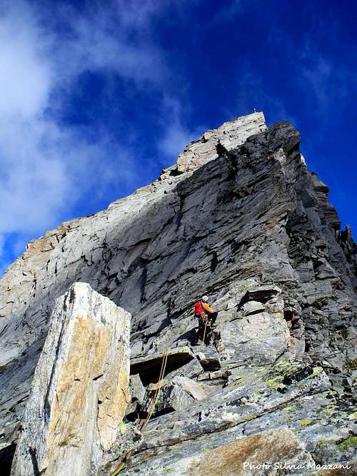
L3 - While the normal route deflects sharply left with a very long traverse, we will continue on the edge of the ridge in the direction of the vertical wall that characterizes the central part of the edge. Equipped belay under the steep wall, III, IV, 40 m
L4 - The crux pitch. From the stance head slighty left to reach the wall, climb straightly the first vertical move, then continue along dihedral and cracks slanting left, reaching an equipped belay above the wall, V, 35 m.
L5 - Bypass a huge boulder on the left and go back to the edge. Belay inside a notch on the edge, II, 30 m
L6 - From the notch climb up directly on the ridge of the upper spur on fine rock to an equipped belay under the final wall, III, 25 m.
L7 - Up the crackline directly above the belay, then slanting left to climb the direct variant on beautiful flakes leading directly near the summit cross or, easier but less pleasant, from the exit of the corner up to the right on a rock-gully to a shoulder behind the summit, then to the summit. IV the direct variant, otherwise II, 30 m.
Climbing last flakes before the summit |
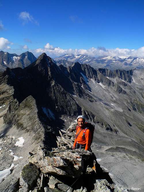
Summit crest |
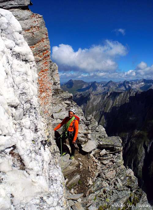
Descent ledge |
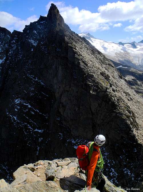
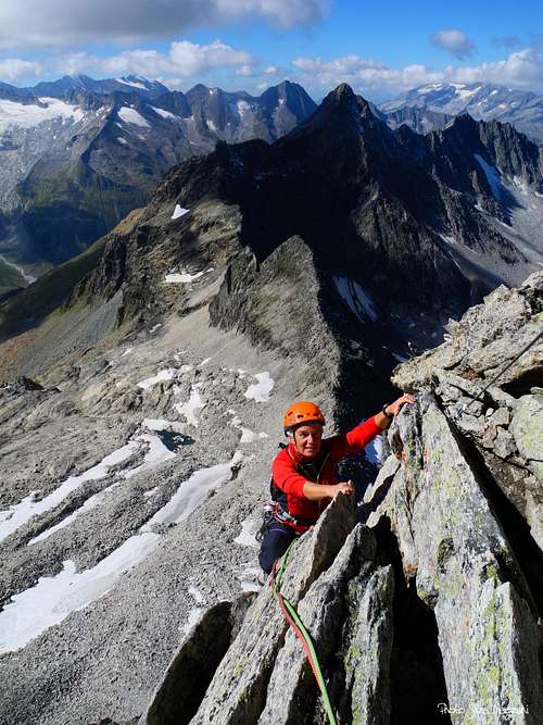
Breathtaking views on the ridge |
Descent - reversing the route, abseiling along the steeper pitches and downclimbing where possible
Essential Gear
Ropes 2x50, helmet and harness, some quickdraws, slings. There's no need of ice-tool in normal conditions.
Zsigmondyspitze views


Red Tape

No permit no fees required to climb and no red tapes in the Zillertal Alps. Anyhow this zone of Alps is a natural reserve ("Ruhegebiet Zillertaler Hauptkamm") with some limitations.
Hut
Berliner Hütte 2042 m DAV Sektion Berlin is an imposing mountain refuge
Situation: Schwarzensteinalm in the upper Zemmgrund
Owner: DAV Sektion Berlin
Guardian: Rupert Bürgler
Open: 15 of June - 30 of September
Size: 177 persons + 14 in the winter-shelter
Email: berlinerhuette@aon.at
Hut's phone: 0043 676 7051473
Getting There: from Gasthof Breitlahner in Ginzling in 3-4 hours
|
Alpenrose Hütte |
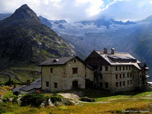
Berliner Hütte |
Alpenrosen Hütte 1878 m
Situation: upper Zemmgrund
Guardian: Franz Joseph Fleckl
Email: alpenrose@ginzling.com
Mobile 0043/(0)664/ 9177850
When to climb
Best season is from July to September
Guidebooks and maps