An Unspeakable Day in the Wasatch Mountains: Photo Trip Report.

An Unspeakable Day in the Wasatch Mountains: Photo Trip Report.

Page Type Page Type: Trip Report
Location Lat/Lon: 40.58997°N / 111.67053°W
Date Date Climbed/Hiked: Mar 22, 2008
Activities Activities: Mountaineering
Seasons Season: Spring, Winter

South Ridge, Mt. Superior, Utah

Considered a Wasatch classic climb, the south ridge of Mt. Superior lies directly north of the Snowbird Ski Resort. In the summer, the south ridge is a spectacular climb, which is mostly 4th class and a few sections of low 5th class rated at 5.3. Under snow cover, the route becomes more challenging as you climb 55-60 degree snow, negotiate cornices that swallow the ridge proper, and search diligently for good protection. Overall the ridge is a magnificent climb in superb surroundings. This one comes highly recommended!

Climbers:
Glenn
Levi
Matt
Michael


Here come the photos...

South Ridge, Mount Superior, Utah
Our ascent up the south ridge and descent down the south face of Mount Superior.

South Ridge, Mount Superior, Utah
Glenn enjoying the sunrise on the lower slopes of the south ridge. The majority of the initial slope is between 30-40 degrees. As the slopes funnels to create the first narrow section of ridge, the slope max is roughly 50-55 degrees.

South Ridge, Mount Superior, Utah
Atop the initial slope, we gained our first view of the majority of our route.

South Ridge, Mount Superior, Utah
Exposed sections of the ridge, which are quite comfortable in the summer, become more unnerving as cornices swallow up the real estate. We attempted to chop a hole in this cornice, but the snow and ice was rock solid.

South Ridge, Mount Superior, Utah
Looking down the first narrow section of ridge, with a beautiful cornice peeling over the east side.

South Ridge, Mount Superior, Utah
The final section of the first narrow ridge on the south ridge route. This section of ridge ends at the top of the Suicide Chute. With some exposed rocks and horns we could have used a running belay, but with all this snow, the rope would only assure that we all died together in a fall, so we kept the rope coiled away.

South Ridge, Mount Superior, Utah
The view up the middle section of the south ridge as seen from the top of the Suicide Chute. This was a great spot for a rest.

South Ridge, Mount Superior, Utah
Above the Suicide Chute was a 60-degree slope that I didn't bother to take a photo of. I just wanted to climb up it fast. After that fun, we got back to narrow ridge lines.

South Ridge, Mount Superior, Utah
Along the entire route there was so much snow that protection was few and far between. This was the best belay all day.

South Ridge, Mount Superior, Utah
A nice mild section of climbing just over midway up the route. On these broad sections of the ridge the snow was a bit soft, but still powdery so trailbreaking wasn't too hard.

South Ridge, Mount Superior, Utah
This was the first really exposed move on the route. Although the camera doesn't show it too well, the rocky areas in the middle of the photo required some of those full-commitment moves. Glenn found some good protection by wrapping a sling around an ice column under the overhanging rock.

South Ridge, Mount Superior, Utah
A close up of some of the huge cornices.

South Ridge, Mount Superior, Utah
Other than the tree belay shown earlier, the rest of the climb was boot/axe belays and the like.

South Ridge, Mount Superior, Utah
The last section of exposed climbing on the south ridge. Again, the camera doesn't do this justice. Before Glenn placed his steps, this was a thin fin of sugary snow and it was very hard to tell where the rock ended and the cornice began. Although we all pulled our share of leading, Glenn took the two most difficult sections, which earned him the "balls of steel" award. It was some fine climbing.

South Ridge, Mount Superior, Utah
After the last exposed section of ridge, it was time to relax and coil the rope. What a climb this was turning out to be!

South Ridge, Mount Superior, Utah
Taking the last section of the ridge to the summit. Most of the south ridge is visible below.

South Ridge, Mount Superior, Utah
The summit of Mt. Superior with Monte Cristo in the background. Days like this make you pinch yourself to assure it's real.

South Ridge, Mount Superior, Utah
Traditionally we would walk down the east ridge route, but with the stable snow, how can you resist a glissade down the south face of Superior? During our climb, we watched three groups of skiers put lines down the south face, so we decided to join 'em.

South Ridge, Mount Superior, Utah
In the soft snow we could only glissade so far, the rest was postholing...fun. I swear my hips and thighs nearing exploded by the time we reached the road below.

Conclusion

How would we sum up the day? Unspeakable! Great partners, stable snow, perfect weather and spectacular surroundings. Ah, the mountains, it doesn't get any better.


Comments

Post a Comment
Viewing: 21-30 of 30
12

marauders - Oct 9, 2008 1:18 am - Hasn't voted

Re: Picks up jaw off floor...

Thanks for the kind remarks. Can you believe this stuff is in our backyards? Ridiculously good! We are making this an annual climb; it was that fun. You're welcome to join when the details are posted on SP in February or March.

WildOne

WildOne - Jan 16, 2009 3:44 pm - Voted 10/10

SICK

TR! Been OOHING and AWWWING over Superior for years now and have yet to even make an attempt at climbing it. Thanks for posting this. Don't know if I missed it, but do you remember the overall trip time for this one? I'll be back home for a few weeks next winter and hope to do some of the long desired climbs.
Thanks!

marauders - Jan 21, 2009 4:46 pm - Hasn't voted
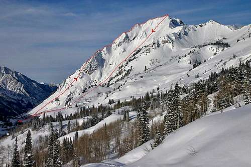
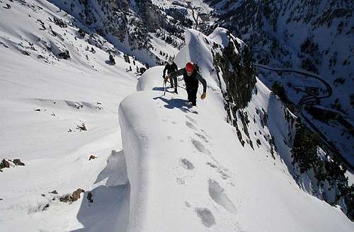
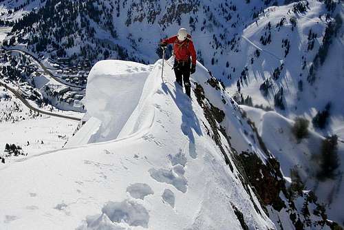
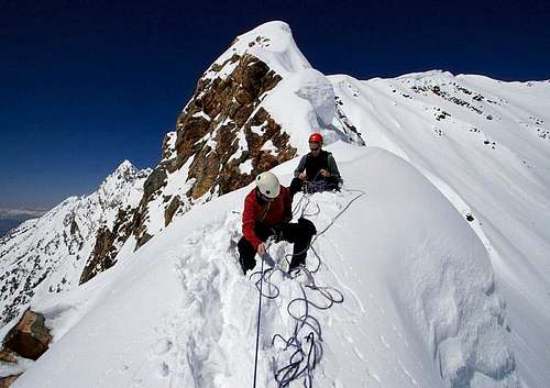
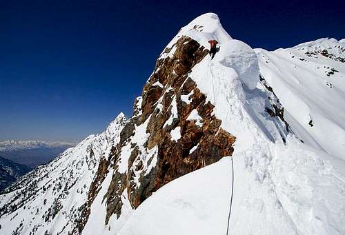
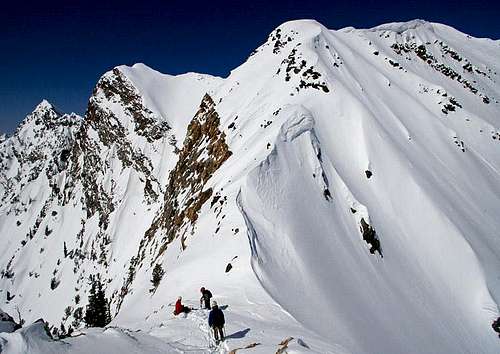
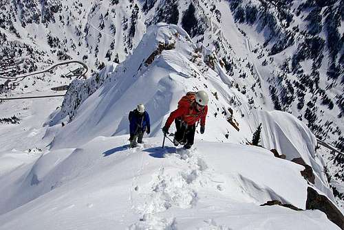
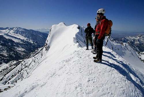
Re: SICK

The less technical East Ridge is probably 4.5 hours to summit. The more technical South Ridge is probably 7 hours to summit. We glissaded down the south face for descent and that probably took another 1.5 hours.

asaking11

asaking11 - Jun 8, 2009 3:36 am - Voted 10/10

Awesome Pics

What a great collection of amazing pictures.

marauders - Jun 8, 2009 2:13 pm - Hasn't voted

Re: Awesome Pics

Thanks!

phatty

phatty - Aug 27, 2009 4:58 pm - Voted 10/10
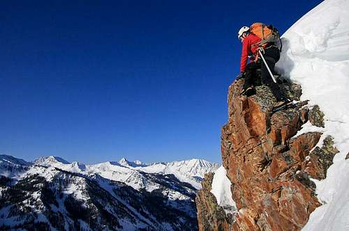
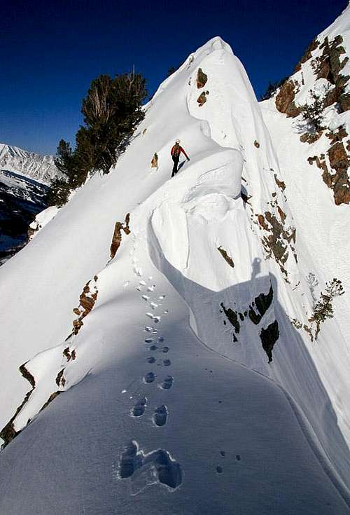
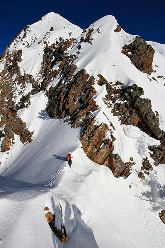
SAWEEEET!

SICK climb! Having been up to superior a variety of different ways I can say that this route you did is just crazy! (in a good way of course!) Nice job with the pics to show exposure and commitments!

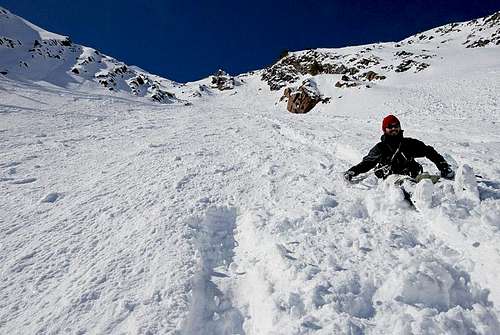
I have a picture somewhere of me and my snowmobile parked on the peak of superior... see if i can find it... that was a crazy ride down! (cardiac bowl)

marauders - Aug 27, 2009 7:19 pm - Hasn't voted

Re: SAWEEEET!

Woah! Cardiac Bowl on a snowmobile! I have a hard enough time skiing it, let alone snowmobiling it. I'd love to see the pic.

loulan - Nov 12, 2010 1:53 am - Hasn't voted

fg

google
google
[url=http://www.google.com]google[/url]

theoutdoordude - Sep 3, 2012 1:11 pm - Hasn't voted

Amazing

I'm planning a trip out to Utah around the 1st of October and this makes me want to come even more. Granted there won't be this much snow. Can't wait. Awesome pictures.

marauders - Sep 3, 2012 1:35 pm - Hasn't voted

Re: Amazing

In October, there likely won't be much snow at all, but the fall colors will be in peak form!

Viewing: 21-30 of 30
12

Parents 

Parents

Parents refers to a larger category under which an object falls. For example, theAconcagua mountain page has the 'Aconcagua Group' and the 'Seven Summits' asparents and is a parent itself to many routes, photos, and Trip Reports.