
-
 15016 Hits
-
 84.82% Score
-
 19 Votes
|
|
Mountain/Rock |
|---|---|
|
|
36.86751°N / 3.89044°W |
|
|
Hiking |
|
|
Spring, Summer, Fall, Winter |
|
|
5837 ft / 1779 m |
|
|
Overview
 Cerro Lucero seen from Puerto Llano Cerro Lucero seen from Puerto Llano |
Cerro Lucero, or Cerro de los Moriscos is a mid-sized mountain in Andalucia. It located in the north of Sierra de Almijara, one of the southernmost mountain ranges of the country, which stretches north of the Andalusian coast between Velez Málaga and Almuñécar and which cuts off the coast from the plains between Alhama and Granada. The range is made up from limestone and marble, a fact, which is only visible near the mountain tops and inside some of the profound canyon-like barrancos which cut into the range from the south. Everything else is hidden beneath thick layers of vegetation - pine forests and macchia-like bushes.
Lucero is a remote mountain - the routes from Competa or Canillas de Albaida in the east take 6h to complete one way. Climbing the mountain from one of these villages, or even performing the loop hike Competo - Lucero - Canillas takes a very longish to complete. It is a 30km affair with an elevation gain of almost 2000m! On the other hand - if you know your ways on the dirt roads, which run through the Sierra, you can make use of a access road which used to serve a marble quarry at the eastern base of the mountain buut which is out of operation nowadays. From this "trailhead" the climb doesn't take more than two hours. However, in principle the roads are closed to anyone except forestry workers or the rangers of the natural park, which encompasses the Sierra. Therefore most aspirants actually take the long road.
|


Like many of the mountains of the range, Lucero has a somewhat infamous history. During the Franco era it served as a lookout for the Guardia Civil, tried to hunt down partisans. There remains - on the very top of the mountain - a lookout cabin, or what is left over from the time. The two walls nowadays serve as little more than protection agains the westerly winds which often can be very fierce in this region.
Our own climb of the mountain ended in a near whiteout on top. Still the little we were able to see appeared to be rather impressive. The close-up views of the main ridge of Sierra de Almijara are among my most cherished reminiscenses of the climb. To the north the wide plains of Alhama and Granada can be seen. Also both of the ascent routes - which we did as a loop hike are memorable. When hiked in spring you run across countless numbers of wildflowers, which grow out of the cracks in the limestone rock.
|


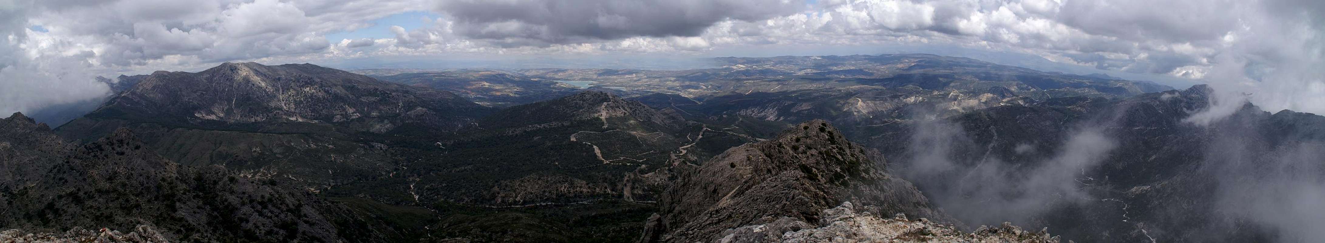
Summit Panorama
  |
Getting There
 Puerto Llano with the ascent route
The closest airport is at Malaga. To reach the trailheads at Competa or Canillas de Albaida proceed as follows:
- From the airport head eastwards towards motorway A7
- Take the motorway northward around Malaga
- At Los Granadinos stay on A7 which turns eastwards, direction Motril
- At Velez Malaga - rather the exit thereafter, Caleta de Velez - turn onto A6203, direction Competa.
- Either stay at the village or take the side road to neighbouring Canillas de Albaida and onwards to the picnic area Fábrica de Luz.
Red Tape
 Wild pigs during the ascent to Lucero
Cerro Lucero like all of the surrounding mountains belongs to the Parque Natural de las Sierras de Tejeda, Alhama y Almijara. The usual restrictions apply. The ranges are used for farming and mining so you are free to use the web of dirt roads which covers them. Aside the roads you are requested to stay on the trails, which generally are well maintained.
Especially in spring the lower ranges are covered with millions of wild flowers. Please leave them in their places. Also, in the higher areas you are bound to find herds of Iberian Ibexes. The animals, especially the males, are so used to visitors that you can barely disturb them.
Accommodation
The Costa de la Sol is one of Europe's major vacation getaways and there are all types of accommodation to be found. Hotels, apartments, fincas can be booked from any tourist office all over Europe and there are many sites on the net which deal with the area.The closest towns Are Vélez Málaga and Nerja, 10km to the south-west and south-east of the trailhead. You can find all types of accommodation there.
Weather Conditions
 The ascent route from Puerto Llano
Maps & Books
There is a good map of Sierra de Almijara, which, however, is hard to come by.- Sierra de Almijara Mapa Topographico
Editor: Miguel Angel Torres Delgado
1:25000
ISBN: 978-6-99-000430-3
As guidebook I can recommend the following one which is available in German and English
- Andalucia South / Andalusien Süd
Costa del Sol – Costa de la Luz – Sierra Nevada
Bernhard Plikat (translation: Gill Round)
Rother Verlag
ISBN 978-3-7633-4824-4 (English)
ISBN 978-3-7633-4147-4 (German)