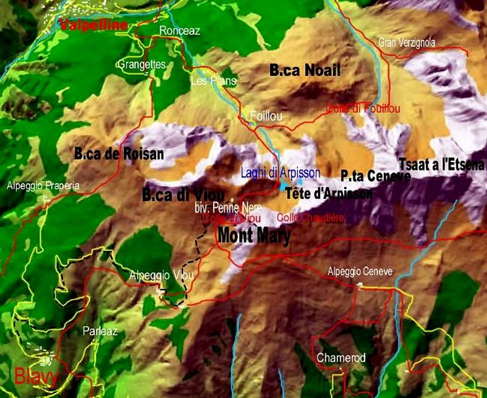
This valley actually a gorge below the two Summits of Tsaat à l'Estena
(2.973 / 5 meters about) and to the neighboring Becchi di Fana
(2.951m) , as well as above the built-up area of Municipality of Quart
(906m) , located on the Northern shore of the Media Aosta Valley, is located on the slopes of the vast and elongated Senevé or Cénevé Basin, dominated by the homonymous and restored pasture
(2.199m). The same originates from the slopes of the broad moraine that wraps the watershed ridge at the base from Mont Mary to the East
(2.815 m) up to the Western ante Summit
(2.945m) of the various Becchi di Fana which, seven in number, appear as you descend towards the adjacent Comba Dèche, small basin always in Quart Municipality and adjacent to the Saint Barthélemy Valley. A very precipitous descent that originates from Alpe Chavod
(2.038 m) with Torrent Florencière on the Western branch of the Canyon, while on the opposite side, below Alpe Latta or Lattaz
(2.000 meters approximately) the Torrent du Château de Quart descends. The two torrential branches come together, leaving at the top the clearing of Planes Pastures
(1.551m) and the Alps of Chamerod to the West
(1.614m), Vernier
(1.562m ) in the middle, Rapailles
(1.528m), as well as near the rocky-wooden promontory of Alpe Sechot
(1.408m) giving life to a single very steep gorge. Beyond, after leaving the Borelly Alps
(1.483 m), Ayette
(about 1.450 meters) and Praillon
(1.262m) in the upper West, all sprayed just above by the
"Ru de Vernier", collects at an altitude of
1.222 meters the waters of some secondary streams coming from the Eastern Slpes of the large and elongated Summit of the Croix de Fana
( 2.212m) , with which the buttress begins to decline above the
Valseinte with its Pastures
(1.399m) overlying the
Saint Emeric's Oratory (1.137 m) and towards Southeast over the three separated Hamlets of Trois Villes
(Highest of Fonteil 1.423m, Avisod intermediate Village, 1.398m, lower of Porsan 1.299m). The gorge ends, before joining the Dora Baltea, flanking the Quart Castle
(774m) near the Hamlet of Villair de Quart
(632m). From this point, after having wedged itself between high rocky walls and passing the Hamlets of Villair and the opposite in East of Josué Fraction
(671m), the stream extends towards the plain of the Dora Baltea into the Aosta Central Valley. Starting from a castle built over a very ancient settlement, certainly by the
Celtic-Salasse tribes. Before the arrival of the Romans.
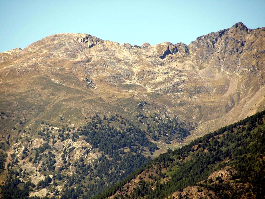
![]() Middle sector of Château de Quart Ravine under Senevé also Cénevé Basin.
by Osw December 2015
Middle sector of Château de Quart Ravine under Senevé also Cénevé Basin.
by Osw December 2015
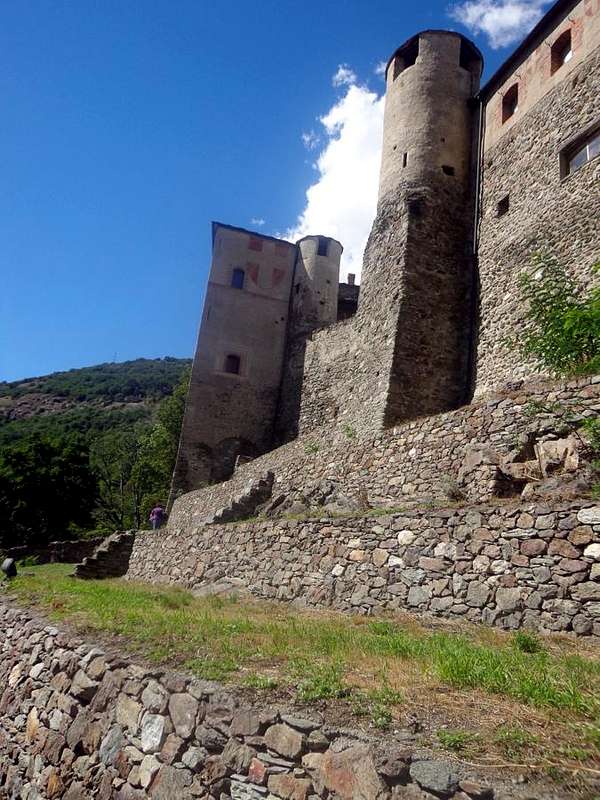
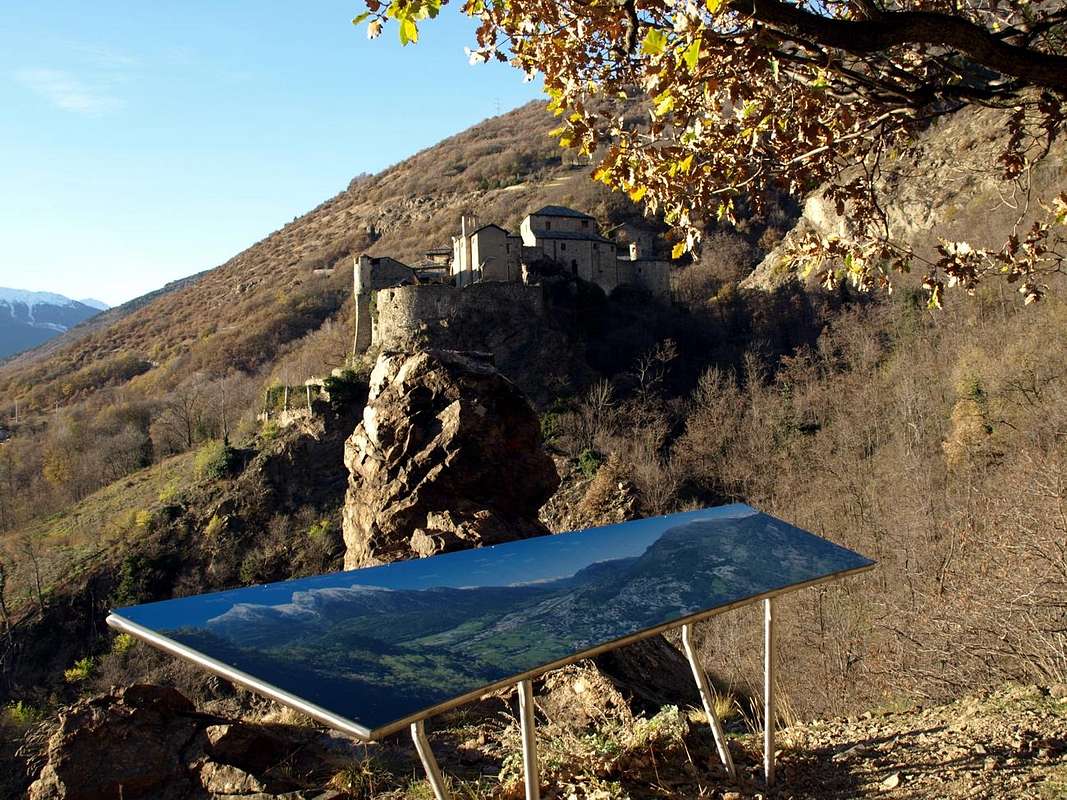
![]() Lower sector of Château de Quart Gorge, just neighbor the homonym Castle and above Villair de Quart Hamlet.
by Osw May 2017
Questo vallone in realtà é una gorgia sottostante le due Sommità della Tsaat à l'Estena (2.973 / 75 metri circa) ed ai viciniori Becchi di Fana (2.951 m), nonché al di sopra dell'abitato del Comune di Quart (906 m), situato sulla sponda Settentrionale della Media Valle d'Aosta, é collocato alle pendici del vasto ed allungato Bacino di Senevé o di Cénevé sul quale domina l'omonimo e ristrutturato alpeggio (2.199 m). Lo stesso trae origine alle pendici della larga morena che fascia alla base la cresta spartiacque dal Mont Mary ad Oriente (2.815 m) fino all'antecima Ovest (2.945 m) dei vari Becchi di Fana che, in numero di sette, si profilano scendendo verso l'attigua Comba Dèche nella Valle di Saint Barthélemy. Una discesa precipitevolissima che trae origine dall'Alpe Chavod (2.038 m) con il Torrent Florencière sul ramo Occidentale del Canyon, mentre dal lato opposto, al di sotto dell'Alpe Latta o Lattaz (2.000 metri circa) scende il Torrent du Château de Quart. I due rami torrentizi si riuniscono, lasciando in alto la radura di Les Planes (1.551 m) e le Alpi di Chamerod ad Ovest (1.614 m), Vernier em>(1.562 m)nel mezzo, Rapailles em>(1.528 m), nonché presso il promontorio dell'Alpe Sechot (1.408 m) dando vita ad un'unica ripidissima gorgia. Oltre, dopo aver lasciato in alto ad Occidente le Alpi di Borelly (1.483 m), Ayette (1.450 metri circa) e Praillon (1.262 m), tutte irrorate dal "Ru de Vernier", raccoglie a quota 1.222 metri le acque di alcuni rivi secondari provenienti da Est dalla larga Sommità della Croix de Fana (2.212 m), con la quale il contrafforte inizia a declinare sopra la Valseinte con i suoi Alpeggi (1.399 m) soprastanti l'Oratoire de Saint Emeric (1.137 m) e verso Sudest al di sopra delle tre distinte Frazioni di Trois Villes (Superiore di Fonteil 1.423m, il Villaggio intermedio di Avisod 1.398 m, inferiore di Porsan 1.299m). La gola termina, prima di confluire nella Dora Baltea, fiancheggiando il Castello di Quart (774 m) nei pressi della Frazione del Villair de Quart (632 m). Da questo punto, dopo essersi incuneato tra alte pareti rocciose e superate le Frazione del Villair e di Josué, il torrente si distende verso la piana della Dora Baltea. Partendo da un castello costruito sopra un antichissimo insediamento, sicuramente ad opera delle tribù Celtico-Salasse. Prima dell'arrivo dei Romani.
Lower sector of Château de Quart Gorge, just neighbor the homonym Castle and above Villair de Quart Hamlet.
by Osw May 2017
Questo vallone in realtà é una gorgia sottostante le due Sommità della Tsaat à l'Estena (2.973 / 75 metri circa) ed ai viciniori Becchi di Fana (2.951 m), nonché al di sopra dell'abitato del Comune di Quart (906 m), situato sulla sponda Settentrionale della Media Valle d'Aosta, é collocato alle pendici del vasto ed allungato Bacino di Senevé o di Cénevé sul quale domina l'omonimo e ristrutturato alpeggio (2.199 m). Lo stesso trae origine alle pendici della larga morena che fascia alla base la cresta spartiacque dal Mont Mary ad Oriente (2.815 m) fino all'antecima Ovest (2.945 m) dei vari Becchi di Fana che, in numero di sette, si profilano scendendo verso l'attigua Comba Dèche nella Valle di Saint Barthélemy. Una discesa precipitevolissima che trae origine dall'Alpe Chavod (2.038 m) con il Torrent Florencière sul ramo Occidentale del Canyon, mentre dal lato opposto, al di sotto dell'Alpe Latta o Lattaz (2.000 metri circa) scende il Torrent du Château de Quart. I due rami torrentizi si riuniscono, lasciando in alto la radura di Les Planes (1.551 m) e le Alpi di Chamerod ad Ovest (1.614 m), Vernier em>(1.562 m)nel mezzo, Rapailles em>(1.528 m), nonché presso il promontorio dell'Alpe Sechot (1.408 m) dando vita ad un'unica ripidissima gorgia. Oltre, dopo aver lasciato in alto ad Occidente le Alpi di Borelly (1.483 m), Ayette (1.450 metri circa) e Praillon (1.262 m), tutte irrorate dal "Ru de Vernier", raccoglie a quota 1.222 metri le acque di alcuni rivi secondari provenienti da Est dalla larga Sommità della Croix de Fana (2.212 m), con la quale il contrafforte inizia a declinare sopra la Valseinte con i suoi Alpeggi (1.399 m) soprastanti l'Oratoire de Saint Emeric (1.137 m) e verso Sudest al di sopra delle tre distinte Frazioni di Trois Villes (Superiore di Fonteil 1.423m, il Villaggio intermedio di Avisod 1.398 m, inferiore di Porsan 1.299m). La gola termina, prima di confluire nella Dora Baltea, fiancheggiando il Castello di Quart (774 m) nei pressi della Frazione del Villair de Quart (632 m). Da questo punto, dopo essersi incuneato tra alte pareti rocciose e superate le Frazione del Villair e di Josué, il torrente si distende verso la piana della Dora Baltea. Partendo da un castello costruito sopra un antichissimo insediamento, sicuramente ad opera delle tribù Celtico-Salasse. Prima dell'arrivo dei Romani.
Getting There
By car:
From Turin or Milan: Motorway A5. Exit in Aosta East (nearby Nus Commune) continuing to the West on Main Road n° 26 to various possibilities near Nus and Quart Fractions.
From Switzerland: through the Grand St. Bernard Tunnel or the homonym Pass. Drive to Aosta, then follow, East direction on S.S. Road n° 26, to Quart and Nus Municipalities.
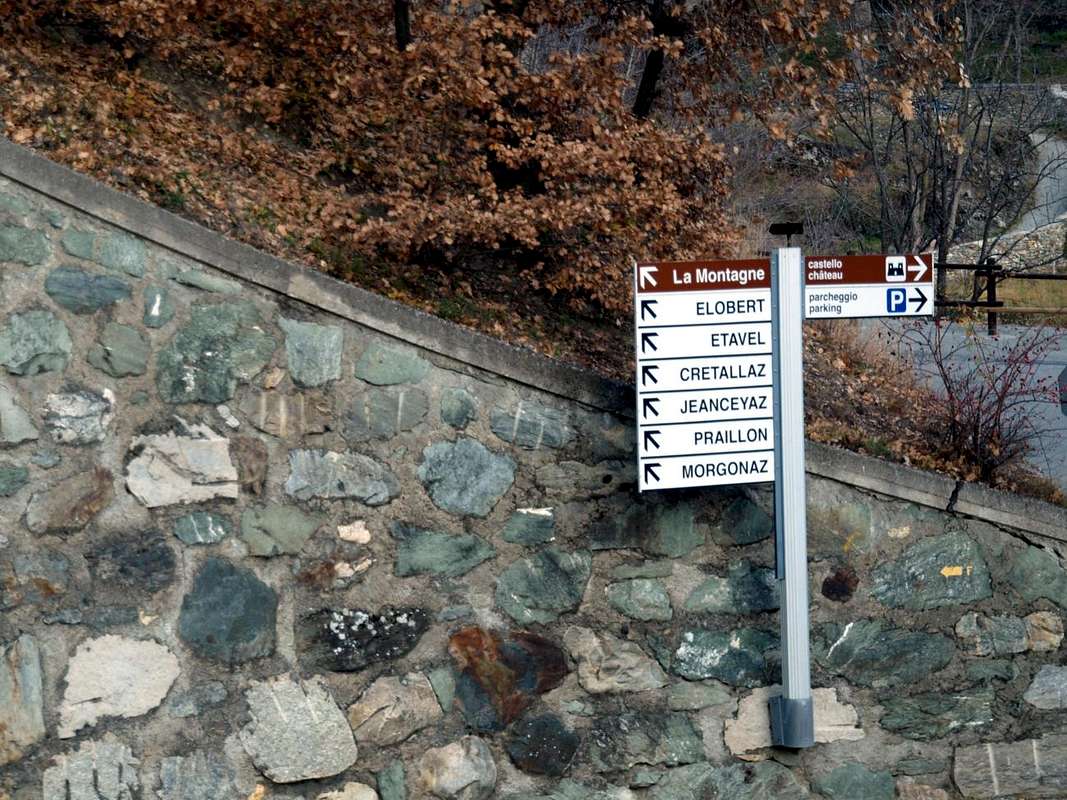
![]() Specific Road:
From Quart Municipality towards Trois Villes Hamlets
1)-
Specific Road:
From Quart Municipality towards Trois Villes Hamlets
1)- Just after the Fraction of Quart Commune (Etolin, Vieille Morte, la Plantaz-Chétoz (better), turn to the left or North-northeast, in the direction of
Trois Villes (parking).
2)- With alternative road: Aosta East toll of the highway follow on the right side towards Quart (
556m near the Region Amérique); after the roundabout follow up toward Villair. After passing Argnod
(857m), Vignil
(946m), Fornail
(1082m) and Ville sur Nus
(1106m) turn left towards
Trois Villes Avisod (1398m), wherefrom you must start walking.
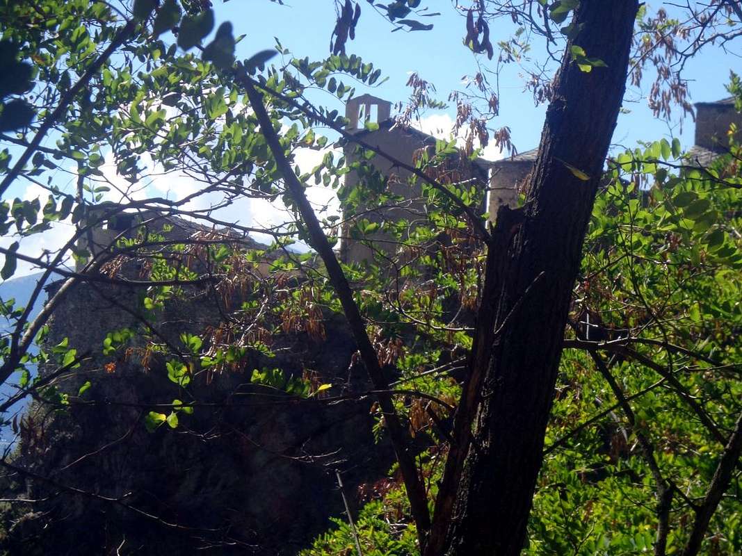
![]() Specific and alternative or direct Road:
From Villair-de-Quart towards Jeanceyaz Fraction with connection towards Morgonaz-Praillon Villages
3)-
Specific and alternative or direct Road:
From Villair-de-Quart towards Jeanceyaz Fraction with connection towards Morgonaz-Praillon Villages
3)- By the Fraction of Villair-de-Quart reach, with Regional Road, the junction neaby Villair Castle (
740m; parking); from this with large windings road to Elobert
(961m) and Etavel
(1056m) Villages. Continue Northwest reaching the fork
(1087m) near the Chapel of
Jeanceyaz (1092m) and connection with the following route
4)- by St. Christophe Common. With this continue East reaching Morgonaz
(1181m) and Praillon
(1262m) Villages at the end of road in asphalt and at the beginning of dirt road to Senevé Basin.
![]() Alternative Western Road Road:
From St. Christophe Commune towards the fork "La Montagne"
Alternative Western Road Road:
From St. Christophe Commune towards the fork "La Montagne".
4)- By St. Christophe directly towards Sorreley Fraction up to the fork
"la Montagne" (1025m), immediately above the Lumian
(984m) isolated Pasture and in East to Cretallaz
(1087m), Jeanceyaz
(1092m), Morgonaz
(1181m) and
Praillon or Prayon (1262m) small Villages at the end of road in asphalt and at the Western entrance on Senevé Basin.
Alternative Eastern Road Road:
From Nus Commune towards St. Barthélemy Valley and connection to Trois Villes-Avisod.
5)- From Aosta Town to address him to is long the State Rosd n° 26, after the Commune of Quart coming in that of Nus (reached even with the same Eastern Road by Châtillon Common). From
Nus (960m), with Regional Road before in North, towards Marsan
(699m), Tolasèche
(854m), Petit-Fénis
(939m), Blavy
(1056m), Hamlets; after through the same but in Northeast crossing Val Dessous and Dessus
(1173m, 1268) Villages below Mont de Pesse and above St. Barthélemy Torrent. Finally East-northeast towards the locality
"Les Fabriques (1411m), and Issologne
(1514m) Village under Mont Andér and Cima Longhede; hence, turning decisively West, up to
Lignan-Saint Barthélemy Hamlet (1633m) and the subsequent Clémensod Village
(1655m). From this last towards Regional connection Road in West towards Arlod
(1554m), Valservière
(1502m), Effraz
(1487m) Villages at the foot of Becca d'Aveille
(2623m) and
Trois Villes-Avisod Hamlets arriving neighboring the
"Monument to Partisans" area
(1364m).
![]() By plane:
By plane:
Aeroporto Internazionale "Corrado Gex" Saint Christophe (Aosta).
Thinking of going up this canyon completely starting from the very ancient Castle of Villair de Quart to reach the wide pastures and summit arid moraines between the Alps of Chavod (to the West) and Lattaz is madness, since the rocky bottleneck under the Alpe Séchot is unsurpassable, or almost. At least for ordinary hikers with little knowledge of the area. This is an environment only for ultra experienced hunters ... For hikers wishing to admire these ravines, only the choice remains to follow the same one keeping up on the farm that from Praillon or Prayon reaches Alpe di Borelly and then, with a wider tour always to the West, those of Chamerod
(1.614m) and Preilles or Les Preyes (
1.802m; in this last stretch the path
n ° 1 serves as a useful shortcut). From this last pasture, continuing along the same path towards the north through the forest, you can reach Alpe di Senevé or Cénevè, just above that of Chavod. On the opposite or Eastern side, a farm road, starting from Avisod Hamlet, runs from above all the Senevé Comba also Bain passing over the Valseinte's Pastures and reaching those of Vacheresse (
1.675m), Nouva (
1.830 meters about), Champ-Chamoussin, Lattaz and ending towards that more high of Senevé
(2.199m). In addition, you can make a semicircular tour around the canyon going up to Alpe di Senevé with one itinerary and descending with the other, straddling the two Municipalities of Saint Christophe and Quart and vice versa.
![]()
As far as the small paths are concerned, the lower links, between the junction
1.777 meters before Les Preilles or Les Preyes Alpages
(1.791m) and the Planes Pastures
(1.551m), are by no means advisable, because they are now semi-abandoned and traveled only by profound connoisseurs of the area or, better, by the local ninhabitants. On the other hand, the path, also unnumbered, which from the junction on the farm or dirt road before Séchot Alp
(in descent from 1.500 to 1400 meters approximately) crosses the Torrent de Château de Quart and subsequently that of Florencière in altitude of
1.528/30 meters about, beyond below the renovated Village of Chamerod
(1.614/8 meters about), Furthermore it reaches the Alpe di Rapailles
(1.541m), sited on rocky-grassy promontory, not crossing the other bank but returning towards the East to rejoin, less and less evident, at the bend
1.708 meters (before Vacheresse's Pastures ) on the farm road from Trois Villes three Villages (Avisod Hamlet). Good scenic tour of the canyon, but with the same previous considerations, because the path, fairly good up to the Torrent de Florencière, becomes much less evident by turning right (East) from an altitude of
1.228 meters and then, after having crossed in altitude of
1.600/10 meters about the Torrent de Château de Quart again, to reach, as already mentioned, again the farm road to Alpe Vacheresse
(1.765m) with an almost perfectly circular loop. Thinking of going up this canyon completely starting from the very ancient Castle of Villair de Quart to reach the wide pastures and the summit arid moraines between the Alps of Chavod (to the West) and Lattaz is madness, since the rocky bottleneck under the Alpe Séchot is unsurpassable, or almost. At least for ordinary hikers with little knowledge of the area. This is an environment only for ultra experienced hunters ...
To conclude, we recommend a complete hiking tour around the canyon passing from the superior Alpe di Senevé (water into a spring just to the Northwest)at the foot of the watershed which from Mont Mary/Tête d'Arpisson reaches Tsaat à l'Etsena/Becchi di Fana, or some partial visits suspended over the ravine, as from a blind-bottomed farm road just before and immediately to the Northeast of Alpe Praillon.
Pensare di risalire completamente questo canyon partendo dall'antico Castello del Villair de Quart per arrivare fino al sommo dei pascoli precedenti le aride morene tra le Alpi di Chavod (ad Ovest) e Lattaz é una follia, poiché la strozzatura rocciosa sotto l'Alpe Séchot risulta insuperabile, o quasi. Almeno per escursionisti comuni e poco a conoscenza del territorio. Questo é ambiente solo per cacciatori ultra esperti ...... Per gli escursionisti desiderosi di ammirare questi esposti nonché selvaggi ed impraticabili burroni rimane esclusivamente la scelta di percorere il medesimo sentiero tenendosi in alto sulla poderale che dal tornante a gomito subito dopo la presa d'acqua di Praillon o Prayon (1.290/1.300 metri circa; tralasciare la strada poderale che continua verso sinistra od Ovest-nordovest) raggiunge l'Alpe di Borelly e poi, con giro più ampio sempre ad Ovest, quelle di Chamerod e Preilles o Les Preyes (1.802 m; in questo ultimo tratto il sentiero n° 1 funge da utile scorciatoia). Da questo ultimo alpeggio, proseguendo con lo stesso sentiero verso Settentrione attraverso la foresta, si può raggiungere l'Alpe di Senevé oppure Cénevè, appena soprastante quella di Chavod. Sul lato opposto od Est una strada poderale, partendo da Avisod, percorre dall'alto tutto il Vallone di Senevé passando sopra l'Alpe di Valseinte e raggiungendo quelle di Vacheresse (1.675 m), Nouva (1.830 metri circa), Champ-Chamoussin, Lattaz nonché terminando verso la superiore di Senevé. Inoltre si può effettuare un giro semicircolare intorno al canyon salendo all'Alpe di Senevé con un itinerario e scendendo con l'altro, a cavallo dei Comuni di Saint Christophe e Quart e viceversa.
![]() Per quanto concerne i sentierucoli di collegamento più in basso (tra il bivio 1.777 metri prima di Les Preilles e l'Alpe di Planes), non sono per nulla consigliabili, perché ormai semiabbandonati e percorsi soltanto da profondi conoscitori della zona. Invece il sentiero, non numerato anche esso, che dal bivio sulla strada poderale prima di Séchot (con discesa da 1.500 a 1.400 metri circa) raggiunge in traversata il Torrent de Château de Quart e successivamente quello di Florencière a quota 1.528/30 metri circa, al di sotto del Villaggio ristrutturato di Chamerod (1.614/8 metri circa), jnoltre perviene all'Alpe di Rapailles (1.541 m) non oltrepassando sull'altra sponda bensì rientrando verso Oriente per andare a ricongiungersi, sempre meno evidente, al tornante 1.708 m (prima dell'Alpe Vacheresse) sulla strada poderale da Trois Villes (Avisod). Buon tour panoramico sul canyon, ma con le stesse precedenti considerazioni, perché il sentiero, discretamente buono fino al Torrent de Florencière, diventa alquanto meno evidente svoltando a destra (Est) da quota 1.228 metri per poi, dopo aver nuovamente guadato il Torrent de Château de Quart, raggiungere, come già detto, ancora la strada poderale all'Alpe Vacheresse con un giro quasi perfettamente circolare. Pensare di risalire completamente questo canyon partendo dall'antichissimo Castello di Villair de Quart per raggiungere gli ampi pascoli e le aride morene sommitali tra le Alpi di Chavod (a Ovest) e Lattaz è una follia, poiché la strettoia rocciosa sotto l'Alpe Séchot è insuperabile, o quasi. Almeno per gli escursionisti ordinari con poca conoscenza della zona. Questo è un ambiente solo per cacciatori ultra esperti...
Per concludere si consiglia il giro escursionistico completo intorno al canyon passando dalla soprastante Alpe di Senevé (2.199 metri) ai piedi della Costiera che dal Mont Mary/Tête d'Arpisson/Campanile e Punta di Senevé raggiunge Tsaat à l'Etsena/Becchi di Fana, oppure alcune visite parziali sospese sull'orrido, come da una stradina poderale a fondo cieco appena antecedente nonché subito a Nordest dell'Alpe Praillon.
Per quanto concerne i sentierucoli di collegamento più in basso (tra il bivio 1.777 metri prima di Les Preilles e l'Alpe di Planes), non sono per nulla consigliabili, perché ormai semiabbandonati e percorsi soltanto da profondi conoscitori della zona. Invece il sentiero, non numerato anche esso, che dal bivio sulla strada poderale prima di Séchot (con discesa da 1.500 a 1.400 metri circa) raggiunge in traversata il Torrent de Château de Quart e successivamente quello di Florencière a quota 1.528/30 metri circa, al di sotto del Villaggio ristrutturato di Chamerod (1.614/8 metri circa), jnoltre perviene all'Alpe di Rapailles (1.541 m) non oltrepassando sull'altra sponda bensì rientrando verso Oriente per andare a ricongiungersi, sempre meno evidente, al tornante 1.708 m (prima dell'Alpe Vacheresse) sulla strada poderale da Trois Villes (Avisod). Buon tour panoramico sul canyon, ma con le stesse precedenti considerazioni, perché il sentiero, discretamente buono fino al Torrent de Florencière, diventa alquanto meno evidente svoltando a destra (Est) da quota 1.228 metri per poi, dopo aver nuovamente guadato il Torrent de Château de Quart, raggiungere, come già detto, ancora la strada poderale all'Alpe Vacheresse con un giro quasi perfettamente circolare. Pensare di risalire completamente questo canyon partendo dall'antichissimo Castello di Villair de Quart per raggiungere gli ampi pascoli e le aride morene sommitali tra le Alpi di Chavod (a Ovest) e Lattaz è una follia, poiché la strettoia rocciosa sotto l'Alpe Séchot è insuperabile, o quasi. Almeno per gli escursionisti ordinari con poca conoscenza della zona. Questo è un ambiente solo per cacciatori ultra esperti...
Per concludere si consiglia il giro escursionistico completo intorno al canyon passando dalla soprastante Alpe di Senevé (2.199 metri) ai piedi della Costiera che dal Mont Mary/Tête d'Arpisson/Campanile e Punta di Senevé raggiunge Tsaat à l'Etsena/Becchi di Fana, oppure alcune visite parziali sospese sull'orrido, come da una stradina poderale a fondo cieco appena antecedente nonché subito a Nordest dell'Alpe Praillon.

 1121 Hits
 79.04% Score
 10 Votes