Croix de Fana (2212 m) a humble but popular Summit

Croix de Fana (2212 m) a humble but popular Summit

Page Type Page Type: Article
Activities Activities: Hiking

Cross OVERVIEW

This mountain we recently visited in "Mountains & Rocks", but we return to talk about the same with three simple goals: 1)- offer some "renseignements" historical-cultural-tourist anymore; 2)- customize what has been the most "experienced" in dealing with the same, and 3)- give some small advice to support the goodwill and maybe the lack of knowledge of the area to Hikers who come from out of the Aosta Valley or simply do not know. However, the same has obtained a progressive "escalation" with the increase from year to year by visitors to the mid-mountain or even as a training ride of the season, but increasingly there has been some winter hike.
This mountain shaped like a big "cake" rounded, more wooded rocky overhangs the three fractions Trois Villes (Porsan, Davisod and Fonteil) in the below Municipality of Quart (to "Quartum milium") before entering the now bi-millennial Town of Aosta ("Augusta Praetoria Salassorum" of the ancient Romans and "Cordelia" for the Prince "Cordelus" King of the Celts/Salassians). In addition, after a long stretch pseudo straight, the watershed gets up to Passo Alto (High Pass; around 2540 metres), the door of communication between the Basin Sénevé West and the Comba Dèche, before rising to homonyms Becchi (Beaks; 2951m) where the ridge becomes more important, as well as progressively rocky. After the ridge down to the Colle di Fana to reach the Summit of the Eastern Tsaat a l'Etesena (2973/4m), the highest point in the chain. This trait becomes a node topographic important so as to separate the two walloons of the Municipality of Quart, once not only suppliers of all water for the population but also the primary source of livelihood by the pastoralism; these pastures lately, and rightly so, have been completely renovated. The positioning of the Cross by locals dates back to the mid-50s, while on the plain below the three Trois Villes Villages was erected immediately after the war a great soldier or "Monument to the Partisan" (1364m) to witness the struggle between them and the Nazi-Fascist regime. A reprisal during the Second World War almost completely burned the village of Trois Villes (1390m), today completely re-established and re-inhabited by the locals with a few small tourist village that, at least in the summer, keep it alive and worthy of a visit also from the point of view of history. More rare acquaintances in the desolate walloons with Comba Sénevé to the West directed almost exclusively to livestock farmers, while on the opposite side, in addition to this activity well developed, there is a renowned and very popular in the past Saint Barthélemy Hill (2639m), ancient crossing to the North with the nearby Valpelline.


Under the Winter Fana Summit Cross


Anche questa montagna abbiam da poco tempo visitato in " Mountains & Rocks", ma ritorniamone a parlare con tre semplici obiettivi: 1)- offrire alcuni "renseignements" storico-cultural-turistici in più; 2)- personalizzare maggiormente quello che é stato il "vissuto" nel rapporto con la stessa e 3)- dare qualche piccolo consiglio a supporto della buona volontà e magari della scarsa conoscenza del territorio ad Escursionisti provenienti da fuori della Valle di Aosta o che, semplicemente, non la conoscano. Comunque la medesima ha ottenuto una progressiva "escalation" con l'aumento di anno in anno da parte di frequentatori della media montagna o pur come gita di allenamento di inizio/mezza stagione.
Questa montagna a forma di grande "panettone" arrotondato, più boschivo che roccioso, sovrasta le tre Frazioni di Trois Villes (Porsan, Davisod e Fonteil) nel sottostante Comune di Quart ("ad quartum milium") prima dell'ingresso nella ormai bi-millenaria Città d'Aosta ("Augusta Praetoria Salassorum" dei Romani e più anticamente "Cordelia" per il Principe "Cordelus" Re dei Salassi, locale popolo Celtico). Oltre, dopo un lungo tratto pseudo rettilineo, lo spartiacque si rialza al Passo Alto (2540 metri circa), porta di comunicazione tra il Bacino di Senevé ad Occidente e la Comba Dèche, per poi impennarsi agli omonimi Becchi (2951 m) dove la cresta diventa ben più importante, nonché progressivamente rocciosa. Dopo la cresta scende al Colle di Fana per raggiungere la Sommità Orientale della Tsaat a l'Etesena (2973/4 m), punto più elevato della catena. Questo tratto diventa un nodo topografico importante, tale da separare i due valloni del Comune di Quart, una volta non solo fornitori di tutte le acque per la popolazione ma anche fonte di primaria sussistenza per mezzo della pastorizia; questi alpeggi ultimamente, e giustamente, sono stati completamente ristrutturati. Il posizionamento della Croce da parte degli abitanti locali risale alla metà degli Anni Cinquanta, mentre nella piana sottostante i tre Villaggi é stato eretto nell'immediato dopo guerra un "Monumento al Partigiano" a testimonianza delle lotte con il Regime Nazi-Fascista. Una rappresaglia durante la Seconda Guerra Mondiale bruciò quasi completamente il Villaggio di Trois Villes (1390 m), oggi rifondato e nuovamente abitato da parte dei locali con qualche piccolo insediamento turistico che, almeno nella bella stagione, lo mantengono ancor vivo nonchè degno d'esser visitato, anche dal lato istorico. Più rare le frequentazioni nei valloni con la desolata Comba di Senevé ad Occidente rivolta quasi esclusivamente agli allevatori di bestiame, mentre sul lato opposto, oltre a questa attività ben sviluppata, esiste il conosciuto, nel passato ben popolare, Colle di Saint Barthélemy (2639 m), antico valico con la viciniora Valpelline.

Old Recollections & Echos

When you see People go up to the Croix de Fana means that Spring is coming. The Cross, facing South, grab the first rays of the sun in the East and deposits them in the late afternoon to the West, towards Mont Blanc and its enormous Mountain Chain, which has this great "pulpit" well you see at the horizon. Beneath the Town of Aosta already asleep and only the silver ribbon of Dora Baltea you draw among the thousands of lights that turn with the arrival of the Night. A perfect line of mountains draws a large profile in contrast with the sky, like a brown snake that stretches from East to West, from Lower to Middle Aosta Valley up to the Rutor sparkling glaciers. Even the winds here generally impetuous, silent and suddenly the viper begins to open her eggs. With each new Dawn will find that the snow flies higher and higher, giving ample space to the meadows that are starting to revive. For starters, as with all the other balconies facing the Valley to the South. When the morning of the Epiphany in 1969 climbed to Trois Villes with the Mini Minor, colored sugar paper, by Hilary the conditions, more or less, were these. The Winter was late and we wanted to take advantage of this factor to try to make the first winter ascent to Tsaat à l'Etsena; we started from here because there was still a private dirt road for Comba's Sénevé. An approach very long, reached the Croix de Fana and traveled all over the watershed to the High Pass (around 2540m; then unnamed) under the Jaws of Fana, would allow a diagonal descent to take us to the base of the large canal that goes up to the Hill of Fana, between the Beaks and Estern Tsaat. Climb to the Croix was a walk and do not even remember, busy as usual, during the approach, chatting making plans. But come on the Summit, in a cold morning with the sky streaked with icy white lines, we realized that to continue North on the ridge was impossible: every step we sank deeper and deeper into the deep snow that the last snowfall and the wind had framed on the ridge. A nasty surprise because we did not have snow shoes and only wore Ilario, tied over the backpack, a pair of skis Thirties. Two wooden planks with a huge tip pointing upward to (as seen in old photos ski Finnish) and a rusty attack Kandahar. It was all, and after a hundred metres we had to make a retreat coming back to the Cross. Other than Tsaat! The same was looking at us, mocking among a flurry of snow that enveloped her two Summit: the Man proposes and the Mountain has ... What to do? Well, while you make two pictures and then you eat this because cold air makes you an appetite! Then it's time to get off and Hilary is an idea white mark: descend directly with skis on steep South Slope in the middle of blocks, broken rocks, bushes and trees. I look down: crazy things with those two tables dry! But he who seeks a thrill daily (in those days there was no talk of withdrawal adrenaline) does not think twice and threw himself down. With great shots of hip to make the curves, while I remain apprehensive, a moment arrives at the plateau downstairs. I can only get there on foot to the ascent route passing through a petrified forest and skeleton, with the snow that is no longer the one in the morning because the sun has turned and it sinks down to his knees, and even more ... I wanted to write about this trip than forty-five years ago with only the Memory and then make a comparison with what is written in our diaries climbing at the time; it is quite funny to see how they are counterfeit memories. It seemed that in a moment we were back at the base and that the climb was devoid of snow; since my past:


From Cross Southward, facing Grande Rouèses Mountain Chain above Arpisson/Laures Walloons


" ... but soon we realize that if we arrive at Croix (which we called Croux in a wrong language, mixture of Italian, French and patois) will already be much, much higher and the snow is soft. In fact "swimming" and crawling at 11.15', with a cold wind and strong, we are at the cross. Sit behind a hump of snow which shelters us from the wind and cold, and happy with our small victory, the day of Epiphany enjoy the pale sun shining above the mountains that surrounds the mist in the valley"
. And from what Hilary: "Magnificent day of winter is. Trois Villes reach by car and from there continue on foot (I put on skis for a while). The climb is made increasingly difficult by the very high snow (in some places almost has to swim to proceed). The cold is intense, but the valleys and surrounding mountains are flooded with light and beauty repays all toil and suffering. A night descend. Past the steepest section on foot to wear the skis that I quickly lead to the valley with great fun. To enjoy the last rays of the sun, then it's back home." As you can see the Memory is actually at different points in contrast with Reality; things to psychological studies or neuro. This was the first Croix de Fana, who left us but the bitter conviction that we would never have achieved the first winter at Tsaat. Too far from approaching winters and there are even worse. Instead, the Time is honest and in the following years I realized at both the Summit and to all the others of this small chain that begins in the West with the Becca of Viou. Not with Hilary, who unfortunately in the end of September of the same year he died, but with other companions that Destiny brings you to meet. In the meantime, go to Croix had become a custom of beginning of the season to make a good workout, for which reason the slopes of this mountain became a tradition with different routes and ridges on all its sides. After can become a Mirage.


Fana watershed from Cross up to the Beaks overhanging Comba Dèche, with South-southeast view


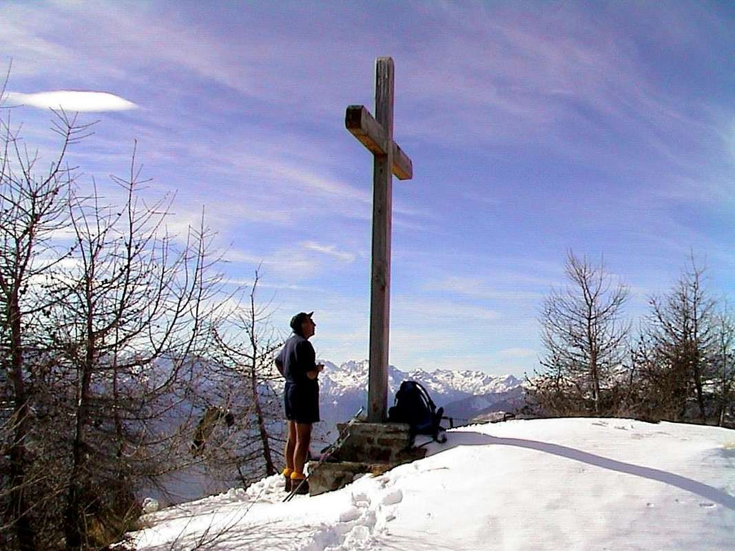
Quando Voi Gente vedete salir la Croix de Fana significa che Primaver sta per arrivar. La Croce, rivolta a Sud, afferra i primi raggi del sole ad Oriente e li deposita nel tardo pomeriggio ad Occidente, verso il Monte Bianco e la sua enorme Catena, che da questo grande "pulpito" ben si vedono all'orizzonte. Al di sotto la Città di Aosta già dorme e solo il nastro d'argento della Dora Baltea si disegna tra le mille luci che s'accendono con l'arrivo della Notte. Una linea perfetta di montagne traccia un grande profilo in contrasto col Cielo, come un'oscuro serpente che s'allunga da Est ad Ovest. Anche i venti, qui generalmente impetuosi, improvvisamente taccion e la vipera incomincia a dischiudere le sue uova. Ad ogni nuova Alba troverete che la neve sfugge sempre più in alto, dando ampi spazi ai prati che iniziano a rinverdire. Per primi, come per tutti le altre balconate della Valle rivolte al Mezzogiorno. Quando in quel mattino dell'Epifania 1969 salivamo verso Trois Villes con la Mini Minor, colore carta da zucchero, di Ilario le condizioni, più o meno, erano queste. L'Inverno era in ritardo e noi volevamo approfittarne per cercare d'effettuare la prima salita invernale alla Tsaat à l'Etsena; partivamo da qui non esistendo ancora la strada poderale per la Comba di Senevé. Un approccio molto lungo che, raggiunta la Croix de Fana e percorso tutto lo spartiacque insino al Passo Alto (circa 2540 m; allora senza nome) sotto i Becchi di Fana, avrebbe permesso con una discesa in diagonale di portarci alla base del gran canale che risale al Colle di Fana, tra i Becchi e la Punta Est di Tsaat. Salire alla Croix fu una passeggiata e non la ricordo nemmeno, intenti com'al solito, durante gli avvicinamenti, a chiacchierare facendo progetti. Ma giunti sulla Sommità, in un mattino freddo con il cielo striato da gelide linee bianche, ci accorgemmo che proseguire a Nord sulla cresta era cosa impossibile: ad ogni passo si affondava sempre di più nella neve alta che le ultime nevicate ed il vento avevano incorniciato sul crinale. Una brutta sorpresa perché non avevamo racchette da neve ed il solo Ilario portava, legati sopra lo zaino, un paio di sci Anni Trenta. Due tavole di legno con una enorme punta rivolta allo in sù (come si vede nelle vecchie foto per gli sci finnici) ed un arrugginito attacco Kandahar. Era tutto e dopo un centinaio di metri dovemmo batter in ritirata tornando indietro alla Croce. Altro che Tsaat! La stessa ci guardava beffarda tra un turbinio di neve avvolgente le sue due Sommità: l'Uomo propone e la Montagna dispone ... Che fare? Beh, intanto si fanno due foto e poi si mangia perché st'aria fredda fa venire un certo languorino! Poi vien l'ora d'andar giù ed ad Ila viene in mente un'idea balzana: scendere direttamente con gli sci sul ripido Versante Sud in mezzo a blocchi, rocce rotte, cespugli ed alberi. Guardo abbasso: cose da matti con quelle due tavole secche! Ma lui che cerca una emozione giornaliera (a quei tempi non si parlava ancora di astinenza da adrenalina) non ci pensa due volte e si butta giù. Con grandi colpi d'anca a far curve, mentr'io rimango apprensivo, in un attimo arriva al plateau dabbasso. Non resta che raggiungerlo per la via di salita passando attraverso una scheletrica e pietrificata foresta, con le neve che non é più quella del mattino perché il sole l'ha trasformata e si affonda fino alle ginocchia ed anche di più ... Ho voluto scrivere di questa gita di quarantacinque anni orsono solo con la Memoria per poi farne il confronto con quanto scritto nei nostri Diari Alpinistici; é abbastanza divertente vedere come vengano contraffatti i ricordi. Pareva che in un attimo fossimo rientrati alla base e che la salita era priva di neve; vediamo dal mio d'allora:


"A petrified forest with skeletal trees accompanied the descent towards Trois Villes"


" ... ben presto però ci accorgiamo che se ci sarà dato di arrivare alla Croix (che allora chiamavamo Croux in un idioma erroneo, misto tra italiano, francese e patois) sarà già tanto, tanto la neve é alta e molle. Infatti "nuotando" e strisciando alle 11,15', con un vento freddo e forte, siamo presso la croce. Ci sediamo dietro ad una gobba di neve che ci ripara dal vento e dal freddo e, contenti della nostra piccola vittoria, nel giorno dell'Epifania godiamo del pallido sole che avvolge i monti lucenti sopra la foschia della valle."
E da quello di Ilario: "E' una magnifica giornata d'inverno. In auto raggiungiamo Trois Villes e di qui proseguiamo a piedi (io calzo gli sci per un tratto). La salita é resa man mano più difficile dalla neve altissima (in certi punti si deve quasi nuotare per procedere). Il freddo é intenso, ma le valli ed i monti circostanti sono inondati di luce e la loro bellezza ci ripaga da ogni fatica e sofferenza. A sera scendiamo. Superato il tratto più ripido a piedi calzo gli sci che mi portano velocemente a valle con gran divertimento. Gustiamo gli ultimi raggi di sole, poi si fa ritorno a casa." Come si può notare la Memoria risulta in diversi punti effettivamente in contrasto con la Realtà; cose da studi psicologici o da neuro. Questa é stata la prima Croix de Fana, che ci lasciò però la amara convinzione che non avremmo mai realizzato la prima invernale alla Tsaat. Troppo lontana da avvicinare e di inverni ce ne sono anche di peggiori. Invece il Tempo é galantuomo e negli anni successivi la realizzai a tutte e due le Sommità, nonché a tutte le altre di questa piccola catena che inizia ad Ovest con la Becca di Viou. Non con Ilario, che purtroppo nel fine di Settembre dello stesso anno morì, ma con altri compagni che il Destino ti porta ad incontrare. Nel frattempo andare alla Croix era diventata una usanza di inizio stagione per compiere un buon allenamento, per la qual cosa le salite a questa montagna diventarono una tradizione con itinerari diversi su tutte le creste ed i suoi versanti. Poi nel tempo, inclemente per tutti, anche l'ascesa alla Croix può divenir Miraggio.


Beaks of Fana and Tsaat à l'Etsena Tops above Passo Alto & Croix de Fana, with Southeastern view

Some Ideas, Advices & Suggestions


Winter Rest on New Senevé or Cénevé Alpage (2200m)


Some information or simple tip we can give you about it this easy hike but sometimes has some unknown: a)- do not be attracted by the direct ascent on the North Slope, as well as boring and tiring; b)- instead use the handy marked trail that starts at the small parking lot Fonteil, climb diagonally toward the Northwest and then, turning gradually to the north, reaching the "Crestone" Southeast and is crossed by an ancient forest "petrified" quietly leads Westward to the plateau below the Summit. If you want to continue through the Dèche Comba, further East, follow the path next, always reported, which with a first initial steep ramp detaches itself from the private road; c)- but if there is still snow should follow this with a longer ride to the inside of the Comba to Flemagne Pasture (1709m) and this fall in the opposite direction towards the "ridge". Otherwise d)- in the case of deep snow use this path, quite safe from snowslides by means of snowshoes; last hypothesis e)- if the snow is too high should discard this route and follow the previous year. If you want to climb through the Senevé Basin f)- go to the alp of the same name by the farm road and then not numbered with small path, which starts from the Higher Alp Champchamossin (1851m), through the forest towards Southeast on Western Slope; in this case, here coming downhill on the contrary, absolutely avoid crossing the forest to the South and East (above the Valseinte) then to reach the "terrace", where perhaps you left the car. The path between bushes, brambles and unstable blocks is dangerous due to the presence of the viper, as well as boring and tiring (personal and unique experience). Finally, if you want to reach the Summit from the North, g)- continue on the private farm road to the junction at the Alpe Lattaz (1935m) or the next Senevé; from these a good path numbered, but difficult to identify in the first part, up to the Col Cornet (2280m) and with this easy crossing to the South you reach easily the Cross, after a short descent. This path must not have snow, or at least it should be very low and scarce level. This hill can be reached h)- also by Comba Dèche: Flemagne to continue along the farm road up to the Pastures of Brunier (1771m) and Clavel (1994m); from this reach the junction around 2020/30 metres just before the La Seyvaz Alpage 
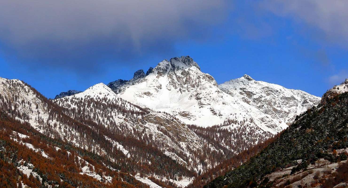
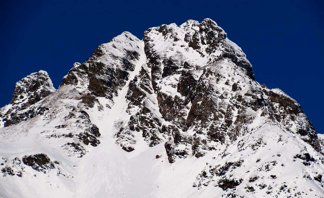
(2184m), from where a path to the South-southwest unnumbered rising through the foothills of the Eastern Becchi of Fana; crossed the great Eastern Ridge of these and crossed a creek secondary, the same, which becomes a small track, reaches the collar. This diagonal via food must be covered in the beginning of the season, because it is very exposed to avalanches from Beaks of Fana, Punta Maria Joseph Henry and Becca Conge (see photo).


From Fana Beaks up to the Becca Conge above Comba Dèche, from East-northeast


Qualche ragguaglio o semplice suggerimento possiamo darVi al riguardo di questa facile escursione che però a volte presenta qualche incognita: a)- non lasciatevi attrarre dalla salita diretta sul Versante Sud, perché noiosa e pure faticosa; b)- usate invece il comodo sentiero segnalato che, partendo presso il piccolo parcheggio di Fonteil, sale in diagonale verso Nordovest per poi, piegando progressivamente a Settentrione, raggiungere il "Crestone" Sudest ed, attraversata un'antica foresta "pietrificata", tranquillamente conduce verso Ovest al plateau sotto la Sommità. Se volete continuare tramite la Comba Dèche, più ad Est, seguite il sentiero successivo, sempre segnalato, che con un prima ripida rampa iniziale si distacca dalla strada poderale; c)- se però vi é ancora neve conviene seguire questa con un giro più lungo all'interno della Comba fino all'Alpe Flemagne (1709 m) e da questa rientrare in senso opposto verso il "crestone". Altrimenti d)- in caso di neve alta utilizzare questo percorso, abbastanza al riparo dalle slavine, per mezzo delle racchette da neve; ultima ipotesi e)- qualora il manto della stessa risulti troppo alto conviene scartare quest'itinerario e seguirne il precedente. Se si vuole salire tramite la Comba di Senevé f)- proseguire verso l'omonima alpe tramite la strada poderale e poi con piccolo sentiero non numerato, che parte dall'Alpe Champchamossin Superiore (1851 m), attraversare verso Sudest il boschivo Versante Occidentale; in questo caso, qui arrivando al contrario in discesa, assolutamente evitare di attraversare la foresta verso Sud e poi Est (al di sopra della Valseinte) per raggiungere il "terrazzo", dove magari avete lasciato il mezzo. Il percorso tra cespugli, rovi e blocchi instabili é pericoloso per la presenza della vipera, oltre a che noioso e faticoso (personale ed unica esperienza). Infine se volete raggiungere la Sommità arrivando da Nord, g)- continuare sulla strada poderale fino al bivio presso l'Alpe Lattaz (1935 m) o la successiva di Senevé; da queste un buon sentiero numerato, ma difficile da individuarsi nella parte iniziale, sale al Col Cornet (2280 m) e da questo con facile traversata verso Sud si raggiunge agevolmente la Croce, dopo una breve discesa. Questo percorso non deve presentare neve, od almeno la medesima deve risultare molto scarsa e di bassa entità. Questo colle può essere raggiunto h)- anche dalla Comba Dèche: da Flemagne continuare lungo la strada poderale fino agli Alpeggi di Brunier (1771m) e Clavel (1994 m); da questo raggiungere il bivio 2020/30 metri circa poco prima dell'Alpe La Seyvaz (2184 m), dove parte verso Sud-sudovest un sentiero non numerato che sale attraverso le pendici Orientali dei Becchi di Fana; oltrepassato il grande crestone Est di questi ed attraversato un torrente secondario, il medesimo, che diventa una piccola traccia, raggiunge il colletto. Questa via diagonale non deve essere assolutamente percorsa in inizio di stagione, perché molto esposta a valanghe (vedi foto).


Comments

No comments posted yet.