


 or
or 


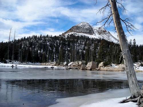 The differences are too obvious though. The lone fir tree on Island Lake is
  Just as I kept claiming that the key "KSL images #19 and #20" couldn't have been taken at Hidden Lake,


 KSL - no number but according to the uploading order it may have been taken between Hidden Lake and the "Little Meadow".
 The SAR shot
Dmitry Pruss - Aug 13, 2012 3:55 pm - Hasn't voted
Re: What makes one stop?UtahHike, I think it was said in response to even more frequent comments that "a GPS would have made all the difference". If an injury keeps one from moving, a GPS wouldn't help. If inclement weather makes one seek a shelter, a GPS wouldn't make things different. If batteries die or if you drop it and crack the screen, then a GPS wouldn't be of any use either. And of course one can even be lead astray by the GPS arrow, if the correct route circles around, bypassing difficult terrain. I'm a GPS afficionado but I've seen my share of stories of "bad choices assisted by a GPS". The point, a GPS is a great tool but not a fail-safe substitute to good planning, appropriate gear, and outdoors experience.
brly - Sep 28, 2012 11:56 am - Hasn't voted
Re: What makes one stop?Thank you Dmitry.
I should have been more specific about my comment that a GPS would not have helped. The news reports said that people should always take a GPS when they hike in areas like that. I was stating that it would not have helped them in this situation because they died from hypothermia, not from being lost. Whether they were disoriented or not doesn't change the fact that they did not survive the elements.
UtahHike - Aug 3, 2012 9:38 pm - Hasn't voted
GPS coordinates of final SAR pictureYou said the sar guy didn't tell you where it was at? By any chance, do you know if they have reports of locations somewhere which happen to be in public records?
UtahHike - Sep 20, 2012 1:42 am - Hasn't voted
Posting videos on Summitpost?Interesting website discussion. I just hiked to Hidden Lake two days ago, on Monday the 17th.
I wonder if this may supplement filwould's photo of western Hidden Lake, for those who haven't been there yet, a view without the snow. http://www.summitpost.org/western-hidden-lake-uintas/815122 One more tree has been taken out since filwould's picture (probably part of that bench of logs next to a firepit behind where you take this picture), and the water level looks a little lower this year, but I like it how the colors of the ground show.
Also, I'm new here but wonder if there's a way to post videos on Summitpost? I took a video of this part of the lake and while moving forward, as a way to show more of it to make it even more obvious to those who haven't visited.
UtahHike - Sep 20, 2012 2:58 am - Hasn't voted
Possibility of getting lostI know that some here are skeptical these two hikers could have gotten lost, however, it's always easy in hindsight to say you can't get lost when you're by a computer screen looking at a map. As far as the possibility, Search and Rescue says they often find people who claim they got turned around, especially in the Uintas. As far a personal experience, I have a GPS that marks a "track" of where I go. Often hiking with others, when returning to the trailhead I get people who insist we need to turn a different way because they swear it's the way we came. Then I'll tell them my GPS tracks us and we came from the opposite direction they think we need to return. Then as we go further the correct way that they had been skeptical about, they'll say "Oh, it looks familiar now." I've also heard quite a few people say they've climbed the wrong mountain peak, etc, etc. You often hear about studies of how hikers who don't recognize landmarks often hike in circles, to the left or right. The SAR people even mistook that picture of western Hidden Lake with Long Lake, so that's why I'm still still curious about the possibility of these two getting lost by mixing things up.
In addition to that, when I hiked there this Monday, when cutting from the Three Divide Lakes over to Hidden Lake, I got the impression people usually don't go over there unless they have a GPS, are good with a map and compass, or got turned around and went that direction. I didn't see how the average Joe off the streets hiker would just wander over there out of curiosity. I say this because you can't see Hidden Lake until you're basically already there, and along the way you cut across some rock gulley's/cliffs and have to find openings. Maybe I got that feeling only because I was hiking all by myself and knew what the weather reports said the temperature would be for the night, but I still got that impression continuing further and further down toward Hidden Lake.
I don't know, do you think perhaps it's always possible they wanted to do the Wall-Clyde Lake Loop, ventured off the usual path to explore west of Clyde Lake a little? Then when they saw the storm coming in they felt rushed to get back to their vehicle, not taking much time and effort in figuring out their navigation, making a wrong turn somewhere? When the sky started getting hazier and the Sun was less noticeable to tell south, feeling rushed to beat the storm they mistook the shape of Long Mountain for the Bald Mountain/Reid's Peak combo, went west rather than east, then when they ran into the stream connecting Hidden Lake with the Middle Fork Weber they mistakenly thought it was one of those streams which would take them to one of those popular lakes near their vehicle, all the maps show streams running down to Trial Lake, etc? (Not knowing they were being taken in the wrong direction) To me, on my Monday hike, Mount Watson looked quite a bit different than the western Notch, rocky and without the trees, but I wonder if they were tired or cold so they may not have processed as well the terrain they weren't as familiar with? Was it the National Forest Maps they had? If so, I believe those maps don't show where the trees are, like the USGS do. So I wonder if maybe they didn't figure it all out, in addition to possibly not paying much attention to the Sun as a landmark from the weather coming in paired with feeling rushed?
brly - Oct 8, 2012 9:05 pm - Hasn't voted
Re: Possibility of getting lostUmmm. They did not have a GPS!
Let's concentrate on the facts, since that is the actual point of this thread.
UtahHike - Oct 9, 2012 4:40 pm - Hasn't voted
Re: Possibility of getting lostbrly, How is brainstorming ideas of what may have happened to these two ladies getting off topic? I thought that was part of the point of this thread, discussing the possibilities of them getting lost versus actually knowing where they were traveling and one getting injured?
To clarify what I said for the post for which you're responding to above, I was exploring the notion that it may not be too much of a stretch to think the hikers got turned around. I was trying to point out that when I hiked from Clyde Lake to Hidden Lake last month, I got a pretty good impression most hikers out there will not just cross on over like that unless they are either: 1. Good with a map & compass (the news said they only had a map but no compass); 2. Have a GPS (they didn't have that); or 3. Turned around and wandering in that direction (may be a possibility for what happened with those hikers).
Since in person I got the impression your average hiker isn't going to just head on over there plus the news seems to indicate they didn't have a compass, I was evaluating the possibility they got turned around (if they were so much in a rush to beat the storm in the distance they didn't take as much time for navigating, mistaking the outline of Long Peak for Reid's Peak/Bald Mountain). I was also thinking about the possibility that since the Forest Service maps don't show the trees on mountains like the USGS do, if these two hikers were feeling rushed, terrain navigation with just a map may have thrown them off when looking at western Notch Mountain.
Dmitry Pruss - Oct 26, 2012 5:05 pm - Hasn't voted
Re: Possibility of getting lostJust noticed the continuing discussion ... I don't think you can post a video, but it's possible to embed a youtube flick in a page here.
I think there is a general agreement that these ladies didn't get to Hidden Lake on purpose. Since they were coming from Notch Mtn Pass by Clyde Lake, and since their car was at Crystal Lake TH, it's reasonable to think that they planned to complete the loop, following the trail further South to Watson and Cliff Lakes.
The locations of the final pictures tell us that they hiked West instead. There are reasonable anglers' trails between Clyde and 3 Divide lakes but they grow faint beyond, before one can see Hidden Lake. That's correct.
But a lost hiker doesn't need to know about Hidden Lake to get there. The usual sage advice is, if lost then continue on downhill. So it's like, you are going in a wrong direction, but a first there is a trail to follow, and then as the trail fades, you keep going downhill, to Hidden lake and then to its outlet stream.
It's true that sometimes people are confused about the direction of a trail, even when the things are obvious in hindsight. The worst example I recall happened on a wilderness ski backpack, on a half-day side-trip from a camp to an alipne cirque. We skied upstream along a major creek until the terrain opened up, snapped some pictures, and descended back to camp. Except one guy stopped to tinker with his bindings, and promised to catch up. Well the Sun was going down and he didn't return yet ... rescue time ... following our track upstream again, passing the spot where he saw him last ... nothing. A couple miles later we spotted him in twilight, going up the valley towards the tree line. He said he didn't pay attention and couldn't figure out if the camp was down below or up above (!) What's an unbelievable blunder to one person, is just a regular level of confusion to another, I guess...
flmomhikes - Aug 15, 2015 1:39 am - Hasn't voted
The poor lost hikers of 93We recently visited the Uintas and did the same hike as these ladies. In preparation for my trip and loading maps and looking at various information I came across this story and have been intrigued ever since. I know that it is old and has been discussed ad nauseum but I wanted to add my 3cents from Florida in now. My husband and I are relatively the same age as Carole Wetherton. We actually ended up hiking the exact same Hike(s) these ladies did (not on purpose because of crowds up at Ruth Lake). We also hike 2 and 3 days post arrival in Utah. Our hike to Long Lake was more strenuous than we thought it was going to be which we chalked up to "sea leg lungs". The next day we decided to hike to Wall Lake and up to the split just below the Notch and decide where we wanted to go. The change in elevation 430 feet, again kicked my butt, especially the last half mile reaching the top. We had planned to hike to Ibantik but because this would involve a climb back up decided to head over to Clyde even though there is no trail. I had studied our map (a Forest Sevice map) and plugged the hike into my GPS (Im a new user) so felt confident that we could do this. I knew to go past the Twin Lakes but upon reaching the 2nd Twin Lake there was no trail. I was really really surprised because I had told my husband from the cutoff to Clyde was only a half a mile and their elevations were the same so it would just be a quick jaunt over. (First forewarning have a map with terrain loaded into your GPS and use a different map that only shows topography). Following the GPS coordinates took us to a beautiful vista that overlooked Washington Lake and beyond but still was not the correct "trail" so I knew if I followed the Twin Lakes drainage we would probably find Clyde Lake, which we did, but we did have to hike up and out of the Twin Lake basin to get there. We spent most of the day at Clyde on the Western shore. We had decided from there we would complete the lop with Watson- Linear-Petit-Cliff which we did although were once again very very surprised. Having left Clyde we hiked on a well marked trail out of the basin onto Watson but on approaching Watson I don't know if we got off trail or this was the trail but we had to do some "butt slides" down to the steep area that bordered Watson. This trail was marked but still was not "the trail" that my GPS had marked. We hiked from one lake to the next fishing intermittently. When we got to Clyde I decided to hike back to the car. Around the bottom drainage of Ciff I saw two trails divide. I went up the upper one because this was shown on my GPS. It was well-marked to a point but then about a qtr mile in there was no trail. I was puzzled because although I was still a little west of the "trail" on the GPS this area seemed desolate. There also seemed like there were a lot of downed trees are really no where to go. Knowing Cliff Lake is a very popular trail, I backtracked back to the split and at that time saw a group coming from the other direction. I asked if they had come from the TH and they said yes. I told them my GPS was showing a trail off to the West and the guy told me "That was the old trail they had to make a new one bc of an avalanche". So that solved that mystery and off to home (a longer hike than shown ) I went. (OH and I hollered across the Lake at my husband so he knew the way out as well).
That being said the point of me writing is because one factor none of you have brought into account is the fatigue factor of having "below sea level lungs". THIS IS HUGE! We run 10Ks at home no problem but the 300 and 400 foot elevation changes on Days 2 and 3 of our trip (Just like the missing hikers) kicked our butts bad. We were sooooo tired the day we did the Loop especially). We got rained on the day of the Long Lake hike and were freezing and did have rain gear and a poncho. I had told my husband the day of the Loop that had it rained I would have been just really defeated (although I NEVER would have stopped). I truly believe they got cold and were disoriented to have gone to Hidden Lake. I do not know where the trail splits to go to that area but it looks like from the photos they were still enjoying their day at Clyde. I think once they got to Hidden they realized from their map they were badly lost and just decided to stop for the night, laid down and died.
I can also tell you using their same map that the Terrain is VITAL to know when hiking the Uintas. Being from Florida you really just forget about the fact that like I got confused the fork at the Notch trail is 10460 and at Clyde is 10460 but there are two elevation changes in between that involve cross drops and steep areas. My lesson is learned and I know now I need to update some maps in my GPS and also really watch the elevation changes in terms of terrain. My respect goes out to these beautiful mountains; my heart goes out to these families.
ashergrey - Nov 29, 2015 7:56 pm - Hasn't voted
The shelter revealedThe location of the final shelter is now known: http://backcountrypost.com/threads/the-mystery-of-kim-and-carole.5260/
Dmitry Pruss - Jan 4, 2017 10:15 am - Hasn't voted
Re: The shelter revealedThe location reveal something really important about the couple's knowledge. It now appears that they have become aware of their navigational mistake, and actively trying to resolve it!
Comments
Post a Comment