All valleys have a Church, a Castle or Tower and even both or a Mountain with hallmarks. Characteristic for each that applies even to entire Aosta Valley.For every trip in each of them presents this trio almost unbreakable, because it represents the history, culture and civil-religious (the latter widely spread over the entire territory of the Aosta Valley) traditions in the Centuries and Millennia to the firsts, and meeting to the Eternity for the latest. When we think of a valley, immediately it comes to mind its highest mountain, or more beautiful that inevitably stands as a symbol of that. So for the Mont Blanc or the Grandes Jorasses in the two Courmayeur Vény and Ferret Valleys, Mont Velan and Grand Combins into the Great St. Bernard adjacent Valley, Matterhorn in Valtournanche, Lyskamm in Ayas, Monte Rosa at the Lys Valley or Gressoney, Grand Paradis in Cogne and Valsavarenche, Grande Rousse to Val de Rhêmes, Sassière to Valgrisa and Rutor in La Thuile. But even those
"minor" flaunt their favorite mountain as the Mont Fallère
Pointes de Metz and Chaligne, the Grande Rochère, Becca de Luseney, Becca de Viou, Faroma, Aver, Monte Zerbion, Torché, Mont Glacier or Rosa dei Banchi, Punta Tersiva or Emilius in their valleys. A combination that becomes even more distinctive if we add a Church, a Tower or a Castle that represent in terms Religious or what heraldic, chanting the History and the Life of the Population. One aspect that the Mountaineers,
"hasty" to reach the goal and yet ignore the Hikers preferring to leave out the majesty of the views or the exclusive admiration for Nature. Fall in this way into oblivion if not in total anything despite the remaining observations that these may be the key to understand the uses and customs of a place, always a bit different from each other. A total disregard for all that has kept alive a mountain, a valley or just a country. An oversight almost incomprehensible as unforgivable, that we think to regain at least part of reviving the life of mountains, always inscrutably still in place, with that of the local
People who live at the base of the same, being born here, living and ending their journey ...
![]()
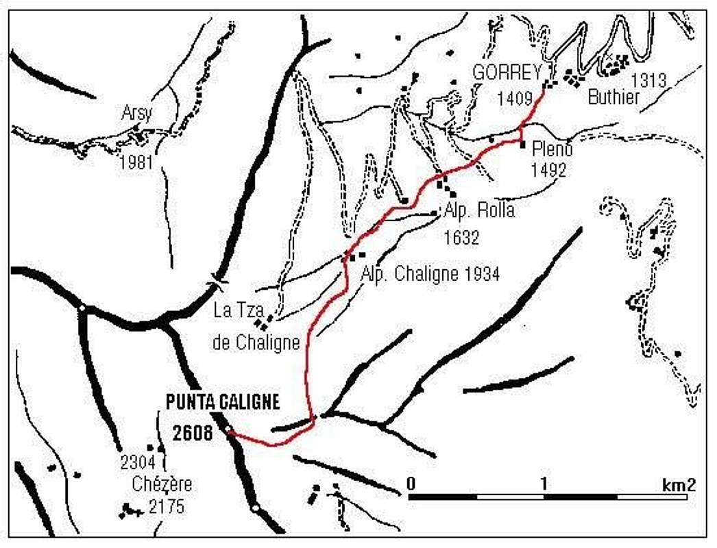
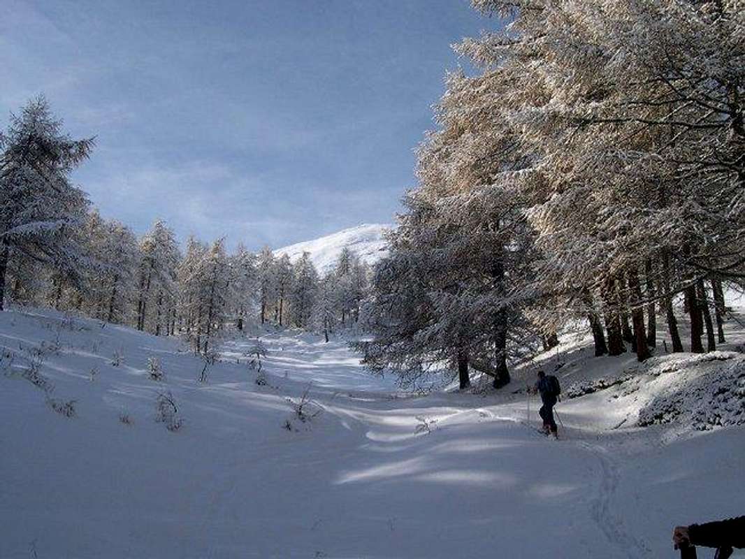
Pointe de Metz & Met Hill above the Comba de Labe and Bois Noir,
by Osw 2015
Tutte le valli hanno una Chiesa, un Castello, Torre od entrambe ed una Montagna che le contraddistiguono. Caratteristica per ciascuna valente pur per la Valle.
Infatti ogni viaggio effettuato in ognuna d'esse presenta questo trinomio quasi indissolubile, poiché rappresenta la storia, la cultura e la tradizioni religiosa (quest'ultima largamente diffusa sullo intero territorio della Valle di Aosta) e civile nei Secoli e nei Millenni per le prime, nonché l'incontro con l'Eternità per l'ultime. Quando pensiamo ad una valle, subito ci viene in mente la sua montagna più elevata o più bella che inevitabilmente si erge a simbolo della medesima. Così per il Monte Bianco o le Jorasses a Courmayeur, Mont Velan e Grand Combins al Gran San Bernardo, Cervino in Valtournanche, Lyskamm ad Ayas, Monte Rosa nella Valle del Lys o di Gressoney, Gran Paradiso a Cogne e Valsavarenche, Grande Rousse in Val di Rhêmes, Sassière a Valgrisa e Rutor a La Thuile. Ma anche quelle
"minori" ostentano la loro montagna preferita come il Mont Fallère
Punte di Metz e Chaligne, la Grande Rochère, Becca di Luseney e Becca di Viou, Monte Faroma, Becca d'Aver, Monte Zerbion, Becca Torché, Mont Glacier o Rosa dei Banchi, Punta Tersiva o Monte Emilius nelle rispettive vallate. Connubio che diventa ancor più caratterizzante se acciò aggiungiamo una Chiesa, una Torre o un Castello che le rappresentino sotto il profilo Religioso oppure quello araldico, scandendo la Storia e la Vita di quella Popolazione. Un aspetto che gli Alpinisti,
"frettolosi" di raggiungere la meta ignorano e che pure gli Escursionisti tralasciano preferendo la maestosità dei panorami o l'esclusiva ammirazione per la Natura. Cadon così nel dimenticatoio se non nell'oblio più totale le restanti osservazioni nonostante che queste possano costituire la chiave di volta per comprendere usi e costumi d'una località, sempre un pò diversi l'un dall'altro. Una totale disattenzione per tutto ciò che ha tenuto in vita una montagna, una valle o semplicemente un piccolo paese o villaggio alpino. Una dimenticanza quasi incomprensibile quanto imperdonabile, che pensiamo di recuperare almeno in parte riallacciando la vita delle montagne, sempre imperscrutabilmente ferme e piazzate al lor posto, con quella delle
Genti che vivono alla base delle medesime, qui nascendo, vivendo e concludendo il loro cammino ...
![]()
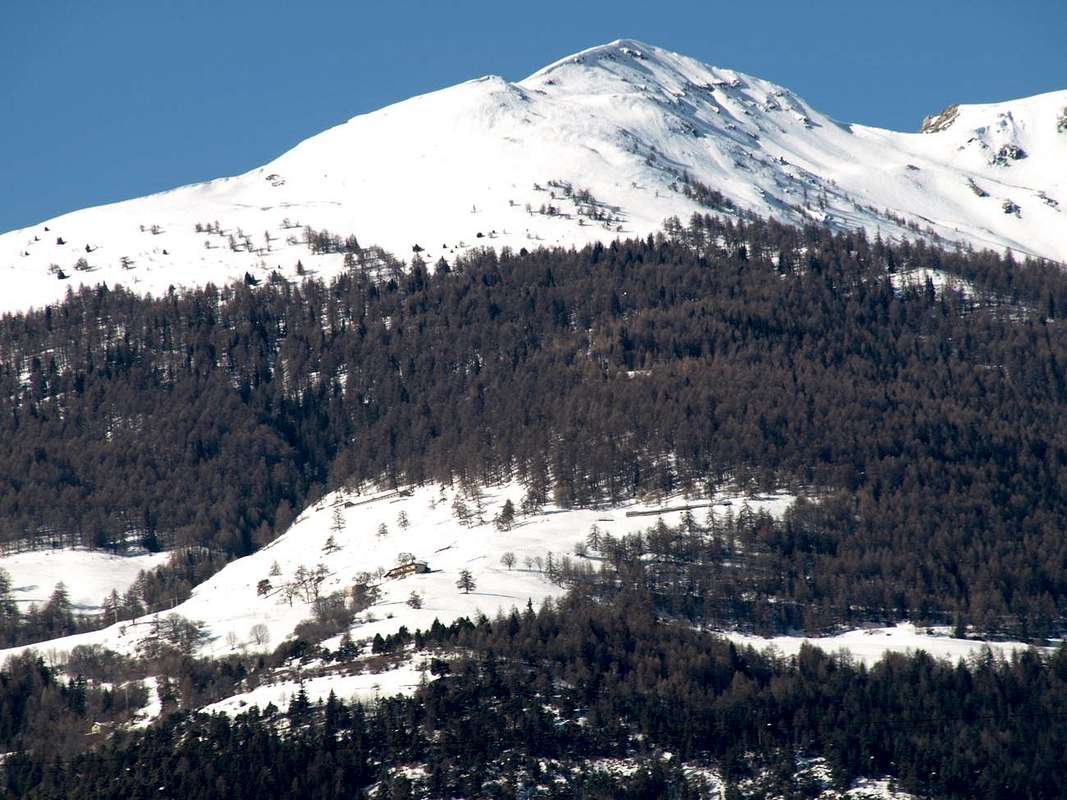
Pointe Chaligne over the homonym Vallon with Alp & Shelter,
by Maria Grazia Schiapparelli
After visiting the hill above Avise, St. Nicolas, St. Pierre e Sarre Communes
, we move further East towards always that of Sarre, Aosta and Gignod just at the entrance on the long and large Great Saint Bernard Valley. Topographically this large area semi circularly convex is divided into two distinct parts that mark the transition from the Central Valley of Dora Baltea to that of the Great St. Bernard Pass on the way to the Municipalities of Roisan and Valpelline (Northeast) and Gignod and Etroubles (North-northwest):
A)- the zone by the end of the Valley Closellaz, above Sarre, reaches the watershed from Point Chaligne
(2608m) down to the East over Variney Fraction
(782m), forming the boundary between natural and cartographic Municipalities of Aosta Gignod. A large area covered with large forests that with four distinct rocky couloirs reaches the valley floor:
1)- a first channel, maimed and facing South, which from La Cote
(1720m), immediately to the East of Thouraz, falls on Ville sur Sarre
(1212m) through the self-titled
"Ru".
2)- A second, similar and parallel to the East, that from the Condemine de Met Pastures
(1876m) falls above the Oveillan Hamlet
(853m), located West of the minuscule
"Comba Pernis" and nearby the Rochers Noirs, where is located the old rocky gym of the
"Black Rocks", so dear to the Climbers of Aosta until near the end of the Sixties.
3)- This rock band serves as the key opening the door to another area that gradually moves more towards the direction of the Southeast towards the Northern part of the City of Aosta. The Torrent de Conclonaz that originates on the slopes of the Pointe de Metz
(2553m), down, split up in two different and adjacent small vallons, and in this direction, exceeded the Villages Chavalançon
(1426m) and Conclonaz
(1236m), he concludes its run near Pont d'Avisod
(858m), precisely on the border between Sarre Aosta Commons.
4)- One last and largest rocky couloir, almost as a canyon, descends directly from under the Hill of Metz
(2492m), large grassy saddle located between Metz and Chaligne Tips, and just below the Tsa de Met or Arps Vieilles
(2251m) along the
"Comba de Labe" first toward Southeast and then falling back strongly in the South near the Village of Lin Noir
(1305m). Following the course of the Torrent of Clou Neuf through the Bois de Ban becoming a real grim rocky gorge to meet the Torrent de Conclonaz at Pont d'Avisod.
Note: this detailed territory description of this first sector may seem as futile as boring; instead it is of fundamental importance in Hiking, because a series of paths, sometimes reported and some not, reaches the mid-hill, certainly frequented
"ab immemorabilis" and today fallen, due to the construction of numerous roads, a little into oblivion
B)- This second sector, aimed at greater Northeast towards Valpelline and North-northwest to the Great St. Bernard Valley and above the Municipality of Gignod (
994m; 6.6 Km. from Aosta), despite having roughly the same territorial dimension of previous shows a morphology somewhat more simplified that can be divided into two parts precise:
5)- From the watershed to Arpuilles and Excenex Fractions
(1040m, 1046m), all villages still under the Municipality of Aosta, and up Variney under the Municipality of Aosta, to reach those Vefan, Planet-Fiou and Tercinod
(1084m, 1078m, 1083m), now belonging to the Gignod Municipality over which falls a great forest covered by a single important path from Tercinod Hamlet. This area, rather much populated in part low and purely by forest in the medium-high, is separated from the next by a large gully that fit winding descends to the valley floor. The same is crossed by the Torrent Val Buthier that originates with various small ramifications underlying Punta Chaligne and Col Tardiva; is reassembled at the two Alps Arolla
(1794m, 1698m) and then down on to that of Fontanin and, past the Village of Grand Buthier
(1302m) and the National Road No. 27 up the junction
1074 metres (towards Allein), conclude in Torrent Artanavaz or Buthier de Bosse, who hails from Comba du Merdeux now fully in the Gran San Bernardo Valley.
6)- A well more open area, marked by large pastures and with its many alpages, which is contained in the West by a large forest below the Pass and the Coast or Crest Tardiva
(2410m, 2418m, 2333m), attached with the next Vallone of Arsy or Ars, now completely over the Municipality of Etroubles. The same forest is crossed by a private dirt road that starts from the junction at
1834 metres nearby Arolla Damon Pasture (reachable from Condemine on Highway No. 27 and through the Villages of Petit and Grand Buthier;
1439, 1302 metres), first reach the new Chaligne Refuge and then the homonymous Alpe
(1936m, 2225m) at the foot of the Northeast Slope of Pointe Chaligne.
Second Remark: this area is almost entirely covered in most Western sector where, thanks to the construction of the new Shelter Chaligne, have significantly increased the visits with the practice of Ski-Mountaineering and also through courses for Snowshoeing, which connect with the 'adjacent Valley of Arsy or Ars (
"Lance Route"). However, with respect to the sector most Eastern interior of the forest below Chaligne, there is some excursion, typically carried out by local Hikers or by the fans mushroom hunters.
Dopo avere visitato la collina sopra i Comune di Avise, St. Nicolas, St. Pierre e Sarre, ci spostiamo ancora di più ad Oriente verso quelli sempre di Sarre, Aosta e Gignod insino all'ingresso nella lunga e larga Valle del Gran San Bernardo. Topograficamente questa grande area semicircolarmente convessa si divide in due distinte parti che segnano il passaggio dalla Valle Centrale della Dora Baltea a quella del Gran San Bernardo sulla via per i Comuni di Roisan e Valpelline (Nordest) e Gignod ed Etroubles (Nord-nordovest):
A)- la zona che dal termine della Valle Closellaz, sopra Sarre, raggiunge lo spartiacque che dalla Punta Chaligne
(2608 m) scende ad Est sopra la Frazione di Variney
(782 m), costituendo il confine cartografico e naturalistico tra Aosta e Gignod. Una vasta area ricoperta da grandi foreste che con quattro distinti canaloni raggiunge il fondovalle:
1)- un primo canale, monco ed a Sud, che dalla località La Cote
(1720 m), subito ad Est di Thouraz, scende sin sopra Ville sur Sarre
(1212 m) attraversando l'omonimo
"Ru".
2)- Un secondo, analogo e parallelo ad Est, che dall'Alpe Condemine de Met
(1876 m) scende sopra la Frazione di Oveillan
(853 m), posto ad Ovest della minuscola
"Comba Pernis" e dei Rochers Noirs, dove é collocata la vecchia palestra di roccia delle
"Rocce Nere", tanto cara agli Arrampicatori Aostani fino quasi al termine degli Anni Sessanta.
3)- Questa fascia rocciosa funge da cardine aprendo la porta ad un altro settore che gradualmente si sposta più verso Sudest in direzione della parte Settentrionale della Città d'Aosta. Il Torrent de Conclonaz, che si origina alle pendici della Pointe de Metz
(2553 m), scende, sdoppiato in alto in due diversi ed attigui valloncelli, in questa direzione e, oltrepassati i Villaggi di Chavalançon e Conclonaz
(1426 m, 1236 m), conclude la sua corsa nei pressi di Pont d'Avisod
(858 m), precisamente al confine tra Sarre ed Aosta.
4)- Un ultimo e più grande canalone scende direttamente da sotto il Colle di Metz
(2492 m), ampia sella erbosa collocata tra le Punte di Metz e Chaligne, ed appena al di sotto della Tsa de Met o Arps Vieilles
(2251 m) percorrendo la
"Comba de Labe" dapprima a Sudest e poi ripiegando decisamente a Mezzogiorno verso il Villaggio di Lin Noir
(1305 m). Seguendo il corso del Torrent di Clou Neuf attraversa il Bois de Ban diventando vera e propria arcigna gola rocciosa fino a riunirsi al Torrent de Conclonaz presso Pont d'Avisod.
Nota: questa minuziosa descrizione del territorio di questo primo settore può apparire tanto inutile quanto noiosa; invece é di fondamentale importanza a livello Escursionistico, poiché tutta una serie di sentieri, a volte segnalati ed in altre no, percorre questa collina, sicuramente frequentata
"ab immemorabilis" ed oggi caduta un pò nel dimenticatoio.
B)- Il secondo settore, rivolto maggiormente a Nordest verso la Valpelline ed a Nord verso il Gran San Bernardo nonché al di sopra del Comune di Gignod (
(994 m; 6,6 Km. da Aosta), pur avendo all'incirca la stessa dimensione territoriale del precedente si presenta con morfologia alquanto più semplificata che può essere suddivisa in due parti precise:
5)- Dallo spartiacque verso Arpuilles ed Exnenex
(1040 m, 1046 m), tutte frazioni ancora sotto il Comune di Aosta, e fino Variney insino a raggiungere quelle di Vefan, Planet-Fiou e Tercinod
(1084 m, 1078 m, 1083 m) ormai appartenenti al Comune di Gignod sopra le quali scende una grande foresta percorsa da un unico sentiero importante da Tercinod. Questa area, pittosto popolata nella parte bassa e prettamente boschiva in quella medio-alta, é separata dalla successiva tramite un canalone che in forma tortuosa discende al fondovalle. Viene percorso dal Torrent Val Buthier originantesi con varie piccole ramificazioni sottostanti alla Punta Chaligne ed al Col Tardiva; le stesse si riunificano presso le due Alpi d'Arolla
(1794 m, 1698 m) per poi scendere sopra quella di Fontanin ed, oltrepassando il Villaggio di Grand Buthier
(1302 m) e la Strada Statale n° 27 al bivio
1074 metri (verso Allein), concludere nel Torrent Artanavaz o Buthier de Bosse, che proviene dalla Comba du Merdeux ormai completamente nella Valle del Gran San Bernardo.
6)- Un'area ben più aperta, contrassegnata da grandi pascoli con relativi e numerosi alpeggi, che viene contenuta ad Occidente da una larga foresta al di sotto del Passo e della Costa o Cresta Tardiva
(2410 m, 2418 m, 2333 m), divisorio col successivo Vallone di Arsy od Ars, ormai completamente sopra il Comune di Etroubles. La stessa foresta viene attraversata da poderale che, partendo dal bivio
1834 metri presso Arolla Damon (raggiungibile da Condemine sulla Strada Statale n° 27 ed attraverso i Villaggi di Petit e Grand Buthier;
1439, 1302 metri), raggiunge dapprima il nuovo Rifugio Chaligne e quindi l'omonima Alpe
(1936 m, 2225 m) ai piedi del Versante Nordest della Pointe Chaligne.
Seconda Annotazione: quest'area viene quasi esclusivamente percorsa nel settore più Occidentale dove, grazie alla costruzione del rifugio, sono notevolmente aumentate le frequentazioni con la pratica dello Sci-Alpinismo ed inoltre grazie a percorsi segnalati per Racchette da neve, collegantisi anche con l'adiacente Vallone di Arsy (
"Lance Route"). Per quanto concerne invece il settore più ad Oriente all'interno della foresta, si registra qualche gita, in genere effettuata da Escursionisti locali o appassionati cercatori di funghi.
Getting There
By car:
- From TORINO, MILANO, etc: Motorway A5. Exit at IVREA or Quincinetto (PIEDMONT)
From IVREA Town: in West to Pont Saint Martin, Donnas, Bard, Verrès, St. Vincent, Chatillon, Nus, Quart Municipalities .
From Courmayeur Resort: in East to Morgex, La Salle, Saint Pierre, Sarre, Aosta Municipalities.
![]()
From Sarre to Aosta Town and from this towards Gran San Bernardo Valley
From Sarre (657m), with Regional Road, towards Plèod, Vert Dessous and Dessus, Vareille, Caillod/Ville sur Sarre/Remondet, Moulin/la Cort, forks 1225, 1301 metres, Salet, Chavalançon (1426m) small Villages to Thouraz Dessous and Dessus Hamlets (1652m); from the last to Closella and Met small Valleys.
From Aosta towards Signayes, Variney Fractions; from these to Gignod Commune (988m) with Great Saint Bernard State Road n° 27 to alternative nearby Condemine Hamlet (1137m). Leaving left through Municipal Road to Grand e Petit Buthier Villages (1302m, 1439m) in Chaligne Comba. From this last, with private dirt farms roads and through Mendey, Roncaille, Rombason Pastures up to the Chaligne Shelter (1936m), below Costa Tardiva (2380m) and Hill (2410m) near Pointe Chaligne (2608m).
![]()
- From FRANCE: through the Mont Blanc Tunnel to Entrèves-crossroads to Vény/Ferret Valleys - Mountain Guides of Courmayeur - La Saxe Rock Gym - Courmayeur. By Little Saint Bernard Pass, closed since November until half May to La Thuile Valley - Pré Saint Didier - Courmayeur.
It is not necessary to take Motorway A5: you can drive on State Road n° 26, in the direction of AOSTA - IVREA - TURIN.
By plane:
- Aeroporto Internazionale "Corrado Gex" Saint Christophe (Aosta)
Itineraries basic prerogatives & peculiarities
![]()
Multiple-way slide to the base and inside this vast area that stretches from the Central Valley of Dora Baltea to the Great St. Bernard reaching the homonym Hill
formerly covered by the European Via delle Alpi and from that of the local People of the SalassiThe latter, also known as the
"Rome of the Alps", while being nestled right on the slopes of this area that goes from the Municipalities of Sarre to Gignod at the entrance into Great St. Bernard Valley, outside our discussion more focused in all that is located on the hill above up to reach the high and last pastures at the base of the
"belt" formed by Punta di Metz, Pointe Chaligne and Tardiva Coast. A world so close but so far from that of the underlying civilization, that you discover only gradually that we leave the same above going. Across various ancient routes through the same form with the more recent paved and farm roads roads constitue a dense network that enables any connection amongst villages, farms, pastures, high alpages, forests and diverse locations. We see the main, or at least the most known and likely to survive to Centuries and Millennia:
A)- Ancient Salassians Road: preexisting arrival of the Romans in Valle d'Aosta, dated between the IV° and III° Century BC (Augusta is of the 25/23 BC, but the aqueduct at Pont d'Ael is of the 300), connected the media hill above the old
"Bourg Cordelia", founded in 1158 by its Commander Cordelo and, for the Romans, known as Cordelus.
B)- Ancient Roads of the Alps: use
"ab immemorabilis" to transit from the City of Amsterdam to Venices Area and Adriatic Sea through the middle Valley of Aosta. Even before the old Roman
"Via Consular" which was constructed in the first three Centuries BC and rising almost parallel to the course of the Dora Baltea, having then the narrow relation with the frequent floods in the whole region. It is a purely commercial way, also used to transport the ore from the Valley of Cogne (the valuable Magnetite by the various loadstone Veins of
"Larsinaz-Costa del Pino-Colonna-Liconi") to the Ivrea Plain, passing through the hills of the Acque Rosse (Red Water), the Arietta and the Bocchetta della Scaletta (Nozzle of the Ladder). Arrived in Cogne, down the entire valley of the same name towards the valley floor nearby Aymavilles Villeneuve Communes and, bypassing the Dora Baltea, dated from the opposite side heading towards the Great St. Bernard Pass with two possibilities is determined than by the seasons that the snow conditions:
1)- with direct route and mainly
"summer" rising to Thouraz (4 European Exhibitions) passing through the unnamed hill East of Fallère and then discarding the area in question.
2)- bypassing Northeast during the bad season and then inserting in this specific area continuing with the various existing roads-trails in the Valley of the Gran San Bernardo.
C)- Old Francigena Via: it constitutes a route along the Great St. Bernard Valley. Ancient
"Via Francigena, Franchigena, Francisca or Romea", is part of a set of streets, also called Romee streets, which led from Central Europe, particularly by France, but also by Canterbury to Rome. The first archive documents that speak of the existence of the Via Francesca date back to the ninth century, referring to a stretch of road in the countryside around Chiusi, in the province of Siena, while in the tenth century the Bishop Sigerico described the path of a he made a pilgrimage to Rome for an audience with the Pope, then rietrare in Canterbury, by means of what is already the twelfth Century will be recognized
"Via Francigena". This document gives a testimony of this important and significant network of roads in the European Middle Age linked to the
Pilgrims & Traders traveling along a seasonally; crossing the hill that connects the towns of St Christophe, Roisan, Gignod, Etroubles, Saint Oyen, St. Rhémy and up to San Bernardo.
D)- Napoleonic Via: it is a historical street traced by the passage of the troops of Napoleonic Army in the May 1800 during the
"First Italian Campaign". Passes more to East but is currently practically forgotten; They are still paths of short sections in local recurrences as the famous Carnival of St. Rhémy-en-Bosses / Etroubles Municipalities.
E)- Route des Vignobles or "of Vineyards": a road, consists of a vast network of small paths mixed with large, is older than you may think. He formed the network of connections between the various vineyards in predominantly rural economy where it not lacked the mutual help in the development of the same (
"Corvées"), also in order to maintain order in the irrigation brooks. Recently it is again re-evaluated, valorised and appreciated, but with more intent to the propaganda and folk aimed at Tourism through the rampant passion towards the Hiking. He did not get the response that the various tourist boards Municipal and Regional and the various
Mountain Communities were expected, since their attendance is sparsely populated and definitely lower than that of previous
"Via Francigena" with which, however, has some common features and parts.
![]()
Molteplici vie scorrono alla base ed internamente a quest'area che si distende dalla Valle Centrale della Dora a quella del San Bernardo raggiungendone il Colle
percorsa anticamente dall'Europea Via delle Alpi e da quella del locale Popolo dei SalassiQuest'ultima, conosciuta anche come la
"Roma delle Alpi", pur essendo adagiata giusto alle pendici di questo comprensorio che và dal Comune di Sarre a quello di Gignod, esula dalla nostra trattazione maggiormente rivolta a tutto ciò che é situato sulla soprastante collina fino a raggiungere gli ultimi alti alpeggi posti alla base della
"cintura" formata da Punta di Metz, Chaligne e Costa Tardiva. Un mondo così vicino ma altrettanto lontano da quello della sottostante civiltà, che si scopre soltanto a mano a mano che si abbandona la stessa per salire. Trasversalmente varie antiche vie attraversano la medesima formando con le recenti strade asfaltate e poderali un fitto reticolo tale da permettere qualsiasi collegamento tra villaggi, poderi, boschi e località disparate. Vediamo le principali o perlomeno più conosciute e tali da sopravvivere al tracorrere di Secoli e Millenni:
A)- Antica Strada dei Salassi: preesistente all'arrivo dei Romani in Val d'Aosta, databile tra il IV° ed il III° Secolo avanti Cristo (Augusta é del 25/23 avanti Cristo, ma l'acquedotto presso Pont d'Ael risulta del 300), collegava la media collina sopra l'antica
Città di Cordelia, fondata nel 1158 dal suo Comandante Cordelo e pei Romani Cordelus.
B)- Antica Strada delle Alpi: utilizzata
"ab immemorabilis" per transitare da Amsterdam alle Venezie attraverso la Val d'Aosta. Precede la pur vecchia
"Via Consolare" che fù costruita nei primi tre Secoli a. C. e che saliva quasi parallela al corso della Dora, dovendo quindi fare il conto con le frequenti alluvioni. Si tratta di una via prettamente commerciale, usata anche per il trasporto del minerale dalla Valle di Cogne (la pregiata magnetite dei Filoni
"Larsinaz-Costa del Pino-Colonna-Liconi") alla Piana di Ivrea, transitando per i Colli di Acque Rosse, dell'Arietta e la Bocchetta della Scaletta. Arrivata a Cogne, scendeva l'intera omonima valle fino ad Aymavilles e Villeneuve ed, oltrepassata la Dora, risaliva il versante opposto dirigendosi verso il Colle del Gran San Bernardo con due diverse possibilità determinate sia dalle stagioni che dalle condizioni di innevamento:
1)- con percorso diretto e prevalentemente
"estivo" salendo a Thouraz (4 Fiere Europee) e tramite il colle innominato ad Est del Fallère e quindi scartando l'area in questione.
2)- aggirando la zona a Nordest nella cattiva stagione e quindi inserendosi in questa specifica area per poi continuare con le varie vie e sentieri esistenti nella Valle del Grande.
C)- Vecchia Via Francigena: costituisce parte d'un insieme di vie, dette anche Romee, che conducevano dall'Europa Centrale e Nordica, in particolare dalla Francia ma anche dalla Città di Canterbury, sino alla
"Città Eterna" di Roma. I primi documenti d'archivio che parlano dell'esistenza della Via Francesca risalgono al IX° Secolo, riferiti a un tratto nell'agro di Chiusi, in provincia di Siena, mentre nel X° secolo il Vescovo Sigerico descrisse il percorso d'un pellegrinaggio da lui effettuato a Roma per ottenere udienza da parte del Pontefice, per poi rientrare a Canterbury, per mezzo di quella che già dal XII° Secolo sarà riconosciuta
"Via Francigena". Questo documento dona una testimonianza importante nonché significativa di questa rete di vie di comunicazione Europea in Medioevo collegate tra loro che i
Pellegrini ed i Commercianti percorrevano stagionalmente.
D)- Via Napoleonica: trattasi di via storica tracciata dal passaggio dell'Armata Napoleonica nel Maggio del 1800 durante la
"Prima Campagna d'Italia". Passa più ad Oriente ma attualmente risulta in pratica dimenticata; vengono ancora percorsi dei brevi tratti in ricorrenze locali come nel famoso Carnevale dei Comuni St. Rhémy-en-Bosses/Etroubles.
E)- Route des Vignobles: formata da vasta rete di piccoli frammisti a grandi sentieri é più vecchia di quanto non si possa pensare. Consisteva nel reticolo di collegamento tra vari e molteplici vigneti esistenti in un'economia prevalentemente agreste dove non mancava l'aiuto reciproco nello sviluppo della medesima (
"Corvées"), anche al fine di mantenere in ordine i ruscelli d'irrigazione. Recentememente viene nuovamente rivalutata e valorizzata, ma più con intenti propagandistici e folkloristici miranti al Turismo tramite la dilagante passione verso l'Escursionismo. Non ha ottenuto il riscontro che i vari enti di promozione turistica Comunali e Regionali nonché le
Comunità Montane s'attendevano, poiché la frequentazione risulta poco popolare e sicuramente inferiore a quella della precedente
"Via Francigena" con la quale, peraltro, presenta tratti comuni.
Churches Chapels Towers & Castles
![]()
There are many features of this large area with the presence of some Castle but many Churches and votive Chapels scattered on the lower and the middle hill.
Logically, excluding the City of Aosta or ancient "Augusta Praetoria Salassorum".They are not numerous Towers and Castles that are in the Common of Gignod and Sarre, while a cluster of votive Chapels scattered on the hill near the ancient villages or in the vicinity of important points that mark the way to the Mountain confirm the
"Christianity" with many Churches in the most important and inhabited centers. Briefly, let's see:
Sarre AreaLeaving from Aosta and towards Mont Blanc meets the Municipality of Sarre, in place Montan where we find the
Churches of St. Giocondo and "Our Lady of Joy", while in the following Chesallet locality we find the
Church of Saint Eustace. A short detour from the Main Road leads to the centre of Sarre with the
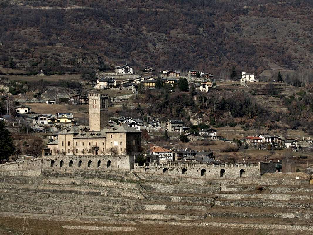
Church of Saints John and Grat. Coming out to the West and returning towards the same meets the Royal Castle or
Château de Sarre; built in 1242 by James Bard, founder of the Lords of Sarre, fù inhabited by the same almost until 1500. Reconstructed almost twice saw the last of these in 1710, while in 1869 Victor Emmanuel II° of Savoy, recently first King Italy, after the purchase turned it completely restored it and keeping the property up to the confiscation of property by the Autonomous Region of Aosta Valley. After, given back at the same age-old Savoy dynasty in the person of Umberto, Count of Sarre. Instead in the hill immediately above are, progressively from the bottom to the top, the
Chapel of St. Bernard at Oveillan-Moron Villages
(853m), that of
San Pietro "Lady of the Angels" at Vareille tiny Hamlet
(1062m) and the
Church of Saint Pantaleon in Ville sur Sarre
(1212m), now on the road to the new Thouraz with the
Chapel of San Teodulo (1652m) and at the entrance to the adjacent Val Clusellaz. Just further to the West
Chapel of Saints James and Margaret marks the border with the Municipality of St. Pierre at the Village of Bellun
(1652m), located on a junction above the ancient
"Via dei Salassi".
Aosta HillAlongside this area, but more to the Southeast, it opens the Hill of Aosta; an area immediately above the Northwest sector of the same that widens from Pont d'Avisod Hamlet
(858m) gradually towards the entrance of the Gran San Bernardo Valley reaching the Fractions of Signayes, Grand Signayes, Arpuilles, Entrebin and Excenex before reaching that of Variney, now in the Municipality of Gignod. Served at the base by a series of asphalt roads that branch off from the State Road n° 27 of the Great St. Bernard, dating vertically in the direction of Pleod, Serrand, Vignole, Vernaillère and Talapé small Villages, crossed by the
"Salassians Via" at an average altitude between
850 / 950 metres; immediately above there is a second tier that involves Rotson, Lin Noir, Lin Blanc, Arpuilles, Charbonne, Entrebin, Crete Benie, Excenex and Meylan Hamlets, placed between the
1370/970 metres. This introduces a top industry now dominated by forests immediately to the East of the deep
"Combe de Labe" and progressively path now only from farms dirt roads; here you will encounter many pastures (Planes, Plan de Dzaou, Chacotteyes, Vernet, Nouva) ending towards the Tsa de Met or Arps Vieilles at the foot of the Col de Metz
(2492m). A good number of paths, usually well signposted, crosses the first two sections; although now rarely visited may offer some nice walks. In the third however only we find the trail
n° 1A, starting from Planes and along the
"Combe de Labe", dates back completely this gorge reaching the Tsa de Met
(2251m). An ancient path to catch up with the herds old
"Arps Vieilles", which until the Eighties was also used by the Alpine Troops to go to practice and training into the same. A beautiful wilderness Tour-Excursion, which becomes more challenging and tiring wanting to reach the hill and from this the Pointes de Metz or Chaligne. Otherwise you can connect with Chaligne Refuge
(1936m) located on the opposite side or North; in this case, starting from Chacotteyes Village
(1713m), and using North trail
n° 2A crossing
"Bois Noir and Combes Deri" (1960m, 2106m) reaching the small saddle
2126 metres and, through short descent, the shelter. Possibility to return to the path
n° 2 through the saddle above
2342 metres towards
"Plan du Debat" and short crossing to the underlying Tsa de Met. This variant is a splendid Tour visiting the entire and complete Eastern Slope of Chaligne Tip.
Gignod AreaGoing in the opposite direction and towards the North and from Aosta with the National Road No. 27 towards the Gran San Bernardo you reach the hamlet of Variney (
782m;
Church of the "Holy Shroud"; Farm "the Myosotis") enters into the Municipality of Gignod (
915/94m; "Maison-strong Arch" and Tour de Gignod). The first built in the twelfth century by the
"Lords De Ginio", while the second has been restored in 1536 in order to build defenses in respect of the
"invasion of Calvinists" into the entire territories of the Aosta Valley. Moreover
Churches of "Our Lady of Protection", San Ilario). From here the road bends more to the Northwest and, leaving left the detour to Condemine and Grand Buthier (
1137m, 1302m; Church of S.S. Margherita Rocco), under the Punta Chaligne, gradually reaches the villages of la Clusaz (
1199m; "Farmhouse La Clusaz"), Echevennoz (
1233/64m; "Hostel Marietty") and finally the Common of Etroubles (
1280m, 15 km. Aosta), placed now beyond the Artanavaz Torrent.
Molte son le caratteristiche di quest'ampia area con presenza di qualche Castello ma di molte Chiese e Cappelle votive disseminate sulla bassa e medio collina.
Logicamente escludendo la Città di Aosta od antica "Augusta Praetoria Salassorum".
Non sono numerose le Torri ed i Castelli che ritroviamo nelle località di Sarre e Gignod, mentre un nugolo di Cappelle votive disseminate sulla collina presso antichi villaggi o nelle vicinanze di punti importanti che segnano la via verso la Montagna confermano la "Cristianità" delle numerose Chiese nei centri maggiomente abitati. Brevemente vediamole:
Area di Sarre
Uscendo da Aosta e verso il Monte Bianco si incontra il Comune di Sarre, dove in località Montan troviamo le Chiese di San Giocondo e "Madonna della Gioia" mentre nel successivo di Chesallet abbiamo la Chiesa di Sant'Eustachio; una breve deviazione dalla Strada Statale ci conduce al Comune di Sarre con la Chiesa dei Santi Grato e Giovanni. Uscendo ad Ovest e rientrando sulla medesima si incontra il Castello Reale o Château de Sarre; costruito nel 1242 da Giacomo di Bard, capostipite dei Signori di Sarre, fù abitato dagli stessi sin quasi al 1500. Ricostruito due volte vide l'ultima di queste nel 1710, mentre nel 1869 Vittorio Emanuele II° di Savoia, da poco tempo primo Re d'Italia, dopo l'acquisto lo trasformò completamente restaurandolo e mantenendo la proprietà fino alla confisca dei beni da parte della Regione Autonoma Valle di Aosta. La stessa lo ridonò alla millenaria dinastia dei Savoia nella persona di Umberto, Conte di Sarre. Invece nella collina subito soprastante troviamo, progressivamente dal basso verso lo alto, la Cappella di San Bernardo presso Oveillan-Moron (853 m), quella di San Pietro "Madonna degli Angeli" a Vareille (1062 m) e la Chiesa di Saint Pantaleon a Ville sur Sarre (1212 m), ormai sulla strada verso la nuova Thouraz con Cappella di San Teodulo (1652 m) ed all'imbocco della Val Clusellaz. Appena più in là ad Occidente la Cappella dei Santi Giacomo e Margherita segna il confine con il Comune di St. Pierre presso il Villaggetto di Bellun (1652 m), posto sull'antica "Via dei Salassi".
Collina d'Aosta
A fianco di questa area, ma più verso Sudest, si apre la Collina di Aosta; una zona subito soprastante il settore Nordovest della medesima che si allarga da Pont d'Avisod (858 m) progressivamente verso l'ingresso della Valle del Gran San Bernardo raggiungendo le Frazioni di Signayes, Grand Signayes, Arpuilles, Entrebin ed Excenex prima d'arrivare a Variney, ormai nel Comune di Gignod. Servita alla base da una serie di strade in asfalto che si dipartono dalla Statale del Grande, risale verticalmente in direzione dei Villaggi di Pleod, Serrand, Vignole, Vernaillère e Talapé, attraversati dalla "Via dei Salassi" ad una quota media tra gli 850/950 metri; subito al di sopra troviamo una seconda fascia che coinvolge i Villaggi di Rotson, Lin Noir, Lin Blanc, Arpuilles, Charbonne, Entrebin, Crete Benie, Excenex e Meylan, collocati tra i 1370/970 metri. Questa introduce ad un settore superiore dominato ormai dalle foreste subito ad Oriente della "Combe de Labe" e progressivamente percorso ormai solo da poderali; qui si incontrano numerosi alpeggi (Planes, Plan de Dzaou, Chacotteyes, Vernet, Nouva) che terminano alla Tsa de Met o Arps Vieilles ai piedi del Col de Metz (2492 m). Un buon numero di sentieri, in genere ben segnalati, percorre le prime due fasce; anche se ormai poco frequentati possono offrire delle belle passeggiate. Nella terza invece troviamo esclusivamente il sentiero n° 1A che, partendo da Planes e percorrendo la "Combe de Labe", risale completamente questa profonda gola raggiungendo la Tsa de Met (2251 m). Un sentiero antico per raggiungere con le mandrie le vecchie "Arps Vieilles", che fino agli Anni Ottanta veniva utilizzato anche dalle Truppe Alpine per andare ad esercitarsi nella medesima. Bella Escursione in ambiente selvaggio, che diventa più impegnativa e faticosa volendo raggiungere il colle e da questo la Pointe de Metz o la Chaligne. Altrimenti é possibile collegarsi con il Rifugio Chalignes (1936 m) situato sul versante opposto o Settentrionale; in questo caso, partendo da Chacotteyes (1713 m), ed utilizzando a Nord il sentiero n° 2A si attraversano "Bois Noir e Combes Derì" (1960 m, 2106 m) raggiungendo la selletta 2126 metri e, tramite breve discesa, il rifugio. Possibilità di rientrare con il sentiero n° 2 attraverso la soprastante sella 2342 metri verso "Plan du Debat" e breve traversata alla sottostante Tsa de Met. Questa variante costituisce splendido Tour visitando tutto il Versante Est della Chaligne.
Comprensorio di Gignod
Proseguendo invece in direzione opposta e verso Settentrione da Aosta con la Strada Statale n° 27 per il Gran San Bernardo si arriva alla Frazione di Variney (782 m; Chiesa del "Santo Sudario"; Agriturismo "le Myosotis") entrando poi nel Comune di Gignod (915/94 m; "Maison-forte Arch" e Tour de Gignod). La prima costruita nel XII° Secolo dai "Signori De Ginio", mentre la seconda é stata restaurata nel 1536 al fine di costruire le difese nei confronti dell' "invasione dei Calvinisti" nell'intero territorio della Valle di Aosta. Inoltre troviamo le Chiese di "Nostra Signora della Protezione" e San Ilario). Da qui la strada piega più a Nordovest e, lasciando a sinistra la deviazione per Condemine e Grand Buthier (1137 m, 1302 m Chiesa di S.S. Margherita e Rocco), sotto la Punta Chaligne, raggiunge progressivamente i Villaggi di la Clusaz (1199 m; "Agriturismo La Clusaz"), Echevennoz (1233/64 m; "Ostello Marietty") ed infine il Comune di Etroubles (1280 m, 15 Km. da Aosta), posto ormai oltre il Torrente Artanavaz.