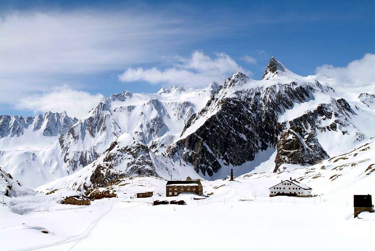
All valleys have a Church or Chapel, a Castle or Tower and even both or a Mountain with hallmarks. Characteristic for each that applies to whole Aosta Valley.For every trip in each of them presents this trio almost unbreakable, because it represents the history, culture and civil-religious (the latter widely spread over the entire territory of the Aosta Valley) traditions in the Centuries and Millennia to the firsts, and meeting to the Eternity for the latest. When we think of a valley, immediately it comes to mind its highest mountain, or more beautiful that inevitably stands as a symbol of that. So for the Mont Blanc or the Grandes Jorasses in the two Courmayeur Vény and Ferret Valleys, Mont Velan and Grand Combins into the Great St. Bernard adjacent Valley, Matterhorn in Valtournanche, Lyskamm in Ayas, Monte Rosa at the Lys Valley or Gressoney, Grand Paradis in Cogne and Valsavarenche, Grande Rousse to Val de Rhêmes, Sassière to Valgrisa and Rutor in La Thuile. But even those
"minor" flaunt their favorite mountain as the Aig. d'Artanavaz, Grand Golliaz, Mont Velan,
Grand Combin, Mont Gelé, Mont Morion,
Mont-de-Berrio, Becca de Luseney, Becca de Viou, Faroma, Aver, Monte Zerbion, Torché in their valleys to the North. A combination that becomes even more distinctive if we add a Church, a Tower or a Castle that represent in terms Religious or what heraldic, chanting the History and the Life of the Population. One aspect that the Mountaineers,
"hasty" to reach the goal and yet ignore the Hikers preferring to leave out the majesty of the views or the exclusive admiration for Nature. Fall in this way into oblivion if not in total anything despite the remaining observations that these may be the key to understand the uses and customs of a place, always a bit different from each other. A total disregard for all that has kept alive a mountain, a valley or just a country. An oversight almost incomprehensible as unforgivable, that we think to regain at least part of reviving the life of mountains with its torrents, always inscrutably still in place, with that of their native
People who live at the base of the same, being born here, living and ending their journey ...
![]()
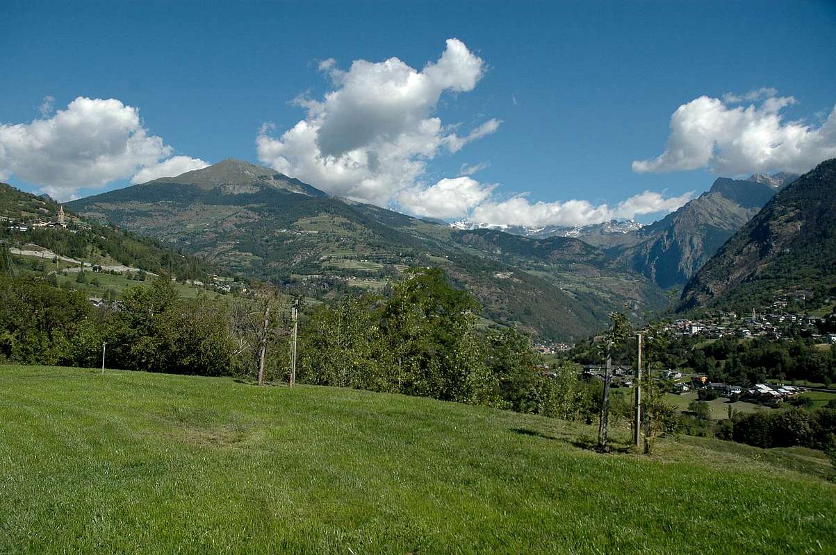
From Ollomont-Posseil towards Aosta & Central Baltea Valley,
by sarme 2006
Tutte le valli hanno Chiesa o Cappella, un Castello, Torre od entrambe ed una Montagna che le contraddistiguono. Caratteristica valida pur per la Val d'Aosta.
Infatti ogni viaggio effettuato in ognuna d'esse presenta questo trinomio quasi indissolubile, poiché rappresenta la storia, la cultura e la tradizioni religiosa (quest'ultima largamente diffusa sullo intero territorio della Valle di Aosta) e civile nei Secoli e nei Millenni per le prime, nonché l'incontro con l'Eternità per l'ultime. Quando pensiamo ad una valle, subito ci viene in mente la sua montagna più elevata o più bella che inevitabilmente si erge a simbolo della medesima. Così per il Monte Bianco o le Jorasses a Courmayeur, Mont Velan e Grand Combins al Gran San Bernardo, Cervino in Valtournanche, Lyskamm ad Ayas, Monte Rosa nella Valle del Lys o di Gressoney, Gran Paradiso a Cogne e Valsavarenche, Grande Rousse in Val di Rhêmes, Sassière a Valgrisa e Rutor a La Thuile. Ma anche quelle
"minori" ostentano la loro montagna preferita come l' Aiguille d'Artanavaz, Mont Vèlan,
Grand Combin, Mont Gelé, Mont Morion,
Mont-de-Berrio, Becca di Luseney e Becca di Viou, Monte Faroma, Becca d'Aver, Monte Zerbion, Becca Torché nelle rispettive vallate a Nord. Connubio che diventa ancor più caratterizzante se acciò aggiungiamo una Chiesa, una Torre o un Castello che le rappresentino sotto il profilo Religioso oppure quello araldico, scandendo la Storia e la Vita di quella Popolazione. Un aspetto che gli Alpinisti,
"frettolosi" di raggiungere la meta ignorano e che pure gli Escursionisti tralasciano preferendo la maestosità dei panorami o l'esclusiva ammirazione per la Natura. Cadon così nel dimenticatoio se non nell'oblio più totale le restanti osservazioni nonostante che queste possano costituire la chiave di volta per comprendere usi e costumi d'una località, sempre un pò diversi l'un dall'altro. Una totale disattenzione per tutto ciò che ha tenuto in vita una montagna, una valle o semplicemente un piccolo paese o villaggio alpino. Dimenticanza tanto incomprensibile quanto imperdonabile e recuperabile almeno in parte riallacciando la vita delle montagne coi loro torrenti, sempre imperscrutabilmente immobili e piazzate al lor posto, con quella delle lor
Genti native che vivon alla base delle medesime, qui nascendo, vivendo e concludendo il loro cammino ...
![]()
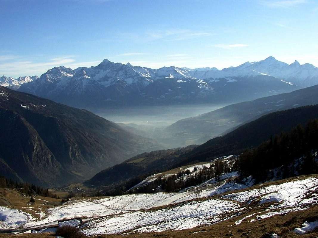
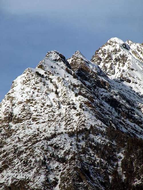
Mont-de-Berrio Punta Fiorio & Mont Morion Chain from South,
by Osw 2016
A Therefore it is necessary to distinguish in two sectors the visit of this valley
that can be done in the day, some parts by car and the remainder on foot, following the course of Rio (Torrent) Artanavaz that, being born at the foot of Malatrà, ending his race reaching the two Buthiers of Ollomont to the North and more towards Northeast with adjacent Valpelline in the location of
Moulin de Variney (784m) between the Rhins Fraction towards Valpelline and the Communes of Roisan Gignod in the South:
First Sector or Northern (Itineraries from 1)- until 3)- ):
A)- Great St. Bernard Valley.
B)- Barasson Vallon. C)-By Basin. D)- Ollomont Valley.
Second Sector or Northeastern (Routes from 5)- till 7)- ):
E)- Valpelline below Mont-de-Berrio and Morions.F)- Oyace and Tornalla's Tower.G)- Bionaz with Place des Moulins Dam.
Towards Ollomont & Valpelline Valleys,
by Osw 2016
Necessaria l'ulteriore suddivisione, separando ciò che é situato a Settentrione del corso del Rio Artanavaz o Buthier de Bosses da quello che si trova collocato maggiormente a Nordest del medesimo colle che inoltre segna il confine con l'adiacente Valpelline. Risulta necessario disgiungere in due settori la visita di questa valle che può essere effettuata in giornata, un pò in auto e per la parte restante a piedi, seguendo il corso dell'Artanavaz che, nascendo alle falde del Malatrà, termina la corsa raggiungendo i Buthiers d'Ollomont e Valpelline nella località di Moulin de Variney (784 m) tra la Frazione di Rhins verso la Valpelline ed i Comuni di Roisan e Gignod a Sud:
Primo Settore o Settentrionale (Itinerari da 1)- fino a 3)- ):
A)- Valle del Gran San Bernardo.
B)- Vallone di Barasson. C)- Conca di By. D)- Valle di Ollomont.
Secondo Settore o Nordest (Vie da 5)- fino a 7)- ):
E)- Valpelline sotto Mont-de-Berrio ed i Morions.
F)- Oyace & la Tour de la Tornalla.
G)- Bionaz con la Diga di Place des Moulins.
![]()
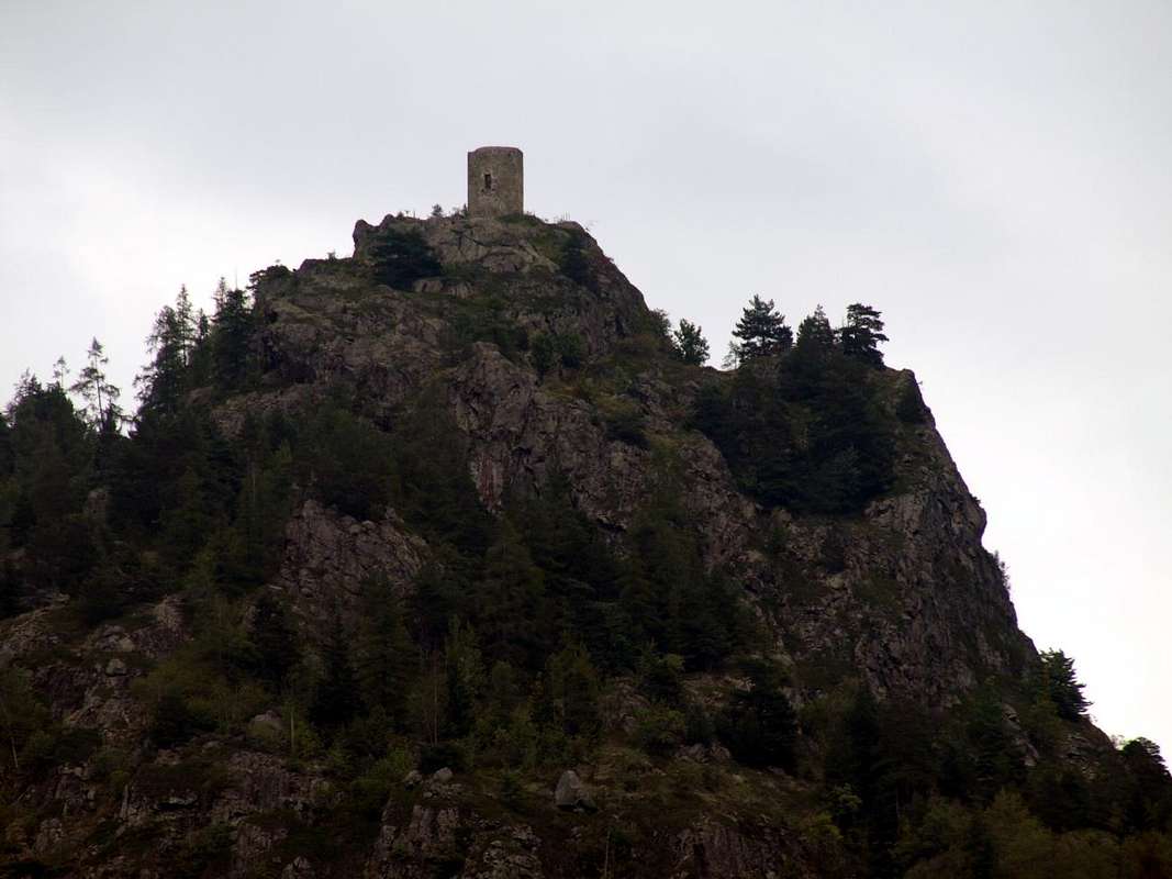
Tour de la Tornalla of 1100 just above Oyace Common,
by Osw 2015
Getting There
By car:
- From TORINO, MILANO, etc: Motorway A5. Exit at IVREA or Quincinetto (PIEDMONT)
From IVREA Town: before in West to Aosta, after in Northwest to Gignod, Etroubles, Saint-Oyen, Saint Rhémy en Bosses Municipalities.
From Courmayeur Resort: before in East to Aosta, after in Northwest to Gignod, Etroubles, Saint-Oyen, Saint Rhémy en Bosses Municipalities.
![]()
Great St. Bernard, by emilius
Specific Roads
From Aosta Town to Gran San Bernardo or Allein and Doues Common in By Basin
From Aosta Town towards the subsequent Variney Fraction (785m) immediately before the Gignod Common (988m) with Great Saint Bernard State Road n° 27; leaving right (North) the alternative towards Allain Commune (1251m); from this reach before Etroubles Commune (1280m) and just after Saint-Oyen Commune (1377m). Continue West up to the entrance of Great St. Bernard Tunnel; abandoning left the same go up in North reaching Saint Rhémy en Bosses Municipality (1632m) now into the upper part of Grand Saint Bernard Valley and, always through the State Road, up to the Grand Saint Bernard Hill (2469m) with the Hospice.
From Aosta City towards Variney Fraction and Gignod Commune (988m) with Great Saint Bernard State Road n° 27 up to the alternative 1074 metres, just before Condemine Hamlet (1137m). Before crossing North the Artanavaz Torrent or Buthier de Bosses after in the Northwest towards Allein Municipality; from the fork 1253 metres nearby this last, always with the Regional Road in Northeast, towards Doues Commune.
![]()
St. Oyen Parish Churc, by Osw
From Allain/Doues to Ollomont/Valpelline Communes with By Basin
From Allein Commune (1251m), with Regional and Municipal Roads, to By Basin; from the entrance of this (various alpages reached by private dirt farms roads), through paths, up to the Mont Saron Southern Antesummit (2681m) and traverse on crest to Tête de la Praz (2751m) and Crou de Bleintse (2824m).
From Doues Commune (1176m), with in asphalt Municipal Road, to By Basin; from this, with paths or dirt roads, to Mont Saron (2681m), Crou de Bleintse (2824m), Letey Refuge below Champillon Pass (2430), Mont Chenaille two Summits (3144m), Tsa d'Ansermin (2388m) and Monte Rotondo (2572m).
From Ollomont Commune (1356m), trhough noumerous paths and variaous upper dirt farms roads, to By Conca; from this various routes in all directions up to the Maria Cristina Rosazza at Savoie Bivouac (2674m).
![]()
Near Allein Common, by Osw
From Aosta Town to Ollomont Common in the homonym Valley
From Aosta City towards Variney Fraction up to the alternative 786 metres (Savin Hamlet); continue North with the Regional Road towards Moulins between the two Torrents Rio Artanavaz also called Buthier de Bosses and Buthier de Valpelline, Rhins, Collin, Creusevy, Chanodaz, Liarey, Fabrique, Chez-les-Chuc Villages reaching in the Northeast Valpelline-Les Ansermins Municipality (996m). At the subsequent crossroads 1059 metres (Chez-Cailleur Hamlet) turn left (North-northwest) reaching Chez-Collet, Clapet, Vesey Villages and Ollomont-Cognen Common (1356m); continue North along the Buthier d'Ollomont towards Rey, Vaud, Glacier or Glassier (1562m) Villages. From this towards the Refuge Franco Chiarella-Amiante (2979m), Filon Alp (2478m), Bonne Mort Pass (2646m), Fenêtre Durand Hill (2797m), Nino Regondi Bivouac (2599m) and Lakes, Tsa de Berrio Alp (2165m), Cormet Hill (2354m) and Breuson Hill (2194m).
![]()
Place Moulins Dam (Bionaz), by Osw
From Valpelline towards Oyace and Bionaz Communes in Valpelline Valley
From Valpelline (580m), with Regional, to Oyace Common (1316-1377m); this to North and South Vallons (Brison, Crête Sèche, Vertsan, Tsa Comba, Grand Chamin Comba, Comba des Lacs and d'Orein up to the entrance into the vallon between Gran Vanna-Braoulé-Bouquetins and Petite/Grande Murailles, below Valpelline Pass.
From Oyace (1377m), with Regional Road, to Bionaz Commune (1612m) and Places Moulin artificial Dam (1970/80m) and Northern and Southern Vallons (Bella Tsa, Combes de Valcornière, Livourneaz, Montagnayes; Vessonaz, Verdonaz, Vieille, Verdzignolaz, Arpisson, Gran Comba and Roisan-Praperiaz Basin. In North: above Ruz Crêtes Sèches Refuge (2389m) under Arolletta small crest and Mont Berlon and Franco Spataro Bivouac (2600m); above Chamen or Chamin Sassa's Bivouac (2973m). From Praz Raye with the Prarayer Refuge (2005m) in Comba d'Orein Nacamouli Refuge (2828m) and Col Collon Bivouac (2818m) at Collon Pass. Towards North: "Capanna" Aosta (2788) at Dent d'Hèrens; North-northeast: Perelli Bivouac (3831m) on Col des Grandes Murailles. East-northeast: Bivouac de la Tête des Roèses (3170m) below the Grandes Murailles and over Paoluccio Bivouac (3582m). East: Fiorio Bivouac (3307m) at Col de Creton. From Oyace or from Valpelline In South or Southeast: Lière Bivouac (2423m) nearby the Arpeyssaou Hill. Valpelline in South-southeast: "Penne Nere" Bivouac (2730m) near Viou Hill and Becca.
- From FRANCE: through the Mont Blanc Tunnel to Entrèves-crossroads to Vény/Ferret Valleys - Mountain Guides of Courmayeur - La Saxe Rock Gym - Courmayeur. By Little Saint Bernard Pass, closed since November until half May to La Thuile Valley - Pré Saint Didier - Courmayeur.
It is not necessary to take Motorway A5: you can drive on State Road n° 26, in the direction of AOSTA - IVREA - TURIN.
By plane:
- Aeroporto Internazionale "Corrado Gex" Saint Christophe (Aosta).
Buthiers Routes & Paths
![]() Buthier de Bosses or de St. Oyen & St. Rhémy-en-Bosses paths,
Buthier de Bosses or de St. Oyen & St. Rhémy-en-Bosses paths,
by Osw 2015
After visiting the hill above Aosta and Gignod Communes, we move decisively further West towards always those of Etroubles, Saint Oyen e Bosses just at the entrance on the long and large Great Saint Bernard Valley, which, however, immediately after discards right (North). Indeed topographically even this large area obliquely addressed Northwest is divided into two distinct parts that mark the transition from Central Baltea Valley to that of Great St. Bernard Pass on the way to these Communes in North-northwest. Even among these is necessary a further division, separating all that is located in the South of the
Rio Artanavaz or Buthier de Bosses from that which is placed in the north of the same hill that also marks the boundary with the adjacent Val Ferret. Therefore it is necessary to distinguish in two sectors the visit of this valley that can be done in the day, some parts by car and the remainder on foot, following the course of Artanavaz that, being born at the foot of Malatrà, ending his race reaching the two Buthiers of Ollomont and Valpelline in the location of
Moulin de Variney (784m) between
Rhins Fraction towards Valpelline and the Municipalities of Roisan Gignod in South:
First Sector or Southern and Northern (Itineraries from 1)- until 4)- ):
A)- Buthier of Chaligne in Val Buthier (
1)- Trip towards the Refuge and Punta Chaligne starting from Condemine locality and through the Villagges of Grand Petit Buthier).
B)- Buthier of Bosses in Great St. Bernard Valley (
2)-Excursion with Snowshoes or by Ski-Mountaineering from St. Rhémy Common up to the Gran San Bernardo Hill).
C)- Buthier of Ollomont into the homonym valley (
3/4)- Ollomont-Cogneins Walk towards Gaula Oratory or Excursion up to Nino Regondi Shelter near the Lakes).
Second Sector or Northeastern and Eastern (Routes from 5)- till 7)- ):
D)- Buthier of Valpelline from Grandes and Petites Murailles (
5/6)- Walk from Oyace to the Tour Tornalla or by Bionaz Trip at Place des Moulins Dam and Prarayer Refuge).
E)- Great Buthier by all reunited Buthiers (
7)- Walk along the ancient
"Via Francigena" from Aosta, Roisan or Gignod Municipalities up to those of Etroubles and St. Oyen).
![]() In winter towards Ansermin Alp above Doues & Valpelline Commons,
In winter towards Ansermin Alp above Doues & Valpelline Commons,
by emilius 2002
Dopo avere visitato la collina sopra i Comuni di Aosta e Gignod, ci spostiamo decisamente verso Occidente verso quelli sempre di Etroubles, Saint Oyen e Bosses insino all'ingresso nella lunga e larga Valle del Gran San Bernardo, che però subito dopo scartiamo a destra (Nord). Topograficamente questa grande area obliquamente rivolta a Nordovest si divide in due distinte parti che segnano il passaggio dalla Valle Centrale della Dora Baltea a quella del Gran San Bernardo sulla via per questi Comuni verso Ovest-nordovest. Anche tra questi é necessaria ulteriore suddivisione, separando ciò che é situato a Meridione del corso del Rio Artanavaz o Buthier de Bosses da quello che si trova collocato a Settentrione del medesimo colle che inoltre segna il confine con l'adiacente Val Ferret. Risulta necessario disgiungere in due settori la visita di questa valle che può essere effettuata in giornata, un pò in auto e per la parte restante a piedi, seguendo il corso dello Artanavaz che, nascendo alle falde del Malatrà, termina la sua corsa raggiungendo i Buthiers d'Ollomont e Valpelline in località Moulin de Variney (784 m) tra la Frazione Rhins verso la Valpelline ed i Comuni di Roisan e Gignod a Sud:
Primo Settore o Sud e Nord (Itinerari da 1)- fino a 4)- ):
A)- Buthier della Chaligne in Val Buthier (1)- Gita al Rifugio ed alla Punta Chaligne partendo dalla località di Condemine ed attraverso i Villaggi di Grand e Petit Buthier).
B)- Buthier de Bosses nella Valle del Gran San Bernardo. (2)- Escursione con Racchette da neve od in Sci-Alpinismo da St. Rhémy al Colle del Gran San Bernardo).
C)- Buthier d'Ollomont nell'omonima valle (3/4)- Da Ollomont-Cogneins Passeggiata all'Oratorio della Gaula od Escursione al Rifugio Nino Regondi presso i Laghi).
Secondo Settore o Nordest ed Est (Vie da 5)- fino a 7)- ):
D)- Buthier di Valpelline dalle Grandes e Petites Murailles (5/6)- Passeggiata da Oyace alla Tour Tornalla o da Bionaz Gita alla Diga Place des Moulins e Rifugio di Prarayer).
E)- Grand Buthier dalla riunificazione di tutti i Buthier (7)- Passeggiata lungo la "Via Francigena" dai Comuni di Aosta, Roisan o Gignod fino a quelli di Etroubles e Saint'Oyen).