
-
 17081 Hits
-
 83.1% Score
-
 16 Votes
|
|
Mountain/Rock |
|---|---|
|
|
48.00629°N / 121.10174°W |
|
|
Download GPX » View Route on Map |
|
|
Chelan |
|
|
Hiking, Mountaineering, Scrambling |
|
|
Spring, Summer, Fall |
|
|
7410 ft / 2259 m |
|
|
Overview
Indian Head Peak is located in the Glacier Peak Wilderness and Wenatchee National Forest just south of Glacier Peak. This peak does not see that many ascents perhaps because of the distance one has to travel to obtain the summit, but I can assure you that it would be worth your while. This mountain should be done as a 2 day trip (although die hards can do it in one making a very long day trip) or can also be done on the way back from climbing Glacier Peak. To White Pass it's about 9 miles, so I assume it's 27 miles round trip to the top. The elevation gain is about 6,000 feet (there's some elevation loss).Standard Route Information (From the North Sauk)
From the Trailhead hike the trail which is about 9 miles to White Pass. On the way there is a junction which says "To Pilot Ridge" which you should ignore and go straight (left) and continue on through the valley. Depending on what time of year you go, sometimes this place can feel like a jungle so don't be surprised if there are lots of bugs. Also the grass and bushes get tall and may cover the trail depending on if trail maintainers came though. At about the half way point is an old cabin (Mackinaw Shelter) which is a great place to rest. From here on out the trail gains most of the elevation to White Pass and switches back up the slope.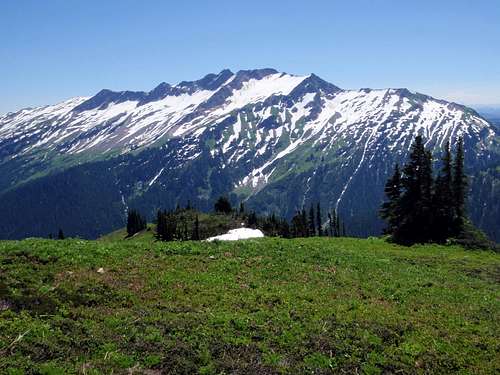
Indian Head Peak from White Pass
Once your at White Pass be sure to take a right (south) which from here you follow along the Pacific Crest trail which travels along the ridge. Then the trail traverses along the bottom of Indian Head, but don't go to far because the turn off is before Indian Pass. Once you find the ridge on the South West face you start heading up it which eventually takes you onto the South Face of the mountain. From here just keep traveling on up until you reach the West ridge, and follow the west ridge most of the way until you get near the summit. Near the summit you cork screw around onto the South East Face which has some loose steep rocks. This is not the place to fall, I had to be cautious on this section and as a test I threw a rock down which seemed to bounce all the way down much of the South Face. Once past here its an easy last walk to the summit.
Getting There
Google Map Directions to the trailhead of Indian Head Peak.Not sure which way is actually faster so I'll give two ways of getting here.
Coming in from the South:
Drive North on I-5 until you get to Everett which you turn onto Highway 2 which after crossing the bridge turn left onto 204 to get to Lake Stevens. From Lake Stevens take a left onto highway 9 (north) until you see Granite Falls Highway (Highway 92) which will be on your right. Take this road until you get to Granite Falls, at Granite Falls the road will seem to end kinda randomly so take a left once you see the high school which now you'll be on the Mountain Loop Highway. Take this road for 37.2 miles until you reach National Forest Road 49 which is past the Bedal bridge. Follow this road until you reach a fork which you take the one on the left which will take you to the trailhead.
Coming in from the North:
Head north on I-5 until you get to Arlington which you get off at exit 208 onto highway 530. From here you drive into the main city of Arlington which for a short section you take a left onto highway 9 and then a right back onto highway 530 again. Stay on highway 530 for 27 miles until you get to Darrington. In Darrington take a right onto the Mountain Loop Highway which you go South for about 18 miles. At National Forest Road 49 you take a left onto it. Follow this road until you reach a fork which you take the one on the left which will take you to the trailhead.
Red Tape
A Northwest Forest Pass is required if parking a vehicle at the trailhead for North Fork Sauk Trail #149.There are no rules or restrictions to climb Indian Head Peak, nor are there permits needing to be filled out.
As for water there are a few locations for getting water:
-When passing the river along the way (for the first 4.5 or so miles you hear the North Fork Sauk River) and cross a bridge which you could filter river water then.
-Also you could filter water at the old shack which is down by the river (5 miles from the trailhead).
-There are some small creeks when traversing the bottom of White Mountain which are good sources for getting water which may be covered up during the winter all the way up to June, but are certainly available in July and early August. These are found almost as White Pass.
-1/4 a Mile South of White Pass there are some camp spots which water can be found there in the small creeks if you know where to look.
-Some ponds along the ridge but not sure how trust worthy they are.
Camping Spots
There is camping near White Pass about 1/4 a mile south along the Pacific Crest Trail, there is also an abandoned cabin half way to White Pass that is also another good alternative. But please don't camp on the meadows nor at White Pass.Weather and Conditions
For the latest weather report click here.It's always good to check if the roads are open or not, View Road Conditions for the trailhead.
For winter conditions check in with the Northwest Avalanche Center.
External Links
Indian Head during late AugustIndian Head During Early August
Redwic - Jan 25, 2011 3:07 pm - Voted 10/10
The peak name...I found the following information posted by the Tacoma Public Library: "This isolated peak, with three small glaciers on its northwest slope, is northeast of Indian Pass near crest of the Cascades, between Indian Creek and the White River in northwest Chelan County. It was named by Forest Supervisor A. H. Sylvester, for a fancied resemblance to a plains Indian headdress."
gimpilator - Oct 16, 2015 11:40 am - Voted 10/10
False SummitIt seems as though most ascent parties go only to the false summit where the register is located. Yesterday I measured the difference with GPS. The east peak is at least 15 feet higher than the west peak. Other parties who have measured the east peak claim it to be 30 to 40 feet higher. This evidence is too strong to be ignored. The register should probably be moved in the future to avoid further confusion.