
-
 16820 Hits
-
 82.48% Score
-
 15 Votes
|
|
Route |
|---|---|
|
|
34.47214°N / 119.71486°W |
|
|
Hiking |
|
|
Spring, Summer, Fall, Winter |
|
|
Half a day |
|
|
class 1 |
|
|
I |
|
|
Overview


 second Mission Creek crossing
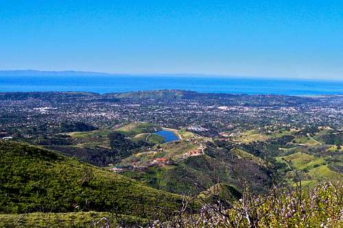
The City of Santa Barbara is sandwiched between the Pacific Ocean on one side and the Santa Ynez mountains on the other. There are at least a dozen trails that take you part way up Santa Ynez Mountains, if not to the top. All of these trails are popular with the local, as well as visiting, nature lovers. If you ask me to name of the most popular trail in all of Santa Barbara, I'd have to say "Inspiration Point Trail."
True to its name, Inspiration Point will inspire you to come back again and again. The trail itself isn't all that different from any of the nearby trails such as Tunnel Trail or Cold Springs Canyon trail. The end of your hike, however, is truly beautiful. Inspiration Point sits on a high point of a rather short hike. You are just high enough to recognize the major structures and landmarks of the city at your feet. The views of the Pacific Ocean and Santa Barbara Channel Islands are truly grand. On a clear day you can see the coast of California in both directions for nearly a hundred miles.
The trail to Inspiration Point passes by many wildflowers and crosses a running creek twice. Don't be surprised to run into many species of birds and snakes. Colorful king snakes and rattle snakes as well as larger animals such as bears, bobcats, dear, coyotes and even mountain lions call these mountains home. Not to worry, although there have been many sightings of these animals, there has never been an attack on humans in our area.
Route Description
 View of Cathedral Peak from Inspiration Point
The hike to Inspiration Point begins the same as Tunnel Trail and Mission Canyon. Hike on a paved service road past a locked gate for about three quarters of a mile and cross a bridge over Mission Creek. Continue hiking to the end of the paved road to where it turns into dirt and intersects a dirt service road from the right. Keep to the left and hike a quarter of a mile to Mission Creek. There are swimming holes and a rough trail that can take you up along the creek to several small and large waterfalls. If you choose to explore off the main trail, however, look out for poison oak as they grow in abundance near the creek. Back to the main trail, cross the creek on rocks and boulders and continue straight ahead on the main trail to Inspiration Point. Continue on switchbacks through the most pleasant part of the trail to intersect a fire road in about three quarters of a mile from the second creek crossing. Cross the fire road and shortly after there is no more uphill. This is Inspiration Point.
How to get there

From US Highway 101 in Santa Barbara take the Mission Street off ramp and turn right at the light. Continue on Mission street passing in front of the mission building to a stop sign at the intersection with Foothill Road. Turn right onto Foothill Road and left onto Tunnel Road. You will come to a fork. Take the left fork and drive all the way to the end. You can park on the right hand side of the road within the white lines. Additional parking may be found before the end of the road. Please do not park in the side streets. They are all private roads.
Essential Gear
A Good pair of hiking shoesExternal Links
Santa Ynez mountainsChannel Islands