Intro
Koszysta, Kosista 2193
The highest peak in a lateral ridge separating vallleys of Panszczyca and Waksmundzka .
![Koszysta Tooltip for IE: Koszysta]()
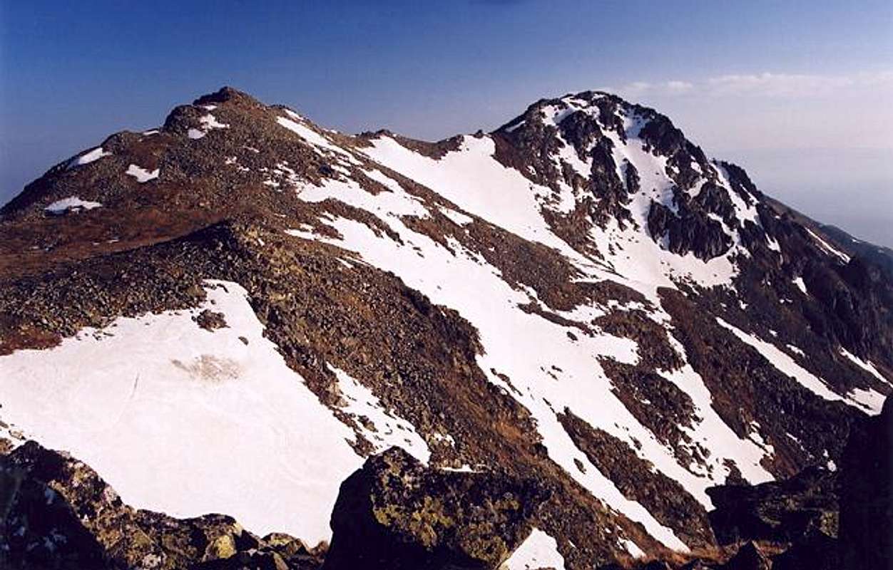
Koszysta from Wielki Woloszyn peak
The massif neighbours via Krzyzne Pass with nearby
Woloszyn ridge and Buczynowe Turnie crags in the famous ridge of Orla Perc (Eagles’ Path).
Though easily accessible rather rarely visited by tourists (no marked routes), no serious alpine climbing challenges in the whole massif, a real wilderness, Tatra National Park strict natural reservation.
Great panoramas from the ridge, good ski touring possibilities.
The origin of the name of the peak is not clear.
Till the half of 20th century the whole area was a terrain of sheperd’s activity so the information about who was the first Wielka Koszysta ascender just can’t be proved.
First known tourist ascent:
3.VIII.1838 – Ludwik Zejszner and companions
First winter ascent:
4.III.1910 – Henryk Bednarski, Jozef Lesiecki, Mariusz Zaruski and Stanislaw Zdyb
Koszysta (2193)
![Koszysta Tooltip for IE: Koszysta]()
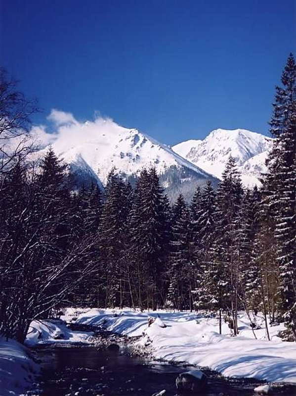
Koszysta(on the right) from Lysa Polana
The long and massive
Koszysta ridge separates valleys of
Panszczyca(west) and
Waksmundzka(east).
The ridge starts its run around the saddle of
Krzyzne Pass(2113) and goes north to turn slightly north-east in the final section.
Going from Krzyzne Pass one can distinguish in the ridge a few quite prominent culminations, these are:
Waksmundzki Wierch(2186)
Wielka Koszysta(2193) – the main summit
Mala Koszysta(2014)
On the north Koszysta Massif meets the group of lower foresty peaks of Ostry Wierch and Gesia Szyja(1489) (famous viewpoint) via wide
Waksmundzka Rowien pass(1418) .
A bit west from Waksmundzka Rowien expands great meadow of Waksmundzka Polana (popular marked route) .
Getting There
First of all you have to get to Zakopane town on Polish side of Tatra Mountains – very good communication links with Cracow City(international airport) and the rest of Poland.
PKS Cracow – Zakopane bus departures
PKP - Polish Railways connection search
PKS Zakopane - buses
Cracow Airport
Then ,when planning climbing peak of Wielka Koszysta your target is to reach the saddle of Krzyzne Pass(2113)
– there are 2 ways of getting there by marked routes.
First one is yellow marked route from Hala Gasienicowa through beautiful Panszczyca valley, the second variant leads from Five Polish Lakes’ valley.
Routes Overwiev
No marked routes in Koszysta massif.
Marked Routes of the area :
Zakopane – Kuznice
Numerous bus connections (1/2 h on foot from railway station)
Zakopane – Palenica Bialczanska (the road to Morskie Oko lake)
Numerous bus and minibus connections (25 km)
Kuznice(1010) – Dolina Jaworzynka - Hala Gasienicowa(1500)
Yellow Marks ,5 km ,1 ½ h ,550 meters of altitude difference
Kuznice – Boczan – Hala Gasienicowa
Blue marks ,5 km ,1 ½ h ,550 m of AD
Hala Gasienicowa – Dubrawiska – Panszczyca Valley – Krzyzne Pass(2113)
Yellow Marks ,6 km ,2 ½ h ,over 700 m of AD
Palenica Bialczanska(990) – Wodogrzmoty Mickiewicza waterfalls(1100)
Road ,3 km ,3/4 h
Wodogrzmoty Mickiewicza waterfalls – Roztoki Valley – Five Polish Lakes’ mountain chalet(1671)
Green marks ,6,5 km ,2 ½ h ,640 m of AD
Five Polish Lakes’ chalet – route crossing at Czerwona Mlaczka – Buczynowa Valley(threshold) – Krzyzne Pass
Blue and yellow marks ,3,5 km ,3 h ,ca.700 m of AD
After reaching Krzyzne Pass You start a slight walk up north along the wide ridge to the top of nearby Waksmundzki Wierch(2186) peak and further marching by the ridge to well seen Wielka Koszysta(2193) summit – the highest point of the massif (about 40 minutes of easy hike from the pass).
![Czerwony Staw lake (Red Lake)...]() Czerwony Staw(Red Lake) in Panszczyca valley
Czerwony Staw(Red Lake) in Panszczyca valleyKoszysta Area - Map
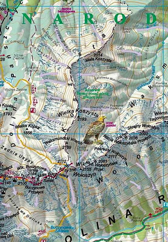
![Koszysta Tooltip for IE: Koszysta]() Tatry Wysokie (High Tatra) map, in scale 1:25 000, description in 6 languages, ISBN 83-87873-26-8, available in all shops and book stores in Zakopane. Here you can check the net version
Tatra Maps (English version)
Tatry Wysokie (High Tatra) map, in scale 1:25 000, description in 6 languages, ISBN 83-87873-26-8, available in all shops and book stores in Zakopane. Here you can check the net version
Tatra Maps (English version)
Red Tape
It is Tatra National Park (TPN) area ,watch out for alpine climbing and hiking restrictions.
Hiking is allowed only on marked routes.
Stay always respectful to mountain nature !
TPN - Tatra National Park
When To Climb
You can climb/hike all year round.
Theoretically the best weather conditions: late August – October
June/July frequent t-storms.
In winter usually serious avalanche danger (check : TOPR – Daily Avalanche Forecast )
Camping
Lots of accomodation possibilities in Zakopane and area.
The choice of offers is great and differentiated from expensive, luxury hotels to guest houses, private rooms, youth hostels and camping sites.
There is also no problem with finiding a place to sleep on Slovak side of course, place like Zdiar can be a good base when thinking about Koszysta climb (bus communication to the border).
Polana Zgorzelisko Hotel
Mountain chalets in the area :
Murowaniec Chalet
Mountain Chalet in Five Polish Lakes’ valley
Stara Roztoka Chalet
All these mountain chalets are open all year round.
Camping in Tatra National Park is strictly forbidden.
Mountain Conditions
Severe and changeable high mountain climate ,be always prepared for sudden weather breakdowns.
TOPR – Tatra Mountain Volunteer Rescue(Poland)
Rescue Phone Number: (+48) 601 100 300
TOPR – Daily Avalanche Forecast
External Links
 7735 Hits
 89.01% Score
 28 Votes
 Koszysta from Wielki Woloszyn peak
The massif neighbours via Krzyzne Pass with nearby Woloszyn ridge and Buczynowe Turnie crags in the famous ridge of Orla Perc (Eagles’ Path).
Though easily accessible rather rarely visited by tourists (no marked routes), no serious alpine climbing challenges in the whole massif, a real wilderness, Tatra National Park strict natural reservation.
Great panoramas from the ridge, good ski touring possibilities.
The origin of the name of the peak is not clear.
Till the half of 20th century the whole area was a terrain of sheperd’s activity so the information about who was the first Wielka Koszysta ascender just can’t be proved.
First known tourist ascent:
3.VIII.1838 – Ludwik Zejszner and companions
First winter ascent:
4.III.1910 – Henryk Bednarski, Jozef Lesiecki, Mariusz Zaruski and Stanislaw Zdyb
 Koszysta(on the right) from Lysa Polana
The long and massive Koszysta ridge separates valleys of Panszczyca(west) and Waksmundzka(east).
The ridge starts its run around the saddle of Krzyzne Pass(2113) and goes north to turn slightly north-east in the final section.
Going from Krzyzne Pass one can distinguish in the ridge a few quite prominent culminations, these are:
 Tatry Wysokie (High Tatra) map, in scale 1:25 000, description in 6 languages, ISBN 83-87873-26-8, available in all shops and book stores in Zakopane. Here you can check the net version
Tatra Maps (English version)


