


-
 2524 Hits
-
 79.78% Score
-
 11 Votes
|
|
Area/Range |
|---|---|
|
|
45.87920°N / 7.23422°E |
|
|
Hiking, Mountaineering, Trad Climbing |
|
|
Spring, Summer, Fall, Winter |
|
|
12251 ft / 3734 m |
|
|
Note
La montagna chiama i suoi figli, ed essi rispondono fedelmente al suo appello… Osvaldo Cardellina, Diario alpinistico, 1964-65 Page texts: @ OsvaldoCardellina "Osva", passed away on May 2, 2022. Page owners: Christian Cardellina e Osvaldo Cardellina. Any updates from September 12, 2022: Antonio Giani, page administrator, friend and climbing companion. Testi della pagina: @ OsvaldoCardellina "Osva", scomparso il 2 maggio 2022. Proprietari pagina: Christian Cardellina e Osvaldo Cardellina. Eventuali aggiornamenti dal 12 settembre 2022: Antonio Giani, amministratore della pagina, amico e compagno di salite. |
Menouve Overview Molline
Pictures in page are by Emilio Bertona also emilius, Antonio Giani aka Antonio & Osvaldo Cardellina or Osw
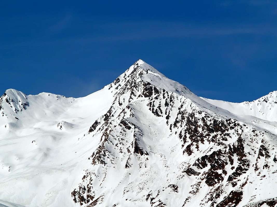
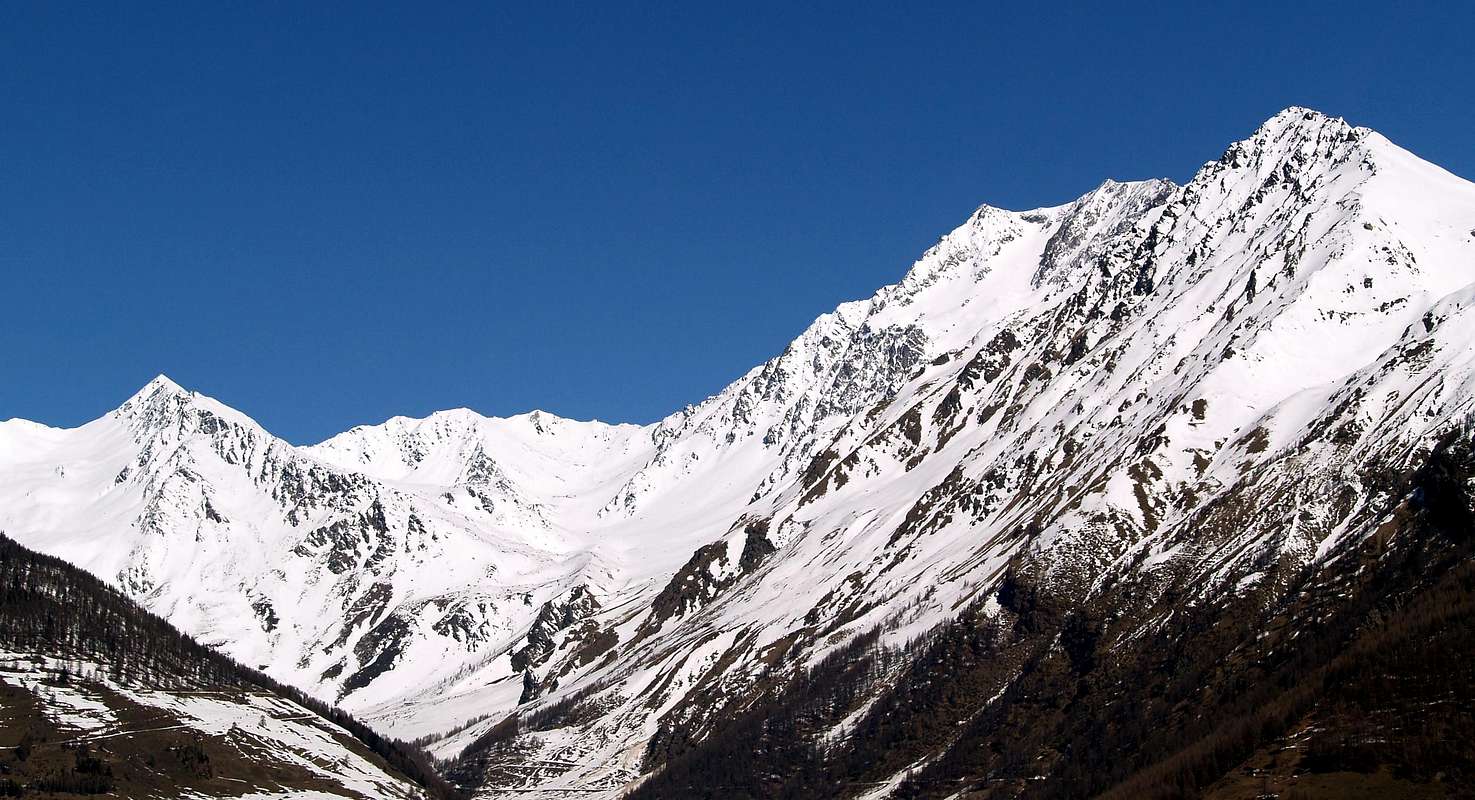
Perpendicular to the Valley of Great Saint Bernard constitutes a her Eastern branch. Starting North from the border with Switzerland and to Artanavaz Torrent. This last is also known as Buthier des Bosses, with the name that distinguishes many Buthiers or Torrents of Valle del Gran San Bernardo, in the adjoining Ollomont and the most Eastern of Valpelline. But, between the median part of the San Bernardo (to the West) and the Menouve Valley or Měnový, East and above the Village of Etroubles. Which, in turn, is split by sending a branch to the left (North-northwest) with the same name and more large, while the right (North-northeast), shorter in extension; it is called Molline. But both lead to the South reaching the small Village of Prailles Dessous, Bezettes locality (1.629m), just above Municipality of Etroubles (1.280m), just nearby the "Rio" Artanavaz in valley floor. Until not long ago they were traveled by smugglers of cigarettes or frequented almost exclusively by hunters and chamoises poachers; while today meet both groups devoted to hiking to skiing to mountaineering or snowshoeing (in the lower parts, for in those high there are high risks of avalanches or, more simply, snowslides. During the summer you can make easy ascents to Punta Barasson (2.963/6m) or in its surroundings as sull'Arête des Tcholaires (2.857, 2.805, 2.801, 3.051, 2.953, 3.020, 3.033, 3.060 meters) to the Northeast, while the West Ridge of Mont Velan (3.734m), starting from Colle d'Annibale or Hannibal Pass (2.962m), it requires care and a bit of experience. In any case they must comply with all due caution; especially in bad weather and in winter ... where also the new Refuge-Bivouac Molline is always closed.
 |
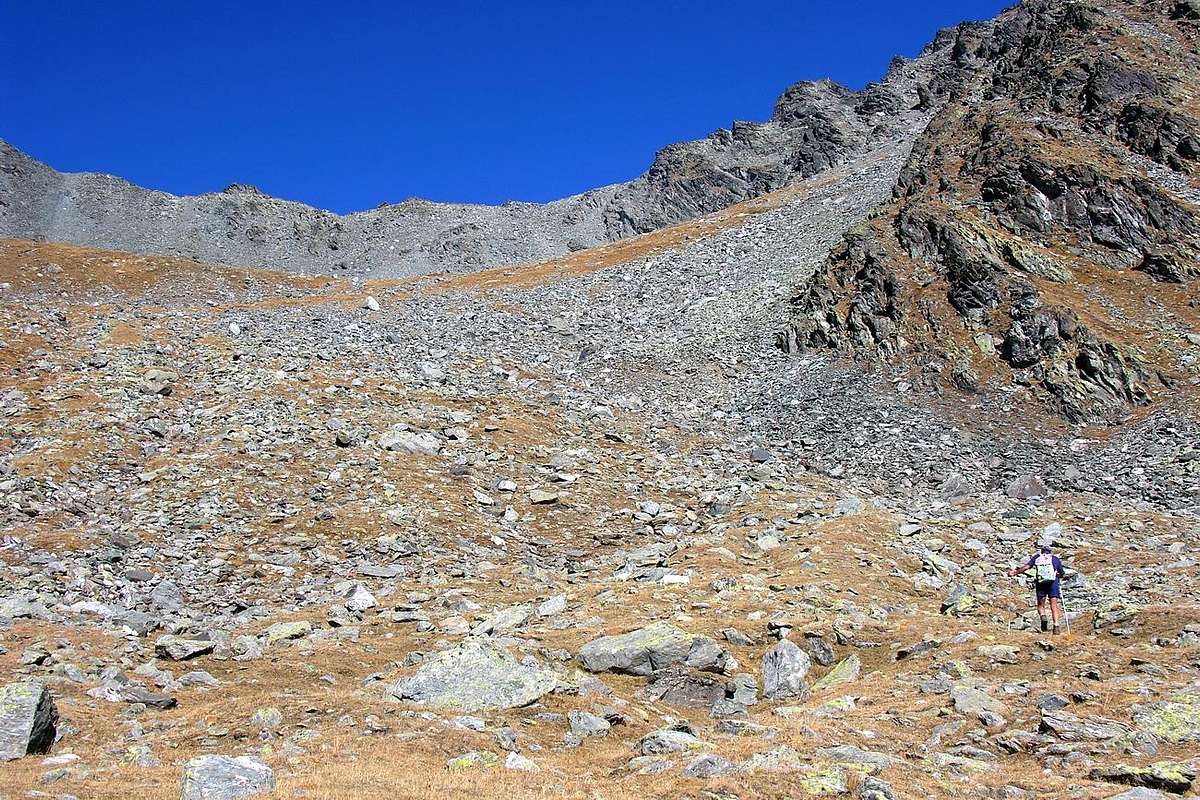 |
Vallata laterale e perpendicolare a quella del Gran San Bernardo costituisce ramo a se stante. Da Settentrione dal confine con la Svizzera e verso il Rio Artanavaz. Quest'ultimo é anche conosciuto come Buthier des Bosses, con il toponimo che contraddistingue molti Buthiers o Torrenti dell'intera Valle del Gran San Bernardo, dell'attigua di Ollomont e di quella più Orientale della Valpelline. Ma, compreso tra la parte mediana del San Bernardo (ad Ovest) ed il Vallone di Menouve o Menovy, ad Oriente e sopra l'abitato di Etroubles. Il quale, a sua volta, si sdoppia inviando un ramo a sinistra (Nord-nordovest) con lo stesso nome ed anche più largheggiante, mentre quello di destra (Nord-nordest), più breve in estensione, viene chiamato Vallone di Molline. Ma entrambi, poi riunificandosi, sfociano verso Sud raggiungendo i piccoli abitati di Prailles Dessous, località Bezettes (1.629 m), appena al di sopra del Comune di Etroubles (1.280 m), immediatamente vicinore al "Rio" Artanavaz, che scorre verso Sudest nel fondovalle. Fino a non molto tempo fa erano percorsi dai contrabbandieri di sigarette oppure frequentati quasi esclusivamente da cacciatori e bracconieri; mentre oggidì s'incontrano comitive dedite sia all'escursionismo che allo sci-alpinismo od alle racchette da neve (nelle parti inferiori, poiché in alto vi sono elevati pericoli di valanghe o, semplicemente, di slavine. Durante la bella stagione si possono compiere facili ascensioni alla Punta di Barasson (2.963/6 m) o nel suo circondario come sull'Arête des Tcholaires (2.857, 2.805, 2.801, 3.051, 2.953, 3.020, 3.033, 3.060 m) verso NE, mentre la Cresta Occidentale del Mont Velan (3.734 m), con partenza dal Colle d'Annibale (2.962 m), richiede una certa prudenza ed un pò d'esperienza. In ogni caso si debbono osservare tutte le dovute cautele; soprattutto nella cattiva stagione ... dove, inoltre, il nuovo Rifugio-Bivacco Molline é sempre chiuso.
 |
 |
 |
 |
 |
Getting There
BY CAR:
- From TORINO, MILANO, etc: Motorway A5. Exit at IVREA or Quincinetto (PIEDMONT) From IVREA Town: before in West to Aosta, after in Northwest to Gignod, Etroubles, Saint-Oyen, Saint Rhémy en Bosses Municipalities. From Courmayeur Resort: before in East to Aosta, after in Northwest to Gignod, Etroubles, Saint-Oyen, Saint Rhémy en Bosses Municipalities.
- Specific Road From Aosta Town towards the subsequent Variney Fraction (785m) immediately before the Gignod Common (988m) with Great Saint Bernard SS.27; leaving right (North) the alternative towards Allain Commune (1.251m); from this reach before Etroubles Commune (1.280m) and just after Saint-Oyen Commune (1.377m). Continue West up to the entrance of Great St. Bernard Tunnel; abandoning left the same go up in North reaching Saint Rhémy en Bosses Municipality (1.632m) now into the upper part of Grand Saint Bernard Valley and, always through the State Road, up to the Grand Saint Bernard Hill (2.469m) with the Hospice.
- From FRANCE: through the Mont Blanc Tunnel to Entrèves-crossroads to Vény/Ferret Valleys - Mountain Guides of Courmayeur - La Saxe Rock Gym - Courmayeur. By Little Saint Bernard Pass, closed since November until half May to La Thuile Valley - Pré Saint Didier - Courmayeur. It is not necessary to take Motorway A5: you can drive on SS.26, in the direction of AOSTA - IVREA - TURIN.
BY PLANE:
- Aeroporto "Corrado Gex" Saint Christophe (Aosta).
Approaching
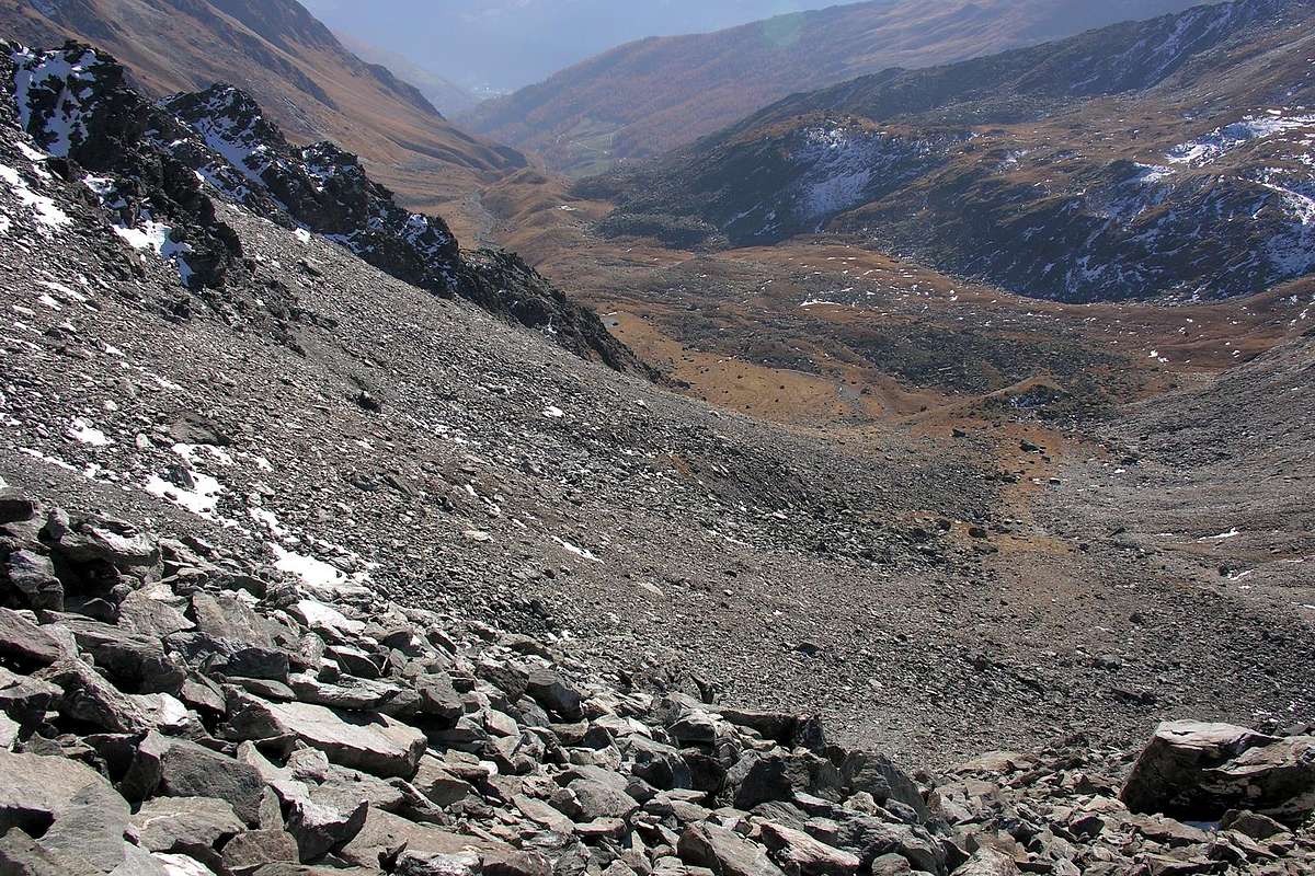
Menouve or Menovy small Valley: from Prailles Dessous-Quaye small Village (signal no) towards Menouve Pastures (1.913m), with farms dirt road; with path n° 21 to Trecaoudette Alp (2.133m), in North to Tsa de Menovy (2.243m) in West Tsa Nouva. Continue, trail n° 21, to Southern Menovy, or better known as Menouve, Pass (2.758m). Molline small Valley: from Menovy with unnumbered path-traces to L'Arvus Alp (1.983m). Leaving left (Northwest) the Menouve Vallon to Molline Alp (2.295m; old alp with ruines), on grassy promontory adjacent Molline Bivouac (2.415m) near Alp, with small path n° 21 in Northwest
1) - Molline Pass (2.915m), with not signed path but traces; in North to the overlying
2) - Hannibal Pass (2.992m), between Velan (3.734m), West Crest, and Testa Grisa (3.060m), through little traces, debris, blocks and easy broken rocks.
Menouve o Menovy Vallone: dal Villaggetto di Prailles Dessous-Quaye (segnale di divieto di transito con i mezzi, se non autorizzato) verso l'Alpe di Menouve (1.913 m), tramite la strada poderale sterrata; con il sentiero n° 21 all'Alpe Trecaoudette (2.133 m), quindi a Settentrione in direzione dell'Alpeggio o Tsa de Menovy (2.243 m) ad Ovest della Tsa Nouva (2.426 m). Continuare, sentiero n° 21, verso il Passo Meridionale di Menovy od anche, più conosciuto da cacciatori e contrabbandieri siccome Colle di Menouve, (2.758m). Valloncello di Molline: da Menovy o Menouve, tramite sentiero-tracce non numerate, sino alla grande Alpe dell'Arvus (1.983 m). Abbandonando sulla sinistra (Nord-nordovest) il Vallone di Menouve si raggiunge su di un promontorio erboso l'Alpe Molline (2.295 m; resti di baita con rovine), all'adiacente Bivacco di Molline (2.415 m) presso l'alpe medesima Sempre con sentierino n° 21 verso Nordovest al
 |
 |
|
1) - Colle di Molline (2.915 m), tramite sentiero non segnalato ma tracce; in direzione Nord al soprastante
2) - Colle d'Annibale (2.992 m), tra il Mont Velan (3.734 m), Cresta Occidentale, e la vicina Testa Grisa (3.060 m), attraverso piccole tracce, detriti, blocchi e facili roccette da scavalcare.
Campings
Remember that free camping is forbidden (except for emergency reasons, over 2.500m, from darkness until dawn).
Mountain Conditions
- You can get meteo information at the official site of the Regione Valle d'Aosta:
- Valle d'Aosta Meteo
Books and Maps
BOOKS:
- "Guida delle Alpi Occidentali", di Giovanni Bobba e Luigi Vaccarone C.A.I. Sezione di Torino Volume II (parte II), 25 Maggio 1896.
- "Guida dei Monti d'Italia-Alpi Pennine" (Vol.I°) di Gino Buscaini-Club Alpino Italiano/Turing Club Italiano, Luglio 1971 (in Italian).
- "Diari Alpinistici" di Osvaldo Cardellina e Indice Generale accompagnato da Schedario Relazioni Ascensioni 1964-2019 (unpublished).
 |
 |
 |
MAPS:
- Kompass "Monte Bianco Valle d'Aosta Sentieri e Rifugi" Carta turistica 1:50.000.
- L'Escursionista "Gran San Bernardo Ollomont" Ed. Rimini (n° 5) 1: 25.000.
Important Information
- REGIONE AUTONOMA VALLE D'AOSTA the official site.
- FONDAZIONE MONTAGNA SICURA Villa Cameron, località Villard de la Palud n° 1 Courmayeur (AO) Tel: 39 0165 897602 - Fax: 39 0165 897647.
- SOCIETA' DELLE GUIDE DELLA VALPELLINE Etroubles-Strada Nazionale, n° 13 - Tel +39 0165 78559 - Valpelline-Loc Capoluogo, n° 1 - Tel +39 0165 713502 (AO) Italia.
- A.I.NE.VA. (Associazione Interregionale Neve e Valanghe).
 |
Useful numbers
- Protezione Civile Valdostana località Aeroporto n° 7/A Saint Christophe (Ao) Tel. 0165-238222.
- Bollettino Meteo (weather info) Tel. 0165-44113.
- Unità Operativa di Soccorso Sanitario Tel. 118.