
|
|
Route |
|---|---|
|
|
36.00000°N / 74.00000°E |
|
|
Hiking, Mountaineering, Mixed |
|
|
Spring, Summer |
|
|
A few days |
|
|
Moderate |
|
|
Minapin – Rakaposhi Base Camp
Minapin is located on the left side of the Hunza River, can be reached by some one hour hiking from Pisan (2445m), and located on the Karakoram Highway. A guest house at Minapin is available. The best period for this route is May to September each year.

Rakaposhi
From Minapin follow the route that is seeing climbing south just behind the guest house. For the first only some kilometers the ascent is vertical and tough, it crosses the incurable moraine of the Minapin Glacier. As you move forward more, keeping to the left of the glacier, the entire Rakaposhi-Diran ridge line comes into sight. After another 6 hours hike you come to tiny cabin where the night can be spent. The route continues along the left side of Minapin Glacier and at last arrives at a green pasture; this is the base camp for Rakaposhi (7788m). The Rakaposhi peak can also be reached from Jaglot and the base camp can be established west of Rakaposhi in the Biro Glacier basin.
Getting There
Gilgit can be reached from Islamabad by air or by road along the Karakoram Highway. From Gilgit find a local van, jeep or bus or hire a private van or jeep Pisan or for Karimabad Hunza, Baltit,. Baltit, Aliabad, Karimabad and Ganesh are located close to each other. Karimabad locates overlooking the Karakoram Highway; it is a tourist town with modern hotels, eating places and other facilities, like telephone and internet.

Hunza Valley, Pakistan
It also provides a panoramic views of Hunza valley as well as Rakaposhi (7788m) Diran (7257m), south of the river, and Hachindar Chish (7163m), Ultar Peak (7329m) and Ultar Glacier on the north side of the river. At Baltit there is an 8th century fort perched high on a ridge. Another old fort is situated at Altit, near Baltit, a village across of Ultar stream.
Route Description
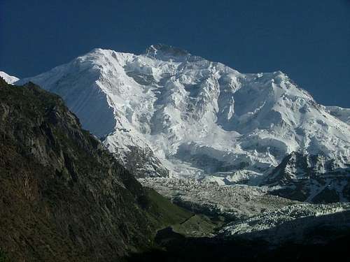 Mount Rakaposhi (7788-m)
From Minapin follow the route that is seeing climbing south just behind the guest house. For the first only some kilometers the ascent is vertical and tough, it crosses the incurable moraine of the Minapin Glacier. As you move forward more, keeping to the left of the glacier, the entire Rakaposhi-Diran ridge line comes into sight. After another 6 hours hike you come to tiny cabin where the night can be spent. The route continues along the left side of Minapin Glacier and at last arrives at a green pasture; this is the base camp for Rakaposhi (7788m). The Rakaposhi peak can also be reached from Jaglot and the base camp can be established west of Rakaposhi in the Biro Glacier basin.
Essential Gear
Basic Mountaineering and Hiking gears are required.