
|
|
Mountain/Rock |
|---|---|
|
|
46.67960°N / 122.2229°W |
|
|
Lewis |
|
|
Hiking |
|
|
4060 ft / 1237 m |
|
|
Overview
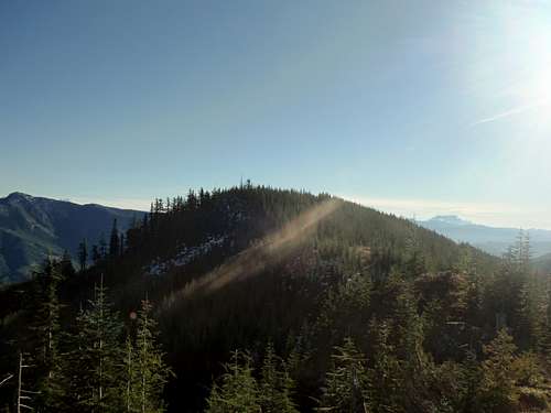
The summit of Mount Goodie is on the left. Seen from Sprialtop on 7/25/13.
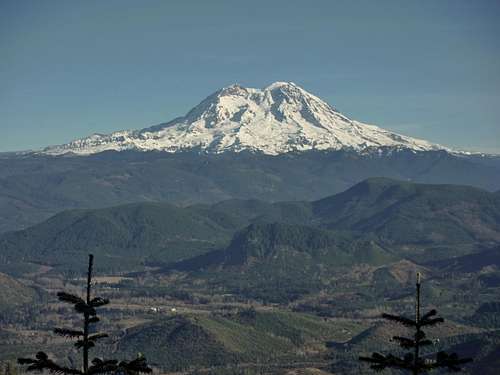
The legendary views of Mount Rainier
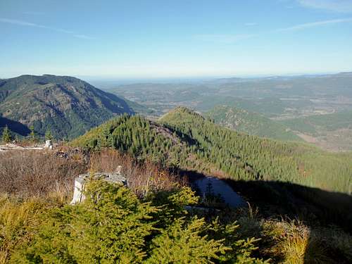
It should be noted that there is no complete panorama on this summit however there are a number of great viewpoints while heading up to the summit. Among the best views from this summit are to the western foothills, notably towards peaks called Ladd Peak and another called The Rockies. Once you a top switchback you have stunning views of Mount Rainier. The Mount Rainier views clearly are the highlight of the trip and you will probably will have a quarter of your pictures being pictures of Mount Rainier. Near the end of the road within a view feet of the summit lies excellent views of Mount Saint Helens. The best views of Mount Adams which can seen over Mount Storm King can be seen on the very true summit which overlooks a bushy cliff.
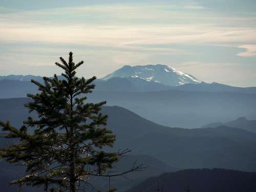
Mount Saint Helens from Mount Goodie
Also unlike the northern Cascade classic Mount Goode, the trip up this Mount Goodie is just a easy four mile roundtrip and 900 foot elevation gain road walk to the summit. If you don't mind drive a little ways on a decent gravel road you find a hard to find overgrown roadwalk on your left. Though the travel is starting to become overgrown by slide alder as of 2013 this road is fairly easy to walk to the within feet of the true summit. The true summit is just literally a 30 foot bushwhack/ simple scramble from the logging road. Unfortunately we did not find a summit log on Mount Goodie.
Looking from a northern subpeak of Mount towards the true summit of Mount Goodie.
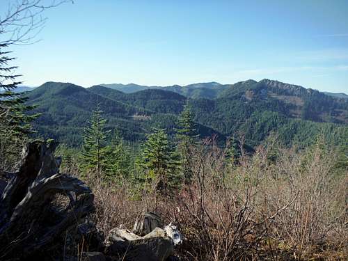
It should be noted that though the true summit of Mount Goodie is home to excellent so is two subpeaks on the northern ridge. In fact some would argue that these views are just as good if not better than the true summit. These summit are located right of the main logging road to the summit. The sub-peak which is closest to the true summit is home to 100 foot Class 2 scramble and bushwhack to that false summit which will give you close up views of the true summit of Mount Goodie. The sub-peak located just a couple hundred feet to the north gives great views towards an obscure tarn lake as well as the entire northern ridge of Mount Goodie along with Spiraltop. There is brief logging that leads within feet of this sub-peak and short scramble will lead you to these excellent views. Both of these sub-peaks also have amazing views of Mount Rainier.
Looking down the northern ridge of Mount Goodie toward Spiraltop. Notice how much taller Mount Goodie is compared to Sprialtop.
Getting There
FROM THE SEATTLE-TACOMA METRO AREA: From route 512 just west of Puyallup you want to take Route 7. Twenty miles down the road there is a detour which send you through the town of Eatonville. From there follow the detour all of the way to Lake Alder where you will pick back up Route 7 and take it to Elbe. From Elbe Washington take Route 7 South roughly five miles south. Take a right (west) onto Forest Road 74 and take that about two miles. Veer to the left on the first major logging pass. About a mile up you will want to veer left again. Continue up the road roughly 4 miles more all the way to a the beginning of the sharp turn at about 3245 of elevation. The poorly marked logging road trail will be on your left. It will look like it is full of slide alder but this is a false appearance because there is a path through it. There is a pullout just 50 feet to the north of the hard to notice road. You will know you went too far if you run into a well developed logging road roughly 300 feet to the south. Park along the side so that potential trucks can get through if needed.Map of the Route and Road to the Trailhead
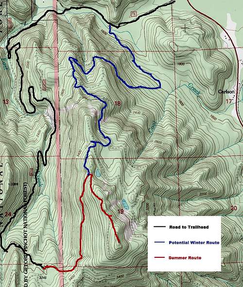
Map of Mount Goodie. Note the map of the road to the trailhead along the winter and summer routes on the map.
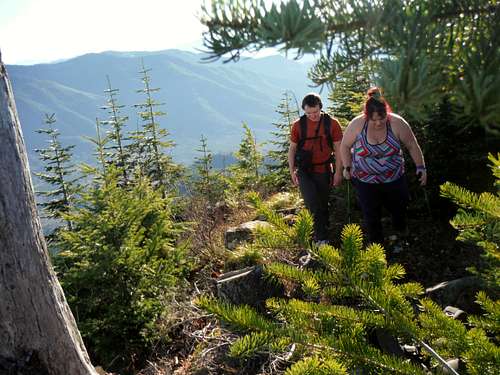
Josh Lewis and BearQueen heading up to the true summit of Mount Goodie.
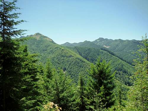
Looking east toward the mountains to the west while going up Mount Goodie
Red Tape
There is no red tape on this trail at any time of the year.When to Climb
Spring summer and fall is probably the best time to climb this mountain if you are looking for the least amount of effort. It should be noted though that though the trip will be much longer this mountain can be attempted in winter provided one can navigate through the somewhat confusing set of logging roads. The terrain is gentle enough for a long but very doable trip up to scenic summit of Mount Goodie. See the map for a possible winter route.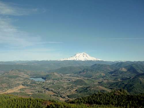
Classic view of towering Mount Rainier, Mineral Lake and the town of Mineral from a subpeak of Mount Goodie.
Camping
When my party was up there we saw no signs preventing camping on the mountain. There were a number of nice potential spots higher up on the mountain including on the highest part of the road within a few feet of the summit. If I would stay overnight I would at this section.External Links
SP Member's Eric Willhite Webpage on Mount GoodieMount Goodie List of John Page