Ma pure un viaggio verso la "Cristianità". Certamente, poichè questi luoghi hanno visto crescere il culto del Cristianesimo, come testimoniano santuari, oratori, chiese e cappelle votive, un pò disseminate ovunque sul territorio. Un discorso che, viaggiando da Ovest verso Est, ci fà transitare per il famoso
del 1200 (non molto sopra il Comune di Saint Marcel con la sua Chiesa Parrocchiale costruita sopra l'antica Cappella di San Rocco del 1630 ed i resti del Castello dei Conti di Challant costruito nel 1600 da Giacomo di Challant, nonché le antiche miniere di rame di Chuc-Servette allo ingresso della
gestita dal Marchese Attilio Turati ed ex Riserva del Barone Giuseppe Antonio Beck Peckoz di Gressoney). Per poi trovare a
ad opera di Aimone di Challant con le sue torri sostenute da mura merlettate, nonché la Chiesa parrocchiale con il Campanile con cuspide ed allo interno la
in legno, del 1500. Oltre si arriva a Pontey alle pendici del Mont Barbeston, dove nella soprastante località di
, datato del 1350 e costruito da Ibleto, secondo genito di Gotofredo Conte di Aosta e sempre della Famiglia Challant. Praticamente andato in rovina fino al 1983 con enormi crolli interni, é stato restaurato dalla Regione Autonoma della Valle di Aosta divenuta proprietaria. Infatti nel 1846 con l'estinzione dalla Famiglia Challant il castello e gli altri possedimenti della zona passarono alla famiglia Passerin d'Entrèves, che lo donò infine alla Regione nel 1983. I lavori di restauro iniziarono cinque anni dopo e terminarono nel 1999, grazie ai finanziamenti del Barone Bich di Châtillon Per volontà dello stesso barone oggi il museo è sede espositiva della cultura e dell’arte valdostana ed ospita pregevoli mostre temporanee durante il periodo estivo, unici mesi in cui il castello è visitabile. Inoltre sempre in Pontey antica chiesa e resti di ancor più antica Cappella. Procedendo oltre arrivate a Champdepraz, sito sul cono di deiezione del Torrent Chalamy ed ai piedi della riserva naturale del
, dove le chiese non vanno molto di moda ma le miniere sì, con quelle di Cresta-Hérin e quelle del Lago Gelato. Tutte di ferro e sopra il Villaggio di Voella, una volta Chevrère, nonché ai piedi del Monte Iverta. Adesso però avete finito di gironzolare sul fondovalle e siete costretti a salire. Rudemente. Dapprima arrivando a Pont Bozet o Pontboset dove trovate la Chiesa Parrocchiale in Frazione Villa di costruzione anteriore al 1600, mentre in località Gond all'ingresso del paese trovate l'omonima piccola Chiesa con bel altare ligneo, riconosciuta come monumento nazionale. State bene attenti, perché da queste parti non scherzano affatto e, se vi trovano con le mani nel sacco, vi scagliano nello
, formato dallo eterno scavare della cascate di acqua dal Torrente Brenve, nel vicino Vallone del Crest. La lunga salita successiva vi conduce a Champorcher a circa 16 Km. da Bard dove in località Chateau, sede del Comune formato da 15 Frazioni, trovate la
, anche essa monumento nazionale, che costituisce i resti di un antico castello costruito dal Conte Ugo di Lorena dei Signori di Bard nel 1100 e poi distrutto dagli eredi, capeggiati da Guglielmo, nel 1212 con un incursione armata che lo mise a ferro e fuoco. Oltre parte la Strada Reale per Dondena, fatta costruire nel 1862 da Vittorio Emanuele I°, detto
, gran Cacciatore di Stambecchi e primo Re d'Italia. Già, ma vedo che state storcendo la bocca ...
Calma, lo abbiamo lasciato per ultimo, come una ciliegina sulla torta. Quando andate via da Champdepraz prima dovete passare ad
rivaleggia con quello dirimpettaio di Verrès, ma sull'altra sponda della Baltea ed allo imbocco della Valle del Lys. Fondato dal Priore Giorgio di Challant sulle fondamenta di un'antica costruzione episcoplale, é formato da quattro torri, un corpo di tre piani ed un vaso salone interno, mentre allo esterno si trova nel cortile di onore la famosa fontana seguita dallo scalone baronale a forma di chiocciola. Con soffitti finemente decorati e stemmi dipinti sui muri ed al di sopra dei camini mentre risulta notevole la visita alla Cappella, rappresenta in modo eccezionale l'epoca feudale e costituì la residenza privilegiata dei Challant. Restaurato dal pittore avondo e dallo Architetto d'Andrade passò di proprietà della Regione. Ora, un pò più in là,
Continuing Eastward but to abandon the Central Valley of Dora Baltea, passing on the bridge above the same; from the Common of
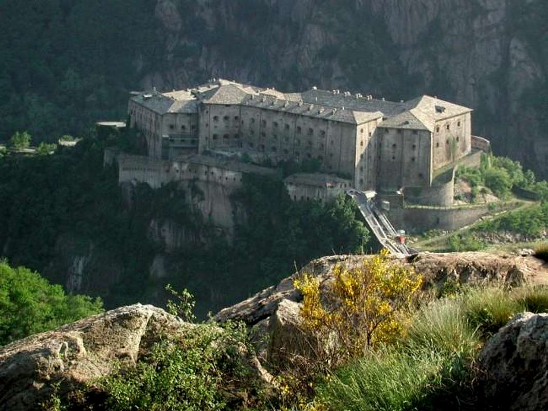
Bard continue Southwest towards the above and very long Champorcher Valley (
566m; Castle of X° Century; Constructions and Medieval Bridge). The first in the village center of what had been the Roman consular road and the second on the Baltea Stream. The Castle, built by Ottone Lord of Bard originary by the House of Lorraine (France), after several disputes between the descendants until 1214 became the exclusive property of Lord Hugh of Bard until the seizure by the Duke Amedeo IV° of Savoy in favor of the Savoy States; he was shot down in 1661 by Carlo Emanuele II° who built a strong defensive replaced by 1830-31 from the current
Fortress of Bard. The same was used by 400 Austro-Piedmontese soldiers to repel the Army of Napoleon Bonaparte, resisting from 19th May to 01th June 1800, giving with the honors of war. Crossing the bridge above the same Baltea, you reach the close of the Municipality of
Hône (
364m; Parish Church of San Giorgio with its little statue and icon of the XVIII° Century, Chapel of San Grato XVII°).
Going up the Valley of Champorcher you reach the Common of
Pont - Bozet or Pontboset (
775m, 5.5 Km. from Hône;
Parish Church of St. Grat before 1600, built in locality
Villa" and now completely restored; archway entrance Medieval;
"granges"and
"Rascards"; drinking fountains in stone; with
double-arched bridge over the Torrent Ayasse; in town Fabrique arose major foundry, known as the
"Factory of nails"; in the small town hall square is also the
Hostel "Lou Creton di lui" ("The Crest of the Wolf") now completely restored; Gom Chapel of 1727, into the country). Sited at the foot of the high cliffs of the Mont Charvatton and the slopes of the
"Ravine of Ratus". From the chief-town marked trail that is part of the
4 "Paths of the Horrid" crossing the four Municipalities of Pont-Bozet (
"Ravine Pavel"), Champorcher (
"Goille of Pourtset"), Fontainemore (
"Gouffre de Guillemore") and Hône (
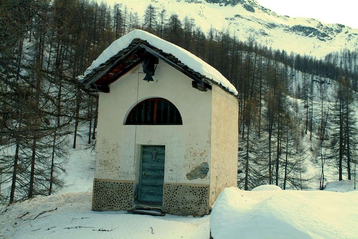
"Three Golilles de Hône"). Is what great gorgia excavated and carved by the great waterfall into a gorge above Brenve Creek and near the end of the Valley of Crest where the Shrine of
Re Tempio (King's Temple;
1470m). A hike that can be done using the path-mule track
n° 3/3C/Alta Via n° 4 to the Vallon of the Manda and then return to the village of Crest and, crossing to Brenve, reach the Sanctuary, or starting from Ravine and going from this last vallon (
EE; 2h'15/2h'45). A third way even longer part directly from Hône and passing near the Torrent Ayasse rejoins the previous Crest by just under one in the Alps Albarey and Frontiere. Continuing with the Regional road for Champorcher meet the Villages of Châtaigne, Piallemont, Trambesère, Savin, La Place (
1020m; octagonal Chapel with inscription about the plague of 1630), Salleret, Meller (1293 m) from where the path with
n° 13/14A can continue for the Oratory of Santa Anna
(1706m) at the Hill Finestra (
TE/F; 1h'15/1h'30. In addition you will reach the Capital of Château (
(1427 m; Squared Tower exclusive remain of an ancient
Castle of 1100 by Bard's Lords) and from this through the Royal Route Village Dondena
(2097m). From which with trail
n° 7B/7C/Alta Via n° 2 or, via the Refuge Dondena and path more in the South under the Mont de Dondena, with the
n° 7/Alta Via n° 4 to the
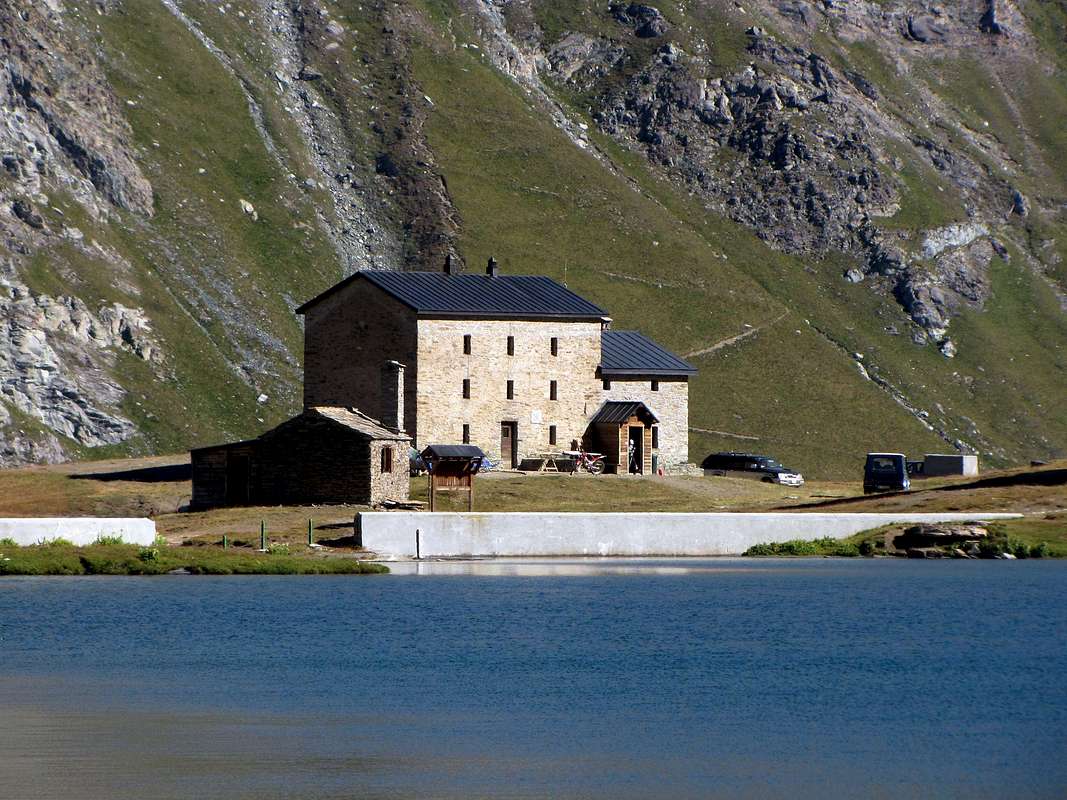
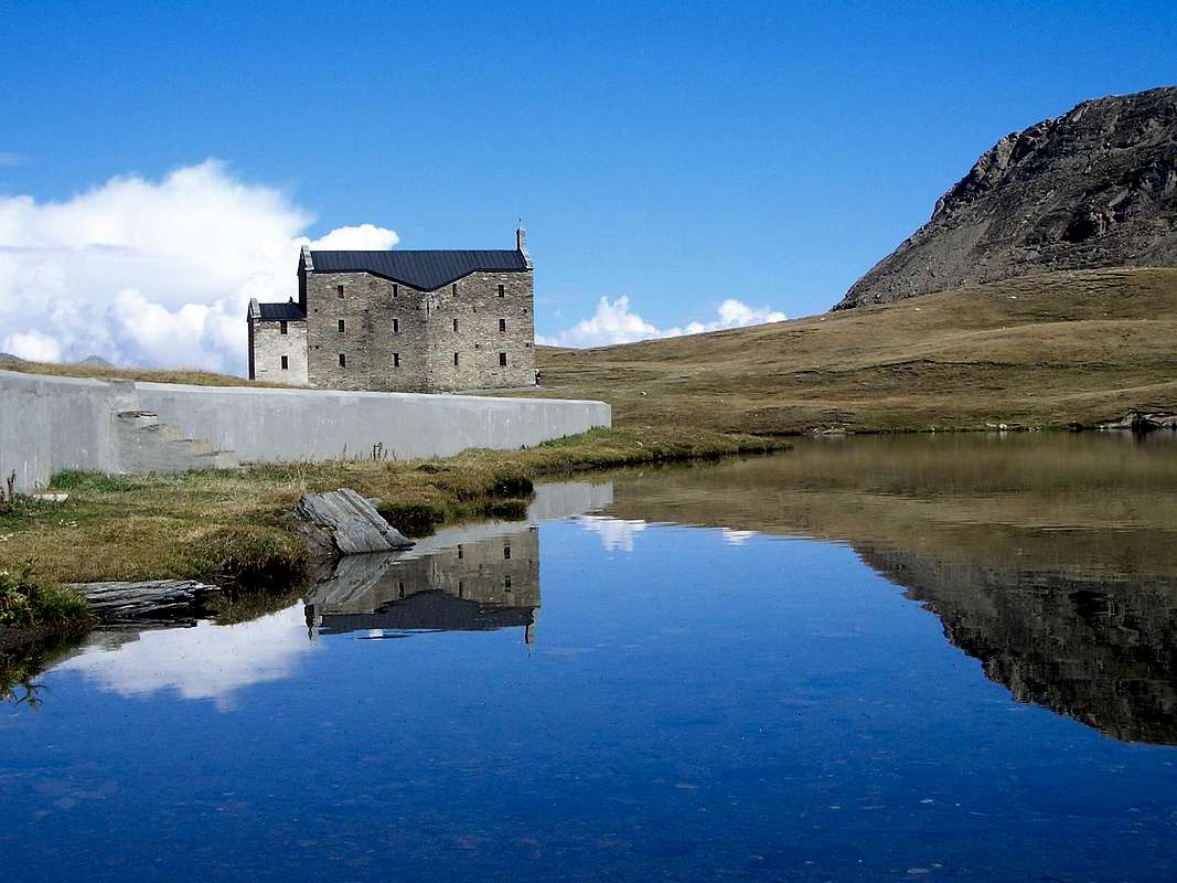
Miserin Sanctuary (
2582m; ancient Oratory became famous for the miracles that took place during the plague of 1630 and turned into
Chapel in 1658 by Pantaleone Savin; the same was damaged by heavy snowfall (11 metres of snow) the years 1714 and 15 for the which over the same thing in 1717 was built a small
Church with three altars. On August 5th, secular
Procession dedicated to "
Our Lady of the Snows". This, thanks to the construction of the Royal Road between Champorcher and Cogne, also attracted the inhabitants of the latter and of other valleys and the
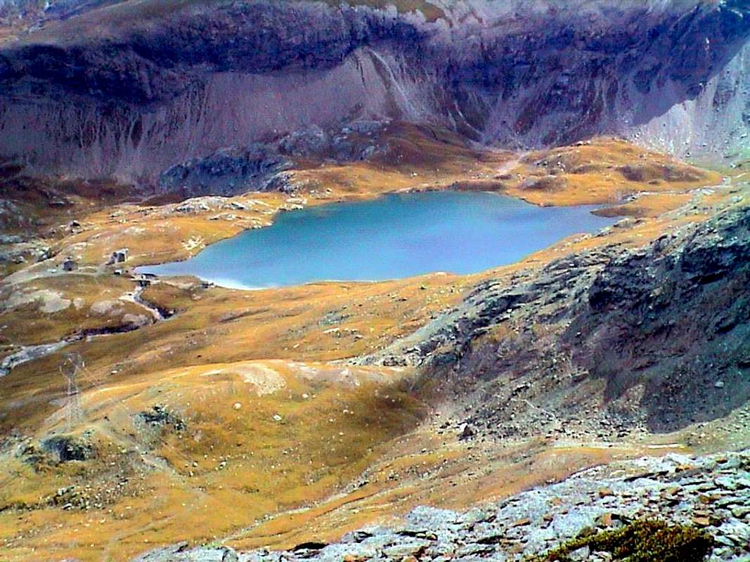
Sanctuary, more and more famous, was expanded in 1880 through the intervention of the famous Abbot Pierre Chanoux, Rector of the Hospice du Pt. St. Bernard, but a native of Champorcher; Don Filiberto Noussan, Pastor Champorcher, completed the work with the construction a second floor to allow the stay of more than 200 people, while the number of the procession have exceeded 5,000 units. Sanctuary is located on the North shore of Lake, that flaunts its very azure waters (
2588m;
TE/F; 1h'20 and with tour more in North nearby Mont Dondena
1h'40).
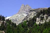
![]() Miserin Sanctuary between Punta Tersiva & Rosa dei Banchi,
Miserin Sanctuary between Punta Tersiva & Rosa dei Banchi,
by Antonio
Continuando ad Est ma poi abbandonando la Valle Centrale della Dora Baltea sul ponte sulla medesima, dal Comune di
Bard (
566 m; Castello del X° Secolo; costruzioni e Ponte Medioevali) con la Strada Regionale si prosegue verso Sudovest in direzione della lunga Valle di Champorcher. Tornando a Bard, da notare che le prime sono nel centro del paese su quella che era stata la strada consolare romana ed il secondo sulla Dora. Il Castello, costruito da Ottone di Bard del Casato francese dei Lorena, dopo varie contese tra i discendenti sino al 1214 diventò proprietà esclusiva di Ugo dei Bard insino alla confisca, dopo una lunga seie di litigi e contrasti famigliari, da parte del Duca Amedeo IV° di Savoia in favore degli Stati Sabaudi; nel 1661 venne abbattuto da Carlo Emanuele II° che ne costruì un forte difensivo, sostituito dal 1830-31 dall'attuale
Fortezza di Bard. La stessa servì a 400 soldati Austro-Piemontesi per respingere l'Armata di Napoleone Bonaparte, resistendo dal 19 Maggio al 1 Giugno 1800 e cedendo sol con l'onor dell'armi. Passando il ponte sulla Dora, si raggiunge il viciniore Comune di
Hône (
364 m; Chiesa Parrocchiale di San Giorgio e statua del medesimo con icona del XVIII° Secolo; Cappella di San Grato XVII°;). Risalendo la Valle di Champorcher, dopo una serie di ripidi tornanti atti a vincere il primo spalto, si raggiunge il Comune di
Pont - Bozet o Pontboset (
775 m, 5,5 Km. da Hône;
Chiesa Parrocchiale di San Grato nel centro detto Villa, anteriore al 1600;
voltone d'ingresso Medioevale; "granges", "rascards" e fontanelle in pietra; ponte con doppia arcata sul Torrente Ayasse; in località Fabrique sorse un'importante fonderia, detta la
"Fabbrica dei chiodi"; nella piccola piazza del Municipio si trova anche l'
Ostello "Lou Creton di Lui" ("La Cresta del Lupo") nell'edificio seicentesco che ospitava l'
antica Parrocchia, oggi completamente restaurato; famosa
Cappella del Gom 1727, proprio all'ingresso nel paese). Il caratteristico ed
"arcigno" Comune é sito ai piedi delle alte pareti rocciose del Mont Charvatton
(1787 m) ed alle pendici dell'
"Orrido del Ratus" all'interno del Torrent Ayasse. Dal capoluogo sentiero
segnalato che fà parte dei
4 "sentieri degli orridi" che attraversano i quattro comuni di Pont-Bozet (
"Orrido di Ratus"), Champorcher (
"Goille di Pourtset"), Fontainemore (
"Gouffre de Guillemore") e Hône (
"Tre Golilles de Hône"); risulta qual grande gorgia erosa ed escavata dal Torrente Brenve e quasi al termine del Vallone del Crest dove trovasi il
Santuario di Re Tempio (1470 m). Questa risulta qual bella escursione che si può effettuare tramite il sentiero-mulattiera
n° 3/3C/Alta Via n° 4 verso il Vallone della Manda per poi
"rientrare" ad Oriente verso il Villaggio del Crest ed, attraversando quello di Brenve, raggiungere il Santuario, oppure con partenza dall'Orrido e risalendo quest'ultimo vallone (
EE; 2h'15/2h'45). Una terza via ancora più lunga parte direttamente da Hône e passando accanto al Torrent Ayasse si ricongiunge alla precedente dal Crest appena sotto il medesimo presso le Alpi Albarey e Frontiere e sulla poderale. Continuando con la strada Regionale per Champorcher si incontrano le piccole Frazioni di Châtaigne, Piallemont, Trambesère, Savin, La Place (
1020 m; Cappella ottogonale con iscrizione al riguardo della peste del 1630), Salleret e
Meller (1293 m), da dove con sentiero
n° 13A/14A si può proseguire con bell'escursione, nei tempi andati oggetto pure di Processione, per l'
Oratorio di Santa Anna (1706 m) non lungi dal Colle Finestra (
TE/F; 1h'15/1h'30). Oltre si raggiunge il Capoluogo di Château (
(427 m; Torre Squadrata unico resto dell'antico
Castello del 1100 dei Signori di Bard, dato a fuoco nel 1212 da parte di incursione armata di Guglielmo di Pont Saint Martin, uno dei tre fratelli tra i quali era scoppiata la contesa) e da questo, tramite la Strada Reale fatta costruire da
"Re Toio" nel 1862, il Villaggio di Dondena
(2097 m), sottostante al Mont Glacier ed al Mont Delà
(3186 m, 3139 m). Donde, con sentiero
n° 7B/7C/Alta Via n° 2, oppure, passando per il
"Rifugio di Dondena"(2193 m) e con sentiero più a Mezzogiorno sotto il Mont de Dondena, con il
n° 7/Alta Via n° 4 al
Santuario del Miserin (
2582 m; antico Oratorio diventato rinomato per i miracoli avvenuti durante la peste del 1630 del e trasformato in
Cappella nel 1658 da parte di Pantaleone Savin; la stessa venne danneggiata dalle copiose nevicate (11 metri di neve) degli anni 1714 e 15 per la quale cosa nel 1717 sopra la medesima venne costruita una
Chiesetta con tre altari. Il 5 Agosto secolare
Processione dedicata alla
"Madonna delle Nevi". L'avvenimento, grazie alla costruzione della Strada Reale tra Champorcher e Cogne, attirò anche gli abitanti di quest'ultima e di altre vallate attigue ed il
Santuario, sempre più famoso, venne ampliato nel 1880 per intervento del famoso Abate Pierre Chanoux, Rettore dell'Ospizio del Piccolo San Bernardo ma nativo di Champorcher; Don Filiberto Noussan, Parroco di Champorcher, completò l'opera con la costruzione di un secondo piano tale da permettere il pernottamento di oltre 200 persone, mentre le presenze alla Processione hanno superato le 5.000 unità. Il Santuario é sito sulla sponda Settentrionale del Lago Miserin, che ostenta le sue acque azzurrissime, tra le più azzurre di tutti i Laghi della Val d'Aosta (
2588 m;
TE/F; 1h'20 e con più largo giro più a Settentrione verso il Rifugio di Dondena, il Mont de Dondena
(2543 m) ed il Mont Rasciàs
1h'40).
![]() Ancient Miserin Sanctuary nearby the homonym Lake,
Ancient Miserin Sanctuary nearby the homonym Lake,
by Gabriele Corvini aka Corvus