But also a trip to the "Christianity". Because by doing this tour, which is a variation as opposed to the one presented on the page A or
, in addition to the layman to encounter many of the same signals that testify of Evangelization took place in Aosta Valley since III° / IV° Century. In fact, after a portion, usually on the valley floor, marked by castles or simple Roman and Medieval vestiges alternating symbols of Christianity going up the hill we find more and more the passage of the latter typology while leaving to decay the first small villages or to pastures. Clear sign of how the
going up to the top, where you will need a life of sacrifices not to be well-off. A clear message as to the poor peasants were left him yearning for more
that no attractions and the riches of this life. Always, of course, at the cost of a hard and perpetual work into the fields, forests and with the livestock. For this reason, as we move away from the valley floor, marked by the course of Baltea, there are always small
. A stark reminder of how even the ancient
, here is sheltered dwelling and along the roads and trails of the hill. Or seeking shelter, abandoned down there their
of the Romans already from the third Century BC. That's why it deserves a visit the
trying to figure out what was their, rather than style, way of life or what was the best way to survive. To achieve this, we must, after traveling the State Road n° 26 from Aosta City towards Villeneuve Common along the streets
, and then exceeded Arvier and Liverogne and get off with a detour in North towards Dora Baltea. A bridge
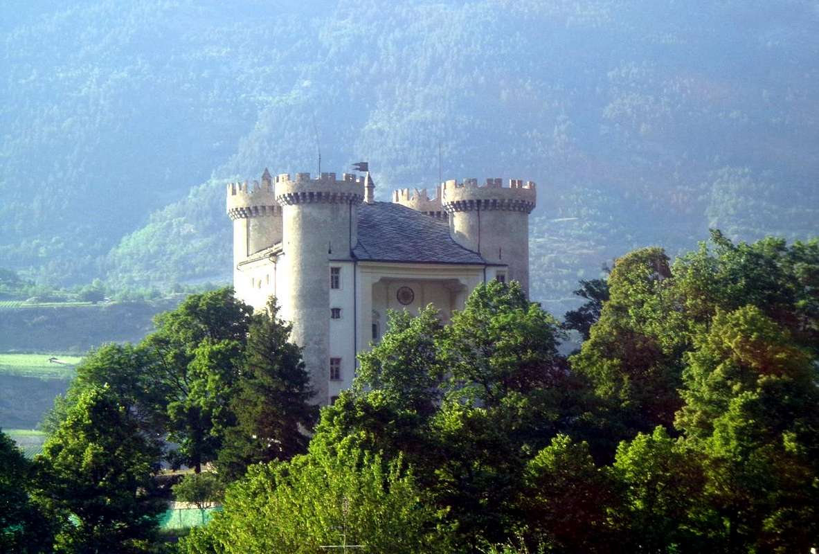
, designed to replace the medieval one below, leads us to Avise, where begins our specific journey. Entering the country ahead four surprises: a castle "supervised" by a high tower, a beautiful church and a bridge.
Ma un viaggio anche verso la "Cristianità". Perché effettuando questo tour, che é una variante al contrario di quello presentato nella pagina A o
, oltre al profano s'incontrano numerosi segnali della medesima che testimoniano dell'Evangelizzazione avvenuta in Valle di Aosta a partire dal III°/IV° Secolo. Infatti dopo una parte, in genere sul fondovalle, segnata da Castelli o semplici vestigia medioevali alternati da simboli della Cristianità salendo la collina troviamo sempre di più il passaggio di quest'ultima mentre decadono i primi lasciando spazio a piccoli villaggi od ad alpeggi. Chiaro segnale di come la
salendo verso l'alto, dove vien richiesta una vita più di sacrifici che non d'agiatezze. Un chiaro messaggio di come ai poveri contadini venisse lasciato maggiormente l'anelito per gli
che non l'attrazioni e le ricchezze di questa vita terrena. Sempre, logicamente, a prezzo di duro e perpetuo lavoro tra i campi, i boschi e con il bestiame. Per questo motivo man mano che ci allontaniamo dal fondovalle, segnato dal corso della Dora Baltea, troviamo sempre
. Un chiaro monito di come anche l'antico
, qui si riparava abitando e percorrendo le strade ed i sentieri della collina. Oppure cercando riparo, abbandonata là in fondo la loro
dei Romani già dal III° Secolo avanti Cristo. Ecco perché merita una visita all'
cercando di capire qual era il loro, più che stile, modo di vita o meglio qual fosse la maniera per sopravvivere. Per ottenere ciò, bisogna, dopo avere percorso la Strada Statale da Aosta verso Villeneuve lungo le vie dell'
, e superati i paesi di Arvier e Liverogne, scendere con deviazione a destra (Nord) verso la Dora Baltea. Un ponte alto
, atto a sostituire quello medioevale appena più dabbasso, ci conduce al Comune d'Avise, dove inizia il nostro specifico viaggio sù per la medio-alta collina nonché verso la
. Entrando in paese ci attendono quattro belle soprese: un castello
da un'alta torre, una bella Chiesa ed un ponte più sotto.
When you get to Avise we must go back in high. A steep and narrow road, first paved in stone and then in asphalt, rises up through the Northwest side of the
Castle of Avise and behind the
Church of "Sorrows" with Romanesque Steeple (immediately below down an ancient path
"dashed" by stone small walls
reported but not numbered reaching through a beautiful walk the Le Pont with ancient
Medieval Bridge; 0h'30 between descent and ascent) and with steep hairpin bends reaches, leaving Southeast the
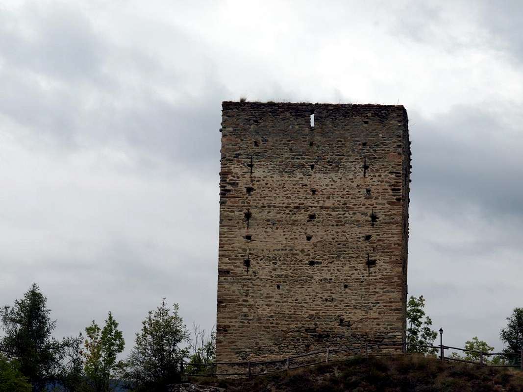
Church of San Brizio and the miserable ruins of the crumbling
Castle Bionay, the junction for Le Cré (
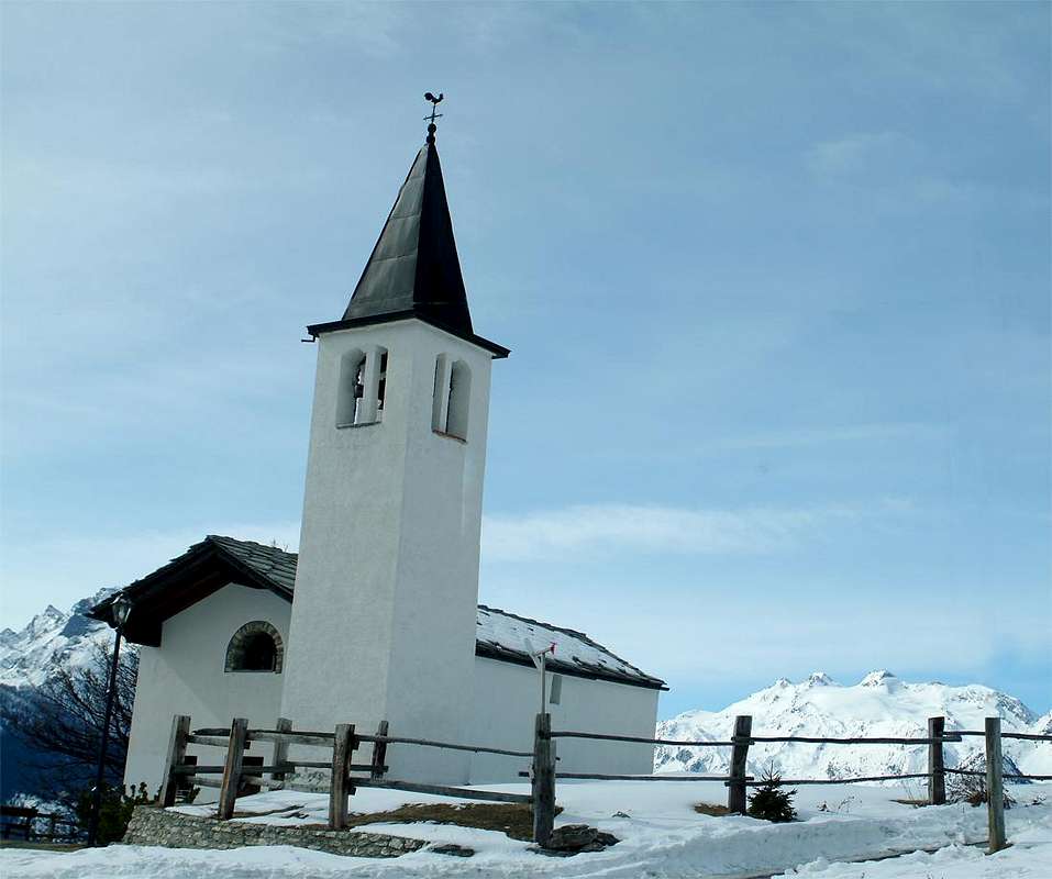
857m; votive Chapel) and then the Villages of Le Pré and Plan. A subsequent and long diagonal leads, through Tincon, the
"Picnic Area" Lo Crou
(1166m), suspended on a great precipice with facing the ridge from Monte Colombo dates back to the Mont Paramont. Here the same changes completely in East-northeast direction reaching the Village Cerellaz (
1254m; Saint Théodule Chapel) and adjacent to Cougnon (where comes the path
n° 18 starting from Le Cré-La Ravoire (
+ 893m; stroll with
three Crosses; 1h'00/1h'15). We are now completely on the most Western part of the
"Via dei Salassi" and all that remains is to continue Eastward. In a short time you reach in quaint Village of the Charbonniere (
1263m; Church of Saints Lorenzo Barbara), located under the
"Ru de Clavel" and where it comes, always from Avise-La Ravoire, the trail
n° 18A that goes up into the ravine between Avise and Fossaz (
1242m;
the same rise time). To make one of these excursions, however, it is necessary to organize the logistics by preceding a car nearby Cerellaz or Charbonnière, that then we can continue the way. To make one of these excursions, however, it is necessary to organize the logistics by preceding a car or Cerellaz Charbonnière, that then we can continue the way. Then continue Eastward to the junction
1278 metres, where the road splits sending a detour Northwest to the Village of Clavel (
1480m; Church of San Pantaleone), Cerlogne (
1480m; Church "Holy Trinity") and Vens (
750m; Church of Saints Leonardo and Bernard), before the Col de Mont Joux (
1930m; Church "Our Lady of the Snows") as well as the input of Vertosan Vallon. Do not follow this but the branch on the right until you reach the crossroads
1233 metres just after the Village of Fossaz (
1242m; Church of San Domenico) and the next Chaillod (
1218m; Church of San Rocco), now in the Municipality of Saint Nicolas that you let down. From this continue to Ravoise
(1321m), Persod (
1351m; Church of San Antonio) and Petit Sarriod
(1444m), from which it imposes two choices:
1)- go left reaching Grand Sarriod (+ 1445 m) reaching Gerbore in succession (
1633m; Church of St. Giacomo), Vétan Dessous (
1670/97m; Church of Saints Bernardo and Lorenzo) and Vetan Dessus
(1737/70m) from which you fall with the same road to Petit Sarriod. Or
2)- continue on this last until Meod Dèsott and Damon (
1498m, 1520m, Church of St. Bernard with the statue and dedication to the
"Fallen in the Mountain" with photographic panels). Even here there are two solutions:
3)- from Dèsott reach with a short walk and through the trail
n° 12A Vétan Dessous, otherwise
4)- Damon with a private road
not numbered, which reaches well around the same
(0h'35 for both). Now with a wide bend, they pass the two Torrents de Meod and de Verrogne reaching the village with this last name (
1595m; Church of San Teodulo) and at the foot of the eponymous vallon. Flexing in Southeast will reach the first Villages Homené Dessus and Dessous (
1493m, 1451m,, at the crossroads between the
Church of Santa Margherita, small walk with
"poderale unnumbered (0h'15), to above of Combelin
(1586m) at the foot of Becca France) and then continuing more Eastward to Bellun (
1382m; Church of Saints James and Margaret; "Hôtel des Salasses"). We are now in the most known and visited the
"Via dei Salassi", who enters the Vallon of Clusellaz the slopes of Mont Fallère but most of
Becca France (2343m) the slope of which
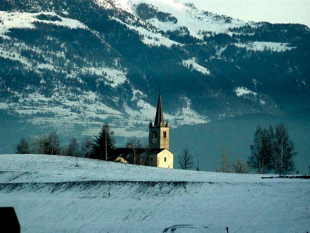
5 July 1564 "swallowed" the Village of Thôra with all of its 600 inhabitants. All that remains, leaving top New Thouraz from which you can still see the remains of the huge landslide, down to Ville sur Sarre (
1212m; Church of San Pantaleone) whence it imposes a final two choices:
5)- continue the same direction and, passing the Villages of Mondache, Conclonaz Lin Noir and Blanc, Arpuilles (
1040m; Church of Santa Barbara) and Excenex (
1046m; Church of St. Nicholas), reaching the Common of Gignod (
1075m; Church of St. Hilary, Château and Tour of Gignod) now at the entrance of the Valley of the Gran San Bernardo and
"buckling" to the
"Via Francigena" to the same. Or
6)- down towards Sarre not forget to check out the
Church of San Pietro dedicated to "Our Lady of the Angels" of 1737 in the locality Vareille
(1062m) or at Aosta through Pléod, Oveillan, Moron (
Church of St. Bernard) and Pont d'Avisod
(658m) small Hamlets, on the border with the City.
![]() "Going down to Gignod Common near the Via Francigena,
"Going down to Gignod Common near the Via Francigena,
by Osw
Giunti ad Avise bisogna risalire. Una stretta e ripida strada, dapprima lastricata in pietra e poi asfaltata, si innalza verso Nordovest passando a fianco del
Castello di Avise e dietro la
Chiesa della "Addolorata" con Campanile romanico (subito appresso scende,
"tratteggiato" con muriccioli in pietra, un antico sentiero
segnalato ma non numerato che, con bella passeggiata, raggiunge la località Le Pont con antico
Ponte Medievale; 0h'30 tra discesa e risalita) e con ripidi tornanti a gomito raggiunge, lasciando a Sudest la
Chiesetta di San Brizio ed i miseri ruderi pericolanti del
Castello di Bionay, il bivio per Le Cré (
857 m; Cappella votiva) e poi i Villaggi di Le Pré e Plan. Un successivo e lungo diagonale conduce, passando per Tincon, alla
"Area Picnic" di Lo Crou
(1166 m), sospesa su di un grande precipizio con di fronte la cresta che dal Monte Colombo risale verso il Mont Paramont. Qui la stessa cambia completamente direzione in Est-nordest raggiungendo il Villaggio di Cerellaz (
1254 m; Cappella di San Teodulo) e lo attiguo di Cougnon (dove arriva anche il sentiero
n° 18 partendo da Le Cré-La Ravoire (+
893m bella passeggiata con
tre Croci; 1h'00/1h'15). Siamo ormai completamente sulla parte più Occidentale della
"Via dei Salassi" e non rimane che continuare verso Oriente. In breve tempo si raggiunge il pittoresco Villaggio di Charbonnière (
1263 m; Chiesa dei Santi Lorenzo e Barbara), sito sotto il <i<
"Ru de Clavel"</i< e dove giunge, sempre da Avise-La Ravoire, il sentiero
n° 18A che percorre la gola tra Avise e Fossaz (
1242 m;
stesso tempo di salita). Per effettuare una di queste due escursioni é però necessario organizzare la parte logistica facendo precedere un auto per Cerellaz o Charbonnière, tale poi da poter continuare il percorso. Quindi proseguire verso Est fino al bivio
1278 metri, dove la strada si sdoppia inviando una deviazione a Nordovest verso i Villaggio di Clavel (
1480 m; Chiesa di San Pantaleone), Cerlogne (
1480 m; Chiesa "della Santa Trinità") e Vens (
1750 m; Chiesa dei Santi Leonardo e Bernardo), prima de Col del Mont Joux
1930 m; Chiesa "Madonna delle Nevi") nonché allo ingresso del Vallone di Vertosan. Non seguire questa bensì continuare sul ramo di destra fino a raggiungere il bivio
1233 metri subito dopo il Villaggio di Fossaz (
1242 m; Chiesa di San Domenico) ed il successivo di Chaillod (
1218 m; Chiesa di San Rocco), ormai nel Comune di Saint Nicolas che si lascia in basso. Da questo continuare verso Ravoise
(1321 m), Persod (
1351 m; Chiesa di San Antonio) e Petit Sarriod
(1444 m), donde si impone una duplice scelta:
1)- proseguire verso sinistra raggiungendo Grand Sarriod
(+ 1445 m) raggiungendo in successione Gerbore (
1633 m; Chiesa di San Giacomo), Vetan Dessous (
1670/97 m; Chiesa dei S.S. Bernardo e Lorenzo) e Vétan Dessus
(1737/70 m) dal quale si rientra con la stessa strada al Petit Sarriod. Oppure
2)- continuare da questo ultimo fino a Meod Dèsott e Damon (
1498 m, 1520 m; Chiesa di San Bernardo con statua e dedica ai
"Caduti della Montagna" con pannelli fotografici). Anche qui si presentano due soluzioni:
3)- da Dèsott raggiungere con una breve passeggiata e tramite il sentiero
n° 12A Vétan Dessous, altrimenti
4)- da Damon con una poderale
non numerata, che con largo giro raggiunge il medesimo (
0h'35 per entrambi). Ora con un'ampia ansa si oltrepassano i due Torrents de Mèod e de Verrogne raggiungendo il villaggio con questo ultimo nome (
1595 m; Chiesa di San Teodulo) ed ai piedi dello omonimo vallone. Flettendo a Sudest si perviene dapprima ai Villaggi di Homené Dessus e Dessous (
1493 m, 1451 m; al bivio tra i due
Chiesa di Santa Margherita; piccola passeggiata con poderale
non numerata (0h'15), al soprastante di Combelin
1586 m ai piedi della Becca France) e poi procedendo più verso Est quello di Bellun (
1382 m; Chiesa dei Santi Giacomo e Margherita; "Hôtel des Salasses"). Ormai siamo nella parte più conosciuta e frequentata della
"Via dei Salassi", che entra nel Vallone di Clusellaz alle pendici del Mont Fallère ma soprattutto della
Becca France (2343 m) il versante della quale il
5 Luglio 1564 "inghiottì" il Villaggio di Thôra con tutti i suoi 600 abitanti. Non rimane che, lasciando in alto la Nuova Thouraz dalla quale si possono ancora osservare i resti della colossale frana, scendere a Ville sur Sarre (
1212 m; Chiesa di San Pantaleone) donde si impone un'ultima duplice scelta:
5)- proseguire con l'identica direzione e, passando i Villaggi di Mondache, Conclonaz, Lin Noir e Blanc, Arpuilles (
1040 m; Chiesa di Santa Barbara) ed Excenex (
1046 m; Chiesa di San Nicola), raggiungere il Comune di Gignod (
1075 m; Chiesa di Santo Ilario; Tour e Château di Gignod) ormai allo ingresso della Valle del Gran San Bernardo ed
"allacciandosi" alla
"Via Francigena" verso la medesima. Oppure
6)- scendere verso Sarre senza dimenticare di dare un'occhiata alla
Chiesetta di "San Pietro Madonna degli Angeli" del 1737 in località Vareille
(1062 m) o ad Aosta passando per i Villaggetti di Pleod, Oveillan, Moron (
Chiesa di San Bernardo) e Pont d'Avisod
(658 m), giusto al confine con la Città.
"Chapels, Churches & Bell Towers from Avise-Cerellaz towards Gignod or Aosta in the more Eastern Salassian Route ..."
by Osw 2015