
|
|
Route |
|---|---|
|
|
Hiking, Mountaineering |
|
|
Overview
Penine Way is one of the long distance routes in the UK. What I have chosen was the Peak District part of the Penine Way going across almost entire Peak District.
Marsden to Edale part of the Penine Way is a classic walk, often called Dark Peak challenge.
When I was looking online for some descriptions of the route I found some descriptions which measure this route to be 35km long. How they got that no idea... My GPS measured the distance to be 43km. I was also wondering how can anyone do Marsden to Edale in one day as many people describe... unless they run the whole route...
And the route is quite a challenge... I don't mean difficulty because if the terrain. No, the terrain is mostly flat. It's the distance.
Here are my times for the route (including short breaks):
- Day 1: Marsden - Snake Pass 10h 40min
- Day 2: Snake Pass - Edale 6h
Getting There
A good starting point is Marsden, where you can arrive by train. Arriving by train would be best since the route goes southwards and doesn't return to Marsden so it would be more difficult with a car.
My adventure started with another "adventure". My train into Manchester was late (as they almost always are) and then the train from Manchester to Marsden was cancelled... and I had to wait for an hour for the next one. Unfortunately, as I was told by people who run buses, there is no bus from Manchester centre to Marsden so my only choice was to wait for an hour.
Route Description
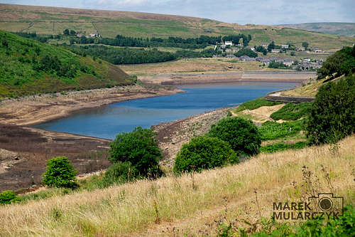
Exit the train station and walk down the road towards town centre following Station road. Follow the road straight down the hill and under the bridge. And continue walking almost straight until you get to the Butterly Reservoir.
The path runs along the reservoir. Here's the photo of the reservoir:
A word of warning (unless you're used to it) - there are hardly any signs on the route! If I didn't have GPS I would have lost the route many times as there were no signs at all almost entire time... The two photos I took of the signposts with Penine Way on them were the only ones I saw in two days...
And there are no colour-coded routes like we're so used to everywhere in Europe. It's just a path...
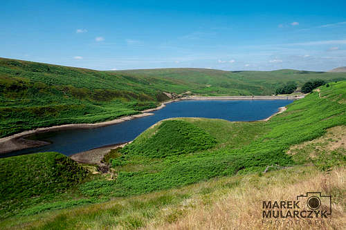
When you get to the reservoir the path will lead you along Butterley Reservoir and then Blakeley Reservoir and Wessenden Reservoir and Wessended Head Reservoir... until after about 2 hours after starting from Marsden rail station you get to the first road of the day - A635 by Wessenden Head.
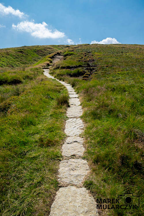
After crossing the road (it's just a road with some parking) head on and start ascending towards Black Hill (582m) - first "serious" mountain in your trip.
Path leading towards Black Hill can't be missed as it's paved with stones:
Once you've reached Black Hill (nothing special here, it's just a hill, it's even hard to tell where the actual peak is) you start slowly moving towards Torside Reservoir. And it's actually quite nice walk (still no trees unfortunately).
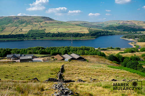
Once you get to Crowden the path goes across the street and finally for a little bit (and that's the only section on day 1) into a small forest. The path runs along Torside Reservoir and then crosses it to the other side and then starts going up.
You're now 3 and a half hours from Marsden rail station.
Here's a view of the Torside Reservoir from halfway through the ascend towards Bleaklow Head.
From here on, the path gets narrower and less obvious most of the way to Snake Pass.
Here's a photo that shows what the path looks like. It's very narrow in places and there was no water to be seen (it may be just a dry season but keep that in mind).
Somewhere on the route below the summit of Bleaklow I found a small stream with some water. On the map it's marked as Wildboar Grain and it's close to Bleaklow as you head south.
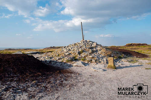
Then there's Bleaklow Head itself:
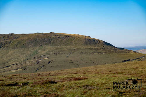
From Bleaklow the descend towards Snake Pass starts. At Snake Pass there is some parking space again. I just crossed it and kept walking, this time towards High Peak which you can clearly see in front of yourself:
The path initially runs on a flat land, for about 30-40min and then ascends the hill you can see on the picture above from the right hand side. You're getting on Mill Hill and from here you start walking along the ridge of Kinder Scout, first to Kinder Downfall which seems to take forever.
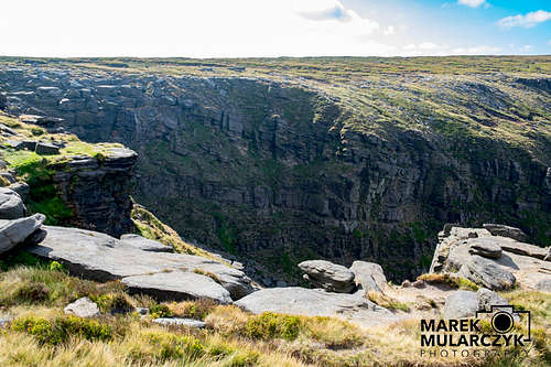
Finally, when you get to Kinder Downfall, you realise that the trail turns sharp right and goes almost in the same direction(!) just slightly more south (the hill you can see in the background of the photo above shows the hill which you will need to follow, the entire hill) and this takes you to Kinder Scout. There are lots of rocks on Kinder Scout so the landscape is a bit more interesting, however, as you can see form the photos, still no sign of any trees.
In the corner, where you 're turning right to walk towards Kinder Scout, there is a beautiful gorge:
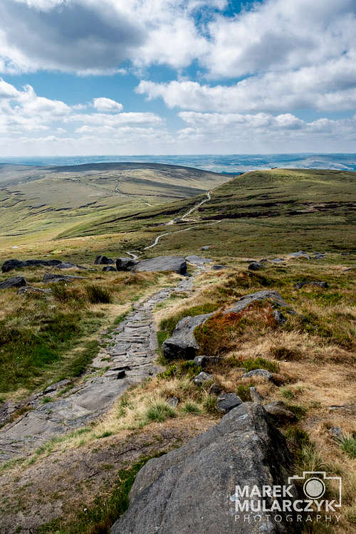
Here's the path from Kinder Scout towards Edale - a final part of the Penine Way:
As you approach the vale of Edale, the trail leads into a path called "Jacob's Ladder", a very interesting section of the trail.
Once you go down through Jacob's Ladder you're in Edale Valley. At the bottom of Jacob's Ladder there's a stream (you'll be walking across it through a bridge) where you can fill up a bottle with water as there will be no water on the trail any more (and this was the only place I found where there was water on day two, between Snake Pass and Edale).
From Jacob's Ladder it's about an hour to Edale rail station.
Essential Gear
It's an easy route so no climbing gear required. Just good mountain boots.
External Links
http://mar-travel.com/mountains_uk_peakDistrict_PenineWay.html