Overview
![Sasso Canale south face]() Sasso Canale and Sasso Campedello Sasso Canale and Sasso Campedello |
The area around
Lago di Como and
Valchiavennais famous for its elevation differences. While the valley floors and lake shores measure little more than 200m the first mountains, about 3km to the sides of the valleys measure already around 2000m, making them all fantastic lookout-peaks with jaw-dropping views. To the north of
Lago di Como, west of the smaller
Lago di Mezzola one of these mountain ridges starts, with its first culmination point
Monte Berlinghera (1930m), then heading onwards to
Sasso Canale (2411m),
Sasso Campedello (2310m)),
Pizzo Anna Marie (2397m),
Motto Rotondo (2452m) and
Pizzo Cavreggasco (2535m).
Of these,
Sasso Canale and
Sasso Campedello are the most prominent, as the tower above
Valchiavenna and are visible from anywhere on the valley floor. The huge elevation difference requires a trailhead halfway up the mountain, which can be found at
San Bartolomeo, a hamlet high above
Lago di Como. The first part of the route is actually quite popular as it also serves
Monte Berlighera the sentinel mountain at the end of the ridge.
Sasso Canale is a flat topped mountain with a broad summit plateau, which drops of steeply towards
Valchiavenna. The far side, which is far less steep, however, is hard to reach so that the normal route cuts right through the vertical south face to climb a brittle gully towards a saddle on the summit ridge.
Much of the lower sections of the route to
Sasso Canale runs along the south-east ridge directly, offering wonderful views across and down the valley. During our visit, however, a strong storm blasted the area so that we were forced to stay beneath the lee side of the ridge and even had to abandon the final summit push for the last 150m. Instead we opted for
Monte Berlinghera upon returning.
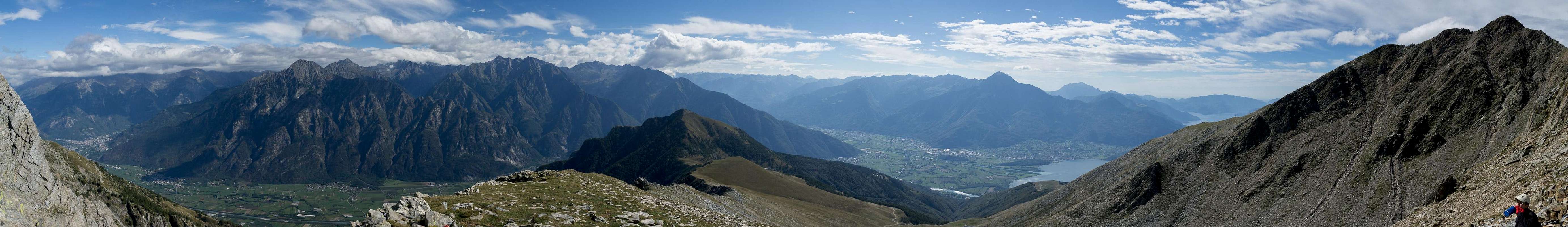
Panorama
180° panorama from our highpoint 150m beneath Sasso Canale |
Getting There
![La Corvegia (2282m), Sasso Canale (2411m), Sasso Campedello (2310m)]() La Corvegia (2282m), Sasso Canale (2411m), Sasso Campedello (2310m)
La Corvegia (2282m), Sasso Canale (2411m), Sasso Campedello (2310m)
The closest trailhead for
Monte Berlinghera and
Sasso Canale is at the little mountain hamlet
San Bartolomeo hogh above
Lago di Como.
- From the south (Milano)
Two options:
-
- Take motorway A9 north to Como
- Switch to SS340 to Menaggio
- Head straight on northwards alon SS340dir to Gera
- Leave onto a side road to and through Bugiallo until you reach the end of the road at the chapel San Bartolomeo
- Take SS36 north to the end of Lago di Como
- At Pontaccio leave onto SS340dir north-west to Poncetta, Sorico and Gera
- Take the same mountain road through Bugiallo to San Bartolomeo
- From the north (Splügen, Switzerland)
- Take motorway A13 to Splügen
- Leave the motorway at Splügen for Splügenpass
- At the border the road switches to SS36, which you follow through Chiavenna
- At Nuova Olonio leave to the south-west in direction Poncetta
- Take SS340dir to Gera
- Take the mountain road through Bugallio to San Bartolomeo
- From the east (St Moritz, Maloja, Switzerland)
- Take B27 / B3 across Malojapass into Bergell / Val Bregaglia
- At the border it turns into SS37 to Chiavenna
- Switch to SS36 south to Nuova Olonio
- Leave SS36 to the south-west in direction Poncetta
- Take SS340dir to Gera
- Take the mountain road through Bugallio to San Bartolomeo
Route
![Sasso Canale]() Sasso Canale seen from Monte Lago
Sasso Canale seen from Monte Lago
From
San Bartolomeo (1204m) a narrow hiking trail leads through dense forest northwards cutting short a large bend in a dirt road, which heads for the twin alp hamlets,
Alpe Pescedo and
Alpe di Mezzo. Hike through
Alpe di Mezzo and up a broad valley, which leads to the
Sasso Canale south-east ridge.
Follow the ridge on the southern side until you reach a saddle at approximately 2200m. Here the path switches to the north-east side of the ridge heading for the south face of the summit block directly. A bit of scrambling takes you to a saddle in the middle of the summit ridge from where you easily reach the summit plateau of
Sasso CanaleRed Tape
There's no red tape here. On the lower stretches of the route you pass among private property (fences) so stay on the path.
When to Climb
Best climbed in summer and autumn. Up to 2200m the route is safe for snowshoeing or tour skiing in winter. The Sasso Canale south face, however is dangerous during avalanche season.
Accommodation
There's lots of accomodation options around Lago di Como, including hotels, apartments, agriturismo and campgrounds. There are numerous sites in at least three different languages. A good starting point should be
Weather Conditions
Maps & Books
Maps
- Digital Maps
- Regular Maps
- Valchiavenna, Val Bregaglia
Kompass Map WK92
Kompass Verlag
1:500000
ISBN: 978-3-85026-694-9
Books
- Comer See
Eugen E. Hüsler
Rother Verlag
ISBN: 978-3-7633-4040-8

 3573 Hits
 80.49% Score
 12 Votes
 Sasso Canale and Sasso Campedello


 La Corvegia (2282m), Sasso Canale (2411m), Sasso Campedello (2310m)
 Sasso Canale seen from Monte Lago