
-
 5255 Hits
-
 72.08% Score
-
 2 Votes
|
|
Mountain/Rock |
|---|---|
|
|
37.58173°N / 25.22618°E |
|
|
Download GPX » View Route on Map |
|
|
Cyclades (Tinos) |
|
|
Hiking, Mountaineering, Scrambling |
|
|
Spring, Summer, Fall, Winter |
|
|
2392 ft / 729 m |
|
|
Overview
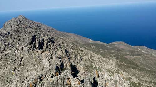
Tsiknias (729m) [“Τσικνιας”] is the highest peak on the island of Tinos (“Τηνος”), rising to its impressive height right out of the Aegean Sea on the Northeast edge of the island, a region battered by the Northern winds of the Ikarian Straight. The mountain is steep and rocky, beginning from the sea and rising via a ridge up until the summit, where it gives way to steep slopes. According to Homer it was also called “Gyras” or “Gyros”, after the Gyraians, one of the tribes who had settled on the island.
The mountain is dominated by shrubbery and is characteristically lush. During ancient times the plateau and valleys around Tsiknias were filled with cedar trees, however, due to their quality few remain today. The mountain plays a key role in the local environment by increasing rainfall and thus vegetation but also by being home to 19 species of birds.
History & Area Guide

|

|
|
As the tallest summit on the island, it has played a key role in the lives of residents throughout history. Tsiknias is well documented in Greek mythological tradition, with multiple stories mentioning it, primarily associating it with the god of wind “Anemos”, (“Άνεμος”) due its location at the direction of the powerful Northern winds.
In Homer’s Illyad it is suggested that Ajax the Great (“Αίας”) and his crew washed up on the shores below it via the intervention of Poseidon who sought to save them from the wrath of Athena. Upon landing ashore Ajax’s crewmates were quick to praise the gods while he did not. Then out of rage Poseidon sank the part of the island they were on. Homer provides a description of the mountain, which extended further into the sea, forming either a crescent or an arch; this feature is not there today.
Across from the summit to the West, at the middle of the plateau, lies the post-roman fort of Exomvourgo (641m) [“Εξομβουργο”], which is located atop a similar rock formation to those in Meteora. It was the capital of the island since Byzantine times but was mainly ruled by Venetians from 1207, being named “Castello di Santa Elena”, it would remain under their control until 1715 when it was conceded to the Ottomans, who then dismantled it in about 3 days. In the 17th century the castle had approx. 1,500 residents, 677 homes and 5 churches. Today little remains.
Further Northwest from the summit lies the village of Volax (“Βολαξ”), which is home to scattered volcanic granite rocks which create a “moon-like” ambiance in the area. It is unclear how these rocks got here considering that Tinos has no confirmed volcanic record. The name of the village originates from the Latin “Vulacus” i.e. (the) place with rocks. Within the village the Valier crest can be seen; a lineage which gave Venice two Doges. The village is a popular destination for bouldering.
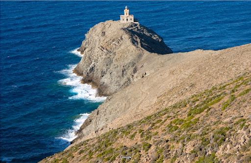
Right under the mountain on its Northern flank, the Magganari (“Μαγγαναρι”) ravine leads to the sea; it is an unusually lush ravine for a Cycladic island, all due to Tsiknias. The ravine and its river meet the sea at the beach of Livada (“Λειβαδα”), a north facing rock beach which is home to geese, goats, and a plethora of other animals. Finally, on the Northmost tip of the island, below the ridge of Tsiknias, is the lighthouse of Papargyros (Livada), at the edge of the Cyclades, it can be accessed via a short hike. There are all connected via marked trail M3 - "Nature in Antithesis", maintained by Tinos Trails.
Getting There
Getting to Tinos from Athens
To get to the island of Tinos from Athens a ferry must be taken either from the port of Rafina or Piraeus which can take between 2.5 to 4 hours. It is possible to bring a vehicle, including RVs.
Getting to the Trailhead
The main trailhead is located on the main road under the mountain outside the village of Steni (“Στενή”). It can be accessed by car, taxi hire, or bus (and a walk). The trailhead is at approx. 350m for a gain of 427m. Coordinates: (37.590232, 25.223090)
There is a local bus (KTEL) which operates from the port of Tinos and other villages to Steni, from there it is a less than 30 minutes to the trailhead. Learn more about the bus schedule on the KTEL Tinou website.
By Plane via Mykonos
The closest international airport is located on the island of Mykonos. From Mykonos it is about 20-45 minutes by ferry to the port of Tinos.
Route(s)
Please be mindful of snakes. Tinos is home to Vipers and other venomous snakes.
Standard Route (Profitis Ilias)
- Distance: 1km (top section only)
- Duration: 35 mins (top section only)
- Elevation Gain: 550m (179m top section only)
- Difficulty: Easy
- Water: None
From the trailhead the move towards the mountain and up its flank on the West face up to 550m where the chapel of Profitis Ilias (“Προφήτης Ηλίας”) is located. The trail is well marked but steep. The chapel can also be accessed by 4x4 – the road takes you through and above an old mine. From the chapel there is less than 200m elevation difference over 1km, the first 250m are crossing the chapel plateau going Northeast. From there the trail gets steeper and more exposed, moving along the ridge for about 500m. The final 250m are less exposed but steeper as the trail turns North and “climbs” the South face for the final 50m of delta.
Visit & Open New Ones!
Tsiknias is a challenging mountain and only the standard trail in maintained and known about. Its ridge has a number of caves and there are plenty of chimneys and other climbing features. If this article piqued your interest, then make the trip and open a new route. Looking forward to reading about it!
Due to elevation, location, and snakes, it is not recommended to hike on the mountain after late May. The best seasons for hiking the mountain are spring and autumn – late spring and late autumn both have stable weather. It is best to avoid high winds and rainfall. The mountain is known to occasionally receive snow (once a decade or so).
In spring the weather tends to get stormy on the mountain in the afternoon.
In summer the island is a popular (and expensive) destination.
Huts & Camping
Camping is permitted although not recommended due to the prevalence of snakes, the high winds, and lack of water. If you do want to (or need to) stay the night, the grounds of the chapel of Profitis Ilias offer some protection from the elements.
There are no huts on the mountain.
Natura 2000
Tsiknias and Northern Tinos including the valleys of Volax are part of the Natura 2000 network, specifically for the protection of birds, a total of 19 species have been noted in the area. This includes small fowl like Turtle Doves (classified as vulnerable) and larger birds like Grey Heron and Little Egret. The waters and vegetation of the island play a crucial role in the migration of birds across the Mediterranean.
Summit Parnorama
External Links
Exilzes, "At the summit of Tsiknias", Youtube video, 2021.
"The history of Tsiknias: Truths and Myths, of Yesterday and Today", Tinos.biz, 2008, blog.
WikiLoc, At the top of Tsiknias, 2016.
Exomvourgo Peakbagger page.
Tsiknias Peakbagger page.
Tsiknias and Northern Tinos Natura 2000, website.
TheCrag, Volax, website.
Village of Volax, website.
Trail M3 - "Nature in Antithesis", Tinos Trail, website.
Tinos Trail website
KTEL Tinou website.
Tinos Hiking Map 1:26k, Anavasi, ISBN: 978-960-8195-998.