Grey OVERVIEW Grisenze
All pictures of this page are by Antonio Giani, livioz, marco979, SalVal & Osw.
Valgrisenche long over 25 Km until the borders with Valdisère, wide from 3 to 10 Km, is even known and called as "Grey" Valley.
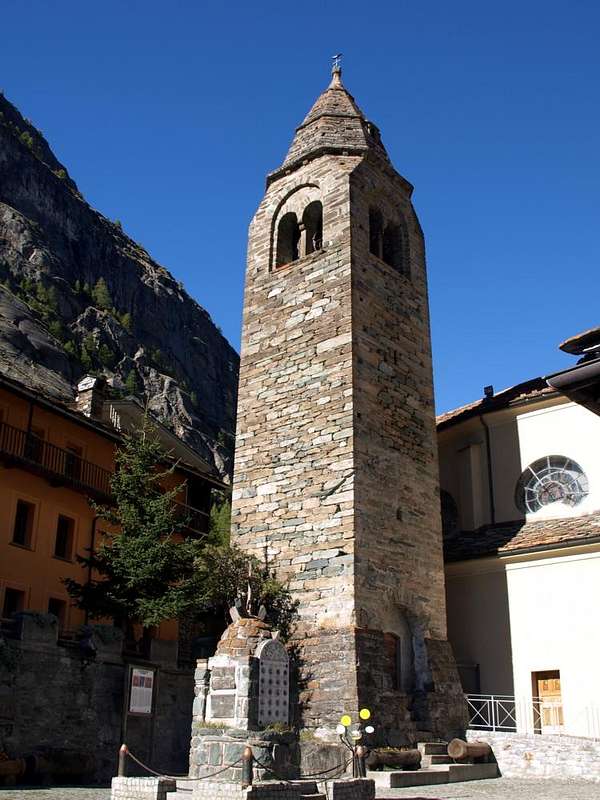
Perhaps to emphasize the always cool or cold temperatures fueled by the winds that come from the magnificent Great Sassière (3751m), maximum peak of this long and lonely valley, but also the highest elevation between the Gran Paradiso (4061m) and the Group of Mount Blanc (4810m), with the Aiguille des Glaciers (3817m), but in fact it is also and above all a green valley, where this color abounds everywhere from the grasslands of the plains to the edge of the its glaciers. Takes origin from valley floor nearby the little Hamlet of Leverogne or Liverogne (L'Eyvies or Waters "mangy", that impetuous) South of Dora Baltea Stream and salt winning one bastion below the Tower of Montmayeur or Mont Majeur, also known as the Tower of Arboé or Haury and yet told of Anry, famous for its terrible and horrifying legends (from the rock were thrown the hated enemies or sentenced horrid below), then, before, the valley is wedged in the course of the homonymous Dora and, after, progressively opening in a plain, which starts offering views of the entire and semi complete Group of Testa (Head) del Rutor (3486m).
Leaving on the right (West) on the great Vallon of Planaval-Fond continues more open and, after several villages, reaches Valgrisenche, its Chief Town at the foot of the Dam Beauregard, being closed to the danger due to landslides on its slopes. Remains of its waters still bury the old Village Fornet, once the center of life fruitful and where bread was cooked twice in each year; the new Fornet (1726m) was then built just upstream the tributary of artificial lake. Two side streets surround it: the first fraction from the salt on his Eastern side of Mondanges Fraction is currently closed to traffic for these reasons. The second runs along the opposite side to reach the small Villages of Bonne and Menthieu and then dropped to Surrier and Us(s)ellières Pastures, where he started on the path to Mario Bezzi Shelter at Vaudet Alp (2284m), located at the Northern foot of the wide Glacier of Glairetta or Gliairetta. Hence descends linearly up to the Planaval Fraction (1557m) (now in Arvier Commune) with its 13th century castle where it is "married" with the Torrent de Fond coming from the homonymous lake (2439m) at the foot of the North-east glaciers of Rutor and at the large Eastern Wall of Mont Paramont (3300m).
Above reigns Great Sassière. They say that this is the most panoramic of the Valley and that from its top you can see over 1000 mountains and 230 glaciers.
La Valgrisenche lunga oltre 25 Km fino ai confini con la Valdisère in Francia e larga da 3 a 10 nel suo punto massimo è anche riconosciuta quale la Valle "Grigia".Forse a sottolineare le temperature sempre fresche o fredde alimentate dai venti che provengono
"spifferando" dalla Grande Sassière
(3751 m), massima vetta della valle, ma anche maggior elevazione tra il Gran Paradiso
(4061 m) e l'inizio del Gruppo del Monte Bianco
(4810 m) con l'Aiguille des Glaciers
(3817 m). In realtà appare anche e soprattutto siccome una valle verde, dove questo colore ovunque abbonda dalle praterie della piana insino ai margini dei suoi ghiacciai. Prende origine dal fondovalle nei pressi del Borgo di Leverogne o Liverogne (L'Eyvies od appunto Acque
"rognose", cioé impetuose) a Sud del corso della Dora Baltea e sale vincendo uno spalto sottostante la Torre di Montmay(j)eur o Mont Mayeur, detta anche Torre di Arboé o di Haury ed ancor d'Anry, famosa per le sue raccappriccianti leggende (raccontan che dalla rupe venivano gettati gli odiati nemici od i condannati nell'orrido sottostante). Quindi la valle dapprima s'incunea presso il corso dell'omonima Dora ed indi va progressivamente dischiudendosi in una piana, che inizia ad offrire viste sul
Gruppo del Rutor (3486 m). Lasciato sulla destra (Ovest) il grande Vallone di Planaval-Fond, prosegue più aperta e, superati diversi villaggetti, raggiunge Valgrisenche, suo capolugo ai piedi della Diga Artificiale di Beauregard, in fase di chiusura per la pericolosità dovuta a franamenti sui suoi versanti. I resti delle sue acque seppelliscono ancora l'antico Villaggio del Fornet, un tempo centro di vita feconda, ove si cuoceva il pane due volte all'anno; il nuovo Fornet
(1726 m) é stato poi ricostruito appena a monte dell'immissario del lago artificiale. Due strade laterali la contornano: la prima che dalla Frazione di Mondanges sale sul suo fianco Orientale attualmente é chiusa al traffico per i suddetti motivi. La seconda percorre il lato opposto raggiungendo i piccoli Villaggi di Bonne e Menthieu per poi scendere a quelli di Surrier ed Us(s)ellières, dove ha inizio il sentiero per il
Rifugio Mario Bezzi all'Alpe Vaudet (2284 m), posizionato ai piedi del Ghiacciaio Glairetta distendentesi a Nord e con alla base il cupo
"brontolio delle famose Marmitte" o caverne glaciali. Da qui scende lineare fino alla Frazione di Planaval
(1557 m) (ormai in Arvier) con il suo castello del XIII° Secolo, dove si
"sposa" col Torrent de Fond proveniente dall'omonimo lago
(2439 m), posto ai piedi dei ghiacciai Nordorientali del Gruppo del Rutor e della larga parete Orientale del
Mont Paramont (3300 m).
Sopra regna la Grande Sassière. Dicon che questa montagna sia la più panoramica della Valle e che dalla sua Cima si vedan oltre 1000 montagne e 230 ghiacciai.
Getting There
By car:
- From Torino, Milano, etc: Motorway A5. Exit in Aosta Ovest. Drive to the near Aymavilles. Follow in the direction of Valle di Cogne.
- From Switzerland: through the Grand St. Bernard Tunnel or the homonym Pass). Drive to Aosta, then follow Courmayeur direction on SS.26. Just after Sarre, turn to the left, in the direction of Valle di Cogne.
- From France: through Mont Blanc Tunnel or Petit St. Bernard Pass). It isn't necessary to enter in Motorway A5, you can drive through SS.26 Aosta direction. Before arriving at the Village of Leverogne, follow the sign and turn right towards Grisenche Valley.
By plane:
- Aeroporto Internazionale "Corrado Gex" Saint Christophe (Aosta).
Specific Itinerary Road.
- Whether arriving from West to East that (Aosta SS n. 26 to 15 km) to reach the Hamlet of Leverogne (740m) and with winding road to reach in succession Garin (796m), Ra(e)voire (950m; gym
rock) Villages and, with beautiful views to the ruins of the grim Castle Montmajeur sited on hanging rocky promontory, to reach Villages of Chamençon (1278m), which is left to the East, and Chamin (1278m), the next Fraction of Planaval mouth of the vallon, is discarded right and continue to the South to the Villages of Revers (1530 m), Prariond (1548m), Céré (1605m) and La Bethaz (1615m) to finally reach the Chief-lieu of Valgrisenche (1661m) and the nearby Village of Mondanges (1652m), just below the front of the Beauregard Dam.
![]()
Sia arrivando da Ovest che da Est (Aosta S.S. n. 26 a 15 Km) raggiungere il Borgo di Leverogne (740 m) e con stretti tornanti raggiungere in successione Garin (796 m), Ra(e)voire (950 m; palestra di roccia) e, con bella vista sui resti dell'arcigno Castello di Montmajeur sospeso sul soprastante promontorio roccioso, raggiungere i Villaggi di Chamençon (1278 m), che si lascia ad Est, e Chamin (1278 m); la successiva Frazione di Planaval (1557 m), all'imbocco dell'omonimo vallone, si scarta a destra continuando a Mezzogiorno verso i Villaggi di Revers (1530 m), Prariond (1548 m), Céré (1605 m) e La Bethaz (1655 m) pervenendo infine al Capoluogo di Valgrisenche (1661 m) e la vicina Frazione di Mondanges (1652 m), proprio sotto il fronte della Diga di Beauregard.
![]()
All the tributaries
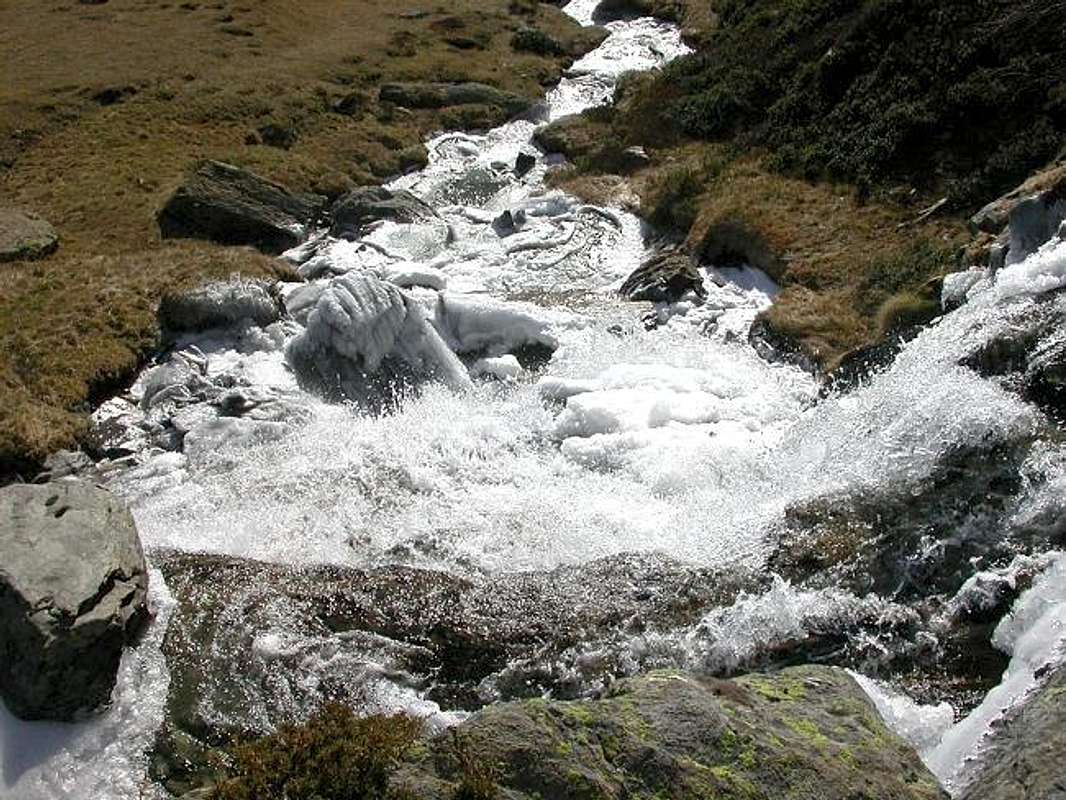
There are many glaciers, but even more the torrents that descend on the valley floor to the Dora Valgrisenche making itself more richer and very impetuous.Some are born directly from the overlying ice, others by a small lake that is formed by the continuous and gradual withdrawal of the same, and still others from underground sources at the time of taking life instantly appear in the light; individually, then, along the way, you gather together forming water courses more readily apparent
until you take the dignity of owning a name. But once all distinctly him, because they were the essential points for grazing and watering when the chief shepherd gave directions to the
"beiciullì" (young shepherd), where to take that day, the cattle did it with great precision and detail. The whole mountain was animated and permeated and entered into communion with the daily life of man. Cascades of water from all that, even without a specific name (once they had when the territory was known in the palm of your hand for grazing), flock to the valley with a twinkle extraordinary to say the least.
A dance of the water without any direction and no director from above, but with a particular choreography that only Mother Nature can offer.
Always admired and envied by those who come from outside the magnificent Aosta Valley.
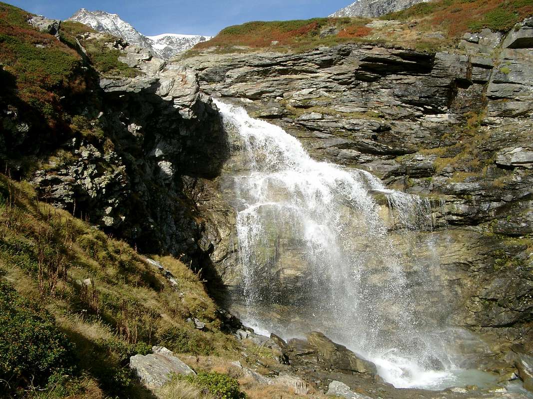
From Grande Sassière reaching Fond's Torrent
TORRENTS
Succession from North on watershed Rhêmes/Valgrisa Valleys to West
From Tos Glacier Boreigne Torrent to Chamin-Gasolay Villages.
From Becca Verconey Ramoua Torrent to Ramoua/Tséresoulaz Villages.
From Becca of Tos Torrent Theumelley to Gerbelle Village.
From Becca of Pré Damon Torrent Praz Londzet to Roncher Village.
From Becca of They/Point Rabouigne Torrent de Bouque to fork 1715 metres on Beauregard main road, Eastern shore.
From Mount Forciaz/Invergnaou/Giasson Glaciers Torrent Mount Fortchat to Chapuy Village.
From Southwestern slopes of Giasson Glacier Torrent Tsalé and La Tsa to Tsalé Pastures.
From Becca Giasson Torrent Giasson to Saxe Savoie Pastures.
From Saint Martin Glacier and Lake Torrent Saint Martin to Saxe Ponton-Saxe Savoie Pastures.
From Northern Point Bassac Torrent of Mans to alternative 2172 metres.
From Bassac Glacier, under Great Traversière, Torrent Bassac la Cuire to Vaudet Alp, neighbor Bezzi Refuge.
From the two Glaciers of Bassac Déré Torrent Bassac Déré to upper part of Valgrisenche Doire.
Succession from South on watershed Valgrisa/Val d'Isère Valleys to North
From Glairetta Glacier, between Becca of Traversière and Great Sassière, to Sources of Valgrisenche Doire.
From Vaudet Glacier, under Great and Little Sassière, Torrent Vaudet to Valgrisenche Doire.
Succession from North on watershed Valgrisa/Val d'Isère Valleys to East
From Glacier de Traversaz, below Fond Pass Torrent Traversaz to Doire.
From Glacier Lavellaz, under Nant Cruet Point, Torrent Lavellaz to Doire.
From Glacier Pattes of Chamoises, under Plattes de Chamois Point, Torrent Pattes de Chamoises to altitude 2272 metres above Bezzi Shelter. From Vert Glacier and Lake, below Becca de Suessa, various small Torrents Vert to Doire, under Vaudet Alp.
From Vaudet Hill Torrent Grapillon to (over) Saxe Ponton Pastures.
From Becca Percià also Pertcha Torrent de Gran Coussa to Saxe Savoie Pastures.
From little Loch Noir, below Loch Noir Pass, Torrent Loch Noir to Mont Blanc Alp.
From Maurin Glcier, under Maurin Point, Torrent Maurin to alternative 1894 metres above the Doire.
From Saint Grat Vallon (Suzei-Ormelune-Archeboc Glaciers, Col du Mont, Saint Grat Lake and Sachère Glacier) Torrent de Grand'Alpe to Usellières Village, near the Southern side of Beauregard Dam.
Succession from North on watershed Valgrisa/La Thuile Valleys to East-northeast
From Arp Vieille Vallon Torrent Arp Vieillle to Meillares Village and Dam.
From Morion Lakes, below Angels Refuge, Torrent Morion to Valgrisenche Chief-Lieu.
From Morion Glacier, under Testa del Rutor, Torrents Miollet, Dard to Miollet (renowned waterfall) and Céré/Darbelley Villages.
From Château Blanc Southern Glacier and Point Torrent Orfeuille to Revers Village.
From Château Blanc Northern Glacier-Planaval Pass Torrent Glacier to Glacier Alpages.
From Fond Loch Torrents Fond-Planaval to Planaval Hamlet.
From Northeast Slope of Mont Orfeuille Torrent les Aouilles to Moulin de Roset Village.
From Tignet or Tighet/Tonda Towers Torrent de Clusaz to Planaval-Maison Forte Village.
Molti i ghiacciai, ma ancor più i torrenti che scendon sul fondo valle verso la Dora di Valgrisenche rendendo la stessa sempre più ricca e veramente impetuosa.Alcuni nascon direttamente dai soprastanti ghiacciai, altri da un laghetto formatosi dal continuo e progressivo ritiro dei medesimi, ed altri ancora da fonti sotterranee prendendo vita all'istante nel momento d'apparir alla luce; singolarmente, poi, strada facendo, si riuniscono tra di loro formando corsi d'acqua maggiormente evidenti
finché prendon la dignità di posseder un nome. Ma una volta tutti distintamente lo avevano, perché eran punti essenziali di abbeveraggio per il pascolo e quando il capo dei pastori dava indicazioni al
"beiciullì" (giovane pastorello), dove portare in quella giornata il bestiame, lo faceva con grande precisione e dovizia di particolari. Tutta la montagna era animata e compenetrava entrando in comunione con la vita quotidiana dell'uomo. Cascate di acqua da ogni dove che, anche senza un nome preciso (una volta lo avevano quando il territorio era conosciuto sul palmo della mano per il pascolo), si riversano a valle con un luccichio a dir poco straordinario.
Una danza dell'acqua senza alcuna direzione o regista dall'alto ma con una coreografia particolare quale soltanto Madre Natura può proporre.
Sempre ammirata ed invidiata da chi proviene da fuori Valle.
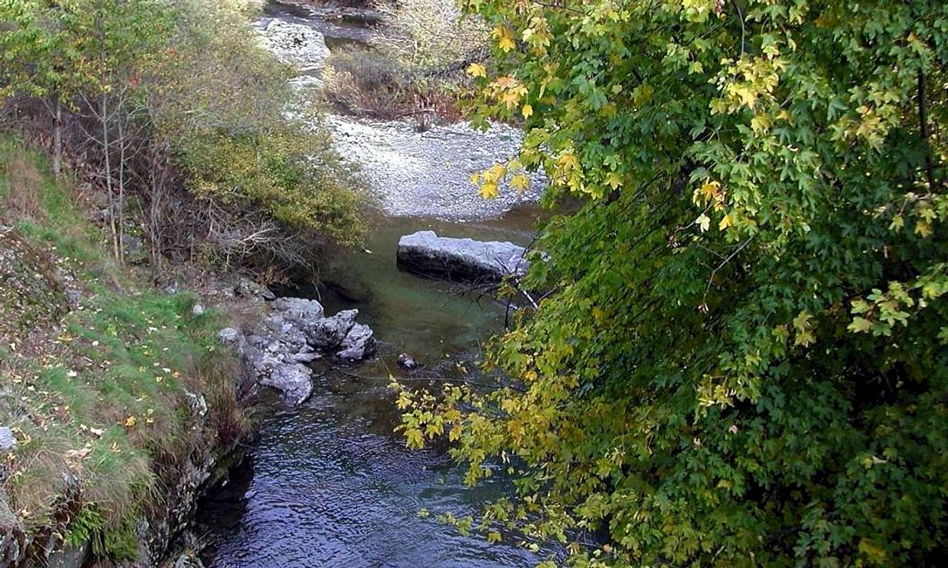
Grisenche's Waterfalls,
by marco979![]()
Comments
No comments posted yet.