Valley of Aosta fluvial pages: Plan of the Work

Valley of Aosta fluvial pages: Plan of the Work

Page Type Page Type: Trip Report
Location Lat/Lon: 45.73699°N / 7.31373°E
Date Date Climbed/Hiked: Dec 4, 2016
Activities Activities: Hiking
Seasons Season: Spring, Summer, Fall, Winter

Synthetic plan work Overview


This page is intended to summarize the entire and complete Work Plan with respect to the most important small Torrents and Sreams of across Aosta Valley.
Born a little so improvised in now distant December 17th, 2013 with "Grisenche Valley", this idea of analyzing the main vallons and the valleys that exist in Aosta Valley took the substance, along the way, with the publication of other works related to the same topic. But, previously, since September 16th of the same year had taken start another series devoted to the analysis of this analogous and kindred theme with "ALL PASSES from PIEDMONT to AOSTA VALLEY's into SOUTHEASTERN Graian ALPS", though primarily targeted at Hills and then to step between Valleys and Walloons different. Since November instead began with "AOSTA VALLEY Southern Orographic and Hydrographic VALLEYS & small Valleys - First Part/A" a more targeted and more specific in an organic (same topographical division of the recent work with the same dascrizione in clockwise rotation from East to West and back) that had ended, after the publication of six separate and specific pages, April 3th, 2014 with "AOSTA VALLEY Southern Or. & Hydr. VALLEYS & small Valleys - First Part/B". This work was more gaunt and "telegraphic" the current, but had the advantage of their visit all the vallons or small valleys existing into the Valley of Aosta. Two complementar works and apparently similar, but to propose such substantial differences, with the latter becoming more descriptive and interesting, even with the mention of Mountaineering, Hiking itineraries, and more connected to the fabric of a relative valley. So a goal more matured over time not prefixed in relation to the large amount of work to be performed and the commitment required. Purpose highlighting what has been done and what still needs to be realized is an invitation to anyone who wants to participate in the drafting of the various valleys and numerous small vallons that still have not been described, and of which you will find in the clear highlight panels, just below.

This applies to the important all waters description inside the same.

Logically this case study corresponds to a similar one on the course of the waters that run through the same. The same can sometimes be scored by lakes at the beginning or intermediates, as well as be "broken" by one or more cascades of water. A "musical song" accompanying the cheering scene beyond sight even the hearing.
Meanwhile it is to be noted that all of the South Sector compared to Baltea was completed with the last publication in March of the page relative to "Conca d'Arpy" or Arpy Basin.
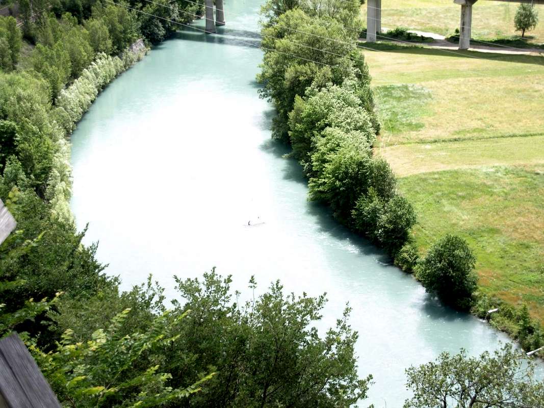
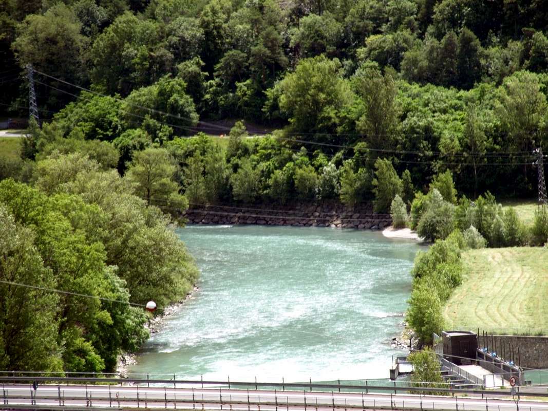


Dora Baltea towards Southeast in the middle Aosta Valley between Pontey & Châtillon Municipalities,

by Osw June 2016


Clockwise and from East to West, starting from the Common of Pont Saint Martin to get towards Valley La Thuile and the adjacent Vallon of Little Saint Bernard.
So the whole sector bordering the Valle Orco-Locana-Ceresole Reale in Canavese Zone (Piedmont), as well as the border between Italy and France with Val d'Isere and the Tarentaise Sainte Foy has been completed; incluincluding the Valley of Saint Barthélemy, still further North the entire Valley of the Gran San Bernardo including Conca (Basin) of By-Ollomont and Valpelline. Finally the three valleys "noble", namely: Valtournanche or Valley of Torrent Marmore and still of the Cervino also Matterhorn above Châtillon, the Ayas Valley or of Evançon also Lyskamms over Verrès and finally the Lys Valley or Gressoney with the highest part Chain Monte Rosa and the foothills to the Southern border with Piedmont up to the Mombarone. About Val d'Ayas, to note that five major small valleys of its watershed Eastern with the Lys or Gressoney Valley are already been edited; can be attached to complete, in the course of future description of this valley. The four main focal points of this artificial division into four specific sectors, over the course of Dora Baltea which acts as a divider between the net everything which stands in the North compared to that which is collocated to the South, can be considered from East to West the Commons Pont Saint Martin, Saint Vincent-Châtillon, Aosta and Courmayeur. But the "heart" or, if you prefer the primary pin, is to be located in the old City of Aosta, the real balance of power within the right of Aosta Valley in the middle of Graian & Pennine Alps, as incidentally had already identified 2040 years ago the Romans, clearly prosthesis on
"Ancient Via delle Gallie" toward France, but also interested to dominate all the Valleys with its secondaries Vallons, exploiting the rich resources from all waters.

*******


Aosta Valley Two main orographic and hydrographic divide for four principal Sector from East towards West & vice versa.

*******


Southern Area in respect to Baltea:


Champorcher Valley: Bard, Pont-Bozet, Champorcher Municipalities; Vertex on Mont Glacier (3186m).
Champdepraz or of Lakes Valley-small Valley: Champdepraz Municipality; Vertex on Mont Avìc (3006m).
Valmeriana-Bellecombe small Valleys: Pontey Municipality; Vertex on Mont Rouìc (2922m).
Ponton small Valleys: Fénis Municipality; Vertex on Mont Avìc (3006m).
Fénis-Clavalité-High Comba Tersiva-Savoney-Lavòdilèc Valley-small Valleys: Fénis Municipality; Vertex on Punta Tersiva (3515m).
Saint Marcel Valley: Saint Marcel Municipality; Vertex on Punta del Tessonet (3264m).
Les Laures small Valley: Grand Brissogne Municipality; Vertex on Monte Emilius (3559m).
Arpisson deep Valley: Pollein Municipality; Vertex on Monte Emilius (3559m).
Dard Gorge/Comboé Vallon: Charvensod Municipality; Vertex on Becca di Nona (3142m).
Arbolle or Arbole Vallon: Charvensod Municipality; Vertex on Monte Emilius (3559m).
Pila Basin: Charvensod, Gressan Municipalities; Vertex on Punta della Valletta (3090m).
Val de Cogne: Cogne Municipality; Vertex on Gran Paradiso (4061m).
Val Savarenche: Villeneuve, Valsavarenche Municipalities; Vertex on Gran Paradiso (4061m).
Val di Rhêmes: Villeneuve, Introd, Rhêmes-Saint-Georges, Rhêmes-Notre-Dame Municipalities; Vertex on Pointe Tzantelèina (3601m).
Grisenche Valley: Arvier-Liverogne, Valgrisenche Municipalities; Vertex on Grande Sassière (3751m).
La Thuile Valley: Pré Saint Didier, La Thuile Municipalities; Vertex on Tête du Rutor (3486m).
Little Saint Bernard small Valley: Pré Saint Didier, La Thuile Municipalities; Vertex on Mont Berrio Blanc (3252m).

*******


Northern Area than the Dora Baltea:

Val Vény: Coumayeur Municipality; Vertex on Mont Blanc (4810m).
Val Ferret: Coumayeur Municipality; Vertex on Grandes Jorasses (4208m).
Western Central Valley: Courmayeur, Pré Saint Didier, Morgex, Avise, Saint Nicolas, Arvier, La Salle, Saint Pierre, Sarre, Aosta Municipalities; Vertex on Grande Rochère (3326m).
Gran San Bernardo Valley: Aosta, Gignod, Allein, Etroubles, Saint Rhémy en Bosses Municipalities; Vertex on Mont Velan (3734m).
By Conca-Ollomont Valley: Aosta, Gignod, Allein, Doues, Ollomont Municipalities; Vertex on Mont Velan (3734m).
Valpelline: Roisan, Valpelline, Oyace, Bionaz Municipalities; Vertex on Dent d'Hérens (4175m).
Eastern Central Valley: Aosta, Saint Chistophe, Quart, Nus, Chambave, Verrayes, Saint Denis, Châtillon, Saint Vincent, Emarese Municipalities; Vertex on Monte Faroma (3073m).
Saint Barthélemy Valley: Nus, Saint Barthélemy Municipalities; Vertex on Becca di Luseney (3503m).
Valtournanche: Châtillon, Antey-Saint-André, La Magdeleine, Torgnon, Chamois, Valtournanche Municipalities; Vertex on Monte Cervino or Matterhorn (4478m).
Val d'Ayas with Estoul Basin, Frudière, Chasten, Dondeuil small Valleys: Verrès, Challant Saint Victor, Challant Saint Anselme, Brusson, Antagnod-Ayas-Champoluc-Saint Jacques Municipalities; Vertex on Eastern Lyskamm (4532m).
Lys or Gressoney Valley: Pont Saint Martin, Perloz, Lillianes, Fontainemore, Issime, Gaby, Gressoney Saint Jean, Gressoney la Trinité Municipalities; Vertex on Punta Zumstein (4564m).


*******


Pagina "intermedia" possiede lo scopo di sintetizzare il Piano di Lavoro completo rispetto a torrentelli e corsi d'acqua principali dell'intero territorio Valdostano.
Nata un pò in modo improvvisato nell'ormai lontano Dicembre 2013 con "Grisenche Valley", quest'idea di analizzare le principali valli nonché i valloni esistenti in Valle di Aosta ha preso sostanza, strada facendo, con la pubblicazione di altri lavori inerenti alla stessa tematica. Ma, precedentemente, già dal Settembre dello stesso anno aveva preso inizio un'altra serie dedicata all'analisi di questo tema con "ALL PASSES from PIEDMONT to AOSTA's VALLEY into SOUTHEASTERN GRAIAN ALPS, però principalmente rivolta ai Colli e quindi al passaggio tra valli e valloni diversi. Dal Novembre invece era iniziata con "AOSTA VALLEY Southern Orographic and Hydrographic VALLEYS & small Valleys - First Part/A" una serie più mirata, nonché maggiormente specifica che in modo organico (stessa divisione topografica del recente lavoro con medesima dascrizione in rotazione oraria da Est ad Ovest e ritorno) che s'era conclusa, dopo la pubblicazione di sei distinte pagine, il 3 di Aprile del 2014 con "AOSTA VALLEY Southern Or. & Hydr. VALLEYS & small Valleys - First Part/B". Questo lavoro era più scarno e "telegrafico" dell'attuale, ma aveva il pregio di visitare proprio tutti i valloni e valloncelli secondarii esistenti con gran numero nell'intera Valle di Aosta. Due lavori complementari ed apparentemente similari, ma tali da proporre sostanziali differenziazioni, con quest'ultimo che diventa maggiormente descrittivo, anche con l'accenno ad itinerari da percorrere, e più connesso al tessuto d'una specifica vallata. Quindi un obiettivo maggiormente maturato nel tempo che non prefissato, in rapporto alla grande mole di lavoro da svolgere e dell'impegno richiesto. All'uopo evidenziando ciò che é stato fatto e quello che deve essere ancora realizzato risulta un invito a chiunque volenteroso voglia partecipare a stesura di valloncelli e di valli che ancora non sono state descritte e delle quali trovate chiara evidenziazione nei panneaux appena sotto elencati.

Ciò vale anche per l'importante descrizione di tutte le acque all'interno ai medesimi.

Logicamente a questo studio analitico corrisponde uno analogo concernente il corso delle acque che solcano i medesimi. Lo stesso a volte può essere segnato da laghi all'inizio od intermedi, nonché esser "spezzati" da una o più cascate d'acqua. "Canzone musicale" accompagnante il panorama allietando oltre la vista anche l'udito.
Da annotarsi che tutto il Settore Meridionale rispetto alla Dora Baltea é stato completato con la pubblicazione in Marzo di "Conca d'Arpy", subito precedente la Valle di La Thuile.
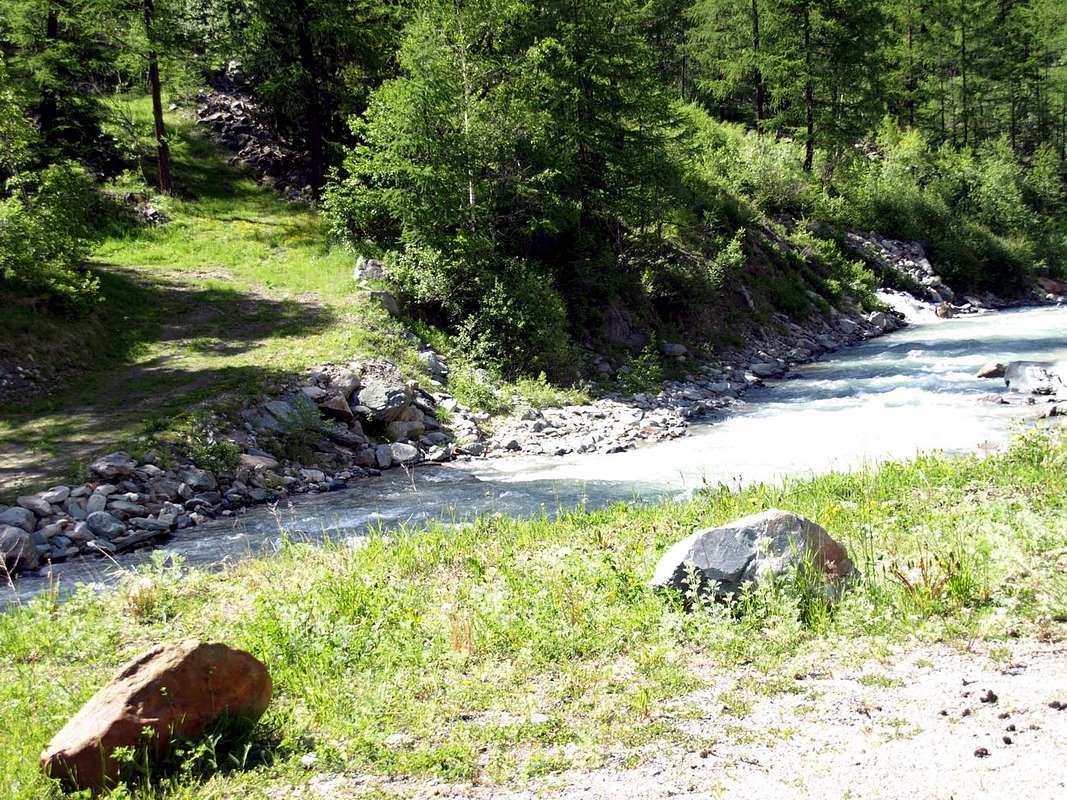
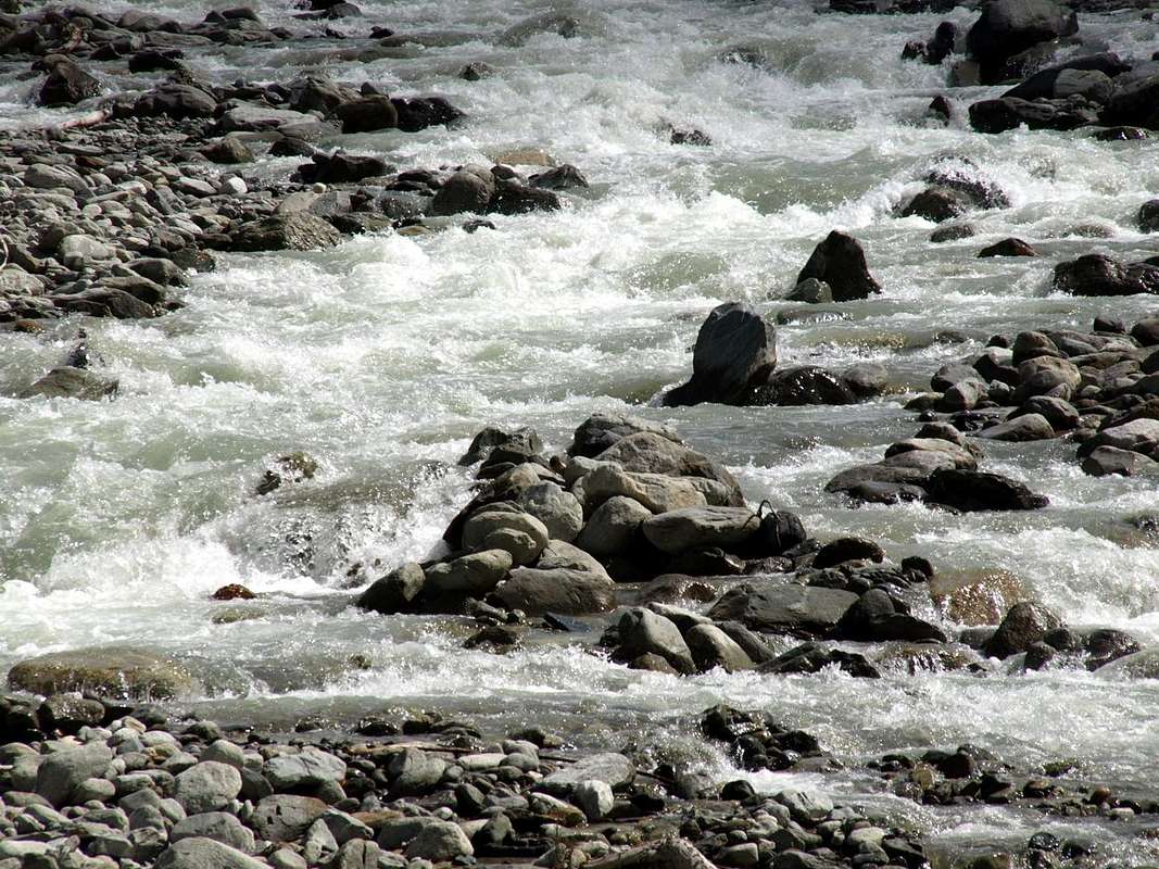


Savara Torrent between Eaux Rousses & Rovenaud Villages in Valsavarenche,

by Osw June 2016


Questo in senso orario e da Est verso Ovest, partendo da Pont Saint Martin per arrivare alla Valle di La Thuile ed all'adiacente Vallone del Piccolo San Bernardo. Quindi tutto il settore confinante con la Valle dell'Orco-Locana-Ceresole Reale in Canavese (Piemonte), nonché il confine italo-francese con la Val d'Isère e la Tarentaise Sainte-Foy é stato completato; comprese le aree più interne, che non arrivano ai confini, ma che quali zone intermedie discendono verso la Valle Centrale. La scansione temporale delle varie pubblicazioni non ha rispettato integralmente la giusta successione geografica e topografica mentre la medesima ha visto, proprio perché improvvisata come sopraddetto, pubblicare delle vallate in anticipo od in ritardo rispetto ad altre. Questo per motivi contingenti, spesso in concomitanza di altri lavori eseguiti in diversi titoli (esempio My Mountain, Article, Trip Report ecc) inerenti alla medesima area. Per questo motivo si preferisce qui dare due diverse chiavi di lettura: 1)- la giusta successione in senso circolare a 360° di vallate e valloni partendo da Est (Comune di Pont St. Martin) per ritornare ad Est sul Settore opposto o Settentrionale che, partendo dal Colle della Seigne all'inizio della Catena del Monte Bianco, termina ad Est con quella del Monte Rosa per infine concludere scendendo al confine con le tre Province di Novara, Biella e Torino (sempre Piemonte) sull'estremo spartiacque Orientale. 2)- Nella successiva tabella di "Déjà-vu or Already Seen" vengono invece descritte le pubblicazioni in senso cronologico, così come sono state pubblicate a suo tempo. Per completare questo lavoro manca ancora tutto il Settore Settentrionale rispetto al corso della Dora Baltea, che si può così brevemente delineare: le due vallate del Monte Bianco (Val Vény e Ferret), le due aree interne o Nordovest da Courmayeur (Mont de la Saxe) ad Aosta (Punta di Met) e Nord da Aosta (Becca di Viou) a Châtillon (Becca d'Aver), compresa la Valle di Saint Barthélemy. Ancora più a Nord l'intera Valle del Gran San Bernardo, compresa la Conca di By-Ollomont, e la Valpelline, ed infine le tre valli "nobili", ovvero: la Valtournanche o Valle del Torrent Marmore ed ancora del Cervino fino a Châtillon, la Val d'Ayas o Valle dell'Evançon o dei Lyskamms fino a Verrès ed infine la Valle del Lys o di Gressoney con la parte più elevata della Catena del Monte Rosa, nonché le propaggini Meridionali al confine con il Piemonte raggiungenti il piccolo Mombarone sopra i Comuni di Pont Saint Martin e Carema. A proposito della Val d'Ayas, da annotare che cinque importanti valloni del suo spartiacque Orientale con la Valle del Lys sono di già stati editati; potranno essere allegati, a completamento, nel corso della futura descrizione di questa vallata. I quattro fulcri principali di questa artificiale divisione in altrettanti specifici settori, oltre al corso della Dora Baltea fungente da netto divisorio tra tutto quello che rimane a Settentrione rispetto a ciò che é collocato a Meridione, posson essere considerati da Est ad Ovest i Comuni di Pont St. Martin, Donnas, Arnad, Bard, Montjovet, St. Vincent e Châtillon e quindi da Aosta raggiungendo la Valdigne e l"Alta Valle" sino a Courmayeur. Ma il "cuore" o, se preferite il perno primario della suddivisione in quattro specifici settori, é da situarsi nella vecchia Città d'Aosta, vero e proprio ago della bilancia all'interno dell'omonima Valle giusto in mezzo ad Alpi Graie e Pennine, come daltronde già individuato 2040 anni orsono dai Romani, sin d'allora decisamente protesi sull'
Antica "Via delle Gallie" ma pur sempre interessati a dominare su tutte le Vallate, nonché sui Valloni secondari sfruttandone tutte le ricche nonché copiose acque.


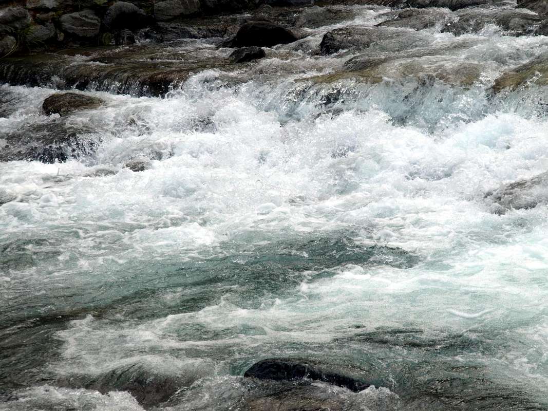
Artanavaz or Buthier de Bosses into Comba Merdeux in Great St. Bernard Valley,

by Osw May 1976


Enlarged Getting There to the whoole Aosta Valley

By car:

  • From TORINO, MILANO, etc: Motorway A5. Exit at IVREA or Quincinetto (PIEDMONT)

    From IVREA Town: in West (Northern side) towards Pont Saint Martin, Donnas, Bard, Arnad, Champdepraz, Saint Vincent, Emarese, Châtillon, also in Southern side: Pontey, Fénis, Saint Marcel, Grand Brissogne, Pollein, Charvensod, Gressan, Jovençan, Aymavilles, Villeneuve and from this returning again in Northern side: Arvier, Saint Nicolas, Avise, Morgex, Pré Saint Didier and Courmayeur Municipalities.

    From Courmayeur Resort: in East and in Norhern side respect to Baltea towards: Morgex, La Salle, Saint Pierre, Sarre, Aosta, Saint Chistophe; Quart, Nus, Chambave, Verrayes, Saint Denis, Châtillon, Saint Vincent, Emarese, Arnad, Verrès, Arnad, Hône, Donnas, Pont Saint Martin Municipalities.


    Southeastern, Southern and Southwestern Sides:

    From Hône-Bard towards La Thuile Valley and Little Saint Bernard Vallon

    From Hône-Bard towards Pont Bozet (775m) and from this to Champorcher Valley, Château (1427m), Petit, Grand Mont Blanc, La Cort Villages, towards Dondena Village (2092m), Dondena & Miserin Refuges, through Royal Road and dirt roads; Barbustel Refuge, through Royal Road and path towards Champdepraz Vallon.
    From Champdepraz (523m) to Lakes Walloon and Voella or Raye Chevrères Village (1307m; by Regional Road). Barbustel Refuge with path from Voella.
    From Fénis (537m) to Clavalité-Grand'Alpe Pastures (2129m; through dirt road), just below E. Borroz/Rotary-Clavalité Refuge (2156m) at Cuneu Alp.
    From Saint Marcel (630m) to Saint Marcel small Valley and Turati Reserve up to the Mulac & Grande Chaux Hunting Houses & Alp (1937m, 2370m).
    From Grand Brissogne (827m) to L'Arp, dirt road, Les Laures small Valley-Ernesto Ménabreaz Shelter at Lower Laures Lake (2546m), path-muletrack.
    From Pollein (575m; secondary road) or from Charvensod (746m; main road and connection) to Martsaouchy Damon-Arpisson wild Valley, through dirt road, and to Arpisson Lower and Upper (2010m) Alpages with path. To Federigo Zullo Bivouac (2907m), through moraines on Western Arpisson Glacier.
    From Charvensod to Dard-Comboé-Arbolle small Valleys towards Ponteilles (1697m) Alp/Waterfall, through dirt road, Comboé Alp/Saint Ours Shelter (2114m), through dirt road, and Arbolle Refuge (2516m), near Lakes (2497m), by Chair Lift to Chamolé Station (2309m), Lake (2325m) and muletrack.
    From Charvensod (main road from Pont Suaz 567m) or from Gressan (603m; alternative road) to Tivet, Les Fleurs Hamlets (1292m, 1414m) Pila Basin and Pila Resort (1800m); upper parking 1850m). Arno Shelter (2660m), always open but unguarded, nearby Couiss Summit on watershed Pila/Cogne Valley.
    From Jovençan (631m) to Pila Conca, exclusively through path-muletrack to Tourlin Dessous (1466m) and by dirt road to Pila-Posse Tennis (1776m).
    From Aymavilles (646m) to Western Pila Conca, through Main Road to Cogne Valley, alternative to Ozein/Turlin Dessus Hamlets and dirt road to Pila-Posse.
    From Villeneuve towards Savara Valley or Valsavarenche
    From Villeneuve to Savarenche Valley, Dégioz-Valsavarenche (1541m) up to the Pont Valsavarenche (1946m). From this or neighbor to Federico & Renato Chabod, below North Buttress of Gran Paradiso and nearby Laveciaù Glacier; Vittorio Emanuele II° (Old & New), between Gran Paradiso and Montcorvé Glaciers.
    From Villeneuve to Rhêmes Valley
    From Villeneuve (670m) to Rhêmes Valley: Introd (880m), Rhêmes Saint Georges (1171m), Notre Dame (1725m) Communes, through Regional Main Road, up to the Thumel Village (1887m) with Municipal Road and to Gian Federico Benevolo Refuge (2280m), through dirt farms road or underlying path.
    From Liverogne (Arvier) to Valgrisenche
    From Arvier to Liverogne Fraction (730m) and from this to Valgrisenche Valley, up to the Valgrisenche Municupality (1664m) and Mondanges, Surier, Us(s)eliéres Villages around the artificial Beauregard Dam, through Regional Road. Mario Bezzi at Vaudet and Chalet de l'Epée Refuges through paths.
    From Pré Saint Didier to La Thuile & Little Saint Bernard Valleys
    From Pré Saint Didier (1010m), with State Road, to La Thuile Valley: Elévaz, Balme Villages, La Thuile Commune, 1441m; from this to Little Saint Bernard small Valleys towards the Little Saint Bernard Hill (2188m), through State Road. To Albert Deffeyes Refuge with muletrack from La Joux Fraction.

    Internal Dora Baltea Areas from Villeneuve to Arpy Conca
    From Villeneuve (620m), Martignon (823m), San Bernardo through dirt road in Southeast, towards Prorayé Alp to Upper Champlong in Poignon small Valley.
    From Introd (873m), with Municipal or dirt road towards Buillet (1030m)/Biolay (1042m) small Villages to Montagne.
    From Arvier (776m), with Regional Road, towards Crête, Verney, Petit Haury, Scierie, Grand Haury with Municipal Road, to Combes Basin.
    From Avise-Runaz (786m), with Municipal Road, to forks 956, 998, 1115 metres, Marbrière Pasture, Faveroy Alp to Monte Colombo.
    From Derby-Chez Les Gontiers (839m) Village, with short Municipal Road through path in South towards Créton (1523m), Dailley (1621m) Alpages. Through two parallel secondaries small paths, to fork 1823 metres with dirt road and Tillac Alp (1848m) to Faveroy Area.
    From Morgex (920m), with Regional Road in South, towards Liarey, Pre Villair, Mont Rotie, alternative around 1275m just before Tirecagne Pasture (1532m), with dirt road in Southeast, towards Costablinaz de Meitin Pasture (1420m), after through path, towards Damon (1445m), Champex (1519m) Pastures, Plan Rançon Alp (2098m) to Becca Pouignenta Northern Area.
    From Morgex (920m), crossing the bridge above Baltea with Regional Road in South, towards Liarey, Pre Villair, Mont Rotie small Villages, alternative around 1275m) just before Tirecagne Pasture (1532m) and the Main Roads to Arpy Basin.

    Western, Northwestern and Northern Sides:

    From Courmayeur to Aosta Town

    From Courmayeur (1198m) towards Pont des Chèvres, Notre Dame de la Guérison, Lassy Dèsot/Perthud Villages, Gabba, Chalets du Miage, La Visaille Cave, Plan de Lognan Alp (1676m), with Municipal Road; from this to Lake Combal (1950m) and to Refuge Elisabetta-Soldini (2197m), through dirt road.
    From Courmayeur-Notre Dame de la Guérison Sanctuary (1444m), through private dirt road, to Monte Bianco Refuge (1666m).
    From Courmayeur-la Palud (1370m), towards Montitaz, Planpincieux (1593m) Villages, Tronchey (1620m), Praz Sec du Milieu, Lavachey (1640m), Arnouva Dèsot (1769m) Villages, through Municipal Road, to Malatrà Vallon and Walter Bonatti Refuge. Also from Arp Nouva to Elena Refuge, through dirt road on valley floor; or from the fork after Planpincieux, small bridge, towards Leuchey Dèsott, Damon Pastures to Mont de la Saxe Hump/Giorgio Bertone Refuge.
    From Courmayeur-Villair Dessus (1282m), with Municipal Road and through dirt road to fork 1470 metres and path to Refuge Bertone in Val Sapin.
    From La Salle 1001m), with Regional Road, towards Challancin (1610m), Cheverel, Morges (1829m), Planaval Hamlets (1750m); from this, through dirt road in North-northeast, passing Maison Blanche Pasture, to Rantin (2333m) and Bonalé (2340m) Alpages, in Upper Planaval small Valleys.
    From La Salle, with Regional Road, towards Challancin Village, Ponteilles (1741m), Arpilles (1862m) Pastures to Bard Pass (2178m) in Arpilles Conca.
    From Saint Pierre-Pommier (783m), Champretavy, Rumiod, alternative just after Persod (1351m), Ravoise, Chaillod, Clavel, Cerlogne (1580m) to Vens small Villages (1750m), with Regional Road in West-northwest. From this last to Joux Saddle (1930m): through short descent to Vertosan small Valley
    From Saint Pierre-Château Sarrod de la Tour, Rumiod, Petit and Grand Sarriod (1444/5m), Gerbore, Vetan Dessous (1670m) and Dessus (1737m), with Regional Road to Vetan Basin. From this, through dirt road, towards Genevrine Pasture, Chatalanez, Toules, Grand Arpilles Alps to Chaz Creuse Alp (2398m).
    From Sarre (657m), with Regional Road, towards Plèod, Vert Dessous and Dessus, Vareille, Caillod/Ville sur Sarre/Remondet, Moulin/la Cort, forks 1225, 1301 metres, Salet, Chavalançon (1426m) small Villages to Thouraz Dessous and Dessus Hamlets (1652m); from the last to Closella and Met small Valleys.


    Northern and Eastern Sides than in the course of Dora:

    From Aosta Town to Verrès Municipality

    From Saint Christophe-Prevot (about 640m), reached by Regional Road from Aosta, to Sorreley Village; from this, with Municipal, towards Veynes Fraction.
    From subsequent alternative before Lumian (1025m): *** in East deviation to Cretallaz, Jeanceyaz, Morgonaz Villages at the entrance on Senevé Comba).
    On asphalt road in Northwest, to Parléaz Village (1274m), Blavy Hamlet (1475m) and, through dirt road or path, to Viou Alpages, in Blavy Viou Basin.
    From Quart-Villair towards Epilaz, Argnod Villages or from State Road n° 26 nearby La Plantaz (540m), with Regional and Municipal Roads, towards Chétoz, Vignil, Fornail, Ville sur Nus-Planeville, Buignod, Porsan Villages to Trois Villes-Avisod Village (1398m). From this to Senevé Alps (2206m), in Senevé Comba.
    From Quart to Fonteil with previous route; from this through dirt road, towards La Seyvaz (2184m), Valchourda Alps (2392m), in Comba Dèche.
    From Nus-La Plantaz in State Road to Ville sur Nus-Planeville (1113m); from this, towards Buignod, Avion (1312m) Villages. Also from Porsan through Trois Villes (1398m), Avion, fork (1250m) to Effraz Village (1487m), with Municipal Roads. From this to Ronc (1737m), Machaussy Alps, in Effraz Comba.
    From State road n° 26, nearby Chambave, to Regional Road; towards Ollières, Marseiller (801m) to Verrayes (991m). With Municipal Road towards Tessellaz, Marquis, Dorinaz (1323m), Charrière Villages to Grand-Villa Hamlet (1437m), in Verrayes/Saint Denis Basin and to Aver-Longhede Area.
    From A)- Verrayes, with Regional Road, towards Del (1260m), Plau (1305m), Semon to Cheresoulaz (1487m) Villages. Also from B)- Saint Denis (803m; reached from Chambave, Marseiller) with Regional Road towards Gubioche, Etrobleyaz, Petit Bruson, to Del Villages. C*** Road Connection towards Roves, Lozon (1520m), Clavon, Fontane Villages, Pastures to Bornes Alp). From Cheresoulaz, through Municipal/Regional Roads, to Saint Pantaléon Hill (1650m).
    From Châtillon (549m), with Municipal Road, towards Chavod, Domianaz to Nissod Villages (1371m); from this, through dirt road to Nuarsaz Alp (1713m).
    From Saint Vincent (575m), with Regional Road, towards Moron (844m), Grun (991m), Salirod (1102m), Amay (1466m) Hamlets to Joux Hill (1635m).
    From Saint Vincent, towards Cillian, Feilley Villages also from State Road n° 26, towards Estaoud (595m), the both with Regional Roads, to Emarese Commune (1048m); from this towards Erésaz (1163m), Cuignon/Sommarèse/Longeon (1549m, 1536m, 1516m) Hamlets to Zuccore Hill (1607m).
    From Verrès (390m), before with Regional Road after through path, to Collegiate Church of Saint Gilles, immediately below Mount Saint Gilles (967m).


    Southwestern Side of Northwestern Area:

    From Aosta Town to Merdeux Basin

    From Gignod Commune (988m) with Great Saint Bernard State Road n° 27 to alternative nearby Condemine Hamlet (1137m); leaving left through Municipal Road to Grand e Petit Buthier Villages (1302m, 1439m) in Chaligne Comba. From this last, with private dirt farms roads and through Mendey, Roncaille, Rombason Pastures up to the Chaligne Shelter (1936m), below Costa Tardiva (2380m), Tardiva Hill (2410m) and neighbor the Punta Chaligne (2608m).
    From Etroubles Commune (1270m), with dirt road and through Champ-Reclos (1425m), Yettes (1591m), Eteley (1716m), fork before Praz-Gallet (1626m), Ars (1975m) Pastures on Arsy small Valley, up to Chaz d'Arsy (2543mn); from this paths to Ars Pass (2534m), Costa Labiez (2632m).
    From Etroubles Commune (1270m), with dirt road through Champex (1411m; fork), Flassin de Meitin (1654m), Flassin (1700m), Tsa de Flassin (2258m) Pastures on Flassin small Valley; from this paths to Fenêtre Pass (2729m), Flassin Hill (2605m), Testa Cordella (2663m) and Tête Bois de Quart (2248m).
    From Saint-Oyen Commune (1377m), with State Road n° 27 to alternative 1502 metres; leaving North the same to great St. Bernard Hill, continue West to St. Leonard Fraction. From this to Citrin small Valley up to the Mont Flassin (2772m) Citrin Hill (2484m), Punta Valletta (2801m) and La Raye du Sodzé (2640m).
    From Saint-Oyen Commune (1377m), with previous Municipal Road to Mottes (1660m) Fraction, Farettes (1666m) Village; from this, with path through Arp du Bois Dèsott Pastures (1936m), alternative 1959 metres to Serena small Valley up to the Hill Serena (2547m) and Testa Serena (2830m). Variant: continue West from Farettes Village to Saint Michel (1732m) Fraction; from this last, tourning South always with Municipal Road, to Arp du Bois Dèsott Pastures.

    Northwestern Side relative to the position Gran San Bernardo State Road:

    From Malatrà Hill to Grand Saint Bernard Basin Basin up to the

    From Saint-Oyen (1377m), with previous road to Mottes, continue West-northwest to Devies Village (1723m) at the beginning of Merdeux Comba; from this with paths through Merdeux Dèsott (1919m), Cotes (1930m), Manda (1973m), Tsa de Merdeux (2285m) Pastures to Malatrà Hill (2928m).
    From Saint Rhémy en Bosses Commune (1619m), through Municipal Road, on Merdeux Comba to Tsa de Merdeux (2285m) and Malatrà Hill (2928m).
    From Saint Rhémy en Bosses Commune (1619m) to Tula Comba to Saulié Pass (2817m), Aiguille des Cengles (2869m) and Angroniettes Pass (2936m).
    From Saint Rhémy en Bosses Commune (1619m) to Grand Saint Bernard Valley up to the Crévacol Hill and Testa (2498m, 2610m) Saint Rhémy Hill (2540m), Mont Rodzo (2632m), Pain de Sucre (2900m), Mont Fourchon (2902m), Fenêtre de Ferret Hill (2600m) and Grand Saint Bernard Hill (2469m).


    Northern Side compared with the position of the Aosta City:

    From Allain/Doues to Ollomont/Valpelline Communes with By Basin

    From Allein Commune (1251m), with Regional and Municipal Roads, to By Basin; from the entrance of this (various alpages reached by private dirt farms roads), through paths, up to the Mont Saron Southern Antesummit (2681m) and traverse on crest to Tete de la Praz (2751m) and Crou de Bleintse (2824m).
    From Doues Commune (1176m), with in asphalt Municipal Road, to By Basin; from this, with paths or dirt roads, to Mont Saron (2681m), Crou de Bleintse (2824m), Letey Refuge below Champillon Pass (2430), Mont Chenaille two Summits (3144m), Tsa d'Ansermin (2388m) and Monte Rotondo (2572m).
    From Ollomont Commune (1356m), trhough noumerous paths and variaous upper dirt farms roads, to By Conca; from this various routes in all directions up to the Maria Cristina Rosazza at Savoie Bivouac (2674m), Refuge Franco Chiarella-Amiante (2979m), Filon Alp (2478m), Bonne Mort Pass (2646m), Fenêtre Durand Hill (2797m), Nino Regondi Bivouac (2599m) and Lakes, Tsa de Berrio Alp (2165m), Cormet Hill (2354m) and Breuson Hill (2194m).

    Northeastern Side relative to the position of the City of Aosta:

    From Valpelline towards Valpelline Valley

    From Valpelline (580m), with Regional Road, to Oyace Commune (1316-1377m); from this to Northern and Southern Walloons (Brison, Crête Sèche, Vertsan, Comba be la Tsa, Comba du Grand Chamin, Comba des Lacs and Comba d'Orein up to the entrance on Petite/Grande Murailles/Valpelline Hill small Valley.
    From Oyace (1377m), with R.R., to Bionaz Commune (1612m) and Places Moulin artificial Dam (1970/80m) and Northern and Southern Vallons (Bella Tsa, Combes de Valcornière, Livourneaz, Montagnayes; Vessonaz, Verdonaz, Vieille, Verdzignolaz, Arpisson, Gran Comba and Roisan-Praperiaz Basin.

    Northern Sides than in the course of Baltea:

    From Nus, Châtillon, Verrès, Pont Saint Martin Municipalities towards Saint Barthélemy, Valtournanche, Val d'Ayas and Gressoney Valleys

    From Nus (960m), with Regional Road, to Lignan-Saint Barthélemy Municipality; from this, through various dirt roads and numerous paths, (1628m) up to the Becca de Luseney (Luca Reboulaz Bivouac (2575m neighbor the Luseney Lake), Livourneaz Pass 2840m and Cian Fenêtre (2736m)).
    From Châtillon (549m), with Regional Road, to Valtournanche and Breuil Cervinia Municipalities (2004m); from this, through paths in West, to Tsan Bivouac, Lake (2489m, 2441m), Cignana Lake (2149m) or, through dirt road and paths more in East, to Gran Sometta (3166m).
    From Verrès (549m), with Regional Road, to Champoluc and Saint Jacques Communes (1697m); from these, path in West, to Grand Tournalin Refuge (2544m). From shelter, through path in North, to Mont Brun (2895m); also in valley floor to Lake Bleu (2211m) and in East to Pinter Pass (2776m).
    From Pont Saint Martin (345m), with Regional Road in Gressoney Valley, to Gressoney La Trinitè (1468m); from this, through dirt roads and paths in East, up to the Upper Bettolina Pass (3058m); also in West to Gabiet Loch (2363m) and from this, with path, to Corno del Camoscio (3026m).


  • From FRANCE: through the Mont Blanc Tunnel to Entrèves-crossroads to Vény/Ferret Valleys - Mountain Guides of Courmayeur - La Saxe Rock Gym - Courmayeur. By Little Saint Bernard Pass, closed since November until half May to La Thuile Valley - Pré Saint Didier - Courmayeur.

  • From FRANCE: through the Mont Blanc Tunnel to Entrèves-crossroads to Vény/Ferret Valleys - Mountain Guides of Courmayeur - La Saxe Rock Gym - Courmayeur. By Little Saint Bernard Pass, closed since November until half May to La Thuile Valley - Pré Saint Didier - Courmayeur.

    It is not necessary to take Motorway A5: you can drive on State Road n° 26, in the direction of AOSTA - IVREA - TURIN.


By plane:

  • Aeroporto Internazionale "Corrado Gex" Saint Christophe (Aosta)


Déjà-vu or Already Seen


Savara Torrent from Gran Paradiso Mountain Chain nearby Fenille Hamlet,

by Osw June 2016


This box summarizes all valleys and gorges until now published and edited in SP, to which we attach an intimate marriage with a visit to their rivers & torrents.
As already explained in the same Overview not follow a strict topographic scanning in Sector Southern than in the course of Dora Baltea River, which however has been completed from East to West or from the "Lower Valley" towards the "Higher Valley" with Mountain Chain of Mont Blanc. Also have already been edited five vallons on the Val d'Ayas or of Torrent Evançon to Verrès Town, which anticipate the work in the North still almost completely to play. Moreover, as already above specified, lists six previous work on Valleys and Vallons of the whole Aosta Valley, are part of a series forerunner to this work, and more focused on the research of all the existing vallons, including the secondaries, smaller or semi unknown. Begun in September 2013, and concluded in April of the following year, offers the same features of the current and larger work but is more addressed to the "discovery" of the vallons than to a thorough scrutiny of the valleys. In any case, for all we know, can be considered an original work and unique; definitely complementary to the last of which can be seen as introductory and upon completion. The same job, turned to the valleys, he begins to find an "extension" to the discourse that is relevant to their rivers and streams of the same. To that end we find a first initiative with "In every Valley ... Rio Artanavaz (Arsy-Flassin-Citrin-Serena-Merdeux) 4" of February 10th, 2016 followed by a March 2th, 2016 with "In every Valley ... Torrents Buthier (Etroubles-St. Rhémy-en-Bosses-Ollomont-Valpelline) 5", both included in "My Areas & Ranges". From this initial and more descriptive idea it is moved to a more "exploratory phase" going to visit the streams or even the small torrents of the Aosta Valley, if not totally, at least in part of their course. The result is a combination of valleys and streams or torrents which then becomes more specific to the latter starting from "Along various & Dora Baltea (Southern Side)", edited June 16th, 2016. This first part, facing the Southern catchment waters area, is balanced against the next "Along various Torrents towards the Dora Baltea (Northern Side)" of July 17th, 2016 addressed to the Northern fluvial sector. So we will proceed with a single as "Along Grand'Eyvia towards Dora Baltea", or at most "grouped", analysis of the various streams as "Visiting seven Torrents complementary to Dora Baltea" of this December 4th 2016.
An idea to be implemented with projected speech to a long series of journeys and explorations for the next 2017, by this coming winter until early next 2018 ...

***


NOTEWORTY "READING ROOM" published in SUMMITPOST.org. to bring in My Areas & Ranges or in My Trip Reports

since February 2016 until November 2017:


In every Valley ... Rio Artanavaz (Arsy-Flassin-Citrin-Serena-Merdeux) 4, by Osvaldo Cardellina; Edit. Feb 10th, 2016.
In every Valley ... Torrents Buthier (Etroubles-St. Rhémy-en-Bosses-Ollomont-Valpelline) 5, by Osvaldo Cardellina; Edit. Mar 02th, 2016.
Along various Dora & Baltea (Southern Side), by Osvaldo Cardellina; Edit. Jun 16th, 2016.
Along various Torrents towards the Dora Baltea (Northern Side), by Osvaldo Cardellina; Edit. Jul 17th, 2016.
Along Grand'Eyvia towards Dora Baltea, by Osvaldo Cardellina; Edit. Oct 27th, 2016.
Visiting seven Dora Torrents complementary to Baltea, by Osvaldo Cardellina; Edit. Dec 04th, 2016.
Where does the Ayasse down to the Dora Baltea, by Osvaldo Cardellina; Edit. Jan 02th, 2017.
Mont Blanc ... where the Dora Baltea born, by Osvaldo Cardellina; Edit. Feb 06th, 2017.
From Gran San Bernardo to Rio Artanavaz through Buthier des Bosses, Artanavaz & Menouve, by Osvaldo Cardellina; Edit. Mar 09th, 2017.
Savara the Stream of Gran Paradiso, by Osvaldo Cardellina; Edit. Apr 20th, 2017.
Rhêmes's Doire, by Osvaldo Cardellina; Edit. Jun 09th, 2017.
La Thuile & Verney Doires, by Osvaldo Cardellina; Edit. Aug 11th, 2017.
Valgrisenche Doire & Fond Torrent, by Osvaldo Cardellina; Edit. Nov 04th, 2017.


*******


In questo riquadro vengon riassunte tutte le valli ed i valloni fino ad ora pubblicate in SP, alle quali alleghiamo stretto connubio con visita ai loro fiumi e torrenti.
Come già ampiamente spiegato in Overview le stesse non seguono una scansione topografica rigorosa nel Settore Meridionale rispetto al corso della Dora, che comunque é stato completato da Est ad Ovest ovvero dalla "Bassa Valle" fino alla Catena del Monte Bianco. Inoltre son già stati editati cinque valloni concernenti la Val d'Ayas, anticipanti il lavoro nel settore Settentrionale, ancor quasi completamente da svolgere. Perdipiù, come sopra specificato, vengono elencati sei precedenti lavori concernenti Valli e Valloni dell'intera Valle d'Aosta, facenti parte di una serie antesignana a questo lavoro e maggiormente rivolta alla ricerca di tutti i valloni esistenti, compresi i secondari nonché i più piccoli. Iniziata a Settembre 2013 e conclusa in Aprile dell'anno successivo, ripropone le stesse caratteristiche dell'attuale e più ampio lavoro ma é maggiormente indirizzata alla "scoperta" dei valloni che non ad una disamina approfondita delle vallate. Per quel che ne sappiamo, può essere considerato un lavoro originale e probabilmente unico; sicuramente complementare a questo del quale può essere visto come introduttivo ed a completamento. Il medesimo lavoro, rivolto alle valli, incomincia a trovare un "ampliamento" con il discorso che riguarda i fiumi ed i torrenti propri delle stesse. All'uopo riscontriamo una prima iniziativa con "In every Valley ... Rio Artanavaz (Arsy-Flassin-Citrin-Serena-Merdeux) 4" del 10 Febbraio 2016 seguita da una del 02 Marzo 2016 con "In every Valley ... Torrents Buthier (Etroubles-St. Rhémy-en-Bosses-Ollomont-Valpelline) 5", entrambe inserite in "My Areas & Ranges". Da questa idea iniziale e più descrittiva si é passati ad una fase più "esplorativa" andando a visitare i torrenti della valle di Aosta, se non totalmente almeno in parte del loro percorso. Nasce così un connubio tra valli e torrenti che poi diventa sempre più specifico verso questi ultimi iniziando da "Along various Dora & Baltea (Southern Side)", editato il 16 Giugno 2016. Questa prima parte, rivolta al settore idrografico Meridionale, viene contro bilanciata dalla successiva "Along various Torrents towards the Dora Baltea (Northern Side)" del 17 Luglio 2016 rivolta al settore Settentrionale. Procedesi con singola come "Along Grand'Eyvia towards Dora Baltea", od al massimo "raggruppata", analisi dei corsi d'acqua come per "Visiting seven Dora Torrents complementary to Baltea" di questo 4 Dicembre.
Un discorso proiettato verso una lunga serie di viaggi ed esplorazioni per il prossimo 2017, a partire da quest'imminente inverno insino all'inizio del prossimo ...


Almost mystical religious Pont-Bozet old stonebridge above Ayasse Torrent,

by Osw June 2016


Comments

No comments posted yet.