
-
 53617 Hits
-
 94.44% Score
-
 47 Votes
|
|
Area/Range |
|---|---|
|
|
46.45578°N / 11.61973°E |
|
|
Hiking, Trad Climbing, Sport Climbing, Aid Climbing, Via Ferrata, Skiing |
|
|
Spring, Summer |
|
|
9850 ft / 3002 m |
|
|
What's new on this page?
PAGINA COMPLETA DI TRADUZIONE IN LINGUA ITALIANA - THE ITALIAN TRANSLATION ADDED TO THE PAGE (2021, February)
Overview
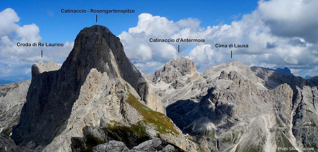
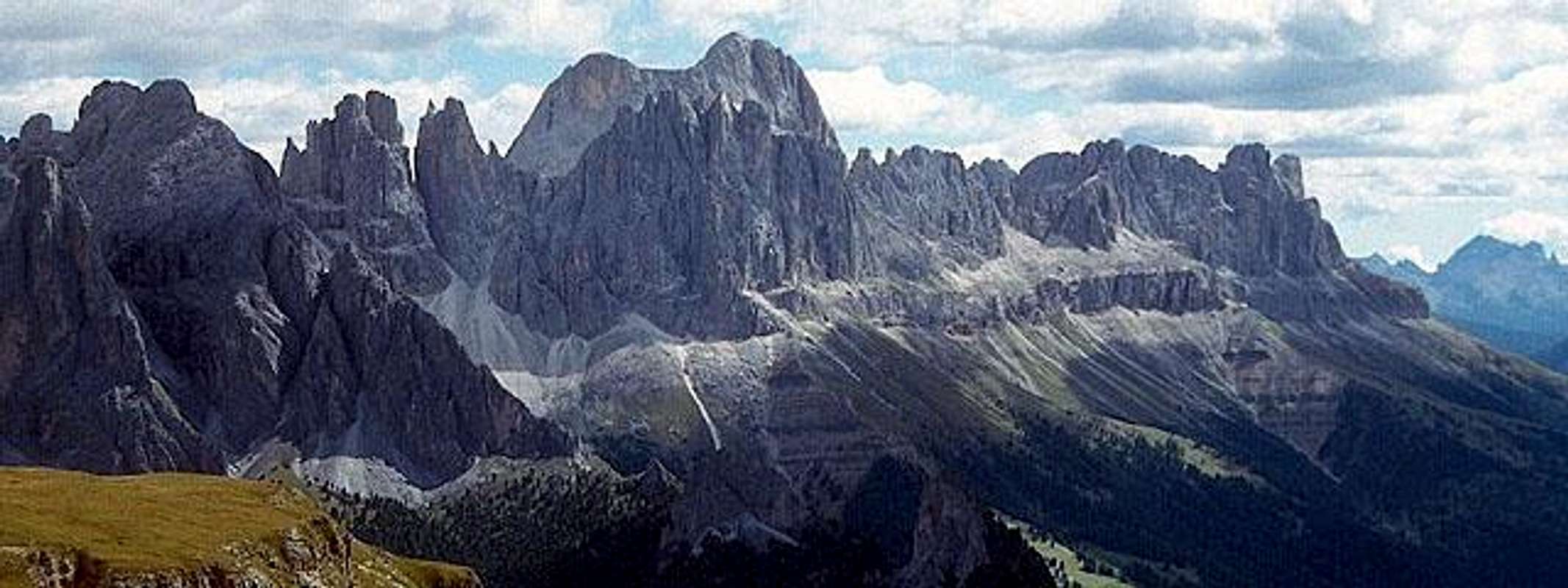
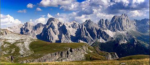
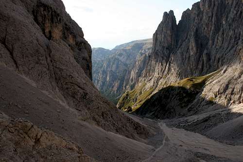
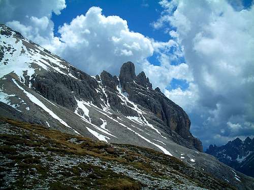
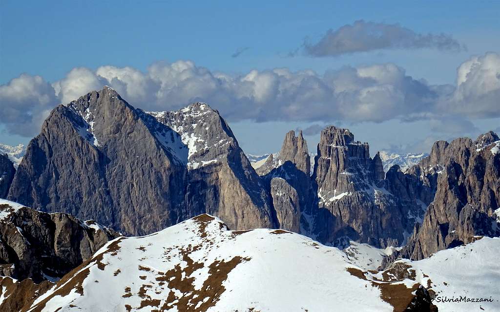
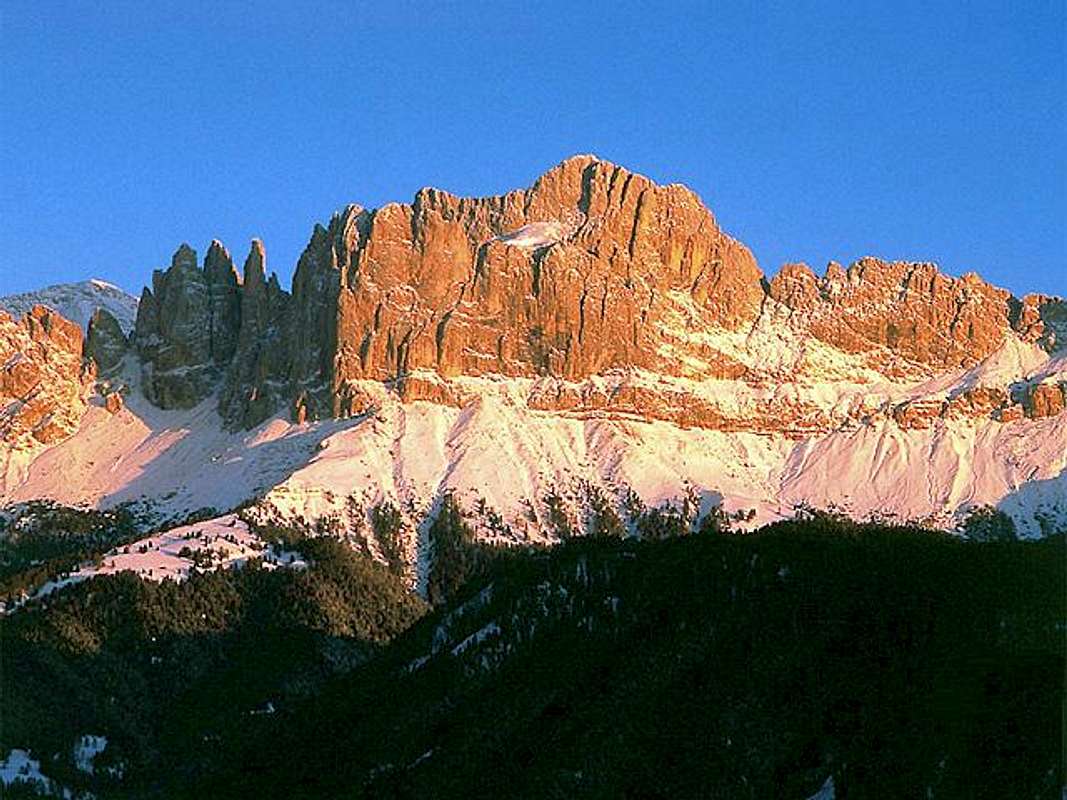
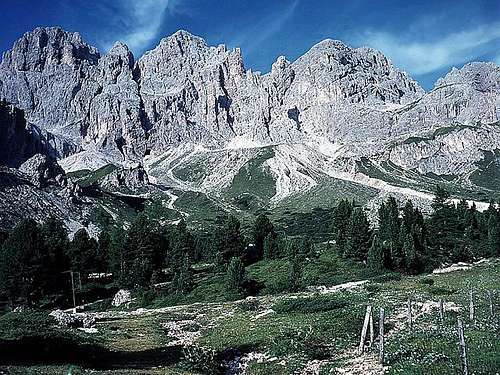
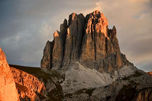
The Catinaccio Group - also known as Rosengarten, German name in use on the South-tyrolean side of the massif - is a fine and famous group belonging to the Western Dolomites and located among the Val di Fassa, the Val di Tires and the Val d'Ega. The highest peak of the group is the Catinaccio d'Antermoia 3004 m. Cima Catinaccio 2981 m is the second highest summit of the group, after Catinaccio d’Antermoia, this latter being the only summit in the group exceeding the 3000 meters.
The Catinaccio group has a quite simple structure, just as a big ridge oriented North-South, starting from Seiser Alm (Alpe di Siusi) and ending with the Passo di Costalunga (Carer Pass). Highly frequented in summer from the hikers, because of fine sceneries and paths that cross it, and from the climbers. The Vajolet towers, three spires that even if lower are as famous as the Lavaredo, are the sector more popular with alpinists. Moreover the Roda di Vael, with its big red wall which you can see from Carer Pass, and Catinaccio East wall, with many fine routes very difficult and fine routes, recall the climbers' attention in a particular way. The Catinaccio group is also very popular with advanced hikers and scramblers, due to the presence of some Via Ferrata, such as those of the Catinaccio d'Antermoia and Santner.
The most frequented way to amuse this group is getting it from Val di Fassa, on the East side (Trento). Gardeccia (above Pera di Fassa) is the central point from where to begin several hikes and climbs. Another approach may be done from Passo di Costalunga and from the road between Passo Nigra and Passo di Costalunga.
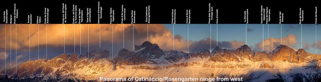
The Catinaccio Group is divided into eight sub-groups:
Principe, Molignon-Antermoia, Valbona, Larsec, Catinaccio Centrale, Roda di Vael, Coronelle-Mugoni and Dorsale Nigra-Montalto. In the following chapters the most important among them will be described.
Il Gruppo del Catinaccio - noto anche come Rosengarten, nome in lingua tedesca in uso sul versante altoatesino del massiccio - è un famoso gruppo appartenente alle Dolomiti Occidentali e situato tra la Val di Fassa, la Val di Tires e la Val d'Ega. La vetta più alta del gruppo è il Catinaccio d'Antermoia 3004 m. Cima Catinaccio 2981 m è la seconda vetta più alta del gruppo, dopo il Catinaccio d'Antermoia, unica vetta del gruppo a superare i 3000 metri.
Il gruppo del Catinaccio ha una struttura abbastanza semplice, proprio come una grande cresta con orientamento Nord-Sud e con inizio dall'Alpe di Siusi e fine al Passo di Costalunga (Passo Carer). Molto frequentato d'estate dagli escursionisti, per i bei paesaggi e sentieri che lo attraversano, e dagli alpinisti. Le torri del Vajolet, tre guglie che anche se più basse sono famose come le Lavaredo, sono il settore più frequentato dagli alpinisti. Inoltre la Roda di Vael, con la sua grande parete rossa visibile dal Passo Costalunga, e la parete Est del Catinaccio, con molte belle vie anche di notevole difficoltà, richiamano in modo particolare l'attenzione degli alpinisti. Il gruppo del Catinaccio è molto frequentato anche da escursionisti e alpinisti esperti, per la presenza di alcune Vie Ferrate, come quelle del Catinaccio d'Antermoia e del Santner.
.
Il modo più comune per avvicinare il gruppo è partendo dalla Val di Fassa (TN), sul versante Est. Gardeccia (sopra Pera di Fassa) è il nodo centrale da cui partire per numerose escursioni e salite. Un altro avvicinamento comune è dal Passo di Costalunga e dalla strada tra Passo Nigra e Passo di Costalunga.
Il Gruppo del Catinaccio si divide in otto sottogruppi:
Principe, Molignon-Antermoia, Valbona, Larsec, Catinaccio Centrale, Roda di Vael, Coronelle-Mugoni e Dorsale Nigra-Montalto.
Nei capitoli seguenti verranno descritti i più importanti sottogruppi.
Getting There
- Coming from Lombardia, Veneto or Emilia-Romagna the best road is the Brennero Autoroute: get out in Ora (Auer) and with a nice trip through the Val di Fiemme and Val di Fassa you can reach the Eastern side of the group, the most attended.
- Coming from Austria the best road is getting out from the Brennero Autoroute in Bolzano (Bozen) than, via Nova Levante, reach the Passo di Costalunga (with its wonderful Carezza lake) and the Val di Fassa
For the approach to the different sub-groups see the dedicated sections.
- Provenendo dalla Lombardia, dal Veneto o dall'Emilia-Romagna la strada migliore è l'Autostrada del Brennero: uscire ad Ora (Auer) e viaggiando attraverso la Val di Fiemme e la Val di Fassa raggiungere il versante orientale del gruppo, il più frequentato.
- Provenendo dall'Austria la strada migliore è uscire dall'Autostrada del Brennero a Bolzano (Bozen) e, via Nova Levante, raggiungere il Passo di Costalunga (con il suo meraviglioso lago di Carezza) e la Val di Fassa.
Per l'avvicinamento ai diversi sottogruppi vedere le sezioni dedicate.
Principe
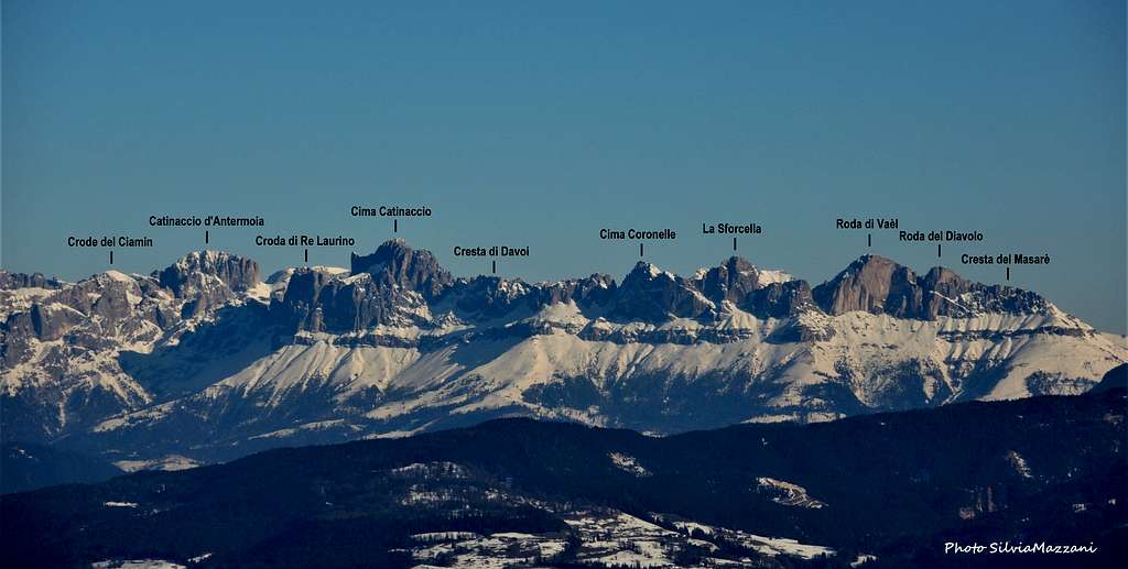
The Principe subgroup is a sharp chain about 1500 meters long which dominates the Conca del Principe and the Rifugio Bergamo (Grasleiten Hutte) with rocky walls. It's a small subgroup - uncrowded and not fully explored - consisting of only four peaks: the Cima di Fuori del Principe 2698 m, the Cima di Mezzo del Principe 2705 m, the Cima di Dentro del Principe 2672 m and the Torre del Principe 2568 m.
Il sottogruppo del Principe è una catena lunga circa 1500 metri che domina con le sue pareti rocciose la Conca del Principe e il Rifugio Bergamo (Grasleiten Hutte). Si tratta di un piccolo sottogruppo - poco frequentato e non del tutto esplorato, composto da sole quattro cime: la Cima di Fuori del Principe 2698 m, la Cima di Mezzo del Principe 2705 m, la Cima di Dentro del Principe 2672 m e la Torre del Principe 2568 m.
Molignon-Antermoia
This subgroup includes the highest summit of the whole group: the Catinaccio d'Antermoia 3004 m, the only mountain of the Catinaccio group to overcome the 3000m threshold. In the page Catinaccio d'Antermoia you can find complete info about it. In the subgroup there are few other peaks, all interesting, such as the Cògolo del Lago 2811 m and the Croda dei Cirmèi 2902 m.
Questo sottogruppo comprende la vetta più alta di tutto il Catinaccio: il Catinaccio d'Antermoia 3004 m, l'unica montagna del gruppo del Catinaccio a superare la soglia dei 3000 m. Nella pagina Catinaccio d'Antermoia si possono trovare informazioni complete a riguardo. Nel sottogruppo sono presenti poche altre vette, tutte interessanti, come il Cògolo del Lago 2811 m e la Croda dei Cirmèi 2902 m.
Larsec
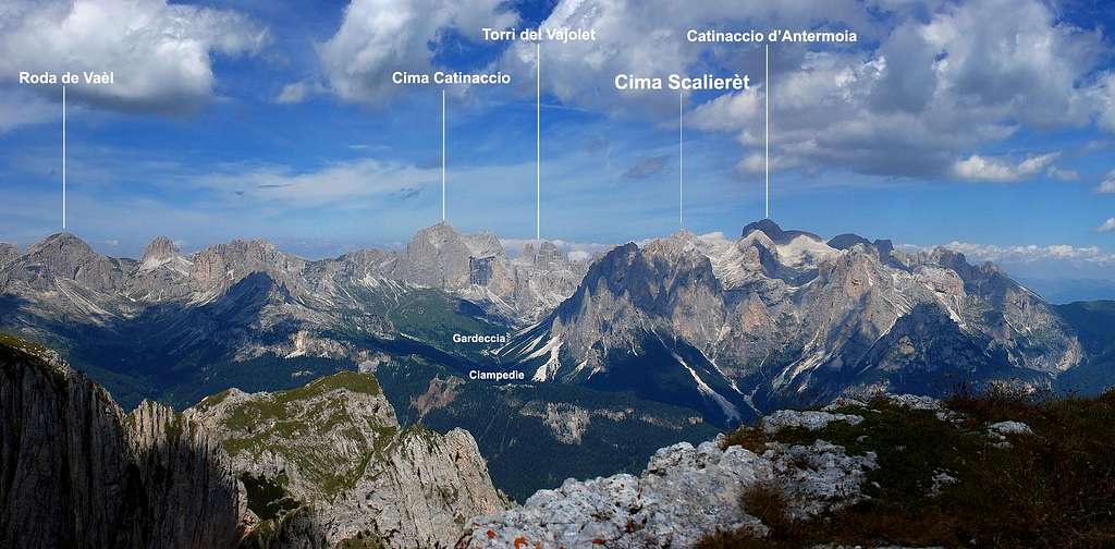
The Passo Antermoia 2710 m divides the Larsèc subgroup from the Molignon-Antermoia. The Larsèc, also famous with the name Dirupi di Larsèc, is a wild and secluded area including many summits and rock towers. The rock is not always fine, anyhow there are some good climbing routes and the advantage is that in this group, even in summer, you can find few people and stillness. Main summits: Cima Scalieret 2887 m - Cima Larsec 2891 m - Pala di Mezdì - Gran Cront 2778 m - Punta Scalpello - Pala della Ghiaccia.
From the climbing point of view, the most frequented summits in reason of the beauty of the rock and the proximity to Gardeccia are Campanile Gardeccia and Guglia del Rifugio.
The most comfortable points of support for climbing or walking in this area, both situated in the Gardeccia basin, are:
Rifugio Gardeccia 1949 m
Rifugio Stella Alpina
Il Passo Antermoia 2710 m divide il sottogruppo Larsèc dal Molignon-Antermoia. Il Larsèc, famoso anche con il nome Dirupi di Larsèc, è un'area selvaggia e appartata che comprende numerose cime e torri di dolomia. La roccia non è sempre buona, comunque ci sono alcune belle vie di arrampicata e il vantaggio è che in questo gruppo, anche d'estate, si trova poca gente e molta quiete. Cime principali: Cima Scalieret 2887 m - Cima Larsec 2891 m - Pala di Mezdì - Gran Cront 2778 m - Punta Scalpello - Pala della Ghiaccia
Dal punto di vista dell'arrampicata, le vette più frequentate per la bellezza della roccia e la vicinanza al Gardeccia sono il Campanile Gardeccia e la Guglia del Rifugio.
I punti di appoggio più comodi per l'arrampicata o le escursioni in zona, entrambi situati nella conca del Gardeccia, sono:
Rifugio Gardeccia 1949 m
Rifugio Stella Alpina
 |
 |
 |
 |
 |
Valbona
The Valbona subgroup includes some low frequented summits, as the Teste di Agnello 2682 m, the Crode del Ciamin 2759 m, the Piccola Valbona 2802 m and just to the west of Catinaccio d'Antermoia, divided from it by a valley, the Cima Grande di Valbona 2824 m, the main summit of this subgroup. On the NW edge of the Cima Orientale di Valbona (Valbona East summit) 2705 m there is the fine Dulfer route (D sup).
Il sottogruppo Valbona comprende alcune vette poco frequentate, come la Teste di Agnello 2682 m, le Crode del Ciamin 2759 m, la Piccola Valbona 2802 m e appena ad ovest del Catinaccio d'Antermoia, diviso da esso da una valle, la Cima Grande di Valbona 2824 m, vetta principale di questo sottogruppo. Sul margine NW della Cima Orientale di Valbona 2705 m si trova la bella via Dulfer (D sup).
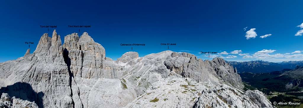
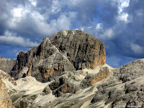
Catinaccio Centrale - Vajolet and Croda di Re Laurino
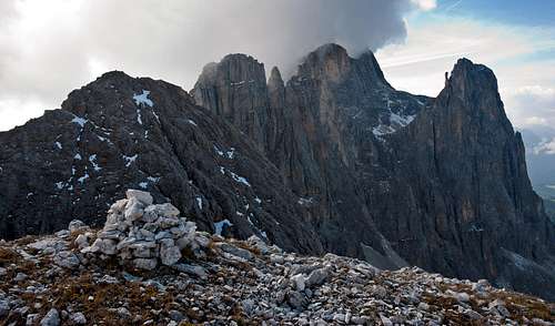
The central sector of the Catinaccio is the most famous and majestic part of the whole group. It is made up of two more or less parallel chains with a North-South trend, the central Catinaccio chain with the main Catinaccio summit and the Vajolet and Croda di Re Laurino chain.
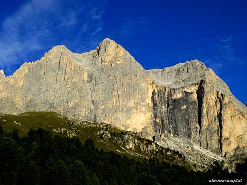
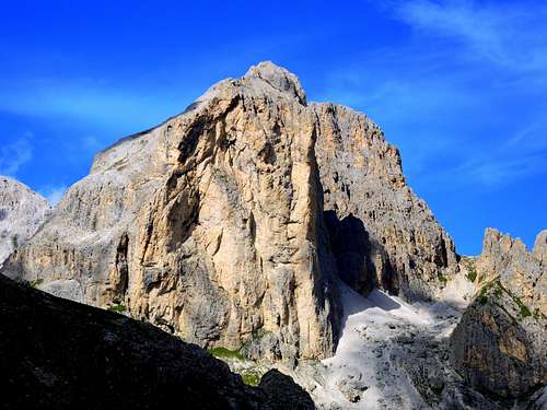
Catinaccio main summit 2981 m is the most important mountain of the whole group, its name comes from the two big basins ("catini" in Italian) in the upper part of the East wall. On this wall, about 700 m drop, there are many routes: the most classic, important and climbed is the Steger route (TD - very elegant). Many other routes get the summit across the Southern "catino". Some extreme routes, on the black wall, get the Northern "catino" (the largest one).
On the West side Catinaccio shows a short but wide wall which right end overlooks a large saddle that divides Catinaccio from Croda di Re Laurino (here the Passo Santner - 2741 m). In the proximity of this pass it starts the Normal route (II degree UIAA - not for hikers). Check here on SP the Catinaccio main page to get the complete description of the Normal route and an exhaustive list of the routes: Catinaccio/Rosengartenspitze.
At the right limit of the East wall a big cylindrical tower, the Punta Emma, has three very fine and classic routes often climbed : the Piaz route (TD inf), the Steger route (TD inf) and the Fedele route (D sup).
At the left limit of the East wall there is the Forcella Sud del Catinaccio 2680 m, located between the Catinaccio main summit and the Cresta di Davoi, an extended ridge along which several rocky peaks are aligned, among which the fine Punta Kafmann.
Il settore centrale del Catinaccio è la parte più famosa e maestosa di tutto il gruppo. È costituito da due catene più o meno parallele con andamento Nord-Sud, la catena centrale del Catinaccio con la cima principale del Catinaccio e la catena del Vajolet e della Croda di Re Laurino.
La cima principale del Catinaccio 2981 m è la montagna più importante dell'intero gruppo, il suo nome deriva dai due grandi bacini ("catini" in italiano) nella parte superiore della parete Est. Su questa parete, alta circa 700 m, sono presenti numerose vie di arrampicata:
la più classica, importante e frequentata è la via Steger (TD - molto elegante). Molte altre vie portano in vetta attraverso il "catino" meridionale. Alcune vie estreme, sulla parete nera, portano al "catino" settentrionale (il più grande).
Sul versante Ovest il Catinaccio presenta una breve ma ampia parete che, all'estremità destra, si affaccia su una grande sella che divide il Catinaccio dalla Croda di Re Laurino (il Passo Santner - 2741 m). In prossimità di questo passo inizia la Via Normale (II grado UIAA - non per escursionisti). Consulta qui sulla SP la pagina principale del Catinaccio per avere la descrizione completa della Via Normale e un elenco esaustivo delle vie: Catinaccio/Rosengartenspitze.
Al limite destro della parete Est si trova una grande torre a forma cilindrica, la Punta Emma, che presenta tre vie molto belle e classiche spesso salite: la via Piaz (TD inf), la via Steger (TD inf) e la via Fedele (D sup). Al limite sinistro della parete Est si trova la Forcella Sud del Catinaccio 2680 m, posta tra la vetta principale del Catinaccio e la Cresta di Davoi, un'estesa cresta lungo la quale si allineano diverse cime rocciose, tra cui la bella Punta Kafmann.
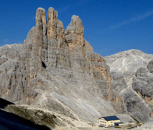
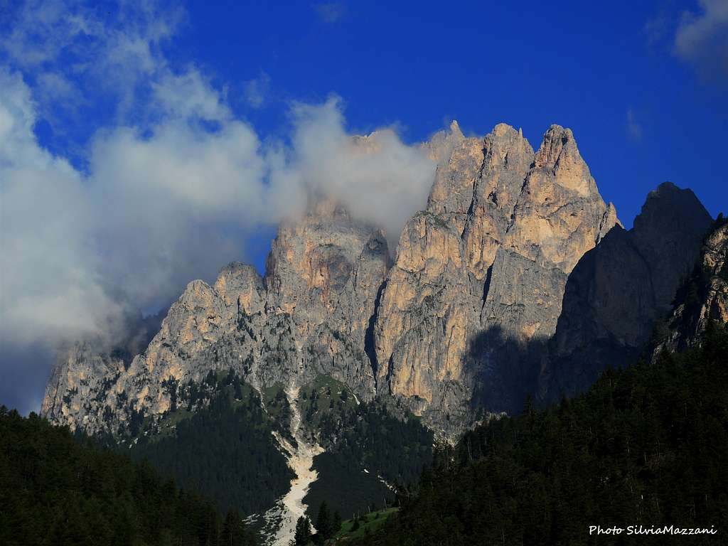
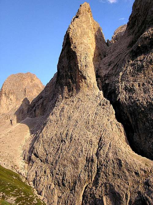
In the Vajolet and Croda di Re Laurino chain we see the Torri Minori del Vajolet, the Torri Settentrionali del Vajolet and the world-renowned tryad of Torri del Vaiolet including Torre Winkler 2800 m to the right, Torre Stabeler 2805 m in the middle and Torre Delago 2790 m to the left, whose celebrated image constitutes a formidable icon of the Catinaccio group.
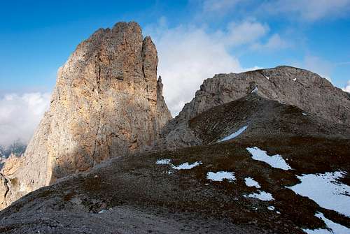
At the end of the chain is situated the Croda di Re Laurino 2813 m, which East wall is rising for about 100 m over the Passo Santner. On the opposite side (West) it drops with a majestic fine wall, that is famous for the "Enrosadira" (at sunset the wall gets a brilliant red colour).
Nella catena del Vajolet e della Croda di Re Laurino troviamo le Torri Minori del Vajolet, le Torri Settentrionali del Vajolet e la rinomata triade delle Torri del Vaiolet, tra cui Torre Winkler 2800 m a destra, Torre Stabeler 2805 m al centro e Torre Delago 2790 m a sinistra, la cui celebre immagine costituisce una formidabile icona del gruppo del Catinaccio.
Al termine della catena si trova la Croda di Re Laurino 2813 m, la cui parete Est si innalza per circa 100 m oltre il Passo Santner. Sul versante opposto (Ovest) scende con una maestosa e bella parete, famosa per il fenomeno "Enrosadira" (al tramonto la parete assume un colore rosso brillante).
A very fine hiking turns round the Catinaccio subgroup :
starting from Gardeccia - passo Coronelle - passo Santner - Vajolet valley to come back to Gardeccia - it takes few hours and has only one point that can require attention if some snow or ice is still there (fixed ropes).
The best huts to stay for climbs and walks on Catinaccio East wall here are located in the Eastern side of the group :
- Rifugio Gardeccia 1949 m
- Rifugio Stella Alpina 1950 m
Other important huts to climb or hike here :
- Rifugio Re Alberto I, at foot of the Vajolet towers - 2620 m
- Rifugio Vajolet - 2243 m
- Rifugio Preuss 2243 m
- Rifugio Passo Principe - 2600 m
- Rifugio Passo Santner 2741 m
On the Western side of the chain:
Rifugio Fronza alle Coronelle 2337 m
Un'escursione molto bella compie il periplo del sottogruppo del Catinaccio Centrale: partendo da Gardeccia - passo Coronelle - passo Santner - val Vajolet per tornare a Gardeccia. E' un anello che richiede poche ore e presenta un solo punto che può richiedere attenzione se ancora è presente un po 'di neve o ghiaccio (corde fisse).
I migliori rifugi dove pernottare per effettuare ascensioni sulla parete est del Catinaccio ed escursioni si trovano nel versante orientale del gruppo:
- Rifugio Gardeccia 1949 m
- Rifugio Stella Alpina 1950 m
Altri rifugi importanti per scalate o escursioni nel Catinaccio centrale:
- Rifugio Re Alberto I, ai piedi delle Torri del Vajolet - 2620 m
- Rifugio Vajolet - 2243 m
- Rifugio Preuss 2243 m
- Rifugio Passo Principe - 2600 m
- Rifugio Passo Santner 2741 m
Sul versante occidentale del gruppo:
- Rifugio Fronza alle Coronelle 2337 m
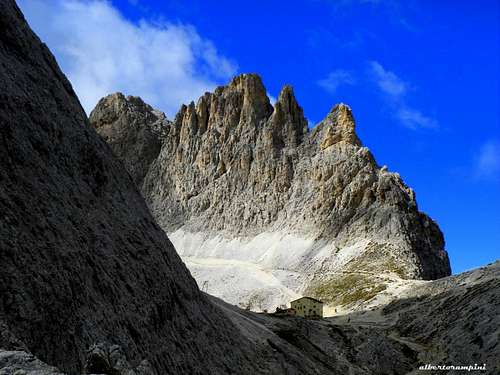
Mugoni and Coronelle
It's an important but little known horseshoe-shaped subgroup, containing the Gran Busa di Vaèl, including some summits.
- Coronelle 2794 m is a long ridge connecting the Catinaccio with the Mugoni, no climbing importance but very fine for hiking.
- Mugoni 2757 m, with various summits. The Cima sud dei Mugoni is a majestic tower with the famous difficult Vinatzer route, often climbed.
- Cigolade 2482 m with various summits.
The best huts to climb here :
Rifugio Gardeccia 1949 m
Rifugio Stella Alpina 1950 m
Rifugio Fronza alle Coronelle 2314 m
Si tratta di un sottogruppo a forma di ferro di cavallo, importante ma poco conosciuto, comprendente la Gran Busa di Vaèl e alcune vette.
- Coronelle 2794 m è una lunga cresta che collega il Catinaccio con il Mugoni, nessuna importanza alpinistica ma molto bella per l'escursionismo.
- Mugoni 2757 m, con varie vette. La Cima sud dei Mugoni è una torre maestosa con la famosa e difficile via Vinatzer, spesso scalata.
- Cigolade 2482 m con varie vette.
I migliori punti di appoggio per escursioni e scalate sono:
Rifugio Gardeccia 1949 m
Rifugio Stella Alpina 1950 m
Rifugio Fronza alle Coronelle 2314 m
Roda di Vael
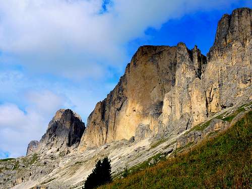
The Roda di Vaèl chain is formed by imposing and famous peaks, such as the celebrated Roda di Vaèl (Rotwand) 2806 m and its majestic red wall, on which it runs the Buhl route, a spectacular route always adressed to be climbed by the skilled climbers. Many other routes on this wall, all very difficult, some extreme.
Other well known summits are the magnificent Sforcella 2791 m, the Roda del Diavolo 2723 m, the Croz di Santa Giuliana 2670 m and the Torri del Masarè.
Useful huts for climbing here:
- Rif. Roda di Vaèl 2283 m
- Rif. Pederiva 2283 m
- Rif. Paolina 2127 m
La catena della Roda di Vaèl è formata da vette imponenti e famose, come la celebre Roda di Vaèl (Rotwand) 2806 m con la sua maestosa parete rossa, sulla quale si snoda la via Buhl, una via spettacolare destinata a esperti scalatori. Troviamo molte altre vie su questa parete, tutte molto difficili, alcune estreme.
Altre vette note sono la magnifica Sforcella 2791 m, la Roda del Diavolo 2723 m, il Croz di Santa Giuliana 2670 m e le Torri del Masarè.
Rifugi utili per l'arrampicata qui:
- Rif. Roda di Vaèl 2283 m
- Rif. Pederiva 2283 m
- Rif. Paolina 2127 m

Red Tape
No particular restrictions in climbing and hiking. The road starting from Pera di Fassa to Gardeccia is open to the private cars as far as the small hamlet of Soial. Limited parking possibilities. Private cars beyond Soial are not allowed.
Nessuna restrizione particolare per l'arrampicata e l'escursionismo. La strada da Pera di Fassa a Gardeccia è aperta alle auto private fino alla piccola frazione di Soial. Possibilità di parcheggio limitate. Le auto private oltre Soial non sono ammesse.
Natural Parks
Cima Catinaccio is located inside the Natural Park Sciliar-Catinaccio and Latemar. This area, shared between the provinces of Bolzano and Trento, is one of the nine mountain systems of the Dolomites acknowledged as UNESCO World Heritage Site. It is one of the most important systems worldwide for the study of the stratigraphy of the Triassic, in reason of the plenty of fossils on Alpe di Siusi, the relationship between carbonate and volcanic sediments, and the fact that the outcrops are easily accessible. Catinaccio, with the stunning Vajolet Towers, forms a series of peaks and sharp needles showing the movement of an island which sank into the sea 240 million years ago. More info about Dolomiti Unesco World Heritage here:
Dolomites living mountains
Dolomiti Unesco
Cima Catinaccio si trova all'interno del Parco Naturale Sciliar-Catinaccio e Latemar. Quest'area, condivisa tra le province di Bolzano e Trento, è uno dei nove sistemi montuosi delle Dolomiti riconosciuti Patrimonio dell'Umanità dall'UNESCO. È uno dei sistemi più importanti al mondo per lo studio della stratigrafia del Triassico, in ragione dell'abbondanza di fossili sull'Alpe di Siusi, del rapporto tra carbonato e sedimenti vulcanici e del fatto che gli affioramenti sono facilmente accessibili. Il Catinaccio, con le meravigliose Torri del Vajolet, forma una serie di picchi e aghi aguzzi che mostrano il movimento di un'isola affondata nel mare 240 milioni di anni fa. Maggiori informazioni sulle Dolomiti Patrimonio Unesco qui:
Dolomites living mountains
Dolomiti Unesco
When To Climb
Hiking and climbing: Summertime (from June to the end of September)
Ski-mountaneering (from Gardeccia toward northern side, passo Principe): February and March
Escursionismo e arrampicata: Estate (da giugno a fine settembre)
Scialpinismo (da Gardeccia verso nord, passo Principe): febbraio e marzo
 |
Camping, huts and other kind of accomodation
| Rifugio/Hut | Height | Open | Tel. |
| Re Alberto I / Gartlhütte | 2620m | mid June - end Sept. | +39 0462 763428 |
| Passo Santner / Santner Pass Hütte | 2734m | not available | +39 0471 642230 |
| Aleardo Fronza / Rosengartenhütte | 2337m | mid June - mid Sept. | +39 0462 764461 |
| Vajolet | 2243m | mid June - mid Sept. | +39 0462 763292 |
| Preuss | 2243m | mid June - end Sept. | +39 0462 764847 |
| Gardeccia | 1963m | mid June - mid Oct. | +39 0462 763152 |
| Ciampedie | 1998m | beg. June - mid Oct. | +39 0462 764432 |
| Negritella | 1990m | mid June - mid Sept. | +39 0462 764097 |
| Stella Alpina | 1963m | June - Oct. | +39 0462 764388 |
| Roda di Vael / Rotwandhütte | 2280m | mid June - mid Sept. | +39 0462 764450 |
| Catinaccio | 1960m | end May - end Sept. | +39 0462 766987 |
| Passo Principe / Grasleitenpasshütte | 2599m | end June - end Sept. | +39 0462 764244 |
| Bergamo al Principe / Grasleitenhütte | 1887m | not available | +39 0471 642103 |
| Antermoia | 2476m | mid June - mid Sept. | +39 0462 750480 |

|

|

|

|
Val di Fassa offers many very confortable campsites, as well as hotels, B&Bs and apartments
La Val di Fassa offre molti campeggi molto confortevoli, ma anche hotel, B&B e appartamenti
Meteo
Meteo Trentino
Dolomiti Meteo - Trentino
Meteo Bolzano
Guidebooks and Maps
Up-to-date climbing guidebooks are:
Le guide di arrampicata più aggiornate sono:
"Arrampicare sul Catinaccio e dintorni" by Mauro Bernardi, Ed. Athesia, 2013
“La nuova guida del Catinaccio” by Antonio Bernard, Ed. Mediterranee, 2008 – A wide selection of the Catinaccio group climbing routes
"Arrampicare Dolomiti Nord-Occidentali
"IV grado Dolomiti Occidentali" vol. I by Emiliano Zorzi, ed. Idea Montagna 2011
"IV grado Dolomiti Occidentali" vol. II by Emiliano Zorzi, ed. Idea Montagna

|

|

|

|

|
Choosing among all the books regarding Catinaccio group, for information we mention the old classic but long-lost guide:
Scegliendo tra tutti i libri riguardanti il gruppo del Catinaccio, per informazione citiamo la vecchia guida classica ormai introvabile:
"Sassolungo, Catinaccio, Latemar", Arturo Tanesini - Guida dei Monti d'Italia, ed. CAI-TCI (1953) and also:
“Catinaccio” by Dante Colli and Gino Battisti - Tamari Editori in Bologna, 1984
A fine hiking guidebook:
Una bella guida escursionistica:
"Gruppo del Catinaccio" by Luca Visentini, Ed. Athesia (1979) also in German with the title "Rosengarten"
Another updated and excellent guidebook describing all the hikes and the Normal routes to the hundreds of summits of the whole range, with a lot of pictures, topos and very accurate maps is
Un'altra guida aggiornata ed eccellente che descrive tutte le escursioni e le vie normali alle centinaia di cime dell'intera catena, con molte immagini, topos e mappe molto accurate è
"Gruppo del Catinaccio" by Andrea Gabrieli, Luca Visentini Editore (2010)
- Maps
Rosengarten-Catinaccio Latemar - 1:25.000 sheet - Compass
Val di Fassa e Dolomiti Fassane - 1:25.000 - sheet 06 - Tabacco
Sciliar/Schlern Catinaccio/Rosengarten Latemar-Regglberg - 1:25.000 - sheet 029 - Tabacco