
-
 3004 Hits
-
 72.08% Score
-
 2 Votes
|
|
Custom Object |
|---|---|
|
|
43.59574°N / 110.86642°W |
|
|
workshop II |
How Rare is it?
=========================================
Here
=========================================
=============================================
==================================================
The Sentinel==============
Ojai Raptor Center
===========================
============================
=========================================
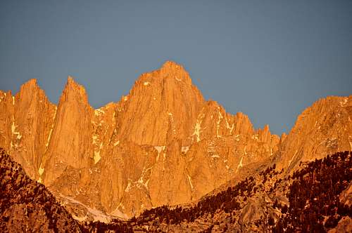
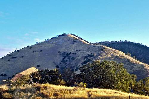
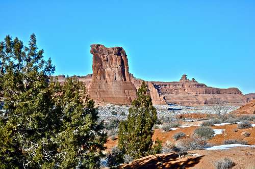
Looking at Grass Mountain in Los Padres National Forest from a distance, the west Ridge looks quite tame. But when you actually hike the trail, your endurance and resolve are thoroughly tested. There are no rocky sections, nor are there any switch backs. In short, West Ridge Grass Mountain is no walk in the park. After the initial three quarters of a mile, the steepness of the trail becomes unrelenting. You gain over 2000 feet in only 1.2 miles. Since most of this mountain is covered by chaparral, your choice of routes are limited. The West Ridge, oddly enough stays free of chaparral and is the most reasonable route to the summit. Be prepared for a difficult hike with great views. During the summer months the creeks are bone dry and the area is quite hot. Carry three quarts of water. The return can be confusing. So, carry a compass or a GPS and make notes on the way up.
How to get to the trailhead and Red Tape:
![Sunrise grazing the east ridge of Grass Mountain]()
![Hiking Permits Box]()
From the city of Santa Barbara on the southern California coastline, take Highway 154 and drive for seven miles to San Marcos Pass. Drop down the back side and drive 14.6 miles to the junction with Figueroa Mountain Road at the town of Los Olivos. Take a right here and drive five miles to Midland School.
Grass Mountain trail is located within the Midland School property. You need to get a permit to enter the area.
Drive into the school and find the box marked "Hiking permits." You need to fill out a permit form, leave a copy in the box and carry one with yourself. Get back onto Figueroa Mountain Road again and drive another two miles up the road. The road makes a sharp turn to the right and crosses a cattle guard. Shortly after the cattle guard there is a gate. You can park here, but not too close to the gate. The trailhead is right across from the gate. There is also a large pullout just before the sharp turn on the road and the cattle guard.
The Hike:
1- Start your hike at this unnamed trailhead at an elevation of 1329 feet. GPS reading, 34.74171 -120.062089
2- Heading northwest and keeping the creek to your left will bring you to the first gate. Climb over the gate and continue on the trail keeping the creek to your left.
3- After hiking through a meadow climb over a second gate. 34.7444 -120.0588
4- You will come to a three-way fork on the trail. Take the left one. 34.7459 -120.0568
5- Cross the creek over medium size boulders. 34.7465 -120.0560
6- Another fork on the trail is reached. Take the right one. 34.7472 -120.0555
7- Cross another creek and bear left. Hike up a meadow to the base of the lower ridge. 34.7551 -120.0525
8- Follow the trail that continues on the south side of the west ridge. After a short gravel covered hillside reach a dead tree near the broad summit of Grass Mountain. A clump of trees will provide a welcome shade.
34.76248 -120.041857
Summit elevation, 3685 feet. Total elevation gain 2356 feet. Total one way distance 2.25 miles.
The Ghost is an interesting area in that it's well-hidden in plain sight. Leaving the Movie Flat Road, you find yourself in a maze of narrow dirt roads, only one of which leads to this area. Upon entering The Ghost area you are struck by the number and complexity of rock formations and rock towers. Most of these rock towers are very difficult or, in many cases, impossible to access. Yet, a number of formations close to the road are developed for sport climbing.
Although still not exactly straight forward to approach, Schmaltz Rock is one of the first formations up this rocky canyon. The base is strewn with large boulders making the approach confusing and nearly impossible. In my humble opinion, the easiest approach seems to be from the base of Nice Tower. Considering the moderate nature of the routes on Schmaltz, this formation could have been a lot more popular than it is. Days that you see crowds waiting for their turn on the base of Tall Wall or Hoodgie Wall, not far from this formation, you would be hard-pressed to find two climbers on Schmaltz. For some climbers, that may be reason enough to give this rock a chance.
As mentioned before, the routes are all moderate in difficulty rating, between 5.7 to 10b, with majority falling in the 5.9 range. The most prominent feature on this rock, easily seen from the road, is a wide crack running up the middle of the rock and requiring some very large protection. This route, Schmaltie, named after the name of the formation. There is another crack on the left side of the formation and because of the difficulty in approaching it is not included in the page. The remaining routes are bolted and you will find adequate anchors on top to rappel off of.
=========================
==========================
From the town of Lone Pine, California, on Highway 395 take Whitney Portal Road at the only traffic light in town. Drive 2.7 miles west on this road to intersect Movie Road. Turn right onto the Movie Road. This road is paved for a short distance then it turns into a dirt road. The first dirt road to intersect the Movie Road heads for Shark's Fin. Drive about a mile to where Movie Road makes a sweeping turn to the right. Just before reaching this turn you will see a dirt road intersecting from the left. Take this dirt road. Drive a short distance to another dirt road from the left. Go left on this one as well. If you end up by Tall Wall, The Western Wall and Nut Towers you have not taken the correct left turn on your way to the Ghosts area. Looking from the Movie Road, the Ghosts area is to the left of the Tall Wall and Western Wall area. You need to back track and take the correct left turn. There is a large parking area here and it's almost surrounded by rack formations. Looking across the wash, Elephant Rock is obvious. Please use the trails marked by small stones and rocks to reach to formations. Drop down the marked path to the base of Elephant Rock and go left to reach Nice Tower. Crawl under, scramble up and over good size boulders to reach the base. Looking in the direction of Owens Valley, east, you will see Schmaltz from here. Walk around, scramble over and under more boulders to reach the base.
The most noticeable feature on this formation is a dizzying overhang not far from the ground. Thankfully, there are cracks and handholds making it possible for one to climb the route. In 1979 this feature did not get past the Joshua Tree pioneer, Herb Laeger, when he made the first ascent of this route making it the first route to be climbed on this part of the buttress. He named the route "Head Over Heals" and rated it at 10a. Even to this day, more than thirty years later, this route remains the most popular and intriguing climb on this part of the buttress. During the subsequent few years, several other routes as well as a few variations to the original Head Over Heals were established. On a day when the middle part of Hemingway Buttress is crowded with climbers waiting for their turn, it pays to pay a visit to to the right side.
=================
======================
![Hemingway Buttress]()
Hemingway Buttress at sunriseFrom the west enterance to Joshua Tree National Park, drive about eight miles to a large paved parking area with a bathroom. This parking is about two miles past Quail Springs parking, and it has its own sign, “Hemimngway” indicating that you have arrived. Looking toward the west you will see the elongated Hemingway Buttress at a few minutes walking distance.
There are at least two trails heading out toward different nearby formations and an Access Fund trail leading toward the main Hemingway Buttress. Head for the right side of the main buttress. You will find two pinnacle looking formations. The right one, just to the left of a prominent gully, is the subject of this page.
Arlington Peak is located to the southeast of Cathedral Peak and to the south of La Cumbre Peak in the Santa Ynez Mountains of Los Padres National Forest, California.
For many years this beautiful peak did not have a name of its own. Everyone I knew referred to it as Cathedral Peak, and the rock formation to its northwest as Cathedral Rock. At some point in time Google Map changed the name of Cathedral Rock to Cathedral Peak and out peak was left without a name. I am not sure who or at what point in time the name of Arlington Peak was chosen for our beautiful little mountain. Even to this day, the printed maps don't show a name for Arlington Peak.
Even though Arlington Peak is by no means the highest point in the santa Ynez Mountains, it is visible and distinguishable from miles away. Its pyramidal shape, its rocky south face and its steep east ridge make this mountain stand out amongst the background hillsides. After the forest fires of May of 2009, the true majesty of Arlington Peak became obvious. The rocky formations that were covered by sage brush displayed their true size. Someone has commented "This mountain looks like a woman who has taken off her cloths."
Climbing Arlington Peak is not just another hike up a dirt trail. You are following a ridgeline that is open and scenic. You find yourself scrambling on, over and around rocks and boulders. The views from the top are truly breathtaking. Since this mountain sits in front of the main Santa Ynez ridgeline, the summit views are much greater in perspective. You get an uninterrupted views of the California coastline in both direction, southeast and west. The views of Santa Barbara Channel Islands against the blue Pacific Ocean are something to behold. Closer up, you get the best view of Mission Ridge and Tunnel Trail and how exactly it snakes its way all the way up to Camino Cielo Road and La Cumbre Peak.
How to get to the trailhead:
From US Highway 101 in Santa Barbara take the Mission Street off ramp and turn right at the light. Continue on Mission street passing in front of the mission building to a stop sign at the intersection with Foothill Road. Turn right onto Foothill Road and left onto Tunnel Road. You will come to a fork. Take the left fork and drive all the way to the end. You can park on the right hand side of the road within the white lines. Additional parking may be found before the end of the road. Please do not park in the side streets. They are all private roads.
The hike:
The hike begins the same as the trail for Inspiration Point. After crossing Mission Creek on rocks, you will see another trail to the right of Inspiration Point trail. This trail is steep and parallels Mission Creek for about quarter of a mile then climbs steeply to the west, left. Follow this trail to the foot of the east ridge. Follow the east ridge that climbs over and around countless boulders and rock formations to the rocky summit of Arlington Peak. The true summit is just past a large peace sign painted on a rock with white paint and visible from the top of the false summit.
Starting off the ground, the opening moves are awkward and technical. In fact, this is the crux of the route and it used to be rated only 5.9. Through the years of people trying this initial section, the dead rubber from people's shoes has made the rock slick and difficult. After the initial moves, you end up inside a semi pod on the base of a featureless body size chimney/groove. You need to have nerves of steel and technical ability to get high enough to place your first piece of protection. The route continues up the same groove slowly turning into a face. This face culminates onto a big ledge. Go a little left to find the anchor. This ledge is the official end of Waterchute. But, since you are here, you might as well climb to the top. The easiest option is climbing the second pitch of Mike's Book. Easy chimneys and cracks lead to the top of the rock where you will find another anchor.
Descent: You can rap down to the ledge with a single rope, then another rap to the base of the route.
Essential Equipment: One 60 meter rope, standard rack, slings, helmet.
================
From the western entrance to Joshua Tree National Park drive on Park Boulevard, formerly known as Quail Springs Road, for about nine miles to a major rock formation called “Intersection Rock.” Intersection Rock is a major landmark on the north side of Quail Springs Road with ample parking for visitors and climbers alike. This rock, true to its name, sit at the cross roads to “Hidden Valley Campground”, Barker Dam Road and the road to “Day use and picnic” area.
======================
DXM Wall is the name of a rock formation in the The Alabama Hills on the outskirts of Mount Whitney in the Sierra Nevada Range., California.
DXM Wall is the last major formation in an area known as The Ghost. The entire Ghost area is rich in formations and rock towers, and I have no doubt that in the future more areas up this rocky canyon will be developed. DXM Wall is located a short distance to the northwest of Elephant Rock & The leaning Tower of Pizza, and it's clearly visible from the parking area. Unlike many formation in The Alabama Hills that you have a wide and flat base, DXM Wall has a rocky base and not particularly inviting for large groups. That fact alone may be the reason for lack popularity that this formation well deserves. The most distinguishing features of this wall are two wide cracks that run parallel to each other separating the formation into two sections, right and left. The larger concentration of the routes are located on the left wall, hence a bit more problematic getting to bases of.
The most sought after route on the left wall is a beautiful crack/double crack that was originally done using standard gear for protection. This route is named Dextromethorphan, rated 5.9. At some point in time, this route was bolted and it's rating was down graded to 5.8. In either case, using gear or clipping bolts next the crack for protection, this route is definitely a worthy of doing for a visitor. A set of anchor bolts just before the angle of the rock eases off, will greet your arrival. The right side of DXM Wall also sports one of the most popular routes on this formation. This route is called Ghost Dance, rated 5.8 and is protected by bolts. Although the old guide book by Michael Strassman calls this route a great beginner lead, I know a number of climbers, myself included, that were forced to pay close attention to every move to get up this route. On top of Ghost Dance, as well as most of the routes on DXM Wall, you will find double-bolt anchors. The best way to preserve and lengthen the life of these critical anchors is rappel off of them and not using them for lowering off. In addition, please use your own quick draws for top roping.
=============================
==============================
From the town of Lone Pine, California, on Highway 395 take Whitney Portal Road at the only traffic light in town. Drive 2.7 miles west on this road to intersect Move Road. Turn right onto the Movie Road. This road is paved for a short distance then it turns into a dirt road. The first dirt road to intersect the Movie Road heads for Shark's Fin. Drive about a mile to where Movie Road makes a sweeping turn to the right. Just before reaching this turn you will see a dirt road intersecting from the left. Take this dirt road. Drive a short distance to another dirt road from the left. Go left on this one as well. If you end up by Tall Wall, The Western Wall and Nut Towers you have not taken the correct left turn on your way to the Ghosts area. Looking from the Movie Road, the Ghosts area is to the left of the Tall Wall and Western Wall area. You need to back track and take the correct left turn. There is a large parking area here and it's almost surrounded by rack formations. Looking across the wash, Elephant Rock is obvious. Please use the trails marked by small stones and rocks to reach to formations. Drop down the marked path to the base of Elephant Rock and go right past The Leaning Tower of Pizza. Then, scramble around and over some boulders to get to the base.
============================================
![Mount Whitney]()
Mount WhitneyAlthough many parties camp within the parking areas of the Alabama Hills, this practice is highly discouraged. The area suffers from mismanaged campsites and blackened caves. There are two campgrounds very close to the Alabama Hills. Lone Pine Campground is further up the road on Whitney Portal Road, and Tuttle Creek Campground is within a few miles up Horseshoe Meadow Road.
If you don't mind driving another fifty miles, there are many campgrounds along Bishop Creek just to the west of Bishop. There are also many places in The Buttermilks area that are close to a creek that are suitable for camping. Please do not camp in The Buttermilks bouldering area. That area is very crowded and is suffering from the impact unregulated camping has caused.
The following links should help finding a good campsite
Horton Creek Campground
Rock Creek Canyon
Inyo National Forest
Bishop Creek and vicinity camping
Most visitors to Joshua Tree enter the park from the western entrance. The first few miles of the drive is typical Joshua Tree landscape. If the visitor is non climber, they begin to enjoy the park immediately. But, for the first time to Joshua Tree climber things are quite different. They cannot wait to get to the biggest and the most famous formations such as Intersection Rock and The Old Woman. In the process, they miss a great number of smaller, unimportant-looking formations along the road. Lizard's Hangout qualifies as one such case.
Lizard's Hangout is a close neighbor to Roadside Rock, but with several great advantages. In contrast to Roadside Rock, it sits a few hundred feet off the main road, it faces away from the traffic and it sports several great routes. Best of all, it stays sunny all day long making it an ideal place to hangout on a cold winter day.
============================
It is surprising that this small formation, about thirty feet high, was mostly overlooked by the climbing pioneers to Joshua Tree for decades. The most inviting cracks in the middle of the face didn't get led until the late 1980s. Nowadays, however, Lizard's Hangout gets regular visits by climbers looking for several moderate crack routes very close together. Many parties don't bother leading these short pitches and they opt for top-roping the routes. It is very easy to scramble to the top from the backside and find many cracks and features for setting up anchors. In addition to the cracks and the face routes, Lizard's Hangout offers a number of traverses and boulder problems that can be found to the left of the south face. This is an enjoyable area to get a little workout if you are looking for an easy day not too far from the road.
To get to Lizard's Hangout, drive 7.1 miles from the west entrance to Joshua Tree National Park. This rock formation is just before you reach Roadside Rock and “Lost Horse Road.” You can park in a small pullout by the road or park by the bathrooms on Lost Horse Road and walk back about 250 yards to the rock. If you go as far as Hemingway Buttress parking, you have gone too far.
================================
------------
Dike Route ----------by Asteel
=================================
==============================================
===============================================
========================================
=========================================
Here
=========================================
=============================================
======================================
 |  |
==================================================
The Sentinel==============
Ojai Raptor Center
===========================
 |  |  |
============================
 |
=========================================
Looking at Grass Mountain in Los Padres National Forest from a distance, the west Ridge looks quite tame. But when you actually hike the trail, your endurance and resolve are thoroughly tested. There are no rocky sections, nor are there any switch backs. In short, West Ridge Grass Mountain is no walk in the park. After the initial three quarters of a mile, the steepness of the trail becomes unrelenting. You gain over 2000 feet in only 1.2 miles. Since most of this mountain is covered by chaparral, your choice of routes are limited. The West Ridge, oddly enough stays free of chaparral and is the most reasonable route to the summit. Be prepared for a difficult hike with great views. During the summer months the creeks are bone dry and the area is quite hot. Carry three quarts of water. The return can be confusing. So, carry a compass or a GPS and make notes on the way up.
How to get to the trailhead and Red Tape:

Grass Mountain trail is located within the Midland School property. You need to get a permit to enter the area.
Drive into the school and find the box marked "Hiking permits." You need to fill out a permit form, leave a copy in the box and carry one with yourself. Get back onto Figueroa Mountain Road again and drive another two miles up the road. The road makes a sharp turn to the right and crosses a cattle guard. Shortly after the cattle guard there is a gate. You can park here, but not too close to the gate. The trailhead is right across from the gate. There is also a large pullout just before the sharp turn on the road and the cattle guard.
The Hike:
1- Start your hike at this unnamed trailhead at an elevation of 1329 feet. GPS reading, 34.74171 -120.062089
2- Heading northwest and keeping the creek to your left will bring you to the first gate. Climb over the gate and continue on the trail keeping the creek to your left.
3- After hiking through a meadow climb over a second gate. 34.7444 -120.0588
4- You will come to a three-way fork on the trail. Take the left one. 34.7459 -120.0568
5- Cross the creek over medium size boulders. 34.7465 -120.0560
6- Another fork on the trail is reached. Take the right one. 34.7472 -120.0555
7- Cross another creek and bear left. Hike up a meadow to the base of the lower ridge. 34.7551 -120.0525
8- Follow the trail that continues on the south side of the west ridge. After a short gravel covered hillside reach a dead tree near the broad summit of Grass Mountain. A clump of trees will provide a welcome shade.
34.76248 -120.041857
Summit elevation, 3685 feet. Total elevation gain 2356 feet. Total one way distance 2.25 miles.
Schmaltz Rock
The Schmaltz is the name of a rock formation in the Ghost area of the The Alabama Hills on the outskirts of Mount Whitney in the Sierra Nevada Range., California.The Ghost is an interesting area in that it's well-hidden in plain sight. Leaving the Movie Flat Road, you find yourself in a maze of narrow dirt roads, only one of which leads to this area. Upon entering The Ghost area you are struck by the number and complexity of rock formations and rock towers. Most of these rock towers are very difficult or, in many cases, impossible to access. Yet, a number of formations close to the road are developed for sport climbing.
Although still not exactly straight forward to approach, Schmaltz Rock is one of the first formations up this rocky canyon. The base is strewn with large boulders making the approach confusing and nearly impossible. In my humble opinion, the easiest approach seems to be from the base of Nice Tower. Considering the moderate nature of the routes on Schmaltz, this formation could have been a lot more popular than it is. Days that you see crowds waiting for their turn on the base of Tall Wall or Hoodgie Wall, not far from this formation, you would be hard-pressed to find two climbers on Schmaltz. For some climbers, that may be reason enough to give this rock a chance.
As mentioned before, the routes are all moderate in difficulty rating, between 5.7 to 10b, with majority falling in the 5.9 range. The most prominent feature on this rock, easily seen from the road, is a wide crack running up the middle of the rock and requiring some very large protection. This route, Schmaltie, named after the name of the formation. There is another crack on the left side of the formation and because of the difficulty in approaching it is not included in the page. The remaining routes are bolted and you will find adequate anchors on top to rappel off of.
=========================
| Select Routes of Schmaltz Rock | |
| A | Schmendrick, 5.9, Bolts, anchor |
| B | Schmaltz, 10b, bolts, anchor |
| C | Schmaltzie, wide crack, wide pro, anchor |
| D | Schmuck, 5.9, bolts, anchor |
| E | Schmear, 5.8, bolts, anchor |
==========================
From the town of Lone Pine, California, on Highway 395 take Whitney Portal Road at the only traffic light in town. Drive 2.7 miles west on this road to intersect Movie Road. Turn right onto the Movie Road. This road is paved for a short distance then it turns into a dirt road. The first dirt road to intersect the Movie Road heads for Shark's Fin. Drive about a mile to where Movie Road makes a sweeping turn to the right. Just before reaching this turn you will see a dirt road intersecting from the left. Take this dirt road. Drive a short distance to another dirt road from the left. Go left on this one as well. If you end up by Tall Wall, The Western Wall and Nut Towers you have not taken the correct left turn on your way to the Ghosts area. Looking from the Movie Road, the Ghosts area is to the left of the Tall Wall and Western Wall area. You need to back track and take the correct left turn. There is a large parking area here and it's almost surrounded by rack formations. Looking across the wash, Elephant Rock is obvious. Please use the trails marked by small stones and rocks to reach to formations. Drop down the marked path to the base of Elephant Rock and go left to reach Nice Tower. Crawl under, scramble up and over good size boulders to reach the base. Looking in the direction of Owens Valley, east, you will see Schmaltz from here. Walk around, scramble over and under more boulders to reach the base.
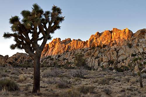
Hemingway Buttress, Right Side
Hemingway Buttress is one of the longest formations in Joshua Tree National Park. This formation embodies a large variety of routes the most popular of which are located on the left and middle sections of it. The right side of Hemingway Buttress, however, has its own share of routes. In contrast to the rest of this buttress, the right side is made of pinnacle looking formations. The right pinnacle, the subject of this page, is located just to the left of the descent gully for the routes you find on the main part of the buttress. The descent for the right side formations are done by rappelling from the bolt anchors on a ledge on top of Head Over Heals route.The most noticeable feature on this formation is a dizzying overhang not far from the ground. Thankfully, there are cracks and handholds making it possible for one to climb the route. In 1979 this feature did not get past the Joshua Tree pioneer, Herb Laeger, when he made the first ascent of this route making it the first route to be climbed on this part of the buttress. He named the route "Head Over Heals" and rated it at 10a. Even to this day, more than thirty years later, this route remains the most popular and intriguing climb on this part of the buttress. During the subsequent few years, several other routes as well as a few variations to the original Head Over Heals were established. On a day when the middle part of Hemingway Buttress is crowded with climbers waiting for their turn, it pays to pay a visit to to the right side.
=================
| Select routes of Hemingway Buttress, Right Side | |
| A | The Old Man And The Poodle, 5.8, standard rack |
| B | For Whom The Poodle Tolls, 5.9, standard rack |
| C | A farewell To Poodles, 5.9, standard rack |
| D | Head Over Heals, 10a, Standard Rack |
======================
Hemingway Buttress at sunrise
There are at least two trails heading out toward different nearby formations and an Access Fund trail leading toward the main Hemingway Buttress. Head for the right side of the main buttress. You will find two pinnacle looking formations. The right one, just to the left of a prominent gully, is the subject of this page.
Arlington Peak
Arlington Peak 34.48277 -119.714582 3258 ftArlington Peak is located to the southeast of Cathedral Peak and to the south of La Cumbre Peak in the Santa Ynez Mountains of Los Padres National Forest, California.
For many years this beautiful peak did not have a name of its own. Everyone I knew referred to it as Cathedral Peak, and the rock formation to its northwest as Cathedral Rock. At some point in time Google Map changed the name of Cathedral Rock to Cathedral Peak and out peak was left without a name. I am not sure who or at what point in time the name of Arlington Peak was chosen for our beautiful little mountain. Even to this day, the printed maps don't show a name for Arlington Peak.
Even though Arlington Peak is by no means the highest point in the santa Ynez Mountains, it is visible and distinguishable from miles away. Its pyramidal shape, its rocky south face and its steep east ridge make this mountain stand out amongst the background hillsides. After the forest fires of May of 2009, the true majesty of Arlington Peak became obvious. The rocky formations that were covered by sage brush displayed their true size. Someone has commented "This mountain looks like a woman who has taken off her cloths."
Climbing Arlington Peak is not just another hike up a dirt trail. You are following a ridgeline that is open and scenic. You find yourself scrambling on, over and around rocks and boulders. The views from the top are truly breathtaking. Since this mountain sits in front of the main Santa Ynez ridgeline, the summit views are much greater in perspective. You get an uninterrupted views of the California coastline in both direction, southeast and west. The views of Santa Barbara Channel Islands against the blue Pacific Ocean are something to behold. Closer up, you get the best view of Mission Ridge and Tunnel Trail and how exactly it snakes its way all the way up to Camino Cielo Road and La Cumbre Peak.
How to get to the trailhead:
From US Highway 101 in Santa Barbara take the Mission Street off ramp and turn right at the light. Continue on Mission street passing in front of the mission building to a stop sign at the intersection with Foothill Road. Turn right onto Foothill Road and left onto Tunnel Road. You will come to a fork. Take the left fork and drive all the way to the end. You can park on the right hand side of the road within the white lines. Additional parking may be found before the end of the road. Please do not park in the side streets. They are all private roads.
The hike:
The hike begins the same as the trail for Inspiration Point. After crossing Mission Creek on rocks, you will see another trail to the right of Inspiration Point trail. This trail is steep and parallels Mission Creek for about quarter of a mile then climbs steeply to the west, left. Follow this trail to the foot of the east ridge. Follow the east ridge that climbs over and around countless boulders and rock formations to the rocky summit of Arlington Peak. The true summit is just past a large peace sign painted on a rock with white paint and visible from the top of the false summit.
Split Rocks Parking Lot
 |  Pine Creek Canyon |  |
The Waterchute, 10b
Although there are countless boulders in Joshua Tree National Park, certain areas, that aren't even known for their bouldering potential, get considerable amount of attention. One such a case is bouldering on and around the base of Intersection Rock. You often see people climbing the first few feet of known routes, then they jump down or down climb to the ground. One of the all-time-favorites is the opening moves for a route known as Waterchute. Looking up from the base, you would think this feature was created by large amount of water running down this rock for millions of years. In fact, nothing is further from the truth. I have never seen water coming down this chute, even during a rainstorm.Starting off the ground, the opening moves are awkward and technical. In fact, this is the crux of the route and it used to be rated only 5.9. Through the years of people trying this initial section, the dead rubber from people's shoes has made the rock slick and difficult. After the initial moves, you end up inside a semi pod on the base of a featureless body size chimney/groove. You need to have nerves of steel and technical ability to get high enough to place your first piece of protection. The route continues up the same groove slowly turning into a face. This face culminates onto a big ledge. Go a little left to find the anchor. This ledge is the official end of Waterchute. But, since you are here, you might as well climb to the top. The easiest option is climbing the second pitch of Mike's Book. Easy chimneys and cracks lead to the top of the rock where you will find another anchor.
Descent: You can rap down to the ledge with a single rope, then another rap to the base of the route.
Essential Equipment: One 60 meter rope, standard rack, slings, helmet.
================
From the western entrance to Joshua Tree National Park drive on Park Boulevard, formerly known as Quail Springs Road, for about nine miles to a major rock formation called “Intersection Rock.” Intersection Rock is a major landmark on the north side of Quail Springs Road with ample parking for visitors and climbers alike. This rock, true to its name, sit at the cross roads to “Hidden Valley Campground”, Barker Dam Road and the road to “Day use and picnic” area.
Line 1
Grand Canyon
 |  |  |  |  |
 | |  |
 |  |  |
DXM Wall
36.60612-118.13092 4900 ft======================
DXM Wall is the name of a rock formation in the The Alabama Hills on the outskirts of Mount Whitney in the Sierra Nevada Range., California.
DXM Wall is the last major formation in an area known as The Ghost. The entire Ghost area is rich in formations and rock towers, and I have no doubt that in the future more areas up this rocky canyon will be developed. DXM Wall is located a short distance to the northwest of Elephant Rock & The leaning Tower of Pizza, and it's clearly visible from the parking area. Unlike many formation in The Alabama Hills that you have a wide and flat base, DXM Wall has a rocky base and not particularly inviting for large groups. That fact alone may be the reason for lack popularity that this formation well deserves. The most distinguishing features of this wall are two wide cracks that run parallel to each other separating the formation into two sections, right and left. The larger concentration of the routes are located on the left wall, hence a bit more problematic getting to bases of.
The most sought after route on the left wall is a beautiful crack/double crack that was originally done using standard gear for protection. This route is named Dextromethorphan, rated 5.9. At some point in time, this route was bolted and it's rating was down graded to 5.8. In either case, using gear or clipping bolts next the crack for protection, this route is definitely a worthy of doing for a visitor. A set of anchor bolts just before the angle of the rock eases off, will greet your arrival. The right side of DXM Wall also sports one of the most popular routes on this formation. This route is called Ghost Dance, rated 5.8 and is protected by bolts. Although the old guide book by Michael Strassman calls this route a great beginner lead, I know a number of climbers, myself included, that were forced to pay close attention to every move to get up this route. On top of Ghost Dance, as well as most of the routes on DXM Wall, you will find double-bolt anchors. The best way to preserve and lengthen the life of these critical anchors is rappel off of them and not using them for lowering off. In addition, please use your own quick draws for top roping.
=============================
| Select Routes of DXM Wall | |
| A | Tussin, 10a, Bolts, anchor |
| B | Boodgie Boy, 5.9, bolts, anchor |
| C | Dextromethorphan, 5.9, Gear or bolts, anchor |
| D | 44D, 5.9, bolts, anchor |
| E | Right DXM Crack, 10a, Standard Rack, gear up to 4.5", anchor |
| F | Ghost Dance, 5.8, bolts, anchor |
==============================
From the town of Lone Pine, California, on Highway 395 take Whitney Portal Road at the only traffic light in town. Drive 2.7 miles west on this road to intersect Move Road. Turn right onto the Movie Road. This road is paved for a short distance then it turns into a dirt road. The first dirt road to intersect the Movie Road heads for Shark's Fin. Drive about a mile to where Movie Road makes a sweeping turn to the right. Just before reaching this turn you will see a dirt road intersecting from the left. Take this dirt road. Drive a short distance to another dirt road from the left. Go left on this one as well. If you end up by Tall Wall, The Western Wall and Nut Towers you have not taken the correct left turn on your way to the Ghosts area. Looking from the Movie Road, the Ghosts area is to the left of the Tall Wall and Western Wall area. You need to back track and take the correct left turn. There is a large parking area here and it's almost surrounded by rack formations. Looking across the wash, Elephant Rock is obvious. Please use the trails marked by small stones and rocks to reach to formations. Drop down the marked path to the base of Elephant Rock and go right past The Leaning Tower of Pizza. Then, scramble around and over some boulders to get to the base.
============================================
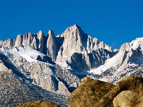
Mount Whitney
If you don't mind driving another fifty miles, there are many campgrounds along Bishop Creek just to the west of Bishop. There are also many places in The Buttermilks area that are close to a creek that are suitable for camping. Please do not camp in The Buttermilks bouldering area. That area is very crowded and is suffering from the impact unregulated camping has caused.
The following links should help finding a good campsite
Horton Creek Campground
Rock Creek Canyon
Inyo National Forest
Bishop Creek and vicinity camping
Lizard's Hangout
Lizard's Hangout is the name of a rock formation in Joshua Tree National Park, California.Most visitors to Joshua Tree enter the park from the western entrance. The first few miles of the drive is typical Joshua Tree landscape. If the visitor is non climber, they begin to enjoy the park immediately. But, for the first time to Joshua Tree climber things are quite different. They cannot wait to get to the biggest and the most famous formations such as Intersection Rock and The Old Woman. In the process, they miss a great number of smaller, unimportant-looking formations along the road. Lizard's Hangout qualifies as one such case.
Lizard's Hangout is a close neighbor to Roadside Rock, but with several great advantages. In contrast to Roadside Rock, it sits a few hundred feet off the main road, it faces away from the traffic and it sports several great routes. Best of all, it stays sunny all day long making it an ideal place to hangout on a cold winter day.
============================
It is surprising that this small formation, about thirty feet high, was mostly overlooked by the climbing pioneers to Joshua Tree for decades. The most inviting cracks in the middle of the face didn't get led until the late 1980s. Nowadays, however, Lizard's Hangout gets regular visits by climbers looking for several moderate crack routes very close together. Many parties don't bother leading these short pitches and they opt for top-roping the routes. It is very easy to scramble to the top from the backside and find many cracks and features for setting up anchors. In addition to the cracks and the face routes, Lizard's Hangout offers a number of traverses and boulder problems that can be found to the left of the south face. This is an enjoyable area to get a little workout if you are looking for an easy day not too far from the road.
To get to Lizard's Hangout, drive 7.1 miles from the west entrance to Joshua Tree National Park. This rock formation is just before you reach Roadside Rock and “Lost Horse Road.” You can park in a small pullout by the road or park by the bathrooms on Lost Horse Road and walk back about 250 yards to the rock. If you go as far as Hemingway Buttress parking, you have gone too far.
================================
| select routes of Lizard's Hangout | |
| A | Lizard Breath, 5.5, Standard Rack, extra big pros |
| B | Progressive Lizard, 5.9, Standard Rack, |
| C | Left Lizard Crack, 10d, Standard Rack |
| D | Right Lizard Crack, 5.9, Standard Rack |
| E | Lizard Skin, 5.8, Standard Rack |
| F | Poodle Lizard, 5.7, face, Standard Rack |
Links
Needle Spoon------Rlleywyna------------
Dike Route ----------by Asteel
Bishop Pass Trail
| |||
|
| ||


=================================
==============================================
===============================================
| Pine Creek Canyon | |
========================================
Area & Range links
| |||
|
| ||


16-old adapted to the new
 sunsets on Lizard's Mouth |
17
| |||
|
| ||
18
| Pine Creek Canyon | |
17
18
 | ||
 |  |  |
19
 | ||
 |  |  |