Let me tell you three stories that are then almost four. But very true, but exclusively three. Others another time ...
Voglio raccontarvi qui tre storie che poi son quasi proprio quattro. Però vere, anzi verissime, ma sol tre delle quattro. L'altre per un'altra volta ancora ...
But how many Saints there were in Aosta Valley? Many. And how Blesseds? A little less. Hermits? Rare. Is a "metier & job" that requires too many sacrifices ...
Ma quanti Santi ci son stati in Valle d'Aosta? Più che molti. E quanti Beati? Un pò mi meno. Ed Eremiti? Rari. Questi é "mestier" che richiede troppi sacrifici ...
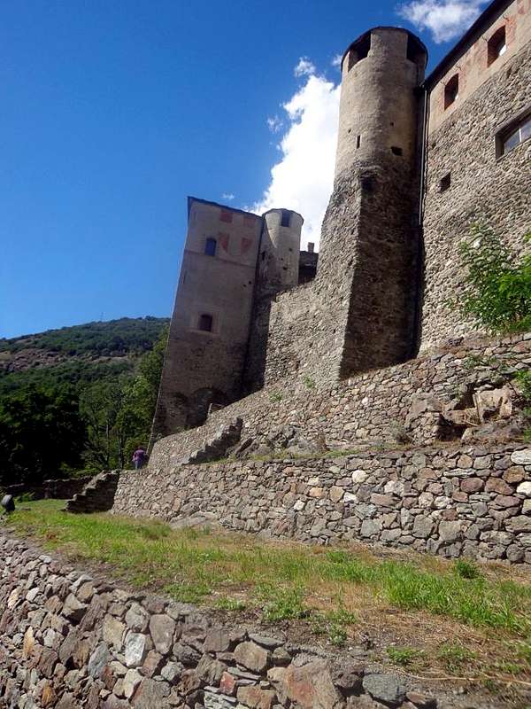
We're not to disturb the Holy Anselm of Aosta (Philosopher, Theologian, Prior and Abbot of the Abbey of Bec-Héluin, Archbishop of Canterbury for intervention of King William II°, Primate of England and made Holy by Pope Urban II° after the Council of Bari calling it "the greatest genius of the Century" and naming him "Doctor of the Church"), which was too big but also too far from this valley, while the hearts of the people are facing in San Grato of Aosta, the Patron of the City and Valley, in St. Emeric or Americo, of Quart, made Blessed by the Vatican as Bishop of Aosta, and St. Julien, that someone wants to turn into Santa Giuliana female, ancient Hermit persecuted by the Romans or more "modern" Hermit Ollomont transferred in Fénis Commune. Then we have other, but, it is not difficult to imagine, as are more than those of the first type that of the other: Rodolfo of Valpelline made Bishop of Sion in 1271, which now rests in the Grande Chartreuse. And then the Abbots "local" as Pierre Chanoux Champorcher (Mountaineer, Naturalist, Scientist for 49 years Rector of the Hospice of the Little Saint Bernard), Boniface of Macynod Roisan (Canon and Doctor to the Court of Amedeo VI°, Scientist in Chambery since 1362 Rector of the "Hospital of the Maladière" in Aosta Town), Léon Clément Gerard (great Poet and Author of 50,000 verses in French), Jean Baptiste Cerlogne St. Nicolas (Poet "patoisan" and Author of a dictionary and a grammar in dialect), Monsignor Giuseppe Augusto Duc Aosta (Prelate and Historian, "the youngest and the oldest Bishop of the World" and author of "Histoire de l'Eglise d'Aoste" in 10 volumes in French, the Abbé Aimé Gorret Valtournanche the famous "Ours de la Montagne", winner in 1865 of the Italian Cervino or Matterhorn), the Abbé Georges Carrel Chatillon (Mountaineer, Scientist and Naturalist), Abbé Joseph Mary Henry Courmayeur (Pastor to Valpelline by half Century and Tutelary Deity of the Toponymy and Author numerous works concerning the "History of the Aosta Valley" and its mountains) etc. in a crescendo that goes almost to infinity. Us, not to do harm to no one, we went to find three. One for each "category", with good peace of all ...
Non stiamo a scomodare Sant'Anselmo d'Aosta (Filosofo, Teologo, Priore ed Abate dell'Abbazia di Bec-Héluin, Arcivescovo di Canterbury per intervento del Re Guglielmo II°, Primate d'Inghilterra e fatto Santo dal Papa Urbano II° dopo il Concilio di Bari definendolo "Il più grande Genio del Secolo" e nominandolo "Dottore della Chiesa"), che é stato troppo grande ma anche troppo lontano da questa Valle, mentre i cuori della Gente son più rivolti a San Grato di Aosta, Protettore della Città e della Valle, a San Emerico o Emeric di Quart, fatto Beato dal Vaticano come Vescovo d'Aosta, e Saint Julien, che qualcuno vuol tramutare in Santa Giuliana al femminile, antico Eremita perseguitato dai Romani o più "moderno" Eremita d'Ollomont trasferitosi a Fénis. Poi ne abbiamo altri, ma , non é difficile da immaginare, come sian più quelli del primo tipo che non tutti gli altri: Rodolfo di Valpelline fatto Vescovo di Sion nel 1271, che oggi riposa nella Grande Chartreuse. E poi gli Abati "locali" come Pierre Chanoux di Champorcher (Alpinista, Scienziato Naturalista e Rettore per 49 anni dello Ospizio del Piccolo San Bernardo), Bonifacio di Macynod di Roisan (Canonico e Medico alla Corte di Amedeo VI°, Scienziato a Chambery e dal 1362 Rettore dello "Ospedale della Maladière" ad Aosta), Léon Clément Gerard (grande Poeta e Autore di 50.000 versi in francese), Jean Baptiste Cerlogne di Saint Nicolas (Poeta "patoisan" ed Autore di un dizionario e di una grammatica in dialetto), Monsignor Giuseppe Augusto Duc (Prelato e Storico, "il più giovane ed ilpiù vecchio Vescovo del Mondo" ed Autore de "Histoire de l'Eglise d'Aoste" in 10 volumi in francese, l'Abbè Aimé Gorret di Valtournanche il famoso "Ours de la Montagne", vincitore del Cervino italiano), l'Abbé Georges Carrel di Chatillon (Alpinista, Scienziato e Naturalista), l'Abbé Joseph Maria Henry di Courmayeur (Parroco a Valpelline per mezzo Secolo nonché Nume tutelare della Toponomastica ed Autore di numerose opere concernenti la "Storia della Valle d'Aosta" e le montagna della valle di Aosta) ecc. in un grande crescendo che và quasi all'infinito. Noi, per non fare torto a persona, siamo andati a trovarne tre. Uno per ogni "categoria", con buona Pace di tutti ...
We're going to annoy the Hermit
In those days the World was already Global. Only that, instead of importing soccer players, basketball and cycling, they were imported gladiators, mercenaries, artists, saints, poets, navigators & Hermits. Every Epoch he had his obsessive ideas, so at the beginning of the first Millennium were fashionable even the Saints and some Hermits, which was the lead of today's immigrants. But he did not damage and is locked up in some cave or crevice of the rock to meditate and pray. Until, merging with Eternity, he disappeared into thin air and remained only in the Popular Memory. But no to the Saints, Blesseds: these were dedicated Churches with frescoes, Shrines, Oratories, golden statues or silver and, if they were to lower lineage or the people were more miserable, had to settle for a few small votive chapel and wooden statues, even stone ...
Between "our" Hermits St. Julien was one of the most famous. But who was he? Where it was and what was he doing it is something somewhat controversial.
See History and Legend.
A quei giorni il mondo era già Globale. Sol che, invece di importare giocatori di calcio, basket e ciclismo, s'importavano gladiatori, mercenari, artisti, santi, poeti, navigatori ed Eremiti. Ogni epoca ha avuto le sue idee ossessive, quindi all'inizio del primo Millennio andavan di moda anche i Santi e qualche Eremita, che era come gli odierni immigrati. Ma non faceva danno alcuno restando rinchiuso in qualche grotta od anfratto nella roccia per meditar e pregar in riservata solitudine. Fino a che, fondendosi con l'Eternità, scompariva nel nulla rimanendo sol nella collettiva Popolar Memoria. Ma ciò non valeva per Santi e Beati: a lor venivan dedicate Chiese con affreschi, Santuari, Oratori, statue d'oro o d'argento ed, in caso di più basso lignaggio od il Popolo più miserabile, si dovean contentar d'una cappelletta votiva o di statuette in legno oppur in pietra ...
Trai "nostri" Eremiti il Saint Julien è stato uno dei più famosi. Ma chi era costui? Donde venisse e cosa vi facesse in Val d'Aosta é cosa alquanto controversa.
Vediamo Storia e Leggenda.
San Giuliano, according to the register of the parish in 1909, already existed in the Year 1650. Three documents, however, show that existed long before: an act from 1327, a report of the pastoral visits, dated November 24, 1441, the third, finally, is a very relevant document dated 30 March 1537, with specific reference to the Hermitage. For the Legend, the same was constructed in the identical position in which occurred the Martyrdom of St. Julian, a Christian prisoner of the Roman Centurions who forced him to work together with other slaves in the Mines of Misérègne in Val Clavalité. It seems that, because his Faith, who warned preaching among themselves and to the soldiery, they have led to the cliff throwing him downstairs. His friends, for a perpetual memory, built a church in the place of the event. It seems, too, that his mortal remains are walled up behind the Altar. An ancient custom makes the first Thursday of the month of May, hold a Procession to the Mount, where comes a Mass celebrated.
In the Hermitage lived since 1865 a Hermit, who survived asking Alms in the Village and in the Parish Fénis. After a couple of Centuries, the chapel was built in his honor.
Subsequently, the Municipality of Fénis granted to another Hermit to settle here: it was 1777, when Champier Jean-Pierre de Mathieur was allowed to dwell. Born in Ollomont in Valpelline May 12, 1751, was orphaned as a child, finding hospitality at the Convent of the Capuchins in Aosta Town, the Freiburg and others, always in Switzerland. The hermit stood Champier Fénis long and then retired to his native country, where he made new home, always as a hermit on the left of the chapel of Notre-Dame des Neiges sur les Vignettes. He died before 1830. The last Hermit who lived in Saint Julien was Jean-Pantaleon Lavy, who, watch case, was born in 1830, died in December 14th, 1864. A second Legend, reported by Fornelli in "Guide Emilius Rosa dei Banchi Park M.Avic", by G. Berutto & L. Fornelli, Edit. C.A.I./T.C.I., March 2005 tells instead of a Pastor thrown from the top, after a quarrel, and from other pastors who had miraculously saved "landing" after a terrible flight, on that rocky ledge, where was built the Hermitage . Another Rumo(u)r with piece of Gossip is the home of the Hermit instead coincide with the ruin which meets immediately began the descent, after the St. Gratus Shrine. And, again, be noted that the Charter gives the Italian Military Geographic Institute (I.G.M.) name as "Santa Giuliana", or female. The pronunciation in French leaves little difference between Julien and Julien(ne) with the final "ne" almost nose, an ear that little educated and sophisticated in the knowledge of the language transalpine can easily "be taken by Deception" and misrepresent. But the presence of a small votive chapel dedicated to Saint Julien at the entrance to the below Val Clavalité seems to solve any doubt. Also, with a bit of Fantasy, we say, has not been the case for a so-called "Witch" which, in the Middle Ages, to escape the Stake, here it is repaired? The choice is Yours ...
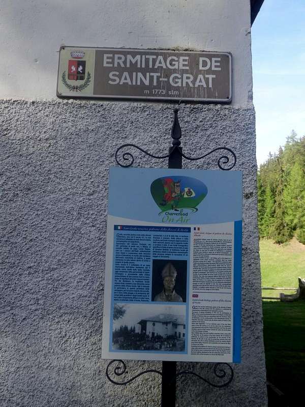
The renowned Shrine of St. Julien (about 1750/60m), by Chiara
San Giuliano, come dai registri parrocchiali del 1909, esisteva già dal 1650. Tre documenti, tuttavia, dimostrano che sussisteva da molto tempo prima: un atto del 1327; un verbale delle visite pastorali, datato 24 novembre 1441; il terzo, infine, è un documento alquanto pertinente datato 30 marzo 1537, con preciso riferimento all'Eremo. Per la Leggenda, lo stesso fu costruito nell'identica posizione attuale nella quale avvenne il Martirio di San Giuliano, a quanto pare un Cristiano prigioniero dei Centurioni Romani che l'obbligavano al lavoro insieme ad altri Schiavi nella Miniere di Misérègne. Causa la sua Fede, che promulgava predicando tra gli stessi nonché alla soldataglia, sembra l'abbian portato al dirupo gettandolo dabbasso. I suoi amici, a perenne ricordo, costruiron una chiesetta nel luogo dell'evento. Par, inoltre, che le sue spoglie mortali sian murate a tergo dell'Altare. Un'antica Usanza fa sì che nel primo giovedì del mese di maggio si tenga una Processione al Monte, ove vien celebrata la Santa Messa.
Nell'Eremo viveva dal 1865 un Eremita sopravvivendo con le Elemosine del Villaggio e della Parrocchia di Fénis. Trascorsi un paio di Secoli, fu costruita la Cappella in suo onore.
Successivamente il Comune di Fénis concesse ad un altro Eremita di stabilirsi qui: era il 1777, quando Champier Jean-Mathieur de Pierre ottenne il permesso di prender dimora. Nato a Ollomont in Valpelline il 12 Maggio 1751, rimase orfano fin da piccolo, trovando ospitalità presso il Convento dei Cappuccini di Aosta, quello di Friburgo ed altri, sempre in Isvizzera. L'eremita Champier permase in Fénis a lungo onde ritirarsi nel suo paese natale, ove si fece nuova casa, sempre da eremita, sulla sinistra della cappella di Notre-Dame des Neiges sur les Vignettes. Morì prima del 1830. L'ultimo Eremita vissuto a St. Julien fu Jean-Pantaléon Lavy, che, nato, guardacaso, nel 1830, ivi morì il 14 Dicembre 1864. Una seconda Leggenda che appar "più locale", riportata da Fornelli in "Guida Emilius Rosa dei Banchi Parco del M.Avic", di Giulio Berutto e Lino Fornelli, Editato da C.A.I./T.C.I. nel 2005. pagine 176/7, narra invece d'un Pastore gettato dall'alto, dopo furibonda lite, da altri pastori del posto e che s'era miracolosamente salvato "atterrando", dopo un volo immane sul dirupo, su quella cengia rocciosa, ove é stato costruito l'Eremo: " ... Da allora ogn'anno il 5 di giugno vi si celebra la Messa per la festa del Santo ...". N'altra Diceria fa invece coincider l'abitazione dell'Eremita col rudere che trovasi appen iniziata la discesa, dopo il Santuario di San Grato. Ed, ancora, da osservar che la Carta dell'Istituto Geografico Militare Italiano (I.G.M.) riporta il toponimo come "Santa Giuliana", cioé al femminile. La pronuncia in francese lascia poca differenza tra Julien o Julienne con il "ne" finale quasi nasale, tal che un'orecchio poco educato e sofisticato nella conoscenza del linguaggio transalpino può facilmente "esser preso d'Inganno" e travisar. Oppur infine e con un pò di Fantasia, diciam noi, non sarà stata per caso 'na cosiddetta "Strega" che, nel Medio Evo, per sfuggir al Rogo, qui s'é riparata? A Voi la scelta ...
As you come to the Heremita?
From the Village of Fénis, accessible from Highway n° 26 crossing the bridge over the Dora Baltea Stream, just after the Country of Nus (output Motorways A7), arriving at the junction 539 meters, and immediately after the field of Football, leave the roundabout to the left on the same (large signals), and go up to the Chief Lieu. Following the signs in color marron "Saint Julien" and, still leaving the Municipal Road to the East to Barche Hamlet and towards Clavalité Vallon satisfy the signs for the "Vallon of Pieiller", a tarmac road dates back to the South, starting between the Villages of Le Perron (582m) and Pommier (614m), and through road bends that door, through the woods, to the small Village of Le Boit-du Chat (695m) and the subsequent of Champlan. After four more through the hairpin road nearby the Torrent Bioley and goes West towards the basin left its course, always with tight bends reaches Le Pieiller-de-Sermaz (1075m) and then Maison Longue (1112m) and nearby Le Plany (1174m), with a last bend to the West toward the Morgettaz Hamlet reach the junction, with small parking lot on the floor, for the little semi-abandoned "Ghost Village" Le Coteau (1234m).
Western Slope or Standard Via
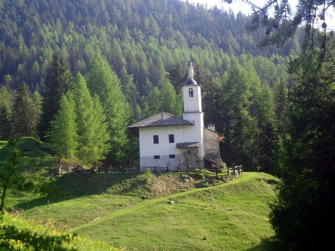
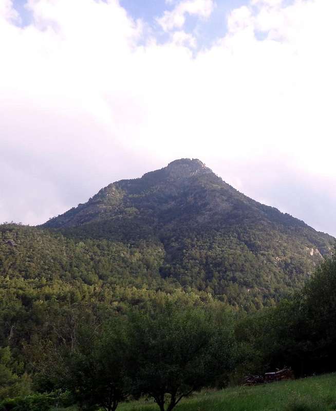
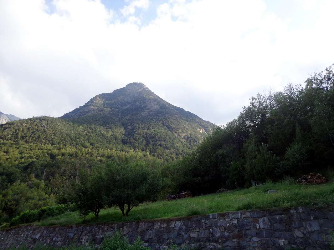
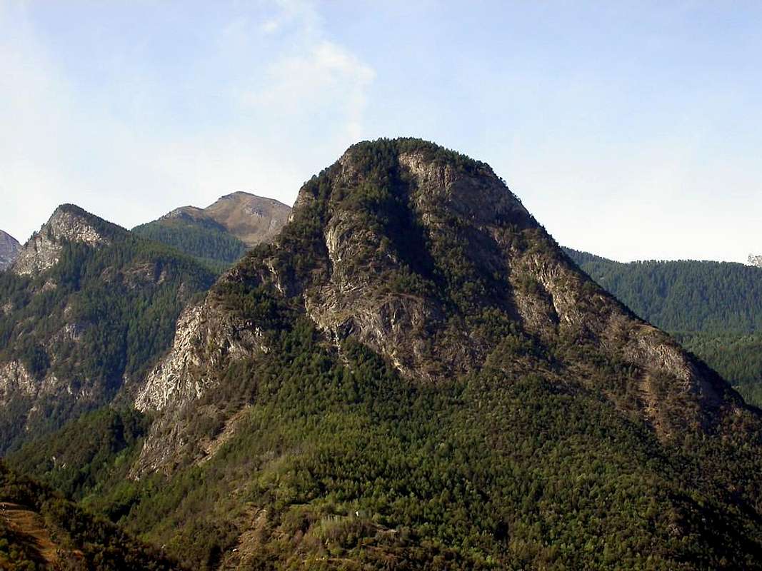
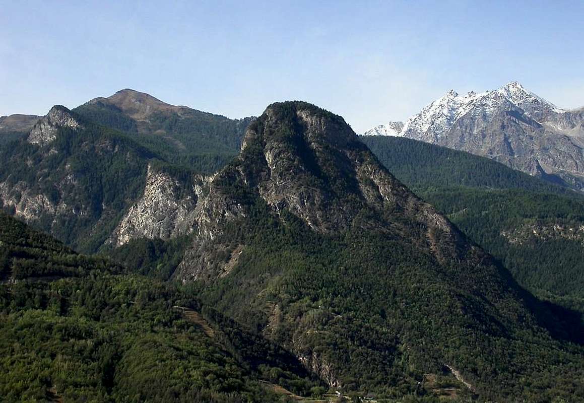
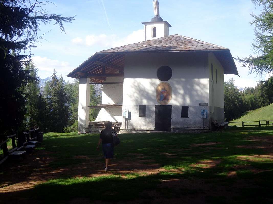
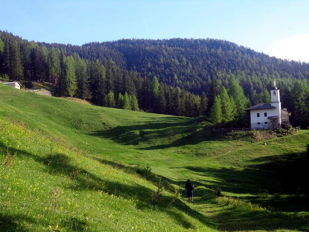
It starts with the path n° 10B (wooden signpost for St. Julien) at the hairpin-junction between the villages of La Morgettaz and Le Pieiller (1230m) after a short distance on a dirt track and soon you get to the source village "Phantom" by Le Coteau (1234m), in the woods. Here is another similar sign, hanging from the old alp, half in ruins and in front, pointing towards the South direction, a small ramp leading to the little votive Chapel/Oratory of St. Joseph, just behind the old village, now abandoned (one renovated house) and looking ghostly, where in times not so long ago there was "Life". He turns to the East and with gentle climb you pass a brook with a flat stone, which acts as a miniscule bridge, leaving below a pasture with grass at the edge of the woods that is about to go broke, you continue progressing toward Northeast until meet the plates of polished rock and blackish (aimed at a small climbing didactics; in the area are succulents). The trail begins to rise before addressing slope towards a grassy collar, scrapping on the left, (Collar of Saint Julien? Impassable because beyond presents a vertical rock face) and then decisively in the direction of North to a long wooden boardwalk that a good fence protects against a quantum leap rock, above the Walloon of Pieiller. The next stretch leading to the wooden walkway that "cuts" the West Slope with a diagonal to the North, and very exposed an impressive leap rock, but protected by a fence that is hanging in the balance at the end because, due to the winter snow, it is off exit from its base. You have to pay a little attention, especially in the presence of childrens. After crossing the same, the trail climbs to the North-northeast, and with a beautiful stone staircase, pleasant to go, achieving a rampart with beautiful views of the Central Valley, the Dora Baltea River and the City of Aosta; while the West stands the Range Roèses (to photograph must come in the morning), preceded by the South Coast more than Mount Saint Julien goes up to the nearby Mont Torrasse or La Touriasse (1854m), Mount Corquet (2527m) to eventually decline with semi-circular route to Mount Roux (2277m), the site of ancient Ironmines & Copper. Turning to the right with a nice diagonal through the woods, on the trail soft, slightly steep and studded safe from dawn of mushrooms, you get to the St. Grat Sanctuary with octagonal Church its high, white and square (0h'35/0h'40). The true Summit is just above and you can reach in a short time with a trace of grass and trees just to the right (West) of the same.
Descent
Eastern Face or Normal Descent Route to Old Hermitage
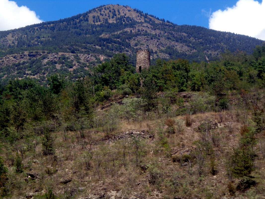
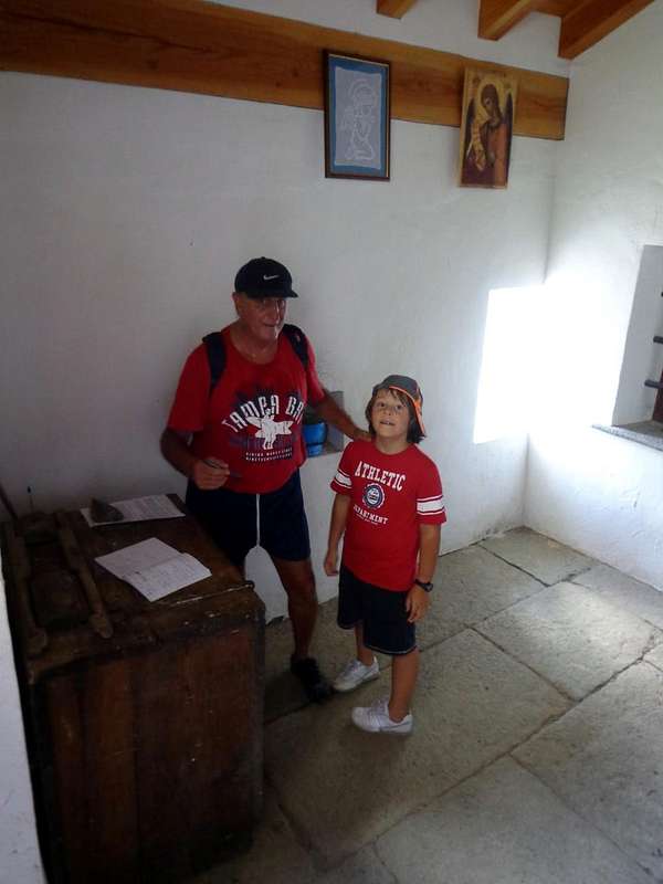
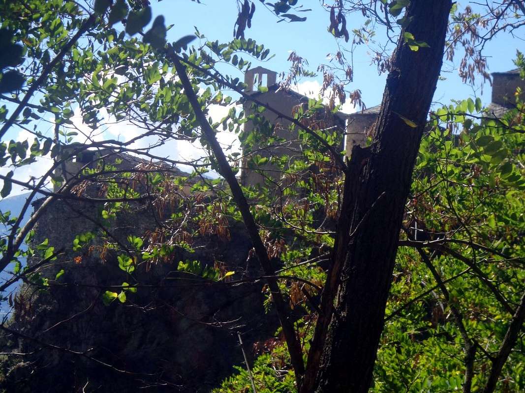
The descent on the Eastern Side begins just after the church with docile path, marked by a sign hanging on a fir. From this began a short diagonal, with two old trees cut down by the storm, which reaches a first bend to the left with a view to the remains of an ancient mountain pasture (or was this the original Hermitage?), with a further series of hairpin bends, steep, leading to the back of the great precipice falls with a jump of 346 meters below the Alp Charnicloz (1038m) and more than 500 metres on Torrent Clavalité, downstream of La Cerise Alp (989m) and the entrance of Valley Fénis. The path is protected by a good wooden fence but, in the presence of children, you must multiply the Warnings. The environment is truly impressive: in front meanders across the walloon floor at the foot of Charmontane (2863m), while the far end stands the perfect triangular pyramid of Tersiva, Emblem Fénis. A diagonal final underlying rock walls and vertical (Free Climbing routes are equipped), concludes by getting the path that splits into two sections this wall, protected on the left by small dry-stone walls, the Hermitage (around 1750/60m) where, it seems, lived the Holy One. A white building, clinging to the rock and suspended over a void impressive, marks the end of the path. In addition you can not and you should not go. Hermitage is made up of a chapel with a door that can be opened by a latch at the top, a second iron gate marks the boundary between this input, a small table and sign the book for the transition from the Tourists and the private St. Julien. Icon on the wall, while on the right you can see the excavation in the rock, through which it was possible to carry out the construction (0h'15).
Come s'arriva dall'Eremita?
Dal Paese di Fénis, raggiungibile dalla Strada Statale n° 26 attraversando il ponte sulla Dora Baltea, subito dopo il Paese di Nus (uscita Autostrada A7), arrivando al bivio 539 metri. Immediatamente dopo il campo di calcio, lasciare a sinistra la rotonda sulla medesima (ampie segnalazioni), e salire verso il Capoluogo. Seguendo i cartelli in color marron con l'indicazione "Saint Julien" e, lasciando ancora ad Est la strada Comunale per la Frazione Barche e la Clavalité, assecondare le indicazioni per il "Vallone del Pieiller"; una strada in asfalto risale verso Mezzogiorno, partendo tra le Frazioni di Le Perron (582 m) e Pommier (614 m), e tramite stretti tornanti si porta, in mezzo al bosco, al piccolo Villaggio di Le-Boit du Chat (695 m) ed al successivo di Champlan. Dopo altri quattro tornanti attraversa il Torrent Bioley e si porta ad Ovest verso il suo corso idrografico sinistro; sempre con stretti tornanti raggiunge Le Pieiller-de-Sermaz (1075 m) e successivamente Maison Longue (1112 m) e Le Plany (1174 m). Tramite un ultimo tornante ad Ovest verso la Morgettaz raggiunge il bivio, con ridotto parcheggio in terra, per il piccolo e semi abbandonato "Villaggio Fantasma" di Le Coteau (1234 m).
Versante Ovest o Normale di salita
S'inizia con il sentiero n° 10B (cartello segnaletico in legno per St. Julien) al tornante-bivio tra i Villaggi di La Morgettaz e Le Pieiller (1230 m); dopo un breve tratto in strada sterrata e subito apprwesso la fonte si arriva al Villaggio "Fantasma" di Le Coteau (1234 m), in mezz'al bosco. Qui un altro similar cartello, appeso alla Baita, per metà in rovina e di fronte, indica verso Sud la direzione; una rampetta porta alla piccola cappella votiva Oratorio di San Giuseppe, subito alle spalle del vecchio villaggio, ormai quasi del tutto abbandonato (una sola casa ristrutturata) e dall'aspetto spettrale, ove in tempi neppure troppo lontani c'era la "Vita". Volgesi ad Est e con dolce salita si oltrepassa un ruscello con una pietra piatta, atta a mini ponte; lasciando al di sotto un'alpeggio, che sta per andar in rovina, con prato al limitar del bosco si continua progredendo verso Nordest sino ad incontrare delle placche di roccia levigata di color nerastro (adatte ad una mini arrampicata didattica; nella zona vi sono piante grasse). Il sentiero incomincia ad aumentar di pendenza indirizzandosi dapprima verso un colletto erboso, che scarta sulla sinistra, (Colletto di Saint Julien? Non attraversabile, perché al di là presenta un'erta parete rocciosa precipitante sulla Val Clavalité) e poi decisamente con direzione a Nord verso una lunga passerella in legno che una buona staccionata protegge da un notevole salto roccioso, soprastante il Vallone del Pieiller. Il tratto successivo porta, perlappunto, alla passerella in legno che "taglia" il Versante Ovest con un diagonale a Settentrione, molto esposto su d'un impressionante salto roccioso, ma protetto da staccionata in bilico nella parte finale perché, causa la neve invernale, é fuoruscita dalla sua base d'appoggio. Bisogna prestar un pò d'attenzione, soprattutto in presenza di bambini. Dopo la traversata della medesima, il sentiero sale verso Nord-nordest e con una bella gradinata in pietra, piacevole da percorrersi, raggiunge uno spalto con splendida vista sulla Valle Centrale, la Dora Baltea e la Città d'Aosta; mentre ad Occidente si staglia la Catena delle Roèses (per fotografare bisogna venir di primo mattino), preceduta più a Mezzogiorno dalla Costiera che dal Monte Saint Julien risale alla vicina Torrasse (1854 m), al Mont Corquet (2527 m) per infine declinare con percorso semi circolare al Mont Roux (2227 m), antica sede di Miniere di Ferro e Rame. Voltando a destra con un bel diagonale in mezzo al bosco, su sentiero morbido, poco ripido e sicuro costellato dallo spuntar di funghi, s'arriva al Santuario di St. Grat con la sua Chiesa alta, bianca, ottagonale e squadrata (0h'35/0h'40). La vera Cima é appen sopra e la si può raggiunger in breve con traccia su erba e tra sparuti alberi subito a destra (Ovest) della stessa.
Discesa
Faccia Orientale o Normale di Discesa all'Eremo
La discesa sul Versante Orientale incomincia subito appresso la Chiesa con docile percorso, segnalata da cartello appeso ad un abete. Da questi inizia un breve diagonale, presso due vecchie piante abbattute dalla tempesta, raggiungente un primo tornante verso sinistra con in vista i resti d'un antico alpeggio (oppure era questo l'originario Eremo?); con una successiva serie di tornanti, progressivamente più ripidi, si porta a ridosso del grande precipizio cascante con un salto di 346 metri sulla sottostante Alpe Charnicloz (1038 m) e d'oltre 500 metri sul Torrent Clavalité, più a valle dell'Alpeggio La Cerise (989 m) ed all'imbocco della Valle di Fénis. Il percorso é protetto da una buona staccionata in legno ma, in presenza di bambini, si debbono moltiplicare le Attenzioni. L'Ambiente é veramente suggestivo: frontalmente si snoda tutto il fondovalle ai piedi del Mont Charmontane (2863 m), mentre là in fondo s'innalza la perfetta e triangolare piramide della Tersiva, Emblema di Fénis. Un diagonale terminale, sottostante a pareti rocciose e verticali (sono attrezzate varie Vie di Free Climbing), conclude portando il sentiero, che spezza in due tronconi questa parete con protezioni sulla sinistra tramite muretti a secco, all'Eremo (1750/60 metri circa) ove, sembra, vivesse il Santo. Una costruzione bianca, abbarbicata alla roccia e sospesa su d'un vuoto veramente impressionante, ne segna la fine. Oltre non si può e non si deve andar, poichè estremamente pericoloso. L'Eremo é formato da splendida Cappelletta con porta apribile a mezzo d'un chiavistello posto in alto; una seconda cancellata in ferro segna il limite tra quest'ingresso, con tavolino e il libro per firmare il passaggio da parte dei Turisti, ed il locale di Saint Julien. Appesa alla parete un'Icona, mentre a destra si può ammirare lo scavo nella roccia, tramite il quale é stato possibile realizzar la costruzione e dove par riposi l'Eremita (0h'15).
Alternative Route directly with Departure from Floor Valley
The Old Road to the Mont Saint Julien certainly would not start from Le Coteau ancient Village, but directly by the Fund Valley, nearby Fénis Municipality, with walking paths and trails now gone almost entirely into disuse, and the progressive construction of Roads Regional, Municipal and finally Intercrofting (sometimes reach up to 2500 metres them) have in practice caused him to abandon these ancient means of communication and transport livestock within individual vallons or in various and different connections.
Historical Note
In fact, a whole network of transfer existed in High Altitude and, besides, you should know that the Alta Via delle Alpi was not running on motorways, but through the hills. For example, to go from Venice to Amsterdam and not vice versa certainly walked the Via Romana along the course of Baltea River, which leads from Ivrea to Aosta, the first is dated from the Orco Valley, we climbed over the Hills of Miserino, of Arietta, the Scaletta, the Bocchetta of Rancio or that of Acque Rosse (Red Water), under the Tower of Lavina, to descend into the Cogne Valley until Aymavilles. After, you crossed the Baltea going up on the opposite side to the Village of Thouraz or Thora (buried by collapse of Becca France with its 600 inhabitants July 6, 1564), where he organized four famous European Exhibitions including important that the Seeds, you crossed the unnamed Hill 2674 metres just to the east of Mount Fallère (3061 m) to go down to Etroubles and from there along the Great Saint Bernard Valley spanned the eponymous famous Pass to take to Switzerland and across half of Europe. In addition to these Great Highway where the most important thing was the Horse, but especially the Mule, (you only have to think that the Shelter Vittorio Emanuele II° at Great Paradise (4061m) was supplied in such a way up to more than half of the seventies, then has arrived the Helicopter), there were large Muletracks were built by the Clergy in communion with the local Authorities for the famous Processions, the trails were also held in high regard and order in order to be able to reach the pastures, with the Herds. Paradoxically, of all that there is to be observed as they are kept in a better state the trails at the top, thanks to the mileage of hikers and climbers, while the valley floor or Medium Hill went half destroyed, devoured by vegetation and brushwood.
Without this small but necessary Preamble and returning Topic, said the chance to return to the Old along the entire route from Fénis to the Mount Saint Julien. In this case, the start may be made by the Village Le Perron (582m) going through the route n° 10 which gradually approaches the Torrent de Bioley reaching the road at an altitude of around 820 metres, here comes, but with a larger circle to the West, also the path n° 10A with the same starting point. In addition comes the route n° 11 from Tillier Hamlet (550m) and connecting to Réan Village (898m) in the Municipality of Saint Marcel. From this triple crossing of the trail goes up as n° 11A toward Southeast and reaches the farm at the Torrent de Bioley inserting the primitive n° 10 starting from Le Perron. With parallel trail along the stream of the river basin arrive at Le Pieiller-de-Sermaz Hamlet (1075m) and the branching n° 10B reaches Le Coteau very old Village (1234m) out halfway between fountain and village (1h'30/2h'00; in total for St. Grat Shrine and nearby and just above Mont St. Julien; 2h'00/2h'30). This route allows, in addition to logically a harder workout, the discovery of many specific feature of the "Half Hillock" with a trip more rewarding and the rediscovery of old sites with related lifestyles of another age now completely it is gone and well unlikely to return. Factors not indifferent ...
Via Alternativa direttamente dal Fondovalle
La Vecchia Strada per il St. Julien non partiva certamente dal vecchio Villaggio di Le Coteau, bensì direttamente dal Fondovalle, presso Fénis, con sentieri e mulattiere ormai andati quasi del tutto in disuso; la costruzione progressiva di Strade Regionali, Comunali ed infine Interpoderali (a volte raggiungono anche i 2500 metri!) hanno in pratica fatto si che s'abbandonasero quasi completamente questi antichi mezzi di comunicazione e di trasporto pel bestiame all'interno dei singoli valloni o nel collegamento di diversi di loro.
Nota Istorica
Infatti tutt'una rete di trasferimento esisteva in Media ed Alta Quota ed, inoltre, si deve saper che l'Alta Via delle Alpi non "correva" sulle Autostrade, ma attraverso i colli e le successive vallate. Ad esempio, per recarsi da Venezia ad Amsterdam e viceversa non si percorreva certamente la Via Romana affianco del corso della Dora Baltea, che da Ivrea conduce ad Aosta. Dalla prima cittadina si risaliva circa la metà della Valle dell'Orco, si scavalcavano i Colli del Miserino, dell'Arietta, della Scaletta, la Bocchetta del Rancio o quello d'Acque Rosse, sotto la Torre di Lavina, per scendere in Val di Cogne fino ad Aymavilles. Indi s'attraversava la Dora Baltea risalendo sul versante opposto al Villaggio di Thouraz o Thora (sepolto dal crollo della Becca France con i suoi 600 abitanti il 6 Luglio 1564), ove s'organizzavan 4 famose Fiere Europee tra le quali importantissima quella delle Sementi, si scavalcava il colle innominato 2674 metri subito ad Est del Mont Fallère (3061 m) per discendere nel Comune di Etroubles. Da qui, percorrendo l'intera Valle del Gran San Bernardo, se ne valicava l'omonimo celebre Colle per scendere in Isvizzera ed attraversare mezz'Europa. Oltre a queste Grandi Autostrade ove il mezzo più importante era il Cavallo, ma soprattutto il Mulo, (é sufficiente pensare che il Rifugio Vittorio Emanuele II° al Gran Paradiso era rifornito in siffatta maniera fino ad oltre la metà degli Anni Settanta, poi é arrivato l'Elicottero), v'eran grandi mulattiere fatte costruire dal Clero in comunione con gli Enti Locali per le rinomate e tradizionali Processioni; inoltre i sentieri eran tenuti in gran considerazione ed ordine, onde potere raggiunger gli Alpeggi con le Mandrie. Paradossalmente di tutto ciò v'é da osservar come si sian mantenuti in miglior stato i sentieri in alto, grazie alla percorrenza di Escursionisti ed Alpinisti, mentre quelli di fondo valle o di Media Collina sian andati semi distrutti, divorati dalla vegetazione e dalle sterpaglie nonché dal progressivo, e prevedibile, abbandono dopo la costruzione dell'attuali strade.
Fatto questo piccolo ma necessario Preambolo e tornando in Argomento, dicevam della possibilità di tornare all'Antico percorrendo l'intero itinerario da Fénis al Monte Saint Julien. In si caso la partenza può avvenire dalla Frazione Le Perron (582 m) risalendo tramite il sentiero n° 10 che s'avvicina progressivamente al Torrent de Bioley raggiungendo la Carrozzabile in quota 820 metri circa; quivi giunge, ma con giro più largo ad Occidente, anche il sentiero n° 10A sempre col medesimo punto di partenza. Inoltre arriva il sentiero n° 11 dalla Frazione Tillier (550 m) e pur quello di collegamento da Réan (898 m) nel Comune di Saint Marcel. Da questo triplice incrocio il sentiero risale come n° 11A verso Sudest e raggiunge la poderale presso il Torrent de Bioley inserendosi sul primitivo n° 10 sempre di Le Perron. Con percorso parallelo lungo il rivo idrografico del torrente arriva a Le Pieiller-de-Sermaz (1075 m) e con la ramificazione n° 10B raggiunge infine le baite di Le Coteau (1234 m) uscendone a metà strada tra la fontana ed il villaggio (1h'30/2h'00; in totale per il Saint Julien 2h'00/2h'30). Questo percorso permette, oltre a logicamente ottenere un allenamento più duro, la scoperta di molte peculiarietà della "Mezza Collinetta" con gita maggiormente remunerativa e riscoperta di vecchi siti con relativi modi di vivere di un'altra epoca. Fattori non indifferenti...
Bishop Emerick to pray bAccompaning eneath the cliffs of Valseinte
In add to Anselm, Grat, Orso, Giocondo the ancient Diocese of Aosta also includes St. Emeric(k) or Americo Quart. Born in the Castle of Villair in mid XIII° Century was often mistaken for a Hermit or Saint; instead is a Blessed who was going to do penance and to pray in a hermitage above the castle just that as a result of these events became the Val Sainte or Valseinte. Now his figure wavers between History & Legend and even his name Emeric, Emerico and, most likely, Americo oscillates between the three versions. However, apart from some forward-looking Map, we find in the Hill of Quart the Village of Amerique, while the locality on the bottom of the valley is called Région Amerique or America. That has nothing to do with America but, rather, recalls an old popular name in honor and memory of the Hermit, and also the Holy Blessed...
Oltre ad Anselmo, Grato, Orso e Giocondo l'antica Diocesi di Aosta annovera pur Sant' Emerico o Americo di Quart. Nato nel Castello del Villair a metà del XIII° Secolo é spesso scambiato per Eremita o Santo; invece é un Beato che andava a far penitenza pregando in un Eremo sopra il castello, di quella che a seguito di queste vicende divenne la Val Sainte o Valseinte. Ormai la sua figura vacilla tra Storia e Leggenda ed anche il nome di Emeric, Emerico e, più probabile, Americo oscilla tra le tre versioni. Però, a parte qualche Carta lungimirante, troviamo nella Collina di Quart il Villaggio di Amerique, mentre la località sul fondo valle é detta Région Amerique od America. Che non ha nulla a che fare con l'America ma che, piuttosto, ricorda una vecchia denominazione popolare in omaggio e memoria dell'Eremita ed anche del Santo Beato ...
How to get to Blessed Emerick's or Saint Americo's Hermitage
As you reach the Oratory? There are different ways of reaching the oratory of Blessed Emeric. Among the various we try to analyze some of them:
By the Villair of Quart
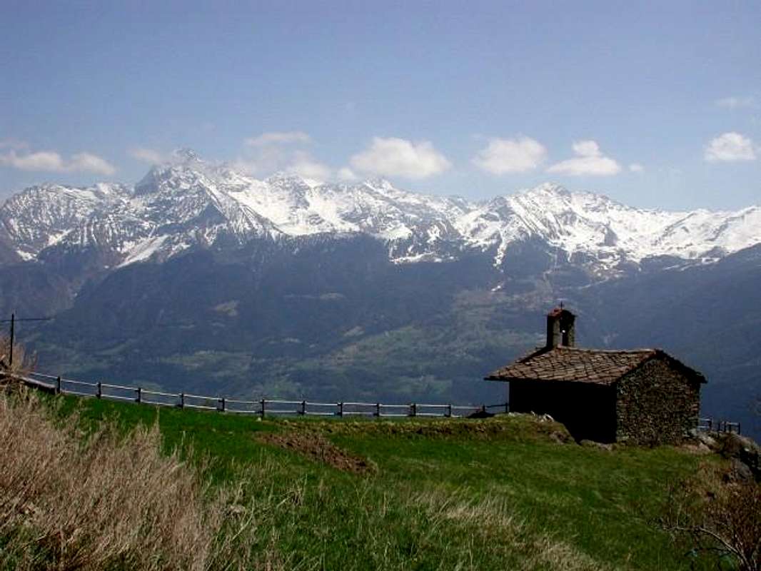
1)- From the Château de Quart Northern side, left in the bottom right a detour with steep farm dirt road that comes from the junction 725 metres after the Village of Verney, apart from a small path marked but not numbered rising towards the Northeast. A first series of steep switchbacks, protected by a wooden fence, beyond the rocky promontory above until you reach first the hill 1018 metres and then flexing further North, closer to a small stream dried; a successive series of hairpin bends into the forest leads to the Torrent du Château. Crossed twice the same, with a short diagonal towards the Northeast in the thick Bois (forest) of Emeric or Americo, you reach the Oratory with small altar topped by a cross (1130/40m; T/E; 1h'00/1h'15), at the farm road that descends from the Pasture of Valseinte (1399/40m), in West by Avisod (Trois Villes).
Come s'arriva all'Oratorio del Beato Emerico o di Sant'Americo
Come si raggiunge l'Hermitage? Diverse sono le possibilità per raggiungere l'oratorio del Beato Emerico. Tra le varie, proviamo ad analizzarne qualcuna:
Dal Villair de Quart
1)- Dal Château de Quart lato Settentrionale, lasciata in basso a destra una deviazione con ripida strada poderale che arriva dal bivio 725 metri dopo il Villaggio di Verney, parte un sentierino segnalato ma non numerato, che sale verso Nordest. Una prima serie di ripidi tornanti, protetti da staccionate in legno, supera il soprastante promontorio roccioso fino a raggiungere dapprima il promontorio 1018 metri e poi, flettendo più a Nord, avvicinarsi ad un torrentello essiccato; una serie successiva di stretti tornantini dentro la foresta conduce al Torrent du Château. Attraversato due volte il medesimo, con un breve diagonale verso Nordest dentro il fitto Bois (foresta) d'Emeric o Americo, si raggiunge l'Oratorio con piccolo Altare sormontato da Croce (1130/40 m; T/E; 1h'00/1h'15), presso la strada poderale che scende dall'Alpeggio di Valseinte (1399/40 m).
From the Regional Road towards the small Trois Villes Villages
2)- From the Village of Avisod (Trois Villes) (1398m). from the Village of Vignil (946m, near the Necropolis Neolithic Vollein) continue through the Regional Road first Eastward and slightly to the North, reaching the Village Fornail (1082m; Chapel of Sainte Barbe); bending over in the Northeast region will then approach the Villages of Ville-sur-Nus (1113m; beautiful Parish Church with Bell Tower lined with copper, preceded by a stone votive Chapel dedicated to Our Lady), Buignod (1135m; "Rascard" square and wooden), Porsan (1299m) and Avisod (1398m, beautiful small Church dedicated to St. Margaret, Rocco and Anselme; just above beautiful fountain at the remains of the ancient Belfry of Trois Villes). Left to right continuing for the "Monument to the Partisan" (1364m) and, above, that for the last Fonteil Village (1423m), you cross to Avisod until the start of the private dirt road towards the Basin Sénevé. The same goes up with modest elevation West-northwest by cutting the base around the South Slope of the Croix de Fana (2212m) to reach a crossroads approximately in 1420/30 metres. Left to right, the branch continues to Chacotte, Champchamoussin, Latta Pastures into the Comba Cénevé also Senevé, instead you drive down to the Southwest reaching first a stable for sheep and horses and immediately then the Valseinte Alpage (1399m; fountain). Now the private road descends steeply to the South-southwest in a small valley (the real and true Valsainte) dark and threatening with steep cliffs below the Bois d'Emeric; the same is directed towards these but not reached, but falls vertically to the South over the Oratory (EE/F; 1h'00/1h'15 from Village of Avisod; remember well and scrupulously that the return is uphill for which it almost doubled travel time). Or, organizing logistically, down through the first of the itineraries to Villair de Quart (E/T; 0h'30/0h'40).
Dalla Strada regionale verso i Villaggetti di Trois Villes
2)- Dal Villaggio Avisod di Trois Villes (1398 m). Dal Villaggio di Vignil (946 m; nelle vicinanze della Necropoli Neolitica di Vollein) si prosegue tramite la Strada Regionale dapprima verso Oriente e poi a Settentrione raggiungendo il Villaggio di Fornail (1082 m; Cappella di Sainte Barbe); piegando più a Nordest la Regionale raggiunge in successione i Villaggi di Ville-sur-Nus (1113 m; bella Chiesa Parrocchiale con Campanile foderato in rame, preceduta da Cappella votiva in pietra dedicata alla Madonna), Buignod (1135 m; "Rascard" quadrato ed in legno), Porsan (1299 m) ed Avisod (1398 m; bella Chiesetta dedicata ai Santi Margherita, Rocco ed Anselmo; appena sopra bel fontanile presso i resti dell'antico Campanile di Trois Villes). Lasciata a destra la continuazione per il "Monumento al Partigiano" (1364 m) e, sopra, quella per l'ultimo Villaggio di Fonteil (1423 m), si attraversa quello di Avisod fino all'inizio della poderale verso la Conca di Senevé. La stessa sale con modesto dislivello verso Ovest-nordovest tagliando alla base tutto il Versante Meridionale della Croix de Fana (2212 m) sino a raggiungere un bivio a circa 1420/30 metri. Abbandonato a destra il ramo che prosegue verso gli Alpeggi di Chacotte, Champchamoussin, Latta nella Comba di Senevé oppure Cénevé, si scende invece a Sudovest raggiungendo dapprima una stalla per pecore e cavalli e poi l'Alpe di Valseinte (1399 m; fontana). Ora la poderale scende decisamente verso Sud-sudovest dentro un valloncello tetro e minaccioso con ripide pareti rocciose sottostanti il Bois d'Emeric; la stessa s'indirizza a queste ma non le raggiunge, bensì scende in verticale a Sud sopra l'Oratorio (EE/F; 1h'00/1h'15 da Avisod; ricordare con scrupolo che il ritorno avviene in salita per cui quasi raddoppiare il tempo di percorrenza). Oppure, organizzandosi logisticamente, scendere col primo degli itinerari al Villair de Quart (E/T; 0h'30/0h'40).
Historiographical Remarks
St. Emeric(k) or, perhaps better, Americo was born around 1255 in the then newly constructed (1185) Castle of Quart, in the small hamlet of Villair, with, at that time, all inhabitants gathered at the foot of the same. Son of Noble Wilhelm II° attended the University in Turin, where he received his PhD in Theology. By nature shy, humble and shy, he returned to his homeland where he retired in penance and prayer in the wild narrow and little valley above the castle which became the Valseinte or Val Sainte and which now features, in around the midst and in one hour about of steep walk with small path, an oratory with a Chapel and Altar outdoor topped by a cross. Probably after this stage contemplative became part of the Canons of Sant'Orso or as a deacon at the Cathedral of Aosta, but the fact is that his "career" ecclesiastical became radiant as a result of merit acquired and universally recognized in the rescue of souls, so that in the death of the Bishop of Aosta Nicholas I° Bersatori (1301) became its successor (with consecration by Aimone of Challant, Bishop of Vercelli Town), in Biella Bourg occurred towards the end of that year. His fù a work of supreme penalty is against clerics that priests giving such an example of life frugal and modest life and lavishing much alms, while reserving to himself only the minimum necessary to live. Overcoming the uncertainties of early youth he became a man, while remaining always humble and meek, wise and of strong character with considerable and firm decision-making skills. Forcing the priests were selecting the residence, handed out alms, helping the Diocesan Churches and sided in defense of the rights and duties of the People measures to take account, nevertheless an inflexible behavior, he was loved by all. He built a large number of churches, she came to the fore as a spiritual Writer and Historian with an important work on the costumes of 1305 and two years later summoned the Diocesan Synod, and in 1311 established a "Feast of the Conception of the Virgin Mary". He held the post of Bishop since 1302 until 1313, died on September 1th of that year and buried in the Cathedral of Aosta. Considered the author of numerous Miracles, was beatified by the people and by the Bishops of Aosta and is popularly believed whether as Hernit that a Holy. A combination of merits and awards such as to transform her figure in a Legend that found recognition, however, only 14th July 1881 by Pope Leo XIII° that recognized in the canonical process with the title of Blessed. Meanwhile the People from the time to pay homage and respects as such and in 1551 his remains were exhumed in a reliquary, visited by more and more people like the Oratory, where he seems to have remained the signs in the rock of his knees for constant prayer and penance, still object pilgrimage tours or of the simple curiosity. In Quart, native soil, it is celebrated on September 1th, while for the Feast of the Martyrs in the Vatican Calendar, instituted in 1586 by the Pope Gregory XIII°, this date is set just a month before. In the end we must conclude that Emerico fù for the populace a Hermit, for the Church a Blessed and for the People a great Saint ...
Note Storiografiche
San Emerico o, forse e meglio, Americo nacque intorno al 1255 nell'allora appena costruito (1185) Castello di Quart, nella piccola Frazione del Villair, a quei tempi tutta riunita ai piedi del medesimo. Figlio del Nobile Guglielmo II° frequentò l'Università degli Studi in Torino, dove conseguì il Dottorato in Teologia. Di carattere schivo, umile e timido, ritornò alla sua terra natia dove si ritirò in penitenza e preghiera nel selvaggio vallone sopra il castello che diventò la Valseinte o Val Sainte e che oggi presenta, a circa la metà e ad un'ora di ripido cammino con sentierino, un Oratorio con Altare all'aperto sormontato da una Croce. Probabilmente dopo questa fase contemplativa entrò a fare parte dei Canonici di Sant'Orso oppure come Diacono alla Cattedrale di Aosta, ma stà di fatto che la sua "carriera" ecclesiastica diventò fulgida a seguito dei meriti acquisiti e universalmente riconosciuti nel soccorso delle anime, tanto che alla morte del Vescovo di Aosta Nicola I° Bersatori (1301) ne divenne il successore con consacrazione da parte di Aimone di Challant, Vescovo di Vercelli, avvenuta a Biella verso la fine dello stesso anno. Il suo fù un operato di sommo rigore sia nei confronti dei chierici che dei sacerdoti dando esempio con una vita parca e morigerata ed elargendo molte elemosine, mentre a se stesso riservava esclusivamente il minimo necessario per vivere. Superate l'incertezze della prima giovinezza diventò un uomo, pur restando sempre umile e docile, saggio e di forte carattere con notevoli e ferme capacità decisionali. Selezionava i preti obbligandoli alla residenza, elargiva elemosine, aiutava le Chiese Diocesane e si schierò in difesa dei diritti e relativi doveri del Popolo. Ciononostante, per quanto inflessibile nel comportamento, era da tutti amato. Fece costruire un notevole numero di Chiese, si mise in luce quale Scrittore spirituale e Storico con un importante opera del 1305 sui costumi dell'epoca e due anni appresso convocò il sinodo Diocesano, mentre nel 1311 istituì una "Festa del Concepimento di Maria Vergine". Mantenne l'incarico di Vescovo dal 1302 al 1313, morendo il primo di Settembre dello stesso anno e riposa nella Cattedrale di Aosta. Ritenuto autore di numerosi Miracoli, venne beatificato dalla gente e dai Vescovi di Aosta e popolarmente ritenuto sia Eremita che Santo. Un connubio di riconoscimenti meritevoli e tali da tramutare la sua figura in una Leggenda che trovò riconoscimento però solo il 14 Luglio 1881 da parte di Papa Leone XIII° che con processo canonico gli riconobbe il titolo di Beato. Nel frattempo il popolo da tempo l'ossequiava come tale e nel 1551 le sue reliquie vennero esumate in un reliquiario, sempre più visitato dalla Gente come l'Oratorio, dove par sian rimasti i segni nella roccia delle sue ginocchia per la costante preghiera e penitenza, ancor oggi oggetto di pellegrinaggio o semplici visite di curiosità. A Quart, suolo natale, lo si festeggia il primo di Settembre, mentre per la Festa dei Martiri nel Calendario Vaticano, istituito nel 1586 da Papa Gregorio XIII°, questa data é fissata giusto un mese prima. Alla fin fine dobbiam concludere che Emeric fù pel popolino un Eremita, per la Chiesa Beato e per la gente gran Santo ...
But it is another Saint Grat or always the same?
After have annoyed a Hermit and met a Blessed, the third that we're going to find is a Saint. But who is St. Grat for Aostavalley and how many are there?
Historical Note
St. Grat was the second Bishop Aosta after Eustasio, first Bishop of ancient Aosta Town, which is also the Patron Saint. His cult is honored throughout the Valley and even outside, so that is also the Patron Saint of Pissina, a small town located in Piedmont. He died surely on September 7th in Aosta and, very probably, in the year 470 AD. A wooden statue representing him in the choir of the Collegiate Church of Sant'Orso into the more ancient Aosta (Sant'Orso Bourg, immediately in East by the Praetorian Doors). To find another character so ecclesiastical and perhaps most famous must wait another 563 years with the birth of St. Anselm in Aosta in 1033, apart from the immediately following Monk and Irish Priest Sant'Orso, Patron of Cogne little Town (* ?, + Aosta, 1th February 529), who lived in the Valley of Aosta. Otherwise you have to go to disturb others like the French St. Bernard, who gave his name to the Hills of the Little, Great St. Bernard but was in fact coming from the Town of Menton in Provence.
The search for these routes, he led us to discover that there is not only the Hermitage above the Hamlets of Péroulaz and les Fleurs and below the Colle Plan de Fenêtre (towards the Vallon of Comboé, immediately adiacent of Pila Basin), but also a lake of the same name in Valgrisenche at the foot of the slope of the Southern Testa (Head) of Rutor and Becca du Lac; but also above the glacier between the Grand Becca du Mont also called Bec de l'Âne and Becca du Lac bears his name. Also in the small Hamlet of Vieyes at the end of the Municipality of Aymavilles and at the beginning of the Cogne Valley the small Parish Church is dedicated to him. Very old building, with the front of The Grivola Mountain, lives "secluded" with its 14 inhabitants just under the Regional Road, bordered to the North by the Torrent Grand'Eivya. Staying in Aosta Valley, we find in the Valley of Lys or Gressoney La Trinité Commune (1637m, 35 Km. from Pont St. Martin Commune, 52 Km. from Ivrea City and 86 Km. by Aosta) at Novers exists the locality San Grato (1600m; walk 0h'20/0h'30) that crossed an old bridge of 1540, it allows to visit the Gorge and waterfall of Lys. You see an old fortified house of the Counts of Challant, a building of 1644 the Abbey of St. Maurice of the Bishops of Sion and another with the inscription 1642 H 4; it returns through the medieval bridge of "Lysbalma" logically always on the Torrent Lys. But "the extraordinary spread of worship outside the Valley, as in Piedmont, Lombardy, Switzerland and Savoy", is also evident in neighboring Piedmont: it is like the patron saint of two small villages in the Province of Cuneo, San Sebastiano, situated in the neighboring Municipality of Fossano, and Rivoira, in the Common of Boves. The anniversary of the Saint is celebrated by the faithful on the first Sunday of September. In addition to Canischio or Canis-cio, small Commune in the Province of Turin, exists in places of Rua di Sotto a Chapel of San Grato; Invoice very simple, presents a façade with a small porch supported by various columns. In itself there is also the cults dedicated to Virgin and to St. Bernard of Menton, certainly more widespread in this adjacent Region.
Dopo aver infastidito un Eremita ed incontrato un Beato, il terzo che andiam a trovare é un Santo. Ma chi é San Grato per la Valdaosta e quanti n'esiston?
Nota Storica
Sicuramente secondo Vescovo della Città d'Aosta della quale é inoltre il Santo Patrono. Il suo culto viene onorato in tutta la Valle ed anche fuori, tant'é che risulta Santo Patrono pure di Pissina, piccola località in Piemonte. Morì in Aosta di sicuro nel giorno del 7 Settembre e, molto probabilmente, nell'anno 470 d.C. Una statua lignea lo rappresenta nel coro della Collegiata della Chiesa di Sant'Orso ad Aosta. Per trovare un altro personaggio ecclesiastico sì e forse più famoso, a parte il subito successivo Sant'Orso, Patrono di Cogne (*?, + Aosta, 1º febbraio 529) Monaco e Presbitero irlandese, vissuto in Valle d'Aosta, bisogna attendere altri 563 anni con la nascita in Aosta di Sant'Anselmo nel 1033. Altrimenti bisogna andare a scomodarne altri com'il francese San Bernardo di Menton, che ha dato nome al Colli del Piccolo e Gran San Bernardo.
La ricerca di questi itinerari, ci ha portato a scoprire che non esiste soltanto l'Eremitaggio sopra le Frazioni di Péroulaz e Les Fleurs ed al di sotto del Colle Plan de Fenêtre (in direzione del Vallone di Comboé, immediatamente adiacente al Bacino di Pila), ma anche un lago omonimo in Valgrisenche ai piedi del Versante Meridionale della Testa del Rutor e della viciniora Becca du Lac; ma anche il soprastante Ghiacciaio tra la Grand Becca du Mont anche conosciuta come Bec de l'Âne e la Becca du Lac porta il suo nome. Inoltre nella Frazioncina di Vieyes al termine del Comune di Aymavilles ed all'inizio di quello di Cogne la piccola Chiesa Parrocchiale é a lui dedicata. Di costruzione molto antica, con di fronte La Grivola, vive "appartata" con i suoi 14 abitanti appena sotto la Strada Regionale, lambita a Settentrione dal Torrent Grand'Eivya. Sempre restando in Valle di Aosta, troviamo nella Valle del Lys o di Gressoney La Trinité (1637 m; 35 Km. dal Comune di Pont St. Martin; 52 Km. da Ivrea e 86 Km. da Aosta) presso il Paese di Novers esiste la località San Grato (1600 m; passeggiata di 0h'20/0h'30) che, oltrepassato un vecchio ponte del 1540, permette di visitare la Gorgia e la Cascata del Lys. Si vedono una antica Casaforte dei Conti di Challant, un edificio del 1644 dell'Abbazia di San Maurizio dei Vescovi di Sion ed un altro con l'iscrizione 1642 H 4; si ritorna tramite il Ponte Medievale di "Lysbalma", logicamente sempre sopra il Torrent Lys. Ma "la straordinaria diffusione del culto al di fuori della Vallée, come in Piemonte, Lombardia, Svizzera e Savoia", s'evidenzia anche nel confinante Piemonte: infatti risulta come Santo Patrono di due piccole frazioni in provincia di Cuneo, San Sebastiano, situata nel vicino Comune di Fossano, e Rivoira, nel Comune di Boves. La ricorrenza del santo viene celebrata dai fedeli la prima domenica del mese di settembre. Inoltre a Canischio o Canis-cio, piccolo Comune in Provincia di Torino, esiste in località Rua di Sotto una Cappella di San Grato. Di fattura alquanto semplice, si presenta con una facciata dotata di un piccolo portico, sorretto da varie colonne. Nella stessa esistono pure i culti della Vergine ed a San Bernardo di Mentone, sicuramente più diffusi in questa Regione.
How to reach to Saint Grateful Hermitage by Pila-Resort & to met the Holy
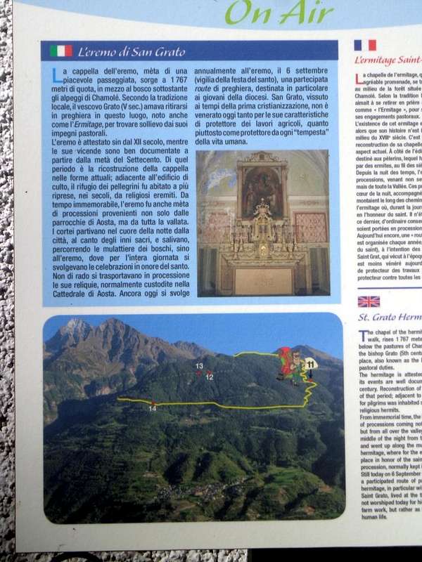
A)- But we are interested in these first two visits.. If we talk about the high area, above St. Grat Hermitage, we need to talk Alpage of Chamolé, because, even more Pila, the pin must be considered important for many walks. Located on the edge of the forest, called Bois du Jardin Public, and above a beautiful prairie, is facing North, ie above the City of Aosta. You can reach from Pila-Resort with several departures differentiated through the various paths n° 14/16/19/19A, who gather near the junction 2049 metres at the exit of the forest; a wide circle semicircular towards Southeast, past the ruins of Alpe Chanté (2114m; between the stones pell-mell piled, attention to the viper!), leads to the beautiful stone fountain just South of Alp. Absolutely not cross the great lawn! Here also comes a private road concomitant with the trails n° 19/19D/20/102, that goes from the Hermitage of San Grato (1787m; fountain, benches and wooden tables and several stone barbecue) and, overcoming the eponymous mountain pasture just behind, goes back towards South so steeply in East of Torrent Vernaillère coming to ' alp right at the fork where the trail n° 20/16 begins to Plan Fenêtre Hill (2229m) and the Vallon of Comboé. To get to San Grato using a comfortable farm private dirt road attendant with the trail n° 14Lthat, starts just above the large parking lot at the "Restaurant Lyon Noir", goes on a slight slope to the East through the forest. This is a classic walk for families, while in past centuries was the culmination of a great Popular Procession starting by Aosta, dated the entire lower hill of Charvensod by the path n° 14L/102 passing first to the tiny, renowned Shrine of Sainte Colombe (915m).
Here was honored Saint Grat, the Patron Saint of Aosta and of the whole Aosta Valley.
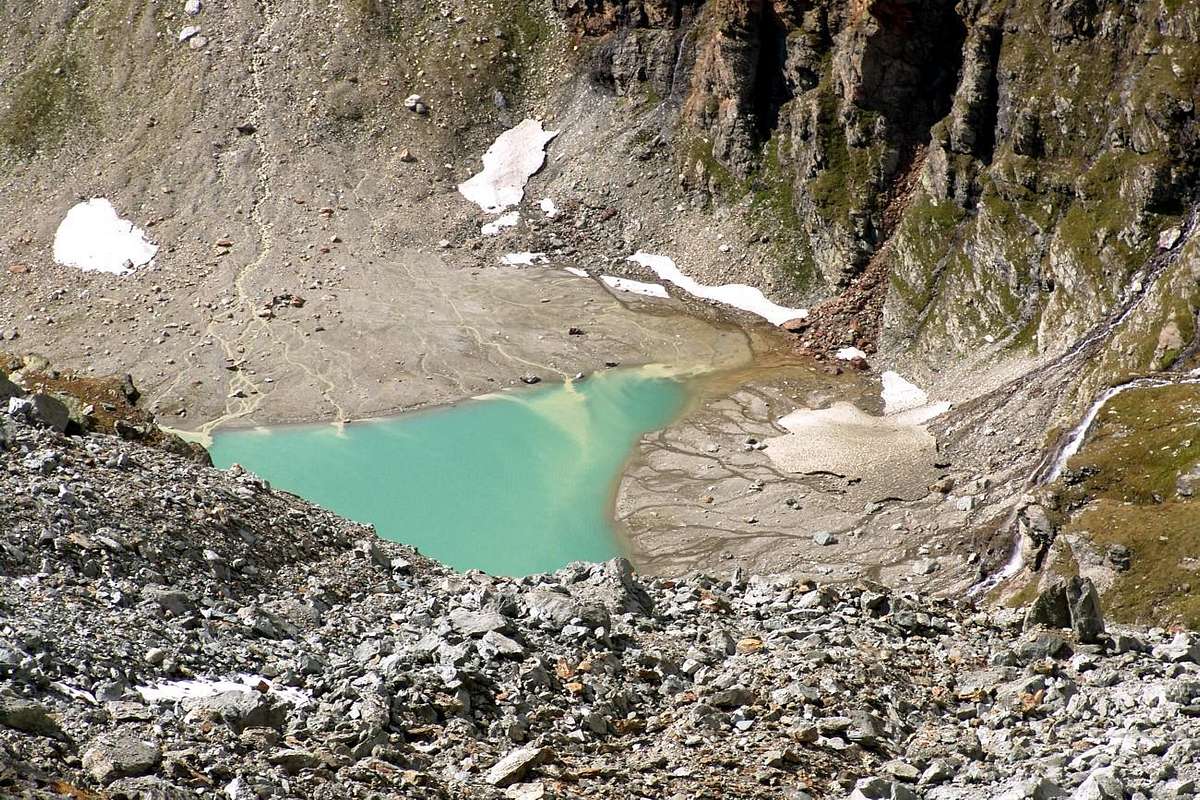
B)- While the second visit at Saint Grat Lake into the homonym vallon is a real Excursion. From Valgrisenche (1664m) he continues with reaching Mondanges the last hamlet against the Dam (1652m) and, abandoning her two ramifications on the left (South and East), he continues at first toward North up to the alternative 1661 metres, where the mute road in opposite sense, and with three narrow hairpin bends on winding road reaches the Fraction of Bonne (1.810m), near the great wall or dike's obstruction of the Dam; continuing with a long South-southeast diagonal, dominating of a 150 metres the same one, the following little Fraction of Vieux-Menthieu it is reached (1848m). To abandon to right (Southwest) instead the dirt road towards Arp Vieille and the Vallon with the same placename (prohibition of transit for the cars indicative and poster in wood "Arp Vieille") continuous and through the Main Road with a long and panoramic rectilinear impending the Artificial Dam or Lac de Beauregard surpassing an Alp 1943m under the small quota 2015 metres, the following grouping of Breyon and reaching Rognettaz Dèsott to altitude 1970/80 metres about. Here, he abandons contrarily, the Regional Road that goes down wings Villages of Surrier and Usellières to the confluence of the Doire de Valgrisenche with the Torrent Grand Alpe, to take the excavated dirt road for the Village of Grand Alpe (1988 m; also here poster with prohibition of transit for the cars); from the pastures, to the entrance of the Vallon of Saint Grat continuous to through the same one, concomitant with the path n° 13/14/HRG or High Glacial Via and climbing side by side to the torrent to reach first the Alp of Revèraz Dèsott (2153m) and just after the crossroads 2174 metres, where the same one finishes only continuing with the above quoted paths. Leaving on the left (West-southwest; distinctive little bridge in the shape of arch) the n° 13/HRG that it is addressed to the Col du Mont (2639m) to continue instead with the n° 14, that it goes up again the Vallon of St. Grat until his term immediately following its lake. Before with direction Northwest to reach the Torrent du Lac, emissary of the homonym lake and confluent of the Torrent Grand Alpe, then with address decidedly to North on the fund of the same vallon reach the small chapel (+; 2.466m), positioned on the Southern shore of the San Grato Lake (+; 2.462m; 2h'00/2h'15) and immediately below the Glacier de Saint Grat and the Col de la Sachère in North and Testa del Rutor (3486m), just in Northeast.
Come si raggiunge l'Eremitaggio di San Grato da Pila per incontrar il Santo?
A)- A noi interessano queste prime due visite. Se parliam della zona alta, sopra l'Eremitaggio di San Grato, dobbiam parlare dell'Alpe di Chamolé, perché, ancor più di Pila, deve essere considerata il perno importante per molte passeggiate in diverse direzioni. Situata al limite del bosco, chiamato Bois du Jardin Public, e sopra una bella prateria, é rivolta verso Settentrione, cioé sopra la sottostante Città d'Aosta. La potete raggiungere da Pila con diverse partenze differenziate per mezzo dei vari sentieri n° 14/16/19/19A, che si riuniscono nei pressi del bivio 2049 metri all'uscita del bosco e prima del grande prato sottostante all'alpe; un largo giro semicircolare verso Sudest, oltrepassando le rovine dell'antica Alpe Chanté (2114 m; tra le pietre disordinatamente ammucchiate, attenti alla vipera!), porta alla bella fontana in pietra subito a Sud della stessa. Non attraversate assolutamente il grande prato! Qui giunge anche una strada poderale concomitante con i sentieri n° 19/19D/20/102, che sale dall'Eremitaggio di San Grato (1787 m; fontanella, panche e tavoli in legno e diversi barbecue in pietra) e che, superando l'omonimo alpeggio subito alle spalle, risale in modo ripido con stretti tornanti verso Sud ad Est del Torrent Vernaillère giungendo all'alpe proprio presso il bivio, dove inizia il sentiero n° 20/16 indirizzato al Colle Plan de Fenêtre (2229 m) ed il Vallone di Comboé. Per arrivare a San Grato si utilizza una comoda strada poderale in simbiosi col sentiero n° 14L, che, partendo appena sopra il grande parcheggio presso il "Ristorante Lyon Noir", si dirige in falsopiano verso Est attraversando la fitta Foresta Nera di Combatissière. Questa é una classica passeggiata per famiglie, mentre nei secoli passati costituiva punto di arrivo d'una grande ed alquanto famosa Processione popolare che, partendo dalla Città di Aosta, risaliva, dalla località del vicino Pont-Suaz sulla Dora Baltea, tramite il sentiero n° 14L/102 l'intera bassa collina sopra Charvensod, passando dapprima al piccolo ma frequentato Santuario di Sainte Colombe (915 m).
Quivi veniva onorato San Grato, il Santo Patrono della Città e dell'intera Valle d'Aosta.
B)- Mentre la seconda visita al Lago di San Grato internamente all'omonimo vallone, costituisce una vera e propria Escursione. Da Valgrisenche (1664 m) si prosegue con la carrozzabile raggiungendo il Villaggetto di Mondanges ultimo contro il fronte della Diga (1652 m) ed, abbandonando le due diramazioni sulla sinistra (Sud ed Est), si prosegue dapprima verso Settentrione fino al bivio 1661 metri, dove la strada cambia in senso opposto, e con tre stretti tornanti raggiunge la Frazione di Bonne (1810 m), appresso al gran muro di sbarramento della diga; continuando con un lungo diagonale a Sud-sudest, dominando di 150 metri la medesima, si raggiunge la successiva Frazioncina di Vieux-Menthieu (1848 m). Abbandonare invece sulla destra (Sudovest) la strada poderale per l'Arp Vieille e l'omonimo Vallone (divieto di transito per i mezzi e cartello indicatore in legno "Arp Vieille") per continuare con quella pricipale con un lungo e panoramico rettilineo sovrastante la Diga Artificiale o Lac de Beauregard sorpassando un Alpe 1943 metri sotto la piccola quota 2015 metri, il successivo raggruppamento di Breyon e raggiungendo Rognettaz-dèsott a quota 1970/80 metri circa. Qui, al contrario, si abbandona la Strada Regionale che scende ai Villaggi di Surrier e di Usellières alla confluenza della Doire de Valgrisenche con il Torrent de Grand Alpe, per prendere la strada poderale per il Villaggio di Grand Alpe (1988 m. Anche qui cartello con divieto di transito per gli automezzi); dall'alpe, all'imbocco del Vallone di San Grato, continuare tramite la medesima, concomitante con il sentiero n° 13/14/HRG o Alta Via Glaciale e, salendo in parallelo al torrente, raggiungere prima l'Alpe di Revèraz Désott (2153 m) e subito dopo il bivio 2174 metri, dove la medesima termina continuando solamente con i sopracitati sentieri. Lasciando sulla sinistra (Ovest-sudovest; caratteristico ponte ad ad arco sul torrente) il n° 13/HRG indirizzantesi al Col du Mont (2639 m) continuare invece con il n° 14 che risale il Vallone di San Grato sino al suo termine subito appresso all'omonimo lago. Prima con direzione Nordovest raggiungere il Torrent du Lac, emissario del lago e confluente del Torrent de Grand Alpe, poi con svolta decisamente a Settentrione sul fondo del vallone medesimo raggiungere la piccola cappella (+; 2466 m), posizionata sulla sponda Meridionale dello splendido Lago di San Grato (2462 m; 2h'00/2h'15) ed immediatamente al di sotto del Glacier de Saint Grat ed al Col de la Sachère a Settentrione nonché alla Testa del Rutor (3486 m), situata subito a Nordest del medesimo.
Parents refers to a larger category under which an object falls. For example, theAconcagua mountain page has the 'Aconcagua Group' and the 'Seven Summits' asparents and is a parent itself to many routes, photos, and Trip Reports.