
|
|
Route |
|---|---|
|
|
31.17499°N / 7.82561°W |
|
|
Download GPX » View Route on Map |
|
|
Mountaineering |
|
|
Spring, Summer, Winter |
|
|
A long day |
|
|
PD+ |
|
|
5.4 (YDS) |
|
|
Overview
A beautiful mountaineering route on a prominent peak with amazing views of Toubkal national Park. The West Ridge naturally draws the eye when you drive into Oukaimden. The climbing is straightforward and gratifying but the committment level once on the ridge is high with no easy places to bail until you reach the Tissi Plateau. Given clear skies you will have fantastic views of Toubkal National Park for hours from Tizi n Gruden all the way to the summit. Easy access makes this a solid option if you are looking for great mountaineering close to Marrakech but away from the bustle of Toubkal.
|
 |
|
Getting There
From Marrakech self-drive or take a Grand Taxi to Oukaimden - 65 KM (1.5 hours).
In winter park by the Oukaimden Ski Lifts and hike about 4.5km up the pist (unpaved road) toward Tizi n' Eddi (spelled Tizi n' Ou Addi on Google Maps).
In other seasons you can usually drive past the ski lifts for 3 or 4 kilometers and park on the side of the pist.
Route Description
Follow the pist (unpaved road) past the Oukaimden ski slopes toward Tizi n' Eddi (spelled Tizi n' Ou Addi on Google Maps). - P2030 on Google Maps.
Cut across small valley below the pist and keeping steep rocks climbers left move up a feeder valley to Tizi n Gruden.
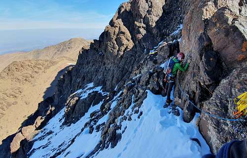
Ascend third class terrain (some kairns) to gain the West Ridge.
Circle around small dome climbers right getting to the top the dome on easier terrain behind.
Follow the West Ridge. There are two rock steps to climb directly (fifth class) and some knife edge sections that protecting with slings as necessary. There is one clearly difficult section that should be avoided climbers left.
The ridge eventually opens up to the Tissi Plateau. Here head climbers left with easy scrambling to the summit dome.
Descend by the same route or reverse the the North Face Route / North Ledge Route.

Essential Gear
Crampons, Ice Axe, Rope, Slings and possibly a small rock rack.
External Links