
Comments
No comments posted yet.
As we left the Blue Ridge Parkway turning right on to NC-128 North, we were slowed down by what seemed like thousands of road-bikers in spandex with signs pinned to their backs announcing their “assault” on Mitchell. None of us had never heard of the “Assault on Mitchell” bike race, and so we had a good laugh at what we deemed an absurd name.
At this time in my life I was living in Arlington Virginia, and working in the Washington DC area as a Web Developer. I was fortunate to have a wonderful group of likeminded friends and together we enjoyed hiking in the nearby forests regularly. We spent many weekends, and the occasional “sick-in” (our word for calling in sick to work and then going out hiking for the day) in the George Washington Forest, as well as in and around Shenandoah National Park. The Old Rag Mountain hike and the hike from Shenandoah park boundary to White Oaks Falls were two regulars and favorites of ours.
Looking to broaden our hiking horizons one friend suggested we head down to North Carolina for a few days and tackle the then privately own Grandfather Mountain. It is over 400 miles from Northern Virginia to Boone North Carolina, and another 18 miles to Grandfather Mountain. Our group of three made the drive on a Thursday evening after work. Outside of Boone we happened on a concealed, empty lot being prepared for construction, where we caught a few hours of sleep before carrying on to our destination the next morning.
At Grandfather we found stunning scenery along with marvelous ecological diversity, and we enjoyed a full day of hiking, which involved more than one peak, and even multiple ladders up the steepest sections. We also walked the mile high swinging bridge, America’s highest suspension footbridge, over to Linville Peak.
That night we camped out in the surrounding mountains, and the following morning Parley suggested we drive to Mount Mitchell the state’s highest point. We hadn’t planned on it, but we had the time and so we all agreed.
Heading further away from Virginia we followed the Blue Ridge Parkway about fifty miles to the turn off to Mount Mitchell often scoffingly joking at the idea of driving to the top of a mountain, which we were nevertheless excited to see. As we made the hour and a half journey we enjoyed the remarkable views the parkway offered, and I was impressed with the engineering of the road itself. Turning right on to NC-128 we encountered the assailants, who we incorrectly assumed where simply on a moderate bike ride up the four and half miles of NC-128 to the summit parking lot. Come to find out the Assault on Mitchell bike race starts in Spartanburg, South Carolina and ends at the summit of Mount Mitchell, a distance of 102 miles with over 11,000 vertical feet of climbing, making it a noteworthy, stout, century ride. According to Wikipedia, “most riders finish in less than 12 hours; the leaders finish in under 6 hours”.
Weaving through the spandex clad attackers eventually we drove past the park headquarters and on to the parking lot just below the summit passing the State Park restaurant on the way. Miraculously on what is probably the most congested day of the year on Mt. Mitchell we managed to obtain parking.
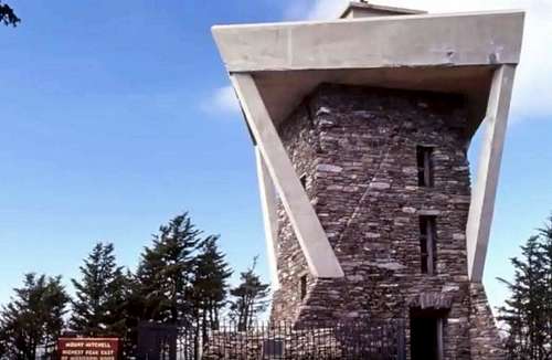
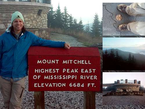
From the parking lot to the summit is approximately a quarter of a mile stroll on a paved trail to a viewing platform. Reaching to 6,684 feet above sea-level Mount Mitchell is not only North Carolina’s highest point but is also the highest peak east of the Mississippi river.
I have since visited Mt. Mitchell for a second time, camping on the mountain itself October 6, 2019, and hiking to the summit the next morning. Without the bike racing crowds, Mitchell is a splendid mountain with amazing 360 degree views.
On my first visit the summit platform was much taller and better looking, being bricked with natural rocks and topped with a square concrete platform, as compared to the shorter rounder platform of today with it disproportionally, and extra-long, curved and gently sloping accessibility ramp.
Due to the hurried and crowded nature of my first visit I over looked the grave site of Elisha Mitchell, a geologist, explorer and Presbyterian minister for whom the mountain is named. The grave resides next to the viewing platform on its south side. In the 1830s, his measurements proved the 6,684-foot peak was the highest in the East, surpassing Grandfather Mountain sixty miles northeast. As a result of questions about Elisha’s elevation measurements of the mountain, he was on a return expedition in 1857 when he fell to his death. Originally buried in nearby Asheville his body was interred in a tomb on the mountain in 1858.
Want more details? I have published a book about my journey to the highest point of every U.S. state. The book, All Fifty: My Journey to the Highest Point of Every U.S. State, is available on Amazon.com.