
-
 8097 Hits
-
 87.31% Score
-
 24 Votes
|
|
Mountain/Rock |
|---|---|
|
|
28.33483°N / 16.86255°W |
|
|
Hiking |
|
|
Spring, Summer, Fall, Winter |
|
|
3287 ft / 1002 m |
|
|
Overview
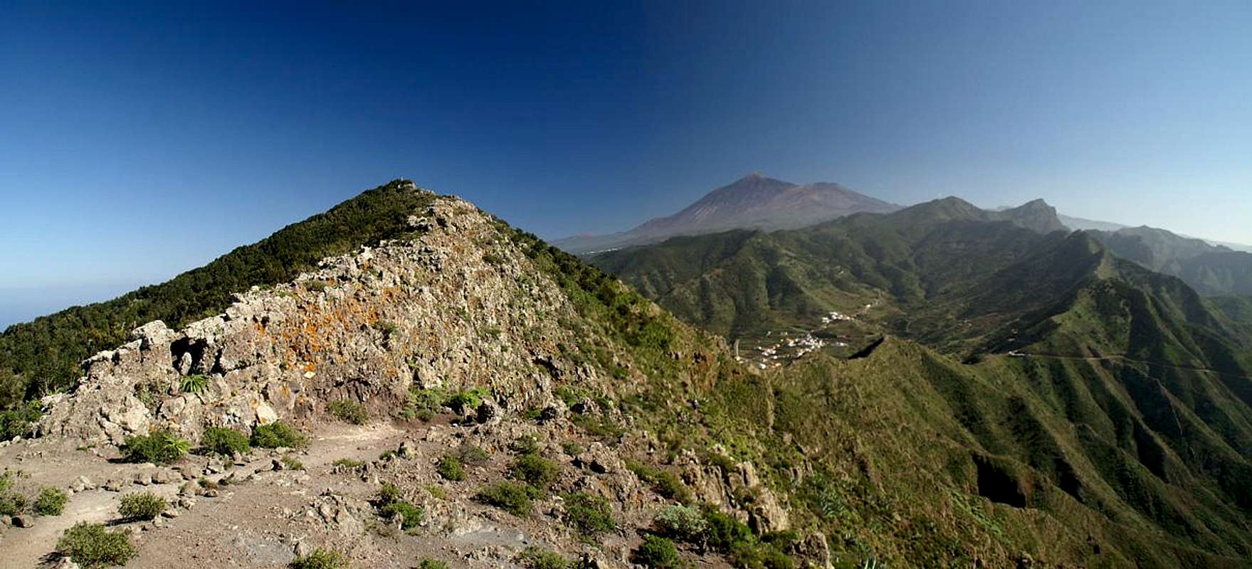
 Baracàn, Teide, Pico Viejo and Cruz de Gala Baracàn, Teide, Pico Viejo and Cruz de Gala |
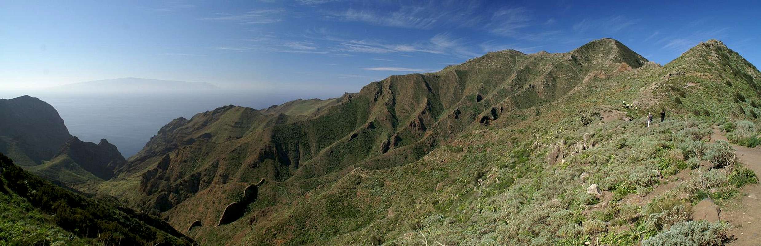
The Teno mountain range in the north-west of Tenerife is famous for its profound gorges as well as its knife-edged ridges. While there are a lot of named peaks and rocks, most of them are mere highpoints on one of the many ridges. There are only a few mountains which deserve the name, like Cruz de Gala, Montaña de las Rosas or Baracàn. Baracàn is the highest summit of the north-westernmost subgroup of the Teno Range and presides over three ridges which separate the gorges underneath. The traverse from the village of Teno Alto in the north to the Tabaiba pass is one of the most picturesque ones of the island. Unfortunately it also is one of the most popular ones, mainly due to the fact that the Tabaiba Pass is the major lookout on the road between Buenavista del Norte and the extremely popular village of Masca.
Baracàn certainly is not among the higher mountains on Tenerife but nevertheless it affords great views into the Barrancos underneath and towards the volcanoes to the west of Teide. Moreover, on a fine day the island of La Gomera is just a step away. All three ridges, which lead to Baracàn, can be climbed but the most beautiful one is the steep south-ridge, which runs up from Tabaiba Pass. There are numerous rocky towers on the ridge and the path winds through them always keeping very close to the top. It turns away from the ridge only in its topmost part, running through the Baracàn west face. The north ridge, which starts near the village of Teno Alto, is much easier but offers the better views, especially the ones towards the north coast and the neighbouring islands.
While both ridge climbs are rather short affairs which don't cover much elevation gain, you can also climb Baracàn starting from the north coast near Buenavista del Norte. This way you gain about 1000m in altitude, following the steep Camino de los Riscos through the impressive Barranco de la Torre to the Teno Plateau, to Teno Alto and to Baracàn reaching the summit via its north ridge.
|


Getting There
  |
From the North
Take the motorway TF5 to Puerto de la Cruz and Los Realejos and follow the coastal road (still TF5) to Icod de los Vinos. There the road turns into TF42, heads through Garachio and Los Silos and finally reaches Buenavista del Norte. Here turn onto the naroow TF436, direction Masca and Santiago del Teide. For Teno Alto take a side road right behind the village of El Palmar. For the Tabaiba pass go straight on through Las Portelas.
From the South
Take motoway TF1 to its end at Adeje. There either follow TF82 through Guia de Isora to Santiago del Teide or follow the coastal road TF47 to Los Gigantes and TF454 to Santiago. The latter route takes much longer but offers great coastal views. From Santiago take TF436, through Masca until you reach the Tabaiba Pass. For Teno Alto drive straight on through Las Portelas and take a right turn at Los Cuevas del Palmar.
Red Tape
 |
There is no actual red tape in the Teno mountain range. However, the land is used for farming and belongs to the locals of the area. They have agreed to hiking trails being created which traverse their fields but request that hikers stay on them. Also, any gates should be left the way you found them. The ridge of Los Pajares has only one gate right at the beginning and is only used for extensive goat grazing.
Accommodation
Of course you can find a lot of hotels, fincas and casas on the island which you can book from any travel office. The closest tourist locations are at Los Gigantes and Buenavista del Norte. The Teno mountain range can be easily reached from the towns in the north as well as the ones in the south and simply requires a 1h - 2h drive. In the villages of the range you can find inns where you can find a place to eat and maybe even to sleep. You should not count on the latter, however. Camping is not allowed in the Teno Range.Weather Conditions
There are several sites on the web which give you information on the weather on Tenerife. The following table shows data for Puerto de la Cruz on the north coast.| Month | Jan | Feb | Mar | Apr | May | Jun | Jul | Aug | Sep | Oct | Nov | Dec |
| Avg. day temp.[°C / °F] | 19 / 66 | 19 / 66 | 20 / 68 | 21 / 70 | 22 / 72 | 23 / 73 | 24 / 75 | 26 / 79 | 26 / 79 | 24 / 75 | 22 / 72 | 20 / 68 |
| Avg. night temp.[°C / °F] | 13 / 55 | 13 / 55 | 14 / 57 | 14 / 57 | 16 / 61 | 18 / 64 | 19 / 66 | 20 / 68 | 20 / 68 | 18 / 64 | 17 / 63 | 14 / 57 |
| Water temp.[°C / °F] | 19 / 66 | 19 / 66 | 19 / 66 | 19 / 66 | 20 / 68 | 20 / 68 | 22 / 72 | 23 / 73 | 22 / 72 | 22 / 72 | 21 / 70 | 20 / 68 |
| Rainy days | 10 | 7 | 8 | 4 | 3 | 2 | 1 | 1 | 3 | 5 | 7 | 9 |
The Canarian Islands (as well as Madeira) are located in the trade wind zone. You almost always encounter northeastern winds which carry a lot of humid air. Being forced to climb to higher altitudes this moisture condenses into clouds. This in return means that most of the time the northeastern part of the islands is covered in clouds from altitudes of 1000m through 2000m. The Teno and Anaga Ranges often are covered in clouds, though mostly along the north coast. It is a lucky day when there is no fog on the Teno plateau and on Baracàn. Also, very often fierce winds sweep the summit.
Maps & Books
Out of the multitude of maps and books I have been using the following. However, so far I have not found a good hiking map of the island. The one posted here is ok but shows only a fraction of the marked hiking trails. The guidebook is excellent but be careful if you do any one of the suggested "variations" to the tours described therein. The variations are described in a few words only and you might get the wrong impression of their quality.- Maps
- Teneriffa
Kompass Map WK233
Kompass Verlag
ISBN: 3-85491-038-X
Books
- Teneriffa, Tenerife
K.Wolfsperger, C. Ade
Rother Walking Guide
Rother Verlag
English - ISBN: 3-7633-4809-3
German - ISBN: 3-7633-4016-5