
-
 31049 Hits
-
 90.13% Score
-
 31 Votes
|
|
Route |
|---|---|
|
|
37.99806°N / 107.62222°W |
|
|
Hiking |
|
|
Spring, Summer, Fall |
|
|
Half a day |
|
|
easy |
|
|
Overview

Bear Creek
The Bear Creek Trail is a very spectacular trail just off Highway 550, south of Ouray, Colorado. The Bear Creek Trail now stands as a monument to the determination and perseverance of Colorado's nineteenth century miners. It was originally built in the mid 1870s, and rerouted to its present location 20 years later. The old trail follows an unlikely route up Bear Creek, through a canyon that is so rugged it is often impossible to reach the water without ropes. Miners were forced to dynamite horizontal shelves into the rock in order to traverse the vertical walls. The trail passes by the remains of two hundred year old mining camps along the creek.
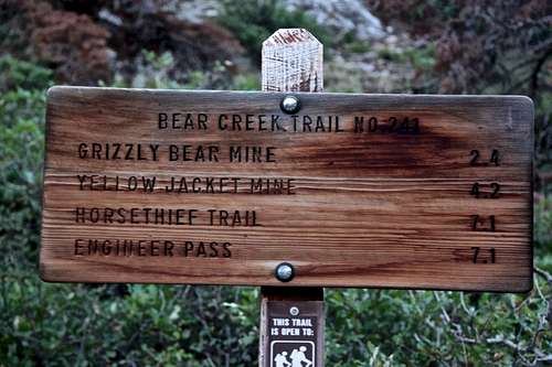
Distance: It's an in and out trail, so the distance depends how far you decide to go - anywhere from a few miles to 14.2 miles round trip if going all the way to Engineer Pass. Most people turn around either at Grizzly Bear Mine (2.4 miles up = 4.8 miles round trip, or Yellow Jacket Mine (4.2 miles up = 8.4 miles round trip). The most spectacular and unique section is up to Grizzly Bear Mine, higher up beautiful alpine scenery as in many other places in San Juan Mountains. You can have someone to pick you up at Enginner Pass provided you have a high clearance 4 WD vehicle.
Elevation at trailhead: 8,460 ft.
Elevation at Grizzly Bear Mining Camp 9,900 ft.
Elevation at Yellow Jacket Mining Camp 11,100 ft.
Map: Ouray, Ironton USGS
Vicinity: near Ouray
Season: Midsummer through Mid-fall. The trail is generally covered with snow from mid-November through June.
Bear Creek Trail provides an easy access (maybe long, but on a nice and very scenic trail) to several peaks in the area. I would like to mention at least Engineer Mountain, Darley Mountain, Cow Benchmark, Wildhorse Peak among a few. Most people choose to drive higher up on the 4WD roads, but many like long approaches to peaks. Although the trail is very popular, most hikers tend to stay lower on the trail and do not venture past the mines. I met only a few people lower down on the trail, and found solitude past 4.2 miles Yellow Jacket Mine.
![The trail starts]()
Trailhead
![On the top of the tunnel]()
Parking Lot
From Ouray, drive 2.3 miles south on US Highway 550 (=Million Dollar Highway) to where the road passes through a small tunnel. The trailhead is on the right (=west) side of the road immediately beyond the tunnel. It is well marked. There is a small parking lot on the west side of the road, and a larger parking lot on the right side of the road.
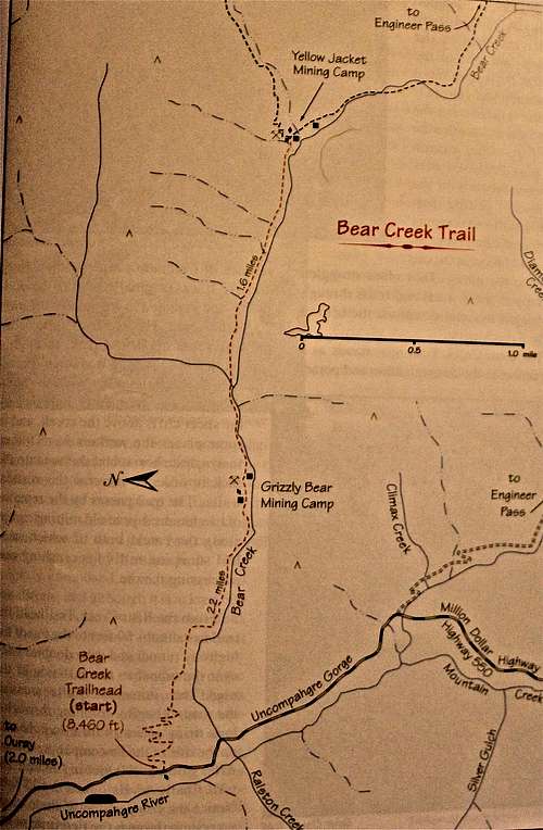 Illustration of the trail Illustration of the trail |
Hike can be done either as in and out hike from The Bear Creek Trailhead, or from the top of Engineer Pass and ending at the Bear Creek Trailhead. A 4WD vehicle is required, however, to get to Engineer Pass. to reach the pass drive south of Ouray for 3.6 miles where you will see a sign on the left marking the beginning of the Alpine Loop. Engineer Pass is 9.8 miles up this 4WD road.Of the four different Bear Creeks found in the western half of the San Juan Mountains, the one that drains into the Uncompahgre Gorge a couple of miles south of Ouray could well be the most spectacular. Although the creek bottom itself is far too rugged to follow, miners during the late nineteenth century were not deterred and constructed a trail into the upper reaches of the drainage. In so doing, they built one of the most improbable mountain trails in the Colorado Rockies. The hike is designated as a National Recreation Trail. |
 |
Getting There

Trailhead

Parking Lot
Engineer Pass TH - you need a 4WD vehicle to reach this pass, and the pass climbs to 12,800 feet. The start of the TH is located behind the sign for Engineer Pass (between Darley and Engineer Mountains). The road to Engineer Pass from Ouray side is rough, many people choose to drive up from Silverton. It is longer if you start at Silverton, and you have to cross Cinnamon Pass on your way to Engineer (incredible scenery), but less demanding on your car. You can make a nice loop and continue onto Lake City.
The Alpine Loop is very popular 4WD destination, expect traffic during the summer (it is open only for about 4 months a year, closed for winter - information about closure of roads here). It is well signed.
Route Description
 Distance chart Distance chart |
 Bear Creek Trail Bear Creek Trail |
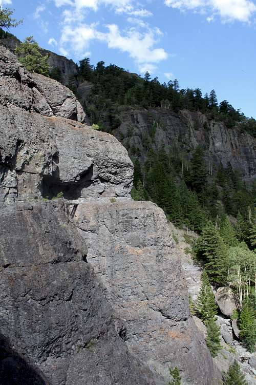
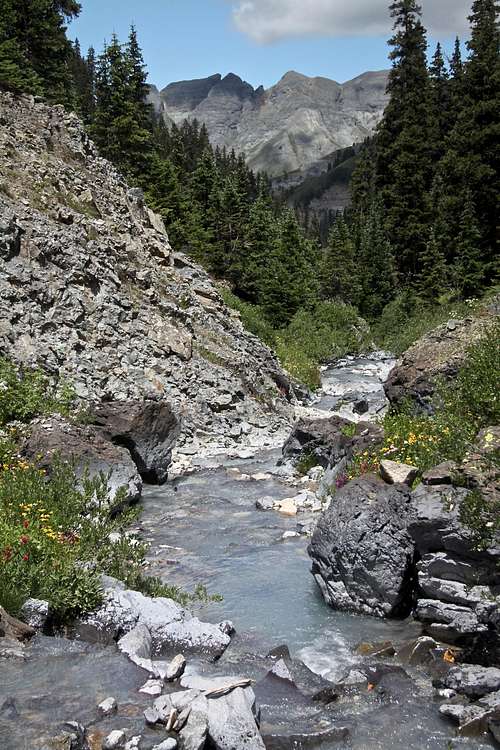
From the trailhead, the Bear Creek Trail crosses over the road by way of the top of the tunnel. It then begins climbing up a lengthy series of switchbacks along the east wall of the Uncompahgre Gorge. After gaining 900 feet in 0.9 mile the trail finally levels out at 9,400 feet. Notice the composition of the rock as you climb through the first mile of the trail. This is the Precambrian Uncompahgre Formation, which is comprised primarily of slate and quartzite. The shiny black slate is particularly interesting. It fractures into thin, brittle sheets that crackles like glass when you walk over them.
The trail levels out at the top of the Uncompahgre Formation and begins to turn south towards the Bear Creek. Also at this point it begins to skirt along the base of the volcanic cliffs of the San Juan geologic formation. This thick, gray colored layer of tuff is only about 30 million years old, much younger than the underlying slate and quartzite. It is also very crumbly and easily eroded.
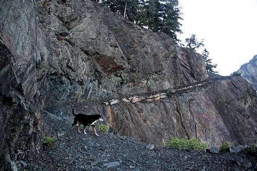
The miners were forced to blast a narrow path into the side of the vertical wall a hundred feet above the canyon bottom. There are no published statistics about people or animals falling into the canyon here, but the trail has been in use over a hundred years and I would be surprised if there has been never been an accident.
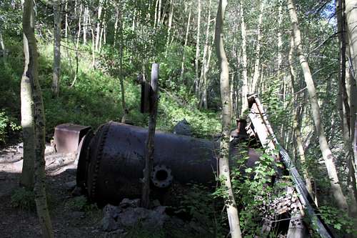
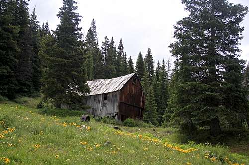
2.4 miles after leaving the trailhead yo will pass by the wreckage of the Grizzly Bear Mining Camp. Bear Mine reached its peak production in the mid 1890s.
From Grizzly Bear Mining Camp the trail meanders along the Bear Creek for another 1.8 miles to the Yellow Jacket Mining Camp. The Yellow Jacket Camp was never as big as Grizzly Bear, but is better preserved today. The Yellow Jacket Mine reached its peak production in 1915, a decade after Grizzly Bear Mine closed.
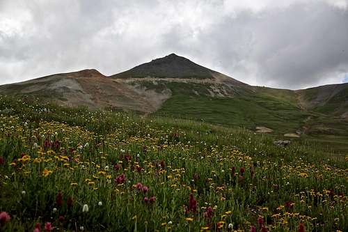
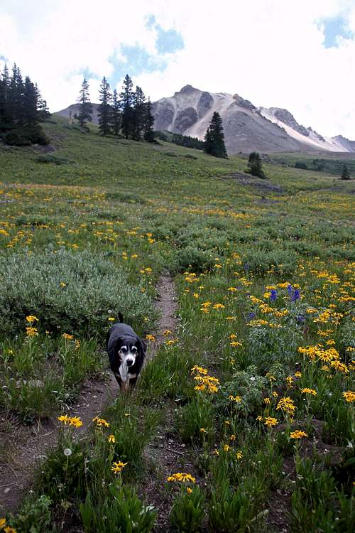
Bear Creek trail splits into two branches 0.1 miles past Yellow Jacket Mine. Right (=southern) branch continues to Engineer Pass. This is the more travelled branch, which follows the Bear Creek though a high alpine meadow. Wildflowers in July and early August are amazing on this section of the trail. The left (=northern) branch connect higher up with Horsethief Trail. This branch is less travelled, and provides access to Cow Benchmark and even to Wildhorse Peak.
If you continue further up, you will reach Engineer Pass Trailhead - alpine tundra environment. You will have nice views of Engineer and Darley Mountain. Expect to find jeeps at the Engineer Pass and as mentioned above, you can do this as a one way hike if you leave one vehicle at the Engineer Pass TH. Otherwise, you have to hike back and enjoy a nice 14.2 mile outing.
Bear Creek Trail Photo Guide
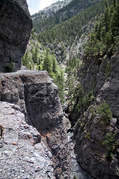 Scenery on lower section of Bear Creek Trail Scenery on lower section of Bear Creek Trail |
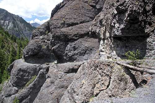 Exposed trail below Grizzly Bear Mine Exposed trail below Grizzly Bear Mine |
 Grizzly Bear Mine Grizzly Bear Mine |
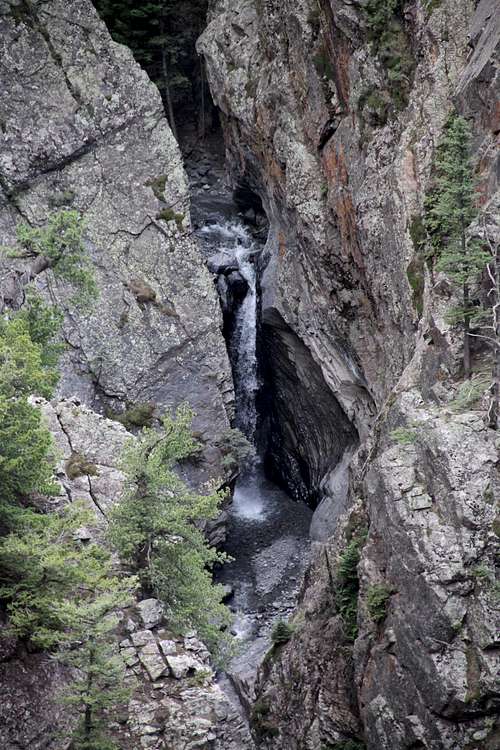 Waterfalls falling into Bear Creek Waterfalls falling into Bear Creek |
 Crossing Bear Creek Crossing Bear Creek |
 Yellow Jacket Mine Yellow Jacket Mine |
 Engineer Mountain Engineer Mountain |
 Darley Mountain Darley Mountain |
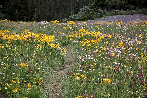 Wildflowers Wildflowers |
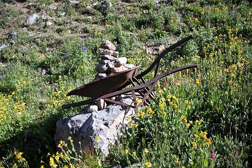 Interesting Cairn Interesting Cairn |
Essential Gear
Good hiking boots. Trekking poles may be useful. Rain gear (July and early August afternoon thundershowers). Camera - it is very scenic. This trail is great for trail running. Beautiful wildflower fields higher up on the trail in July and August.
 |
 |
 |
 |
 |
External Links
Bear Creek TrailAnother nice site with information about Bear Creek National Recreation Trail
Alpine Loop information - nice information about 4WD roads and access of the Upper Bear Creek TH from Engineer Pass (the road from Ouray side is rough).
