Introduction
Ever had a perfect day ruined by a pompous blockhead? A pretender? A bloke proud of his undeserved title? I had recently, when I climbed Gingilos and Volakias on Crete, two mountains, towering right above Crete's main natural attraction, the
Samaria Gorge. Yes, the day was perfect: perfect weather, maybe a little to windy, a perfect pair of mountains to climb, a route that promised to be exciting with lots of trailless climbing, perfect views to be expected. In the end we had all this as you will see by the photos but the day was marred by our acquaintance with Dimitrios, Greek guide of a German hiking group, whom we met on the first and most difficult summit, Gingilos.
(Explanation of the play of words above:
Bergwacht means "mountain watch" in literal translation, the guys who will tell you about mountain conditions, who organise rescue missions and so on. I naturally have a lot of respect for these guys.
Wachtmeister is a job title, mainly used by the German police for their officers. They come in Wachtmeister, Oberwachtmeister and Hauptwachtmeister and while I do have a lot of respect for these guys, too, the name has become a synonym for believing in the title rather than in the actions or knowledge of the officer. Don't dare to call them by their name without their title!)
Mountaineering on Crete
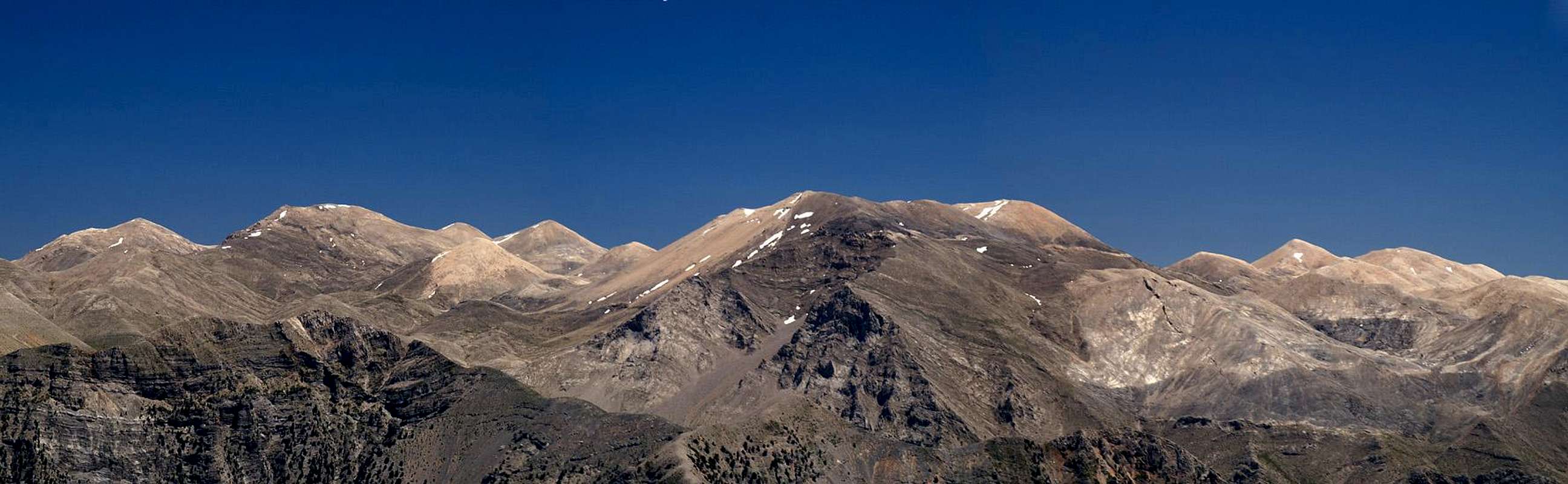
The Lefka Ori Range, Crete's White Mountains as seen from the summit of Volakias |
Crete is the fifth largest island of the Mediterranean and while it is not the highest one, it contains three mountain ranges reaching 2000m and more. All three ranges are made up from limestone, which in a geological timeframe is rather old and thus already quite eroded. You find the typical karst formations with caves, gorges and collapse zones. All the summits have rounded tops, which look easy to climb from afar. However, going on the sharp edged limestone requires good equilibrium and often the access routes are very long. Moreover, the terrain is nearly featureless so that orientation can become a serious issue.
There is one exception to this rule, mighty Gingilos in the Lefka Ori range (the White Mountains) in the west of Crete. It is certainly not the highest of mountains - it barely passes the 2000m threshold - but its north and east faces rise out of the Samaria Gorge for more than 1000 vertical metres. The mountain is made up of grey main Dolomite and thus also is an exception from the surrounding reddish white limestone peaks. In fact the Gingilos rock is far more solid than the stuff of which its vicinity is made which accounts for its dramatic aspect when seen from the north-eastern side.
Gingilos has a big brother, Volakias, located to its south, which is made up from huge limestone blocks. It is far less impressive in aspect but the far better lookout peak of the two. The path to its summit is marked - but very sparsely - and you'll need a good sense for orientation to reach its top. While Gingilos is by far the most popular mountain on Crete - you might add that it is probably the most difficult one as well - Volakias doesn't see as many visitors - you can count on having the summit for yourself.
Love at First Sight
![Volakias (2116m), Gingilos (2080m)]() Volakias, Gingilos and Psilafi (far right)
Volakias, Gingilos and Psilafi (far right)
On our first day on Crete we decided to climb Melindaou, an easy 2000er located to the east of the Samaria gorge. It shares its trailhead, the plateau at Xyloscalo, which also is the entry point to the gorge itself. When you look into the Samaria Gorge from Xyloskalo your attention is immediately drawn to it western side, where Gingilos rises out of the depths with a classic dolomite east face. To see this mountain means wishing to climb it. Moreover our guidebook described the climb combined with the one of Volakias and since accessible mountains are rare on Crete and so the decision was easily taken.
During that day we climbed Psahi and Mavri (prior to Melindaou), two lesser summits opposite of the Volakias - Gingilos pair, and thus had perfect views of the couple, confirming the decision. The climb through the couloir to the north of Gingilos, in which the Samaria Gorge end on its western side, appeared to be demanding however. Drawing analogies from the Dolomites we expected an endless scramble across unstable scree slopes. Hopefully the upper part would be more solid but from our vantage point this part of the route could not be seen. We braced for some suffering. Suffer we did but quite differently than we expected.
![Volakias and Gingilos]() Samaria Gorge Samaria Gorge | ![Gingilos East Face]() Gingilos Gingilos | ![The Kallergi Hut]() Kallergi Hut Kallergi Hut |
Hiking Groups! A Sign of Things to Come
![Looking into the wide couloir]() The Ascent route through the Couloir between Gingilos and Psilafi
The Ascent route through the Couloir between Gingilos and Psilafi
Living about 60km to the north-east of Xyloskalo, we had to drive for 90 minutes to get to the trailhead. To avoid the tour coaches on the narrow and winding streets you have to be quite early but still we arrived only at 9 a.m. and the first hiking groups were already preparing for their descent into the gorge. The parking lot was already crowded and we had to take the secondary one. A quick preparation, - and we headed of towards Xenia hut, a small building overlooking the Samaria Gorge, where the ascent trail starts. It zig-zags along the lower slopes of Psilafi, the Gingilos' northern neighbour. As it turned out, the trail was very well trodden, though at the time of our start only one other couple - British - was following us. But soon afterwards a large German group started following us - and ahead of us - another large group - also Germans as we found out later - headed up the slopes.
Some days climbing doesn't come easy with us - the boots won't fit, an additional sweater is required, it gets too hot and you have to get on your shorts, etc. This was one of these days and the British couple soon caught up with us and passed. They weren't very well equipped - sneakers and no backpack with only one water bottle among them to share. Not the equipment for one of Crete's more difficult mountains. In the next switchback the trail was buried under a landslide and they had quite some problems to struggle up the short trail-less passage to regain the path above. In the end we passed each other several times, mostly because we took turns to shoot photos of the Gingilos north face whenever we came close to the edge were the Psilafi slopes suddenly drop into the couloir, which heads up from the Samaria Gorge towards the saddle between the two mountains.
Hoodoos, Arches, Springs
![Deamon Arch]() Deamon Arch
Deamon Arch
Finally we reached a shoulder in the Psilafi Slope where the path grew level, then traversed into the couloir. Psilafi is composed of very brittle rock and here in the couloir several impressive hoodoo-like towers bear witness. We stepped through an arch, called Daemon Cave and passed between the towers to reach the spring of Linoselli in the middle of the couloir. Our Brits were left far behind, obviously admiring the hoodoos (much longer than we did).
Now for the ascent: instead of the expected scree scramble a perfectly maintained path awaited us, leading in endless switchbacks up to the saddle. Up there the second hiking group was getting along but they seemed to be very slow. Everybody else in the couloir closed in on them. Halfway up to the saddle suddenly a fierce gust of wind from the north-east almost knocked me over. And from that moment it increased as we headed higher and higher.
In the saddle half of the hiking group was huddling behind the rocks to keep out of the wind. The other half was already 100m above us in the Gingilos north face, progressing ever more slowly. We took some photographs, pulled on additional sweaters and followed in their tracks.
Exposure
Psilafi as seen during the ascent to Gingilos. No exposure here I was too busy bracing against the wind. |
What followed was the most difficult part of the climb. We missed the right track and found ourselves in the upper reaches of the Gingilos north face. There were occasional cairns, indicating that we were not the only ones having ventured here but the fierce gusts of wind together with the exposure on the face made the climb quite uncomfortable. And you always have to remember that this is a Karst area, where suddenly crevices block the way or a deep hole in the ground bears witness of a collapsed cave. One of these latter can be visited in the Gingilos north face, profound by more than 100m and with a width of roughly 10m. There are "fences" around it but you wouldn't trust to lean your weight against these fences.
Anyway, we took the wrong turn and passed the cave on its eastern side and sidestepped along narrow ledges eastward. Every now and then a chimney would lead us to the next ledge, which again would lead us eastward, always keeping us right above the abyss. After three or four of these ledges a large (but steep) chimney led back to the Gingilos wets face, which is formed by large slabs, tilted at about 30 - 35. Wind exposure was less here as well and we could take a deep breath before going any further. This is, what obviously the hiking group ahead of us had also done - they were now in reach and we figured that after 15 more minutes we would have passed them. But no - we didn't count on Mr. Dimitrios.
Adopted!
![Adopted!]() Adopted
Adopted
The western side summit was easily reached. It is round-topped and sports a huge cairn on top. Many people turn around here leaving the main eastern summit to the more adventurous ones. The Gingilos summit area is a huge collapse area. The real summit must have disintegrated by a collapsing cave, so that today the area is crater-like. This crater is a veritable labyrinth of rocks, very hard to orient in but rather easy to hike / climb through. The rock is solid and very rough on the surface. As long as you can keep your equilibrium friction will get you almost anywhere. However, don't touch the rock with your hands. The rough surface is sharp-edged; two or three firm grips will leave your fingers bleeding.
![The summit area of Gingilos]() The devastation zone on the summit of Gingilos
The devastation zone on the summit of Gingilos
Through this devastation zone our path led. It must be said that the path is perfectly marked - orientation is only a problem for those who lose it. We quickly caught up with the hiking group who were climbing along at snail speed. After a minute it became evident that their guide was the one, who didn't progress. His team wasn't experienced and all were picking their steps ultra carefully. There wasn't much room and we didn't want to follow a different route. So we waited for some time but finally a passable side route opened. I was just about to pass, when the guide called me back. I shouldn't pass because he was from the Bergwacht (mountain watch) and he had to check the path for holes in the ground.
I was dumbfounded and fell back. I simply forgot to pass until the opportunity was gone. We snailed along and I was fuming. With every slow step my mood got darker. When we stepped out on a small balcony, Judith picked the guidebook from our pack and we started to consult it. Forget the summit - only 200 horizontal and 30 vertical meters were missing - we could cross over to Volakias right away. "Don't use that guidebook! It contains errors! You can come with us." Again he fooled us into following him. Yes that guidebook is far from perfect but it does not contain errors - it just skips the most interesting passages.
"Looks like we have been adopted". Judith can be quite shortspoken.
Come to think of it afterwards - we missed the best part of the climb to Gingilos. Alone, we would have enjoyed scrambling amidst the rock labyrinth. This way we had to wait for several eternities (one at each large step) until we reached the summit. The group was enthusiastic - complimenting each other on the successful climb, hugging and embracing each other. All we did was get away from them - shoot two or three pictures and return the way we had come. I was still so angry that I missed my way twice before returning to the western summit. I would have enjoyed that as well but my frame of mind was quite disturbed now.
Crossing Over
![Volakias]() Volakias as seen from the Gingilos western summit
Volakias as seen from the Gingilos western summit
"Cross over the slope to the saddle and climb the remaining 120m to the Volakias summit." - The guidebook was very shortspoken as well. We stood on the western summit and discussed where this crossing over would have to take place. We were some 150m above the saddle between Gingilos and Volakias and there was no path in sight. From the saddle a short trail led to a spur coming down from Volakias but that was all we could see. Speak about detailed descriptions!
I imagined to see a cairn south of the summit plateau and we went over there. With some imagination you could sense a path down there and lacking another possibility we started to descend. As long as we were on Gingilos Dolomite the going was ok but soon the rock made way for Volakias limestone and scree fields followed block passages, with thorny bushes in between. It was no fun to descend the south slopes but at least they weren't too steep. Hoverer, "crossing over to the saddle" took the best part of an hour.
The small path, which we had seen on the saddle from above had spawned a brother path, one lading to the western, one to the eastern part of the spur. We decided on the western one - and (thanks to Murphy's Law) we picked the wrong one. We ascended the spur like we had descended from Gingilos: freestyle fashion. The preliminary goal was a small col on the spur, which we reached after some heavy scrambling. Up there we saw that the western path wouldn't have been much better but that a perfect trail would have led up the centre of the spur directly.
From here on we were on safe ground again. Occasional cairns led the way, a steep but easy scramble towards the Volakias summit. Only right beneath the top we lost any sign of the path and took the back way to the summit, i.e. we headed west and took the ultimate west ridge to get on top. The wind was fierce still but not as bad as it had been on Gingilos. We huddled behind some of the huge summit rocks and took our lunch.
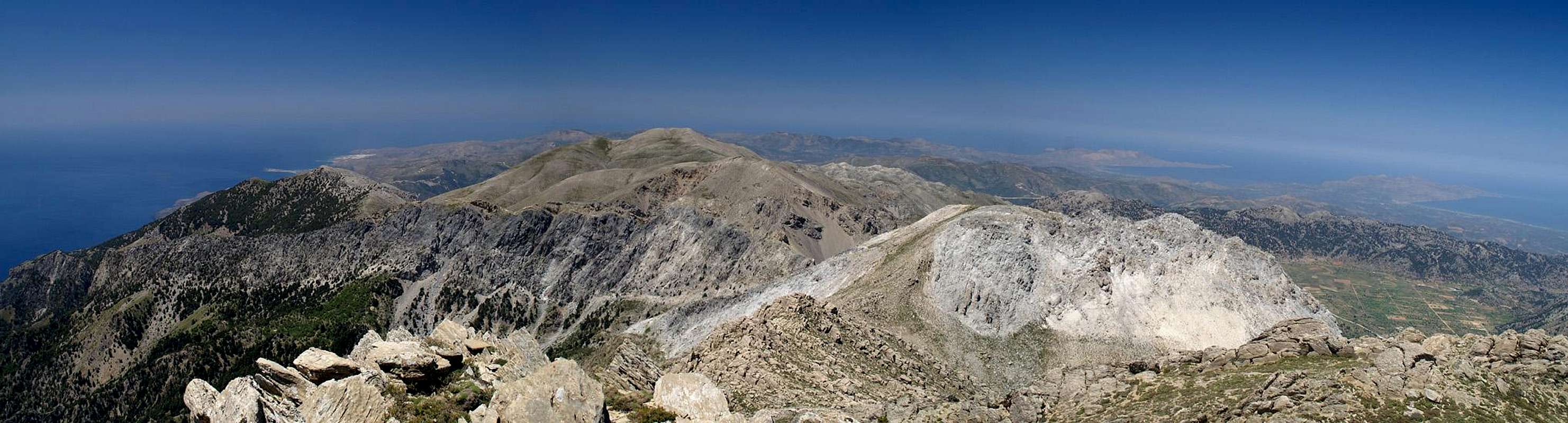
Summit view west and north from Volakias |
I'm a quick luncher and I took off immediately afterwards to explore the area. Lots of beautiful mountain flowers, a side summit (which looked higher than ours but which didn't have a summit column), even a golden eagle overhead! Views were as good as they can get on an island - three coasts visible directly, the fourth hidden behind the limestone desolation of the highest mountains of the Lefka Ori. I was at peace with the world again.
The Real Adventure - Returning to Base
![Gingilos seen during the descent]() Gingilos during the descent from Volakias
Gingilos during the descent from Volakias
The guidebook advised us to return from Volakias the way we came, then to cross over (again!) the western slopes of Gingilos to get back to the ascent couloir (and saddle). The first part was easy - much easier than ascending since I had my GPS track to help us. The second part required guesswork. Where do we start? Is there a path? What do we do if there isn't?
To cut it short: There must be a path but we only found the start and end of it. In between we were back, freesyling again. However, this time things were not quite as easy as before. The Gingilos west face is composed of huge slabs, interspersed with crevices, profound enough to lead you places you don't want to go. Instead of keeping our elevation we were forced to climb higher and higher. And suddenly - a huge doline - a collapse zone right beneath our feet.
On its far side we could distinguish a cairn - our direction was right but how to get there. Hop from rock to rock right into the doline and struggle back out on the other side. But unfortunately there were more collapse craters ahead of us and we really had to struggle. For me it was almost ok but Judith with her much shorter legs was having problems. Hop, hop - scramble, hop. The cairn didn't get any closer. Hop, hop. And now we were right underneath it. Back and climb up again. Finally!
The remainder was a quick descent to the saddle - quick in my case anyway since I had gotten used to all the hopping. Judith was much slower but finally she also made it. The saddle was still very wind so we hid behind the rocks again. A German family with two kids, 5 and 8 years old, came down from Gingilos. I was amazed. How on earth can you hoax kids into climbing 1000 vertical meters? They were tired but obviously still quite happy. Dad was carrying all the stuffed animals but the kids were climbing on their own. Wow!
![Between Volakias and Gingilos]() Melindaou Melindaou | ![Psilafi]() Psilafi Psilafi | ![Between Gingilos and Psilafi]() Melindaou Melindaou |
Evading to be Adopted for a Second Time
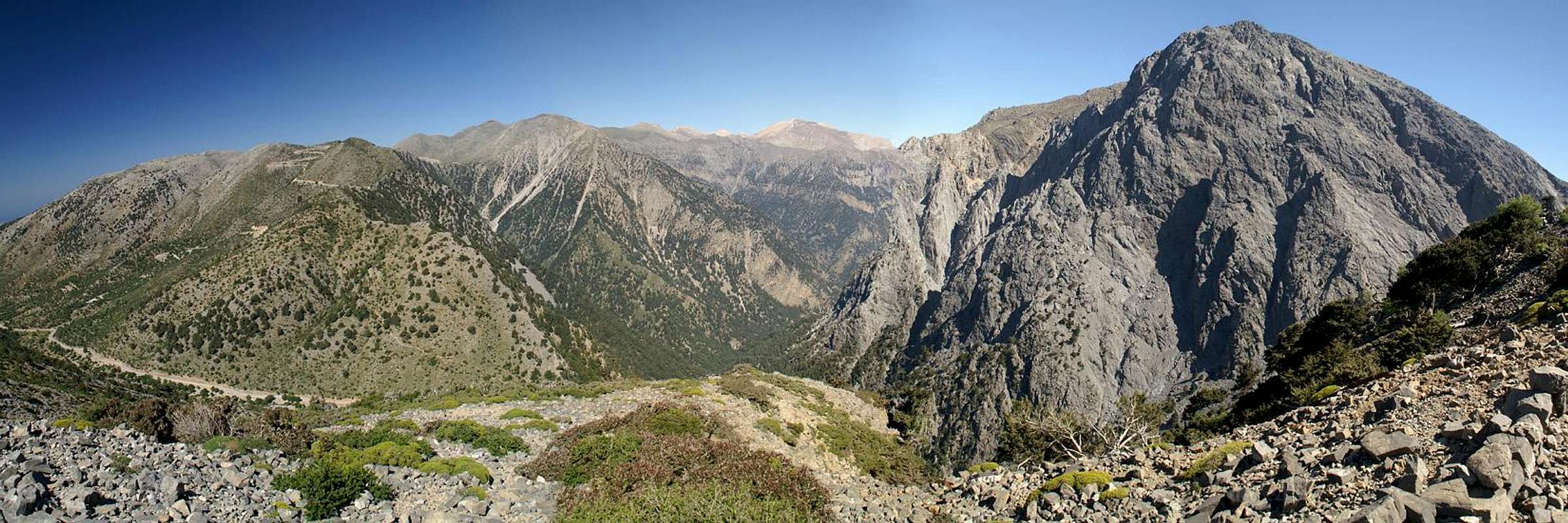
The Samaria Gorge with its surrounding mountains |
Now we drag ourselves back to Xyloscalo. The same way - endless switchbacks, hoodoos, arch, shoulder and endless switchbacks again. What a drag! But wait a minute - lighting conditions were much better than in the morning and I could take my best shots yet of the Gingilos north and east faces as well as of the Samaria Gorge. Still I was glad when I saw the parking lot and our car - only we still had 300 vertical meters to go. A large hiking group in front of us evaded the landslide zone, cutting short a switchback. We didn't - but since they hiked at snail's speed we caught up with them right after the turn.
I should have known: Dimitrios and his crew!
Luckily we reached them right at the doorstep of the Xenia Hut, into which they vanish, suddenly reaching supersonic speeds. As we passed the building they were already on the veranda, either seated at a table or hugging and complementing each other on this successful climb. Snort!
![Omalos Plain]() Omalos Plain
Omalos Plain
One last look from Xyloscalo into the gorge, pickup ice cream and a bottle of urgently needed water at the store and 90 minutes drive back home.
A good day after all.


Comments
Post a Comment