
-
 618 Hits
-
 0% Score
-
 0 Votes
Overview
In Martuljek Group, Julian Alps, there are 5 bivouacs. Bivouac III is one of those which are permanently open. It's the trailhead for the following nearby summit tours:
- On Široka peč, 2497 m, 4 h, UIAA IV/III.
- On Veliki Oltar, 2621 m, 3 h, UIAA II.
- On Velika Martuljška Ponca, 2602 m, 3 h, UIAA III.
- On Malka Martuljška Ponca, 2468 m, 3 h, UIAA I.
- On Dovški križ, 2542 m, 2 h 30 min, UIAA I.
- On Škrnatarica, 2463 m, UIAA III.
- On Kukova špica, 2427 m, 3 h, UIAA III.
- On Rutarski Vršič, 1699 m, 1 h, hike up (T3).
It also supports many climbs in the surrounding walls, passages into the neighbouring valleys, longer tours and in spring tour skiing.
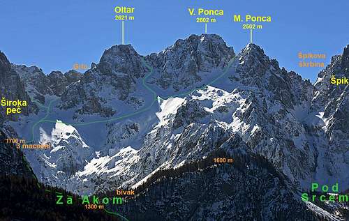
Position and Description
The bivouac stands on the lower edge of Za Akom basin, high above the Martuljek valley. It's in the forest, but from nearby, one has a nice view on the Martuljek Group from the north.
The alpine club of Jesenice built the bivouac in 1946, later it was also renewed.
The bivouac is permanently open, its purpose is to support mountain climbs in the group (not longer holidays!). It has 8 beds, a water reservoir, in the bivouac there's an iron oven. Useful phone number: +386 (0)41 733 036.
Getting There
|
The usual, shortest ascent is from the Martuljek valley, on the Swiss Hiking Scale the non-marked path is graded T3, 2h. We best start the ascent on one of the parking places south of Martuljek valley, on 760 m. The parking place is (still) free of charge. South of the parking place the two marked trails are branching, both routes are fine for ascent: 1. If we go by the left, eastern marked path, we soon reach to the Martuljek creek canyon entry. There's also an explanatory table, teaching us about the natural features. The trail through the canyon is very nice and easy, the scenery is great. Coming out on the upper end, the trail crosses the creek and starts ascending steeply towards the right. Soon we get on another bridge, offering a nice view on the Lower Martuljek waterfall. Continuing steeply up, we reach the second viewpoint (a short climb towards the left is vry worth doing), then the trail starts climbing even steeper and through the woods up to the cart road. 2. The right marked path goes first by a steep cart road uphills. Higher on it makes a few turns. The rugged cart road is more a trail, not even most suitable for mountain bikes. Gaining the hill above the gorge, we see on the left a few viewpoints and the cart road gets less steep. After some 300 m the other marked trail joins from the left. From above the canyon, we continue a bit more by a cart-road, which soon joins another, better cart road, coming from the right (there, a bit below the junction, it's possible to reach also by car, on 890 m). Then we follow it towards the south, ignoring the marked trail branching towards the right (below Špik). Before reaching the Jasenje meadow, our road goes left across the creek, while the shortcut towards Za Akom basin continues straight, avoiding the meadow and Finžgar's chapel. Above the meadow of Jasenje (close to the Finžgar's chapel), the marked trail continues up all the time by the W side of Martuljek creek. After the two variants join (the one over the meadow and the direct one), the trail starts ascending more steeply, all the time towards the SE, following a broad forested ridge. On the altitude of some 1150 m another marked trail branches off towards the left. It descends to the creek and to the Upper Martuljek waterfall viewpoint. But we continue straight up, in turns our trail reaches the rocky barrier. The passage over it goes towards the left, it is exposed and secured with pegs and steel cables. Coming over, we have only a few minutes more to the lower part of Za Akom basin. The bivouac is to the right, up in the woods, some 40 m above the basin. 2 h from Martuljek. This is also the fastest descent route. |