
|
|
Mountain/Rock |
|---|---|
|
|
41.14110°N / 74.8589°W |
|
|
Sussex |
|
|
Hiking |
|
|
1497 ft / 456 m |
|
|
Overview
People tend to scoff when "New Jersey" and "mountain wilderness" are used in the same sentence. This trio of mountains are proof positive that remarkably wild escapes exist within a short drive of the mega-sprawl of northern Jersey.All three mountains are lumps along the long mass of the Kittatinny Ridge roughly half-way between High Point on the northern border with New York, and the Delaware Water Gap on the border with Pennsylvania. Blue Mountain (1450') is tree-covered, but the other two are bald with expansive views. Bird is slightly higher (1497') than Rattlesnake (1492') and both offer great hiking through open meadows with great views of the Poconos and the Delaware River Valley to the north and west. The summit of Bird is rather indeterminate, but Rattlesnake has a nice rocky outcrop with panoramic views. A side trail leads from the summit of Bird past a lovely swamp and intersects the Buttermilk Falls Trail.
The most common hike over these two peaks, and the most rewarding for open meadows and far views, is the Appalachian Trail. From Brinks Road, the trail winds up through pleasent woods and the hump of Blue Mountain (1450'). You soon break into open territory with good views. Nearing the summit of Bird Mountain, the AT makes a sharp left into a wooded dell while a jeep road continues straight and descends steadily to the west. It is extremely easy to get side-tracked and end up near a swamp below the summit of Rattlesnake Mountain. Watch for white blazes and rock cairns.
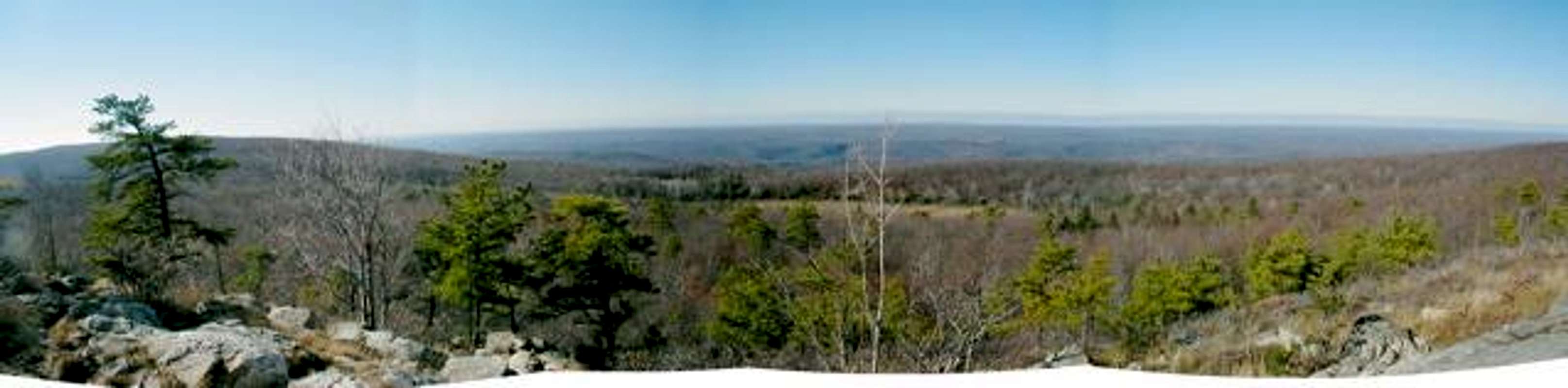
The view from Rattlesnake Mountain
Getting There
There are several access points to the Bird/Rattlesnake massif. The Appalachian Trail traverses both peaks on its way from Maine to Georgia, but several side trails provide loop options. See map for details.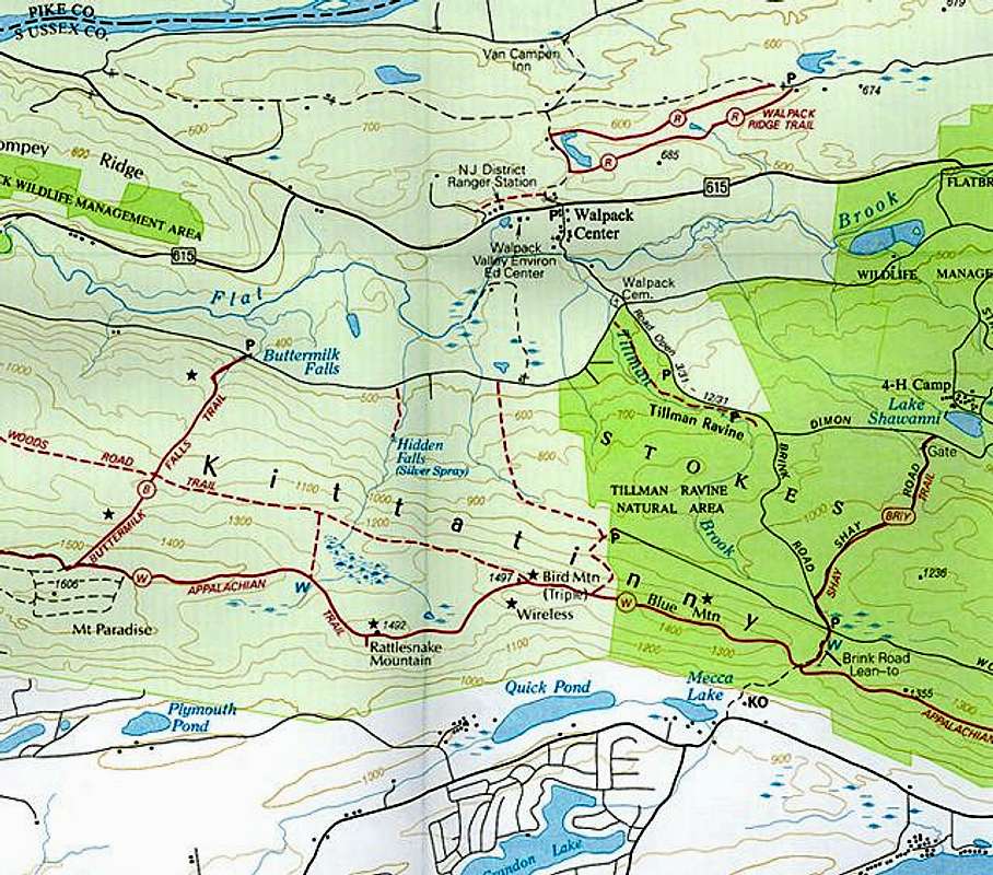
Brinks Road: The shortest route to the summit starts from Brinks Road in the Stokes State Forest on the west side of Kittatinny. Find your way to the village of Walpack Center, NJ on County 615. From Walpack, turn east on Brink Road and drive to a 4-way intersection about 3/4 of a mile near a cemetary. From here, the road is closed January through March. Continue straight approximately one mile on a rough dirt road (passable by passenger cars) past the parking area for Tillman Ravine. Keep right at the intersection with Dimon Roadand proceed another mile to the intersection with Woods Road. Park here and progress over a dirt birm and onto a wide jeep road. In a quarter mile, the jeep road intesects the AT. Bear right for Bird and Rattlesnake Mountains (2 miles each way).
Buttermilk Falls: Follow the directions above to the 4-way intersection mentioned above. Bear right and drive two miles to a parking area. The trail heads south intersecting the AT after about 1.2 miles. Bear left for Rattlesnake and Bird. Added on May 10, 2005:
The Road from Tillmans Ravine to Buttermilk Falls is closed because of the hurricane last Sept.(04) and heavy rains this April (05).
Culvers Gap: This is the farthest access point, but easiest to find. Follow US206 west from Newton, NJ to the small, lakeside town of Culvers Inlet. The AT crosses the highway in the narrowest part of the gap in the ridge and climbs steeply up a view-ridden ridge. From the gap, it is 3.6 miles to Brink Road and an additional 2 miles to the summit of Rattlesnake.
Red Tape
Complete regulations for the New Jersey AT can be found at this link.When To Climb
Rattlesnake and Bird Mountains are accessible any time of year. The Brinks Road TH may be inaccessible January through March.Camping
Camping is available at the Brink Road Shelter on the AT 2 miles north of Rattlesnake Mountain. The Gren Anderson Shelter 8 miles to the north is another good option.Mountain Conditions
More Infomation
Stokes State Forest1 Coursen Road
Branchville, NJ 07826
(973) 948-3820
I've adopted CharlesD's original page and have made some minor improvements and changes. Anyone with photos is urged to submit them. Thanks! -- RobA
External Links
- Stokes State Forest
Offical Site for Stokes State Forest