
-
 8929 Hits
-
 77.48% Score
-
 8 Votes
|
|
Route |
|---|---|
|
|
29.03445°N / 13.73171°W |
|
|
Hiking |
|
|
Spring, Summer, Fall, Winter |
|
|
Half a day |
|
|
Hike |
|
|
Overview
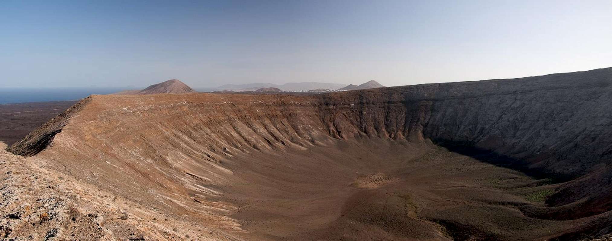
 Caldera Blanca from teh south-east. Caldera Blanca from teh south-east. The route follows the whole ridgeline |
The round trip around the crater of Caldera Blanca is a 3h affair, when undertaken from the village of Mancha Blanca. Several parts follow dirt roads which serve the farmers of the area to till their fields. However, the largest part of the tour runs across lava fields on paths which are "dug" out of the sea of rocks. Most of the time the lava piles up quite high so that you don't stand many chances of views before reaching the caldera rim.
In character the route is a hike. But in several sections the hike turns into a scramble, namely both before and after reaching or quitting the rim. In general, a crater should always be climbed along the rim, due to the more solid ground on the top. Caldera Blanca, however, has a circular crater so that the rim needs to be reached first. As is usual with volcanoes the paths run across brittle cinder slopes.
Getting There
See the main page for the itinerary to Mancha Blanca. The trailhead is where the regional road LZ67 turns from west to south-west.Route Description
  |
- Start altitude: 250m
- Summit altitude: 458m
- Prevailing exposure: All directions
- Type: Hike and Scramble
- Protection: None
From the trailhead near Mancha Blanca, where LZ67 turns south-west, take a dirt road leading west straight ahead. The road serves the field patches around Mancha Blanca but soon vanishes near a sign, giving explanations about the Parque Natural de los Volcanes. Here a narrow path heads into the lava fields, climbing up and down a lot while generally keeping the same elevation. Aside from the track the lava is barely penetrable. The path heads for the north slopes of Montaña La Caldereta, where quite suddenly an opening into the crater is revealed. Climbing Montaña La Caldereta is possible, also descending into the crater. However, the slopes of the caldera are very steep and appear to be rather brittle.
 Montaña La Caldereta
Instead, turn right (west) from the opening and follow a path gradually climbing the west slopes of the crater. It heads out onto a lava-covered high plain where it crosses another dirt road serving a farm cabin between the two craters. Now the track heads up the Caldera Blanca north-east slopes and finally reaches the crater rim in its north-east. Follow the broad rim to the summit which is marked by a pillar. Enjoy the views.
 Risco Quebrado
From the summit leave the rim to the east and head for the ridge which connects Risco Quebrado with Caldera Blanca. Again, a side-step is possible (15 min). Instead head onwards and return to the rim in its lowest spot west of the crater. After a last glimpse into the caldera turn west and head down on the outward side. The path now is a goat herder's track, plainly visible, taking you quickly to the base of Caldera Blanca.
 Risco Quebrado during the descent
You'll reach an intersection with two dirt roads. Take the road, which leads eastward, passing the caldera to its north. After a while you'll hike through patches of farm land, which belong to the farm cabin, described before. A lava scramble leads you back to the opening of Montaña La Caldereta. Return to Mancha Blanca the way you came.
This three hour hike can be combined with another loop, which eventually leads you to Caldera Colorada. Both routes climb about 1200m in elevation and 26km in distance. They take 9h to complete both, though the single Loops can be performed in little more than 3h each.