

-
 12374 Hits
-
 74.92% Score
-
 5 Votes
|
|
Route |
|---|---|
|
|
39.42244°N / 105.07902°W |
|
|
Hiking |
|
|
Spring, Summer, Fall, Winter |
|
|
Half a day |
|
|
Class 1 |
|
|
I |
|
|
Getting There
Roxborough Park
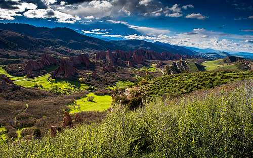
Roxborough Park, at once charming and idyllic, offers a quiet paradise of exposed geologic time and wildlife with a short but worthwhile hike to a surprising perch above the evergreens of the nearby canyons and housing developments. This a very unique State Park and is worth a visit at least once in your lifetime.
If not for its place within Roxborough, Carpenter Peak might be overlooked. This shouldn't be so, as it surveys the expanses of this magical place from high above. One might attain the summit block via Waterton Canyon or the Colorado Trail from the west; however, the Carpenter Peak Trail offers the day hiker a much more modest approach.
From the entrance station at Roxborough State Park (entry fee required), follow the road for 2 miles to the parking lot at the visitor center. The road is gravel for about a mile and then becomes a nice paved road with speed bumps. The speed limit is 20 mph, so watch for the speed bumps! There is only this one road and it ends at the visitor center. From the parking lot, you can reach the visitor center in about 200 feet via either the road or the more civilized sidewalk.
The Carpenter Peak trailhead is located just west of the visitor's center in Roxborough State Park. It is well marked and visible from the visitor center.
Route Description
Trail Junction Just Below the Summit
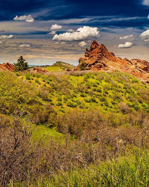
Rock Formation in Roxborough State Park
The trail starts out through some dense scrub brush just below some beautiful red rock formations. As the trail tapers south, it opens up to a large meadow and then turns west. The huge formations to the south offer fantastic photo opportunties, and often this is where you might see white tail deer grazing. Cross a gravel road and continue on the very well-defined trail as it starts to gain elevation. Pass a few benches, which seem to be dispersed along the trail at half-mile intervals, and the intersection with the Elk Creek trail until you see Carpenter Peak at the northern (right) end of the long ridge in front of you. Don't spend too much time on the benches though...these are what I call mountain lion buffet tables.
Persevere along the easy trail as it switchbacks toward Carpenter Peak at all signed trail junctions. Carpenter Peak is the highest rocky point at the north end of the ridge that runs north to south. Continue on the trail as it winds through the forest until you arrive at the last trail junction, which is signed. Take a right for 0.1 miles to the rocky summit. The summit boulders offer lots of space for a picnic but the summit block fits only about 4 people. Share it with your fellow hikers!
Elk Valley Trail
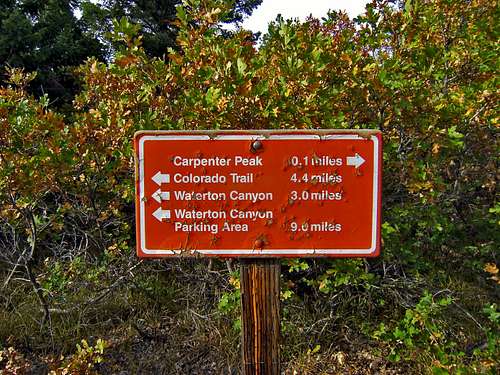
The Elk Creek trail intersects with the Carpenter Peak Trail about 1.25 miles from the gravel road. This 0.8 mile trail takes you over a pass and to a double-track road. This road heads southeast-northwest. Head southeast and the road widens and then circles back toward the visitor center. It also connects to the Sharptail and Swallowtail trails (both are in Douglas County Open Spaces), popular with mountain bikers. Head northwest to an intersection. Continue on the unsigned Powerline Trail (straight) where it intersects with the Indian Creek Trail (left) and continue along until you reach the spur trail that heads right about 0.5 miles to Carpenter Peak (and the red sign); If you keep going north from the aforementioned spur trail, the trail takes you to Waterton Canyon and/or the Colorado Trail. Since Waterton Canyon seems to be closed all the time, this is one way you can get to the start of the Colorado Trail. I have heard from a few people who can't seem to locate the Elk Valley Trail when going in reverse from Carpenter Peak. I can assure you, there is a very visible sign that says "Elk Valley Trail" right out in the open where it is supposed to be. If you have not found it, you didn't hike far enough.
Powerline Trail
The Powerline Trail is the key to completing a loop hike of Carpenter Peak. This trail intersects at the Indian Creek Trail and then further along with the spur trail to Carpenter Peak, or keep going and it takes you to Waterton Canyon and/or the Colorado Trail. From Carpenter Peak's summit, head toward the Colorado Trail/Waterton Canyon trail, which is clearly marked with a red sign. After about 1/2 mile, this spur trail ends at a T-intersection. If you head right (northerly), this takes you into Waterton Canyon. If you head left (south), this is the Powerline trail. This is a nice trail that will take you into the south part of Roxborough along the border of Pike National Forest. The trail follows a stream for a while, and offers a chance to filter some water. This is wilderness so be prepared. The Roxborough State Park map does not identify the Powerline Trail, but it is clearly marked on the Deckers/Rampart Range topo map (135).
In winter, snowshoes or microspikes would be useful as some portions of the trail become icy and snow packed from lack of sun exposure and moderate traffic.
Essential Gear
Basic hiking essentials for a 3-4 hour hike through the woods.In winter, snowshoes or microspikes would be useful as some portions of the trail become icy and snow packed from lack of sun exposure and moderate traffic.