
|
|
Route |
|---|---|
|
|
43.88120°N / 71.8433°W |
|
|
Hike |
|
|
Half a day |
|
|
Class 1 |
|
|
Approach
VIA THREE PONDS TRAILHEAD (1310'): From I-93, Take Exit 26 west toward Rumney. At 3 miles you will come to a traffic circle. Stay to your right towards Rumney and Warren. Continue three more miles until the intersection of NH 49 (Flashing lights). Take NH 49 through the beautiful quaint town of Rumney and up toward Stinson Lake. Continue through Stinson Lake until you reach gravel road (about 6 miles). Stay on the gravel road one mile and the Three Ponds Trailhead will be on your left.Route Description
Three Ponds Trail (0.5 miles one way)
Carr Mountain Trail (2.5 miles one way)
Total Roundtrip Distance 6.0 miles
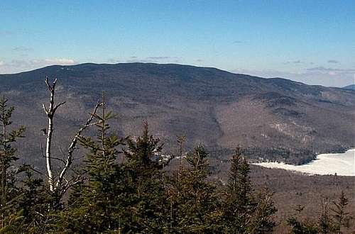
This six mile roundtrip hike is the easiest route up to the top of Carr Mountain. Though there are no good views on the way to the top of Carr Mountain, this trail is special in that near the mid point of the trail, the trail goes underneath the roots and trunk of a dead tree that looks something like an octopus. Once on top great view can be seen especially of the north toward Mt. Mooselauke and Franconia Ridge.
The hike begins from the Stinson Lake Rd. parking area on the Three Ponds trail. The Three Ponds Trail begins with a moderate ascent for about the first 0.3 miles. The trail then moderates for the last 0.2 miles and becomes flat to slight lowering in elevation towards the Carr Mountain Trail.
The Carr Mountain Trail (left) quickly descents at easy to moderate grades towards Sucker Brook. The trail hits Sucker Brook at 0.2 miles from the beginning of the Carr Mountain Trail. Even in drought conditions this river crossing can be difficult. After Sucker Brook the trail appears to meet up with an old logging road and descends up Carr Mountain at a moderate pace. At 1.4 miles the trail makes a sharp left and at 1.5 miles the landmark old tree and route is passed underneath. The trail then makes a sharp left at 1.7 miles where it then continues up the ridge near a small brook. It crosses the mossy small brook and the trail becomes rockier and moderate again as the trail winds its way to the top. The trail then level out near the top and a side path leads you to the summit (The AMC White Mountain Guide has this at 2.9 miles but the sign at the top has it as 2.5 miles (3.0 to Stinson Lake Rd. Parking area). Once at the summit with the remenents of the old fire tower (where descent views can be seen), climb one of the summit rock towards the north for the best views.
Essential Gear
In summer nothing more is needed then hiking boots and essential hiking gear. Just remember to avoid in April due to mud season and high water on Sucker Brook and bring bug repellent year round but especially in June (black fly season). They will be itching to bite you.In winter snowshoes are needed for snow can be up to five feet deep by mid winter. Crampons are not needed but could prove helpful in very icy conditions. The road past Stinson Lake is not maintained in winter so don't try to hike Carr Mountain after a major snowstorm unless you have four wheel drive.