
-
 3212 Hits
-
 78.27% Score
-
 9 Votes
|
|
Route |
|---|---|
|
|
46.12965°N / 12.49639°E |
|
|
Hiking, Scrambling |
|
|
Summer, Fall |
|
|
Half a day |
|
|
Up to UIAA II |
|
|
Rating The Tour (By Hiking Standards)
0. General. From 1300 m to 2251 m, exposition S and W. All the time marked. Into the upper Val Sughet an easy path, then a narrow path over steep grassy slopes, a few unprotected easy climbing sections and easy ferrata sections to the top. By the Swiss (SAC) Hiking Scale the rating would be T4. Gear (in dry seasons): Only good shoes and poles.
1. Effort. 950 m, 2 h 45 min.
2. Power. 3 - medium.
3. Psyche. 3 - medium.
4. Orientation. 1 - no difficulties (all the time good marked paths).
The grading system for hiking and scrambling routes is here.
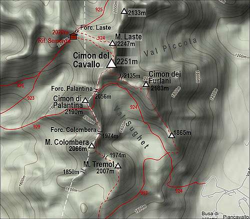
Overview & Getting There
This is the usual ascent route on Cimon del Cavallo, also the quickes possible ascent if you reach trailheads by a car. In the upper part there are two options which can be combined in a short round tour. See the main page of Cimon del Cavallo how to get on Piancavallo plateau!
Route Description
On Piancavallo we start the tour behind (on the W side) the football stadium, on some 1300 m. There is also a table with the detailed map. The path goes up the meadow, hits the cart road and continues left to a small quiarry which is nowadays arranged for sport climbing. Behind the quarry the path goes uphills. We go through a nice beech forrest, following red marks in a shape of arrows. The path is weak, only higher it gets more easilly visible. Over a rocky step it ascends up and towards right, the continuing ascent in the northern direction already brings us into the lower part of Val Sughet. Over an undulated plateau we continue to the crossroads on some 1700 m. A nice view on Cimon del Cavallo opens. Good 1 h till here.
 On the 1700 m crossroads in lower Val Sughet
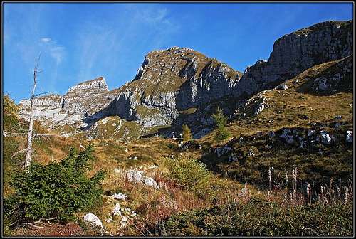
On the crossroads we continue straight. The path goes first over the plateau, then it keeps north and goes just below the walls of Cima dei Furlani SE ridge walls. The path is not steep, it overcomes several scree sections. The overall direction is NW. When reaching the S face of Cimon del Cavallo, some 2000 m, we notice signs deterring towards the right. This is the point from which we have two options, approximately equally hard:
1. Southern ravine ferrata. If we deter right, the marks direct us toward a dark ravine, but the path soon exits towards the right on steep grassy slopes. In many turns it goes steeply up and soon reaches Forcella dei Furlani, 2135 m. There the path turns left on a distinct ledge, which is partly wide and comfortable, partly also narrow, but all the time protected by a cable. Going far to the left into the S face of Cimon del Cavallo we might think the path will cross it completely, but reaching a narrow rocky ravine which opens above us, the path turns right up through the ravine. It becomes a steep, quick and fun climb. The climb through the ravine is all the time protected by a steel cable, so this part is an easy ferrata. It exits just a few meters below the summit. By a grassy ridge we soon reach it.
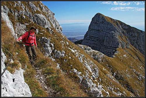 In the southern face - the ledge
On the SW ridge

The steep upper part
2. By the SW ridge. If we continue by Val Sughet, the pathe slowly starts to turn into the W and then even into the SW direction. It comfortably ascends too, so we easilly reach Forcella Palantina, 2055 m. There we turn sharply right and start ascending by the SW ridge on Cimon del Cavallo. The route is not just easy, but also not difficult. A few exposed and not protected sections require some care and also easy climbing, but not harder than UIAA degree I. The path is winding by the ridge, often also going into its shady western slopes. Only a few sections are protected by steel devices. Higher, the path reaches the compact summit rocky structure. There it goes again into the W side, where it climbs up through a steep ravine. That part is well protected by a steel cable. After exiting the rocky section, we have only the grassy summit part of the SW ridge to overcome. We pass the exit of the southern ferrata and soon reach the top. For the descent we can go by any of the above described options into val Sughet.
Show a bigger map
External Links
Route description in Italian: http://www.vienormali.it/montagna/cima_scheda.asp?cod=393