
-
 4285 Hits
-
 73.06% Score
-
 3 Votes
|
|
Route |
|---|---|
|
|
46.59591°N / 13.00447°E |
|
|
Hiking |
|
|
Summer, Fall |
|
|
Most of a day |
|
|
Medium hard walk-up |
|
|
Rating The Route (By Hiking Standards)
0. General. From 1215 m to 2217 m, slopes orientation north, east and south. Non-marked paths which can be easilly lost, above a good marked path, with some steep (rocky) sections just below the summit. Gear: Only good shoes and poles.
1. Effort: 1050 meters of altitude, 5 hours (or 4 hours if you orient perfectly).
2. Power: 1 - no difficulties (only walk-up.
3. Psyche: 2 - easy, a few steep and a bit exposed sections below the top.
4. Orientation: 3 - middle (non-marked paths are hard to follow).
Overview

Below the North face of Creta di Timau
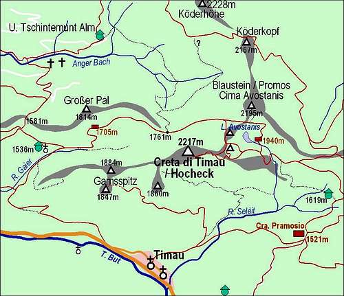
Creta di Timau is obviously seldom ascended directly from the Austrian (northern) side. Perhaps hikers come all the way along the main crest from Kleiner Pal, where in summer the cable-car brings you. That tour would require some ups and downs. But the route from the end of the valley is hard to follow, so a short description here. I did it in descent. As that same day I had ascended also Polinik, on the other side of the valley, I was already a bit tired on the summit of Creta di Timau (did more than 1900 meters of altitude that day). As night was approaching quickly, I had to hurry a bit, but still needed 3 hours down to Ploecken Haus.
Route Description
Creta di Timau and its paths
From the parking place near Ploecken Haus (see the main page how to get there) you take a macadam road (closed for public traffic) into Anger Bach valley. Till Untere Tschintamunt Alm, 1490 m, you need almost 1 hour. There continue eastwards (find a non-marked shepherds path across the side creek), you go all the time above Anger Bach (main creek), on its northern side. In 30 minutes you should reach the clearing at the end of the valley.
Here many creeks come down from Blaustein (Promos) and join. A good path turns right towards the South and then through dense bushes and woods towards the South-West. The path is unpleasant, it crosses some creek beds and bush overgrown slopes and after some 20 minutes it's also hard to decide when to turn up, in the direction of Passo di Palgrande / Tischlwanger Toerl, 1760 m. The slope is crossed by paths of many animals, but their tracks go mainly in a left-right direction. As there is no path also walk-up is enduring, rocky slopes also require some care not to twist your leg. Finally, in another 30 minutes you should exit above on the pass, hitting the marked path, coming up from the right, from Casera Palgrande di Sopra.
Included searching, you'll need almost 3 hours till here. From Passo di Palgrande / Tischlwanger Toerl on, the route is much nicer and easier. The marked path brings you close to the northern face of Creta di Timau, through a beautiful boulders landscape you quickly ascend the upper part, where the path winds in many turns towards the main ridge. Below the ridge it branches, and you take the right branch - towards Creta. In a few minutes you ascend on a nice notch. There's a ruin of ex military building (from the World War I) and also a very nice view down on Lago Avostanis surprises you.

Lago Avostanis from the ridge

World War I fortifications
From the notch you continue the ascent by the narrow ridge towards the summit of Creta. The path first ascends a few steep sections, you can inspect some caverns from the WW1, but soon the ridge becomes too sharp and the path avoids it on the southern slopes. Over grassy and rocky slopes you soon reach another notch in the ridge, also fortified with buildings from the WW1. Now you expect to attack finally the summit ridge, but the path again takes you over the slopes on the southern side, where it hits a broad mulatiera (supply path from the WW1), which comes from the hut below on the Italian side. In few turns you gain some altitude, you cross more slopes and finaly by a big cavern (a whole house could go into it) the broad path ends. In the nearby ravine marks lead you over some 15 meters of rocks (easy climbing, somewhere between a steep walk-up and a UIAA Ist degree climb) on the summit ridge and in a few next minutes to the top.