
-
 6562 Hits
-
 72.08% Score
-
 2 Votes
|
|
Route |
|---|---|
|
|
43.53087°N / 5.58071°E |
|
|
Hiking |
|
|
Spring, Summer, Fall, Winter |
|
|
Half a day |
|
|
Medium hard walk-up / a few sections of UIAA I |
|
|
Rating the Route (By Hiking Standards)
Croix de Provence and its South-west ascent
The grading system for hiking and scrambling routes is here.
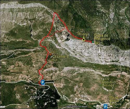
0. General: From 320 m to 945 m, exposition S and W. At first a comfortable cart road and good, marked paths through a very nice mountain scenery. Above some steep passages over rocks, but all the time well marked. The harder variant requires on a few spots some easy climbing of UIAA I degree.
1. Effort: cca 630 m, 1 h 45 min.
2. Power: 3 - Moderate (mostly 1 - no difficulties, on some places of the harder variant a few pull-ups - UIAA I degree).
3. Psyche: 3 - Moderate.
4. Orientation: 2 - Easy (the easier variant is 1 - no difficulties, all the time well marked, the harder variant requires just some basic attention on passages).
Getting There
See the main page how to get to the parking place near Le Bouquet. You can reach Cabane de Cézanne also from the east, from Maison de Sainte-Victoire, which means a bit longer route, but some less altitude difference.
Route Description

Croix de Provence Picturesque rocks along the way
From the shady parking place we first cross the creek and then start ascending, either by the cart-road or by the nearby marked path. Going northwards we soon reach some colourful places with unusual rocks, and also spot the characteristic boulder, behind which the plateau with Cézanne's hut is hiding. We reach the hut in some 20 minutes. There is a crossroads. Another path comes from the right, from below the southern walls of Croix de Provence, the road continues to the left, but we continue straight up, towards the N or a bit NW - follow the inscription: Pas de l'Escalette (Sentier Imoucha!).
The marked path now ascends more steeply over a mountain step. On top of it, we have a great view into the vertical walls of Croix de Provence. There the path branches. If we want to do a round tour, it is recommendable to choose the harder variant for the ascent and return later by the easier variant.
a - Harder variant. So, we go to the right on the direct route and marks soon bring us to the rocky walls. The route enters the wall over a steep section where the first easy climbing is needed. A few pulls-up, a few careful steps, nothing special, because the rock is very good. Above, the route finds the easiest passages among the rocks, so we quickly gain altitude. Some care is all the time needed, a medium hard walk-up continues for some 45 minutes. At the upper part the route avoids the steepest part of the W face and goes more to the left, towards the main ridge. Over the last, a bit steeper section, we then exit on the main ridge and the northern panorama opens. The normal path joins us from the left.
b - Easier variant, over Pas de l'Escalette. The easier variant continues across the western slopes of Croix de Provence in the northern direction. We clearly see in the rocky main ridge of the massif the place, where the rocks are less steep and the path overcomes them. There some care is needed - on one or two places the path is less well beaten, but altogether the whole ascent stays easy. So we reach the main ridge on Pas de l'Escalette, turn right and continue by it towards the top.

Croix de Provence Hiking below the main ridge

The final section of the ascent is a broad, well marked path along the main ridge, over some steeper places it does a few turns too. Soon the priory is in front of us and we enter on a nice, shady backyard. On the right, just a few steps away is the panoramic Breche des Moines (Monks' Notch).
To ascend the highest point with the cross, we go through the refugium and continue by the path, which ascends in few turns steeply to the summit rocks with the cross. Enjoy the great panorama! We descend best by the easier variant. The whole tour can be done in less than 3 h 30 min, but you will spend much time enjoying nice scenery.
Essential Gear
Hiking shoes and poles.