
-
 19403 Hits
-
 80.05% Score
-
 12 Votes
|
|
Route |
|---|---|
|
|
35.91780°N / 81.90353°W |
|
|
Hiking |
|
|
Overview

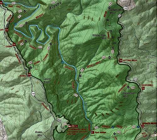
Jonas Ridge
The Devil’s Hole Trail resides in the northeast quadrant of the Linville Gorge Wilderness. Starting at the junction with the Jonas Ridge Trail, Devil’s Hole descends 1000 feet in 1.5 miles and dead-ends at the Linville River.
In and of itself, there is nothing spectacular about the Devil’s Hole Trail. It is a 1.5-mile walk through the woods. However, depending on objectives, for backpackers and adventurous dayhikers Devil’s Hole is a strategically important trail. If you are able to successfully ford the Linville River the trail opens up options for reaching destinations on either the east or west side of Linville Gorge, as well as providing another option for completing a loop hike.
Within Linville Gorge there are very few options for crossing the Linville River at a designated trail. The most common river crossing points are at the bridge at Spence Ridge or by fording at the far southern end of the gorge on the Mountains to Sea Trail. Devil’s Hole offers a possible river crossing farther north. Besides creating additional options for loop hikes, if you are coming from the west side, Devil’s Hole allows for access to Jonas Ridge Trail which leads to Hawksbill Mountain to the south and to Sitting Bear Mountain and Gingercake Mountain to the north.
Getting There
East Side Approach
Devil’s Hole Trail starts at the junction of the Jonas Ridge Trail. It is a 0.1 mile hike from the Sitting Bear Trailhead to the junction. Follow the directions for Getting There on the Sitting Bear Mountain page to reach the trailhead.
West Side Approach
Reaching the trail from the west side requires hiking down to the Linville Gorge Trail (LGT) from one of the many west rim trails and crossing the river. The shortest approach from the north is 1.4 miles from the Babel Tower Trail/LGT junction. The shortest approach from the south is 2.1 miles from the Conley Cove Trail/LGT junction. Follow the directions for Getting There on the Linville Gorge page to reach west side trailheads on the Kistler Memorial Highway.
The biggest challenge on this approach is finding the location for the river crossing as the forest service has not placed a trail sign here. Local trail advocates have nailed a sign onto a tree! The GPS coordinates listed on this route page are for the approximate location of the river crossing. From the LGT it is an easy bushwhack of several hundred feet down to the river.

|

|

|
Route Description
Again, the Devil’s Hole Trail is 1.5 miles long with 1000 feet of elevation change. It is a walk in the woods. The real benefit of the trail is that it provides access to opposite sides of the gorge via a crossing of the Linville River.
River Crossing
From the reports I have read there is quite a bit of conflicting data on the ease of the river crossing. In most of these reports the hikers chose to turn around rather than try crossing. Keep this in mind if you choose this route, particularly if you are coming from the east, as it is a steep 1.5 mile hike back up the Devil’s Hole Trail!
There are cairns on both sides of the river to identify a place to cross. I crossed at this point, going from west to east. It required getting in the river, chest deep. We went upstream and downstream at least 25 feet from the cairns and did not locate any place that would allow us to rock hop across. From my experience, the crossing requires getting in the river, which is why I recommend this route only for the summer as the water is warm enough to get into at that time. If the river is low enough, I assume it can be crossed here without getting in the water, but I do not know that for a fact. Regardless, great care needs to be taken, as the river runs fast and is deep in spots, thus making the crossing potentially dangerous. Use good judgment!

|

|
Coming from the west, once across the river there is about a 10 – 20 foot scramble up to a clearing. There is a large backcountry campsite here, but there is no sign indicating where the trail starts, and there are several spur trails that head out from here, so it is confusing. Turn left (north) and the trail starts near a small stream less than 100 feet from the campsite.

|

|
Backcountry Camping
There is a large campsite where the trail dead-ends at the river.
Between May 1 and October 31st, permits are required for backcountry camping on holidays and weekends. Reservations are taken on a first-come-first-serve basis, beginning the first working day of each previous month. Length of stay is limited to two nights, and the group size cannot exceed 10. Contact the Grandfather District Ranger Station at 828-652-2144 to make reservations. There is no fee to obtain a permit