By Tuesday evening we had experienced 4 days when we had either rain or low cloud, usually clearing in the evening but no really good weather days. For Wednesday, that was going to change.
“There are two different ways we can do this,” I began, pointing at the map.
Seekarspitze - Seebergspitze traverse. South ridge of the Seebergspitze
“One…we can start from here in Pertisau as early as we’re ready. Go up the south ridge of the Seebergspitze, then traverse the ridge northwards to the Seekarspitze and descend northwards to Achenkirch village, then get the bus back here.”
“Ok” said Marie, “What’s the second option?”
“Same thing, but the other way around.” I replied
“So which is best?”
“Well, if we start from Pertisau, we can start early when it’s cooler but we will have to wait for a bus back at the end. If we took a long time, that might be a long wait.
Whereas, if we get the bus first, we’ll inevitably start later unless we skip breakfast.”
“I’m not missing breakfast on a big mountain day,” Marie interjected.
“Ok, so we’ll start later from Achenkirch, traverse the ridge southwards and descend to Pertisau. It will be later and warmer when we start but there’s no need to get a bus back.” After a pause I continued. “Also, the route descriptions say there is cabling to protect the scramble up to the Seeberspitze from the ridge between the two mountains. That gives me the impression that part is the steepest bit of the ridge. It will be easier to go up than down.”
That settled it, we looked up the bus timetable for Achenkirch.
Seekarspitze (2053m)
Next morning, we were at the bus stop at 8.45, ready for the bus. There were 3 others there waiting, one of whom was definitely English – we later discovered they were heading for the same route.
We changed buses at Maurach and were swamped by about 40 schoolchildren! They pushed in at the front of the queue at the Mittelschule bus stop, took all the seats and created absolute bedlam!
It seemed like they were coming home from school (at 9am in the morning?) as intermittently, one of them stopped the bus to get off. I could only imagine they had gone to school, only for it to be cancelled… and they were heading home and ecstatic!
Eventually, Marie and I got a seat but it was noisy, claustrophobic, hot and stuffy. Usually, I don’t get travel sick but I began to feel a bit queasy!
By the time we got to the caravan park bus stop at the north end of the Achensee, it was a relief to get off and take some deep breaths of air. We walked to the start of the route at the head of the lake and sorted our gear out on a bench by a wide, upward heading, forestry track. It was 10.00 am. The signpost said “Seekarspitze – 3h”.
As we did this, most of the people who had left the bus with us, arrived and headed off, not up the track but along a small path by the river.
“Everyone is going that way,” Marie pointed out.
I looked at the map. “Perhaps they’re doing different routes.” I said but wondered if they knew something we didn’t.
“I think we should follow them,” Marie said.
I don’t usually like to just “follow the crowd” if I’m not sure where they’re going but I agreed and we set off along the shady path by the river (Oberaurbach).
As we walked, I contemplated the morning so far.
Seekarspitze - Seebergspitze traverse. Ascending the Seebergwald
We had been ready to leave the hotel at 8.30. We got the bus with the hordes of manic children, then we set off from Achenkirch at 10.00 on a path I’m not sure of. Maybe we should have gone straight up from Pertisau to the Seebergspitze? Leaving at 8.30, we would be half way up the route by now instead of just starting out.
As we followed the river, I became more anxious as we were heading in the wrong direction but soon the path veered away from the river and steeply upwards through the trees. It was then I realised where we were.
Although the recommended route follows the forestry track, there is a direct route that heads up from the Oberaubach, ascending what is marked as the “Seebergwald” on the map. As well as being a shorter route it avoids the Koglalm and the mid - morning sunlight which in early September was still warm.
The path wound its way upwards through the dark forest. Although we were in the shade, it was quite humid and I was sweating profusely but glad we weren’t out in the sun! We were drinking our water supply quickly and would run out if we continued like this.
As we got higher, we overtook 2 of the “Englishmen” and occasionally got good views norththwards through the trees to the hills west of Achenkirch.
We came out of the trees into a wide gully and spotted the summit cross of the Seekarspitze, way above us. Soon, we crossed the main, wide forestry track we had seen earlier and met the third Englishman.
“Have you seen anything of my companions?” he asked us.
“Yes, I don’t think they are that far behind,” I replied.
“They’ve decided against bringing their macs to cut down on the weight, I don’t trust the forecasters that much”, he checked his phone for any weather updates.
Seekarspitze - Seebergspitze traverse. Ascending the Seekarspitze
“Have you done this route before?” Marie asked him.
“Oh yes,” he replied “twice before. It’s a great route. You’re nearly up to the Seekaralm. It might be open this time of the year.” He continued.
We thanked him and crossed the road, continuing upwards on a path. Soon we were back on the track and heading up to the Seekaralm, it was open and we stopped to unzip the legs off of our trousers and get a cold lemonade from the alm keeper.
This route had taken 1 hour from the start – probably quicker than the main track - and mostly in the shade. So “following the crowd” had worked!
We resumed our ascent at 11.30, at first on a wide track that soon narrowed to a steeper, rougher path through the scrubby vegetation. I thought for a while I had taken the wrong route as we seemed to have lost the red and white “flashes” that show the way but they soon returned as we got higher.
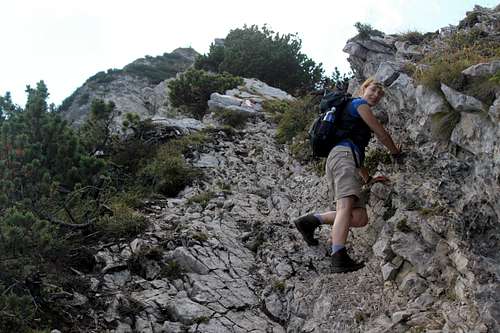
The vegetation ended and we were found ourselves scrambling up short buttresses of rock with loose limestone scree all around. I was pleased we were not planning to descend this as it was ok to go up but would be unpleasant to descend.
Suddenly, I crested the ridge and saw a great view of the Achensee below. The ferry looked small in the expanse or turquoise water and all the other boats I could see were tiny. Above the Achensee, the Rofan massif looked a bit hazy as we looked into the sun but behind us and across the valley, the Unnutz mountains were clear.
Seekarspitze (2053m) - nearing the summit
The ridge caught a refreshing breeze as we scrambled towards the summit over the blocky Limestone rock, arriving at 12.55, we found a place to eat our lunch near the summit cross. Finally, I got rid of that queasy feeling!
For such a good weather day in September there were surprisingly few people on the summit, the “3 Englishmen” (we only ever heard one of them speak so were not sure if they were all English), 2 German couples and 2 other family groups, one with a dog.
We all sat admiring the view.
Traverse
Seekarspitze - Seebergspitze traverse
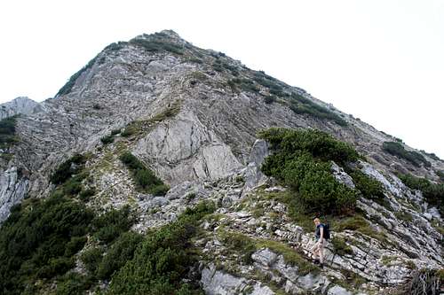
The family groups soon left to return northwards to Achenkirch, leaving the rest of us to start the traverse southwards to the Seebergspitze.
A few large clouds had appeared high above us and our route was in and out of the sun for the rest of the day, but never cold.
The Englishmen set off and after a while we followed – we prefer to try to be as alone as possible on the mountain so we gave them a good start. One of the German couples were close behind us but they soon fell behind as we continued and we were alone until we reached our summit destination.
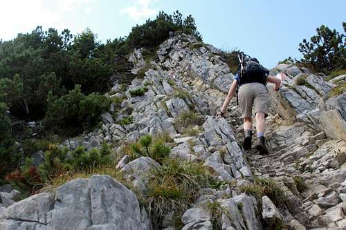
The route descends gently from the Seekarspitze on a rough path near the crest of the ridge. Every now and then, there is a steeper scramble down the broken limestone. We found this awkward at first as we were still using both of our trekking poles. However, once we put one away, the going became easier.
All along the ridge there are great views southwards over the Achensee towards the town of Maurach at the southern end and the Ebner Joch that overlooks the town. Westwards and below us, the Pasillalm could be seen in the afternoon sun and further afield, the ranks of Karwendel peaks stretched into the distance. At the moment and to Marie and I, most of these summits are an unknown world, waiting to be discovered.
The route from the Seekarspitze continued to descend and as it did, the upcoming ascent of the Seebergspitze looked more and more impressive. (Strangely enough, from the other side of the Achensee, this descent and (re) ascent does not look significant at all.)
After about 40 mins, we reached the low point of the ridge and an escape route westwards and down to the Pasillalm. We stopped for a drink. The ridge reared up to the summit of the Seebergspitze and ahead we could see the 3 Englishmen scrambling up the steeper rock, time for us to put our trekking poles away.
The scrambling was enjoyable and not too steep and the route easy to follow. I always think that when I’m scrambling like this, the route passes quickly. It wasn’t long before we were looking down on the ridge we had recently traversed and by looking upwards, the Seebergspitze summit cross seemed nearby.
Many route descriptions say that there is cabling on this route towards the top but we saw no trace of any. Not that we needed it. The scrambling gave way to a rough path again and a grassy knoll just before the summit cross. We arrived at 2.35 pm, nodded to the familiar faces and sat enjoying some water and a bite to eat in the afternoon sun.
Seekarspitze - Seebergspitze traverse. Scrambling up the Seebergspitze
Seekarspitze - Seebergspitze traverse. Scrambling up the Seebergspitze
Seekarspitze - Seebergspitze traverse. Scrambling towards the summit of the Seebergspitze
Seebergsitze (2085m)
Seekarspitze - Seebergspitze traverse. Nearing the top of the Seebergspitze.
After a while, the other summiteers were leaving and we got our stuff together and prepared to leave about 3.00pm. Marie set off.
“Hold on, that’s the wrong way”, I called after her.
“That’s the way the others have gone”, she said pointing at the “3 Englishmen” who we knew were in the hotel near us.
I got my map out, mumbling “I’m sure that’s the wrong way!”
They were heading westwards towards the Pasillsattel and the Pletzachalm, whereas I thought we should be heading southwards, directly back to Pertisau.
“That’s adding a whole lot more of extra walking down the valley,” I pointed out the route on the map.
“Why would they do that? D’you think their path is easier that ours?” Marie asked.
“Dunno,” I shook my head “Perhaps they didn’t think the route is long enough and wanted to make it a really big day!”
Marie was not convinced.
“Let’s continue with what we planned, at least we know we’ll be back in Pertisau at the end.”
This time she was convinced and set off southwards.
The route traverses the south ridge of the Seebergspitze, another rough, limestone path that goes up and down but gently descends. Ahead of us, even better views of the Achemnsee, the Rofan Massif, Ebner Joch, the town of Maurach and the Barenkopf and Stanser Joch ridges (for once), out of the clouds and in the afternoon sun.
Seekarspitze - Seebergspitze traverse. Descending the south ridge of the Seebergspitze.
Marie stopped in front of me and looked down a steep gully towards the Achensee.
“Down there,” she mouthed silently.
I looked over the edge and about 40 – 50m below in the gully were 3 Ibex, sitting in the shade of the mountain. We watched them for a minute before continuing but they never gave any sign they had seen us. Afterwards, I recalled seeing Ibex in Switzerland and France but I think these are the first we have seen in Austria. A “first” for us at least.
We looked back towards the summit. All the other parties were descending… westwards towards the Pasillsattel!
“Perhaps they all know something we don’t!” Marie said.
We continued descending southwards, alone.
The path left the main ridge and descended into more of the short, scrubby trees. It quickly steepened and soon we were walking through full grown pines with only occasional views towards the Achensee. The going was quite slow as the route was steep and covered with tree roots which I was being careful not to trip or slip on. Soon we were in shady forest and zig zagging across the hillside.
“Do you think it was better going the other way” was a topic of conversation on the way down.
“They still have to descend the same height as us. Maybe their path isn’t as steep but it’s much further to walk back to Pertisau” I hoped to run into the Englishman we had spoken to later in the week to ask him why they had gone that way but that didn’t happen. So, I’m still wondering about that.
Seekarspitze - Seebergspitze traverse. Looking south, over the Achensee towards the Rofan massif, Ebner Joch and the town of Maurach.
At about 4.30pm, we saw a signpost.
“Pertisau – 1 hour!” Marie read. “I thought we were almost there!”
We continued on the zig zag path through the dense woodland.
5.20pm, we emerged from the trees and into a car park near the start of the Achensee lakeside walk. We were tired but pleased with the day, a great ridge traverse in good weather.
We bought 2 Beers from the supermarket to celebrate in our room and looked back at the day.
We made the right choice getting the bus to Achenkirch to start from there. Although it was a later start, it meant we ascended the Seekarlspitze first – it would have been rough having to descend that way at the end of the day. The traverse from the Seekarspitze to the Seebergspitze was the best way to do it. The steeper ground was at the top of the Seebergspitze and was easier to climb than to descend. Finally, our direct descent route was steep (we have descended worse routes) but not as long as the westward route looked.
A lovely day in the fantastic Karwendel mountains!
I've been in this country, that steep ground is very memorable.
Another thing about the trails -- the usual signed route is often a little boring. If you use OpenStreetMap data you'll see "steigs," which are often unmarked, and quite steep and occasionally dangerous. But this are fun. So the "straight up and down" way is highly recommended by me but not for everyone.
Hi mvs,
Many thanks for your comments. It really is a great area, I'm sure we will go back some day. Also, thanks for the info on OpenStreetMap, I will look into using that in future.
Take care and Happy New Year!
Mike
Parents refers to a larger category under which an object falls. For example, theAconcagua mountain page has the 'Aconcagua Group' and the 'Seven Summits' asparents and is a parent itself to many routes, photos, and Trip Reports.


 - nearing the summit")


Comments
Post a Comment