
-
 11002 Hits
-
 91.75% Score
-
 36 Votes
|
|
Route |
|---|---|
|
|
46.61950°N / 8.43870°E |
|
|
Sport Climbing |
|
|
Summer |
|
|
Most of a day |
|
|
5.10a (YDS) |
|
|
TD, F5c+, UIAA VI |
|
|
7 |
|
|
Overview
Enfer Doux
The Urner Alps - or Uri Alps - are located in the Uri district, in central Switzerland. The group is located between the three most popular passes in Switzerland: Sustenpass to the North, Furkapass to the South and Grimselpass to the West. This group is famous in reason of its compact and fine granite, that can stand comparison with Mont Blanc's one.
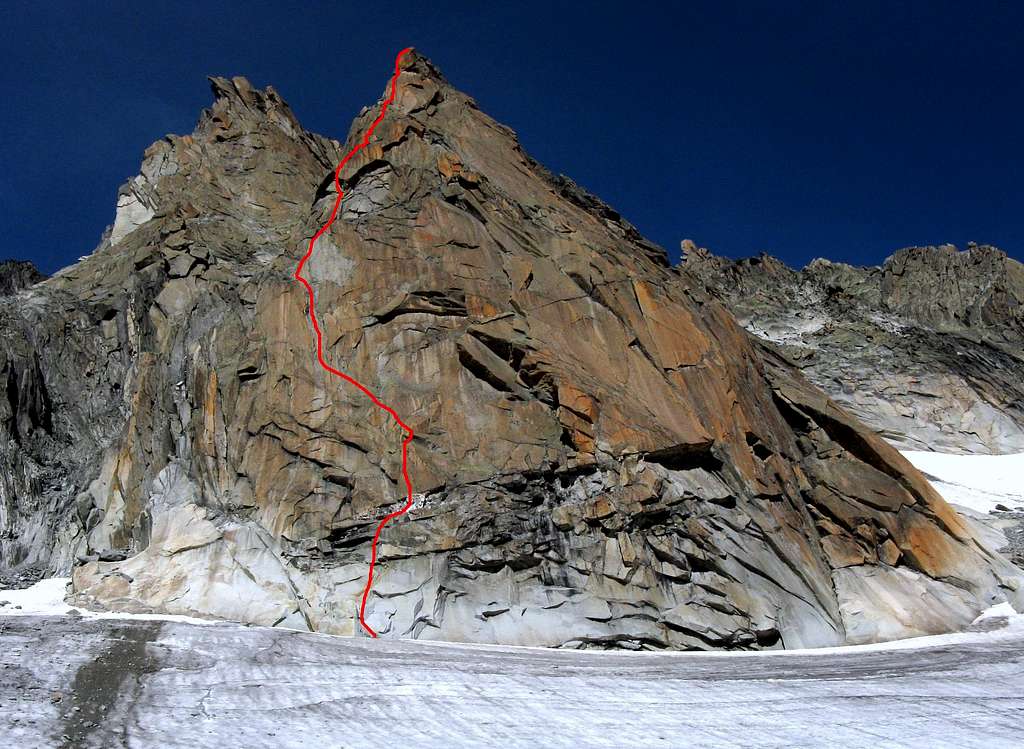
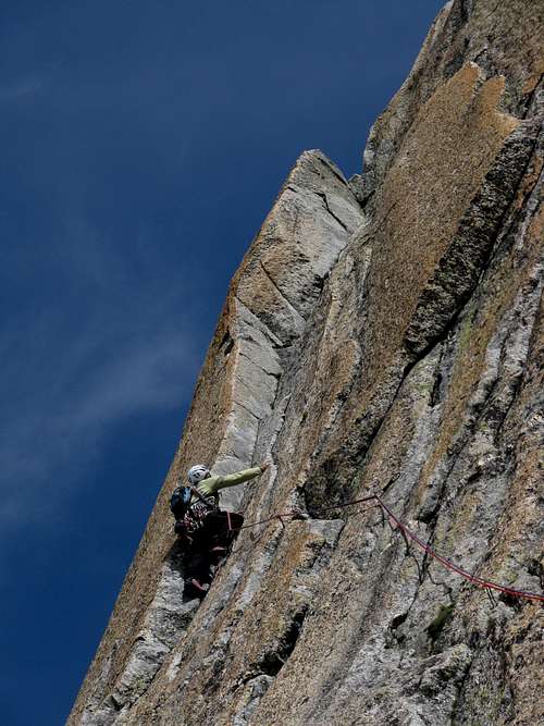
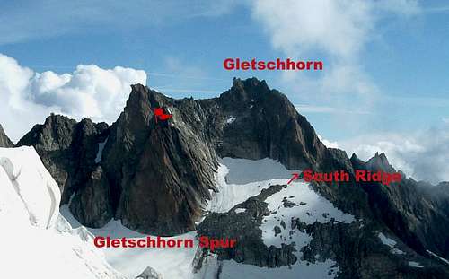
Gletschhorn main summit is an attractive granite peak located on the Gletschorn-Schöllenen ridge. On its left part it shows an obvious reddish spur of first-rate granite, projected to the Tiefengletscher, named Gletschhorn Spur, which has different climbing routes. Amongst these ones, Enfer Doux (Sweet Hell) is a little "pearl” - realized by the Remy brothers in 1985 - running along this fine buttress: you can climb up in a superlative environment on perfect rock. “Enfer doux” reddish granite has surprising intrusion of extra-white quartz. A must!
Getting There
Road Approach
The starting point to climb the Gletschhorn Spur is the Furka Pass road, running from Andermatt, a little town lying at St. Gotthard Tunnel northern exit, to Gletsch. From Andermatt take the road towards the Furkapass, reaching the Hotel Tiefenbach along the same road. A few hundred meters past the hotel take on the right-hand side a gravel toll road and follow it to the Tatsch parking m. 2270 (camping is not allowed).


Red Tape
No particulary restrictions in climbing and hiking. Anyhow, pay attention to these two rules: - Free camping is not allowed in Tatsch - Buy the ticket at the starting of the road towards Tatsch
Enfer Doux report
***Enfer Doux (Gletschhorn Spur)
Spur summit altitude: 3170 m
Difficulty: F5c+
Climbing length: 220 m
Exposure: SW
First ascent: Yves and Claude Remy 1985
Starting point: Tatsch m 2270 (parking)
Hut: Albert Heim Hutte SAC m. 2541
***Enfer Doux report (French Scale)
Quick parties can climb the route in a long day directly from the Tatsch parking. Otherwise it’s also possible to spend the night to the Albert Heim Hutte SAC (Swiss Alpin Club) m. 2541, open in summer. From Tatsch a good trail leads to Albert Heim Hut (one hour); to reach directly the route, at a marked forking don’t follow the trail towards the hut on the right, but continue straight, then head towards left between big blocks, rising along the moraine and reaching a big cairn (“ometto”) near the Tiefengletscher’s beginning. Rising along the glacier towards right, after about 15 minutes of easy walk, an obvious orange spur departing from Gletschhorn summit ridge is clearly visible on your right-hand side (2,15 hours from Tatsch). Enfer Doux starting point is situated below a big white quartz intrusion, on the spur’s left section ; the route on the right is “Little Chamonix” (6b). The route is equipped with spaced bolts. Grades in French Scale.
L1 - Climb a little corner, then easier rocks – visible some big iron pegs, once situated at the starting point, now above, in consequence of the glacier’s strong retreat – to a belay into a curious quartz niche (4a).
L2 – Climb straightly a slab, then slantways toward right, finally a little crack (5c).
L3 – Long slantways toward left to a beautiful corner; climb the corner to its end (5c).

L4 – Towards left go round an edge, climb straight up a slab, then a crack to a stance on a ledge with some blocks. Move towards left along the ledge, reaching a dihedral-crack. Stance below the crack (5a).
L5 – Up along the crack to a little ledge. Belay on the right end of the ledge (5c).
L6 – Up the wall climbing some little cracks, then slantways towards right to a slab. Climb straightly the slab (5a).
L7 – Climb some thin cracks on the right, then a clean crack, ending below the reddish final slab, which leads to the summit of the spur (5c+).
Descent: abseiling along the same route
")
Essential Gear and Climbing Grades
Ropes: 2 x 50 mt., helmet, ten quickdraws. Nut: 4-8 Friends: 1-3 Climbing Grades:
| Rock Climbing Rating Systems | ||||||||
|---|---|---|---|---|---|---|---|---|
| French | YDS (USA) | UIAA | French | YDS(USA) | UIAA | French | YDS(USA) | UIAA |
| 1 | 5.2 | I | 6b | 5.10c | VII- | 7c+ | 5.12d | IX |
| 2 | 5.3 | II | 6b+ | 5.10d | VII | 8a | 5.13a/5.13b | IX+/X- |
| 3 | 5.4 | III | 6c | 5.11a | VII+ | 8a+ | 5.13c | X- |
| 4 | 5.5 | IV | 6c+ | 5.11b | VII+/VIII- | 8b | 5.13d | X |
| 5a | 5.6 | V- | 7a | 5.11c | VIII- | 8b+ | 5.14a | X+ |
| 5b | 5.7 | V/V+ | 7a+ | 5.11d | VIII | 8c | 5.14b | X+/XI- |
| 5c | 5.8 | VI- | 7b | 5.12a | VIII+ | 8c+ | 5.14c | XI- |
| 6a | 5.9 | VI/VI+ | 7b+ | 5.12b | VIII+/IX- | 9a | 5.14d | XI |
| 6a+ | 5.10a/5.10b | VI+/VII- | 7c | 5.12c | IX- | 9a+ | 5.15a | XI+ |
Hut

Albert Heim Hutte 2542 m. - The refuge was built in the year 1918 and called in honour of the Swiss geologist and glaciologist Albert Heim
Owner: SAC Sektion UTO
Size: 64 people
Phone: +41 (0)41 887 17 45
Mail: info@albertheimhuette.ch
Starting point: Tiefenbach (Realp) or parking lot in the "Tätsch" area (toll road).
Albert Heim on Summitpost: Albert Heim Hut
When to climb

Best months are July, August and September
Meteo
Guidebooks and maps


- Guidebooks
- "Schweiz Plaisir Ost" by Sandro von Känel - Edition Filidor 2015
- "Schweiz Plaisir Ost" by Jurg von Känel - Edition Filidor
- Maps
Official Maps of Canton Uri:
CNS - Urseren 1231 1:25.000
CNS - Sustenpass 255 1:50.000