Exploring the south side of the Zillertal Alps

Exploring the south side of the Zillertal Alps

Page Type Page Type: Album
Additional Information Image Type(s): Alpine Climbing, Hiking, Scenery, Panorama, Water

Is this Italy?

The Zillertal Alps span the Austrian-Italian border. That wasn't always the case though; before the end of WW I it was wholly part of Austria. The change didn't mean that the locals suddenly stopped speaking their own language (in most cases local dialects of German), or even remotely started to feel Italian for that matter, but that didn't stop it from happening. But in the following years, the Italian authorities tried to suppress German influences, and one of the measures was to give every feature in the area an Italian name.

These days the suppression is long gone. You hear German everywhere, and if you hear someone using an Italian name for a mountain, you immediately know it's not a local. The official name of the area is Süd-Tirol again, or Alto Adige in Italian. But whenever I go there, it feels more like being in Austria than in Italy to me. Don't get me wrong, I like Italy just as much as Austria. But somehow I keep coming back to Süd-Tirol. And so it happened that I was in the area again in the summer of 2014, armed with a set of maps, my knowledge from previous visits and not much else by way of information. Browsing my maps, I figured that some of the high peaks of the Zillertal Alps might be suitable for solo exploration. I asked around a bit more, which confirmed what I had hoped for, and set off.

Napfspitze (2888m) and the Edelrauthütte (2545m), located on the Eisbruchjoch

  • On the first day I took it easy. I hiked from the Neves Stausee / Lago di Neves to the Edelrauthütte, and, after dropping my pack, made a quick ascent of the Napfspitze / Cima Cadini. It was an easy scramble, but I did need my hands.

  • Approaching the Hochfeiler summit ridge
    Approaching the Hochfeiler summit ridge
    The second day I climbed the highest peak in the group, the Hochfeiler / Gran Pilastro, which was a much longer day. But as I would return to the hut, I only had a day pack, so I could be fast. For the record, I brought crampons and ice axe, and I used them. Without them, the final summit ridge would have been quite tricky. I probably still would have headed up there, but that's easy to say, since I didn't have to make that decision for real.

  • Still a bit tired, I opted for a relaxed third day and scrambled my way up the Hoher Weißzint / Punta Bianca, again as a day trip. The normal route was easy climbing (up to UIAA grade II) and I was enjoying myself. As suggested by the hut warden, I didn't descend the way I had come, but, from the summit, I quickly dropped down to the Gliederferner / Ghiacciaio del Gran Pilastro, west of the mountain, and from there I easily made my way to the Obere Weißzintscharte, where I joined the normal route again. As the warden had said, the descent route was indeed easier - but it does involve a short distance on the glacier (including crossing a small bergschrund) which, depending on the snow cover, can be risky, so it depends on the conditions whether this route is suitable for soloing. If you're in the area and consider doing this, ask the hut warden.

  • Großer Möseler from the SE
    Großer Möseler from the southeast
    The fourth day was a long one again, not least because I was slow, thanks to having to carry all my gear this time. I hiked the Neveser Höhenweg to the Chemnitzerhütte, which by itself isn't a big day, but I tossed in a big side trip to climb the Großer Möseler / Gran Mesule. Since the weather didn't look all too reliable when I started the climb, I didn't drop my big pack but hauled it up with me, with full bivvy gear (including a very warm sleeping bag), so if things turned sour I could hunker down and safely wait until it got better. Fortunately, the bad weather held back, though the clouds left me with very limited summit views. But only minutes after I started down, the sun came back out and stayed with me more or less for the rest of the afternoon.

  • Next morning I was up before dawn, for I had planned one more big day. However, the heavens had opened. It was fortunate that I was in a hut instead of bivvying somewhere, but the rest of my plans where washed out with the rain. But still, I had done a fair bit of exploration. The rest will have to wait for another year.

External Links

History of South Tyrol on wikipedia

Comments

Post a Comment
Viewing: 1-2 of 2
Silvia Mazzani

Silvia Mazzani - Mar 18, 2015 12:34 pm - Voted 10/10
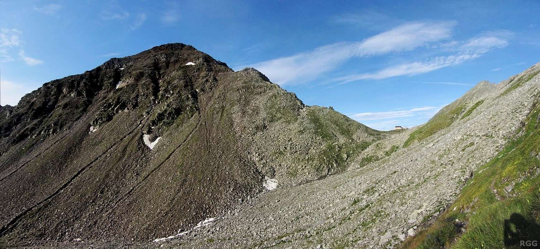
South Tyrol place-names

Hi Rob, often at the end of the wars for someone things do not change for the better. It's the case of South Tyrol or Alto Adige, as you like. At the end of World War I with the defeat of the Austro-Hungarians, the South Tyrol found itself unwillingly to belong to Italy, despite not having anything Italian. No one has yet been able to remedy this unpleasant fact. Although the region enjoys a very wide autonomy, a century has passed and the inhabitants carry on to belong unwillingly to Italy... Unfortunately all the world is full of cases like this! As for the name of the mountains of South Tyrol, I think the best thing is to use both names, the original name and the Italian one. The use of the double name to identify place names in South Tyrol is also important to facilitate the numerous climbers speaking italian who attend these mountains.
Moreover, don't you think that the double name adds a great charm to these beautiful mountains?
Ciao and cheers, Silvia

rgg

rgg - Mar 19, 2015 1:57 am - Hasn't voted

Re: South Tyrol place-names

Hi Silvia,

Not surprisingly, this part of the history of the Alps wasn't taught in school in the Netherlands. Most of what I learned about it was from visiting and from the internet.

Based on what I learned on my visits, by reading the local papers and talking to the locals, I got the distinct impression that if there were a referendum among the inhabitants of South Tyrol about becoming an independent country, it could go either way. In fact, I believe that the majority would like to separate from Italy, and only the uncertainty that that would bring might make people vote against it. Fortunately the whole debate is a peaceful one these days. And it's not like the people in South Tyrol have a problem with the people from the rest of Italy: the main problem they have is with politicians and administrators that try to rule them from Rome. Which, when you think about it, isn't all that different for people from other parts of the country!

As for the names, I'll follow your suggestion and use both of them.

Ciao, Rob

Viewing: 1-2 of 2


Parents 

Parents

Parents refers to a larger category under which an object falls. For example, theAconcagua mountain page has the 'Aconcagua Group' and the 'Seven Summits' asparents and is a parent itself to many routes, photos, and Trip Reports.