Climbing my Namesake - August 8th, 2015
After three long years out west I came home. I spent some time back in Massachusetts, catching up with family and friends, getting (way too) reacquainted with sleeping in, did some freelance jobs for a paycheck, enjoyed the holidays, and turned 30 (that last part really sucked). Around that unfortunate birthday I finally finished my freelance projects and started looking for a job in Jersey so I could move in with my roommate by the time his lease ended in April. Job found and started, my thoughts eventually turned back towards summer and making a trip back west.
My body, which felt great after two plus months of rehabbing a car/pedestrian incident via crippled peakbagging, seemed to collapse shortly after I came home. I threw out my back through merely the act of sleep, my hips, glutes and groin constantly felt like shit, and my body felt creaky as hell even just taking my friends' dog out for an hour long walk. My pedestrian/auto collision in Savannah probably had a bit to do with it, as did my unconventional rehab climbing off the MCL sprain/contusion for the next few months (see the crippled peakbagging TR’s). I really felt the kinks after running for miles with my crutches through the rain and hail across the open fields below Kings Peak trying to escape the lightning, but overall those were but mere building blocks added to years of accumulated everyday shitty and lazy posture at the office and at home (not to mention likely bad form in the weight room).
I belatedly warmed up for my summer trip, mixing in a few Catskills and Hudson Highlands summits with summer drinking and general laziness. Living in a high-rise I have every opportunity to run up the stairs, but found myself only doing so in short phases, more often just resigned to half-assed second rate ellipticalling after the weight room every night. I had my reality check late July after finally making it up to the Adirondacks. A pretty basic day on Algonquin, Wright and Iroquois kicked my ass beyond belief, and my body the next day was stiffer than Roger Goodell during an old fashion self-arbitration session. I had fantasies of getting both Wolfjaw peaks but could only muster enough muscle for the Lower one, and my recovery and soreness felt as if I had never hiked before. My ass had been thoroughly kicked by the ADK’s, and what was worse was that, despite the fact that my legs were complete jelly and, combined with the hip, back and glutes I could barely walk for two days after the weekend, with bad weather and/or various social obligations, this would be my last chance to get my body ready before tackling much tougher peaks out west.
And oh they would be tough. The first week of my trip was to coincide with Greg’s typical August weeklong sojourn, and he managed to wrangle Sam Grant (scgrant on SP along) for the trip by promising him Holland and Snowshoe on the only two days Sam had off from work. Well shit…two fairly difficult Montana peaks meant not much of a honeymoon for me on my return west.
With my only preparation boot shopping at REI with my buddy the weekend before, I started out west Wednesday after work in order to meet the two for Holland by Sunday, taking for the first time the northern route cross country: shitty traffic from Chicago through Rockford, unexpected scenery in Wisconsin, unrelenting rain through Minneapolis, etc. I stopped at an REI in the Twin Cities to stock up on some Gu, feeling anxious about leaving civilization for good and facing the prospect of desolate waste lands for thousands of miles ahead of me, nothing to pass for cities until Billings on the other side of the Plains, or arguably Seattle.
I was a bit delighted to return to North Dakota for the first time since 1994, when my family moved after four years in a state in which I lived for a significant portion of my childhood yet am still not entirely sure actually exists. My day spent there last summer seems a bit strange too, travelling through a land that seemed still stuck in the 90’s. I did stop by Teddy Roosevelt National Park though, taking in the scenic drive and a few short hikes and overlooks before heading to Montana and grabbing dessert at the Beaver Creek Brewery in Wibaux, reaching Billings Friday night to the tune of exorbitant motel room prices due to some state fair going on that weekend.
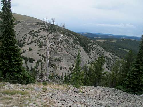
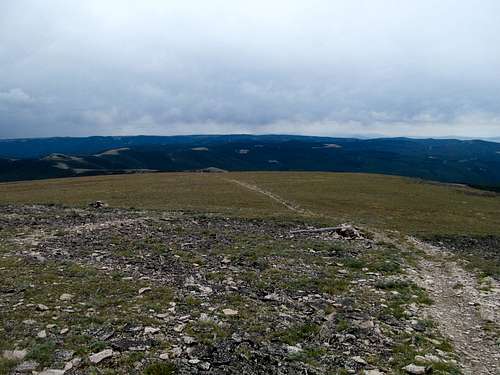
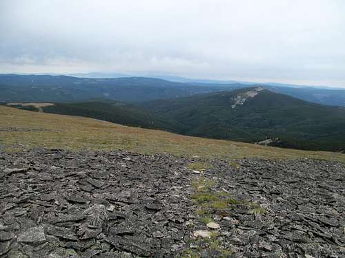
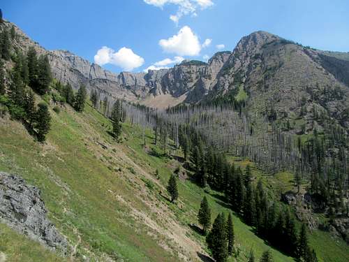
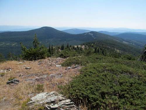
Saturday would be my only chance to warm up, and I picked Big Baldy, the highest point of the Little Belt Range between Helena and Great Falls. I aimed for a rainy start but the morning proved inauspicious as rain pelted my windshield until well after I left the interstate north of Big Timber, the Crazy’s not revealing themselves until I had driven north of them past Harlowtown.
I had to table my original plans for Table Mountain south of Butte for two reasons…I was reasonably behind schedule in terms of driving, and much of the entire state was getting rained and thundered on. Greg, who had headed up from Salt Lake the previous night, would end up passing on the Ruby Benchmark near Dillon due to the downpour (he would get Old Baldy and Black near Ovando instead); he and I both spied better weather the further north we got. I hoped that, with a few extra hours of forecasted breathing room, I had a reasonable shot at getting Big Baldy before the storms were expected to hit later on in the day.
The skies remained cloudy as I rounded US-89 near White Sulphur Springs but never threatening as I drove the moderately bumpy Chamberlain Creek Road which, though suitable for a passenger car, gave me mental goosebumps as I caromed up and down a dirt road for the first time in almost a year. I had marked a pretty major switchback as my starting spot right where the creek came down from the mountain and just before the road took a major turn west. I pulled over and exited the car, breathing the clear mountain air and feeling the anticipation of being back west.
I donned my boots and got right back into the thick of things…literally, making the mistake of starting up just above the creek and finding thick brush to wade through. Things got better as I turned away above the drainage and went up and north through the woods, where the occasional deadfall was much better than the brush down below.
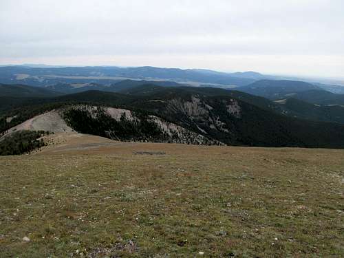
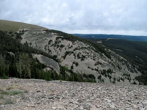
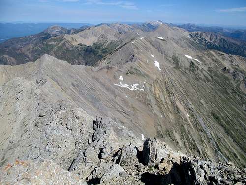
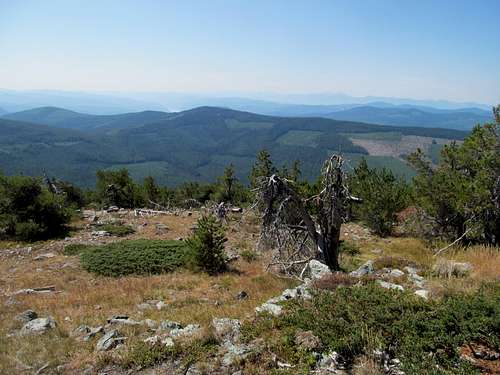
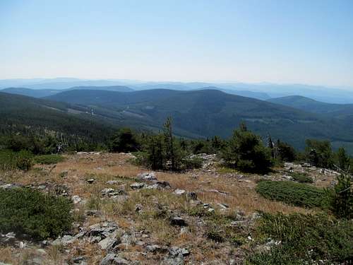
The woods stopped at a small clearing and gave way to a small layer of talus. I felt the familiar crunch of rocks below my boots and tried to take it easy to spare my legs for the coming days ahead. The talus switched back to woods, and I admired the views of Big Baldy visible as I inched along the edge of the Chamberlain Creek drainage until ascending to the ridge crest.
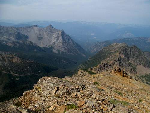
The views opened up to Highwood Baldy and its flunkies to the north sitting under light clouds that were almost almost not cloudy. The winds and thus any storms were coming from the south and west though, and while I saw some wispy clouds coming from those directions, saw nothing serious developing and moving towards me.
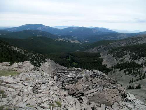
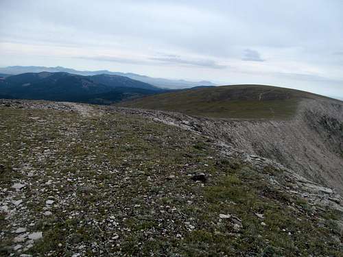
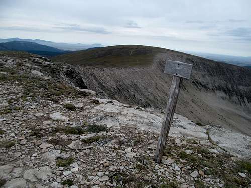
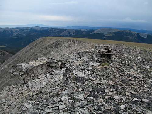
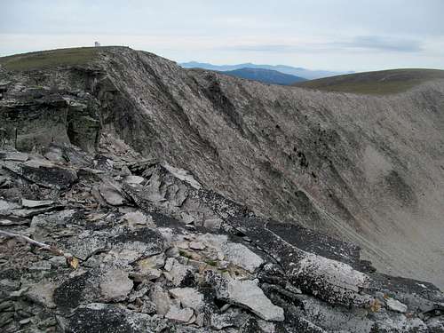
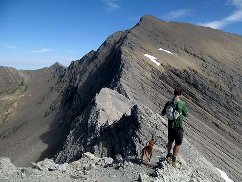
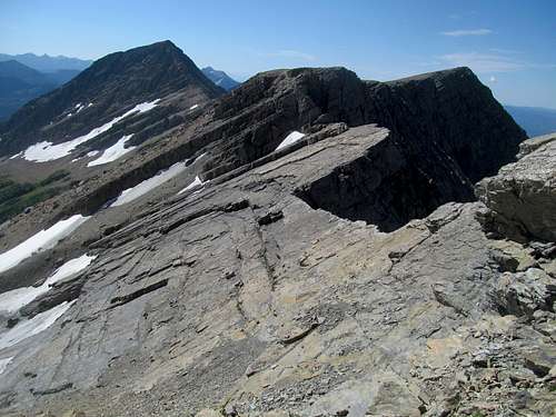
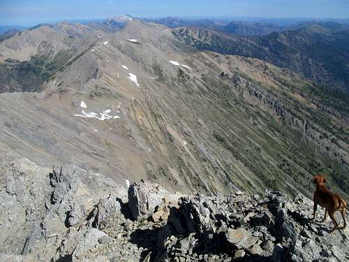
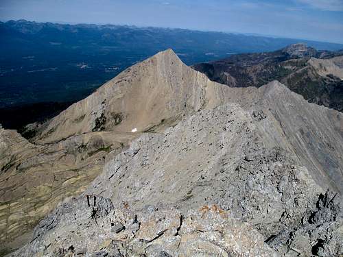
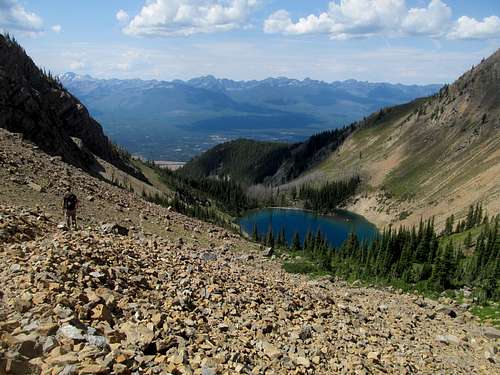
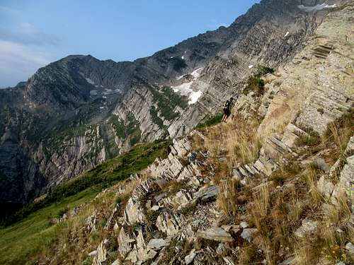
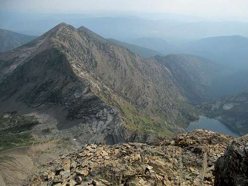
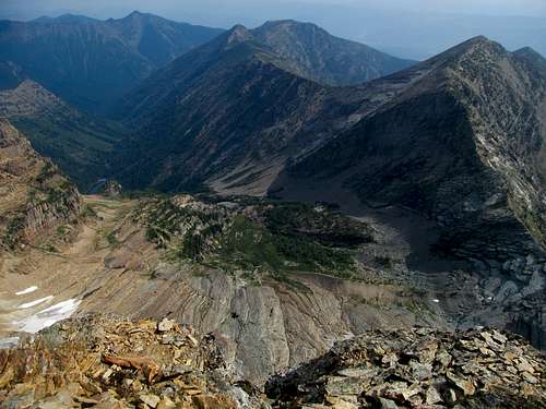
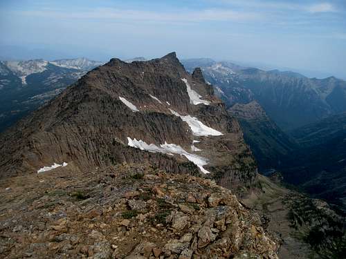
An odd ridge, resembling a man-made reservoir style dam, connected me to the summit of Big Baldy. I found traces of a trail tracing the cool looking rocks on the connector ridge and eventually morphing into an ATV track scarring the west face of the mountain. Not that I was complaining at that moment though, since it gave me what would seem to be a quicker pathway to the summit before the storms developed.
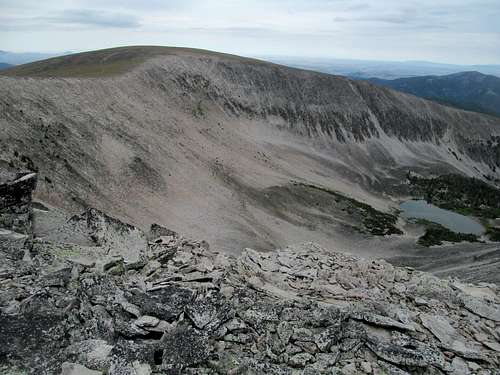
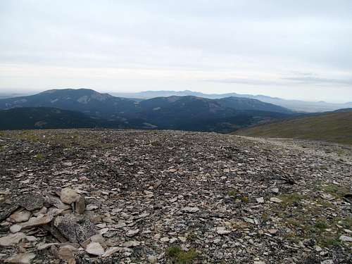
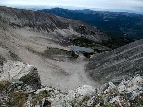
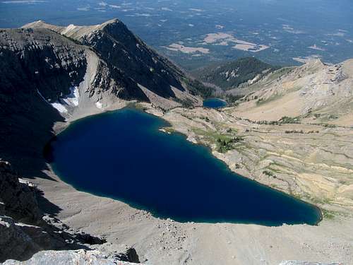
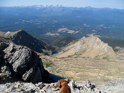
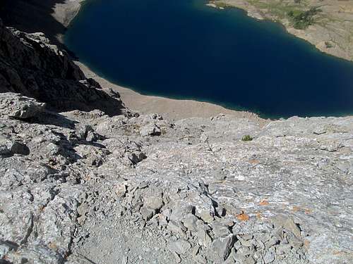
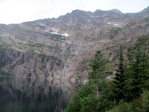
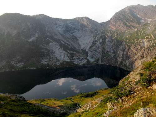
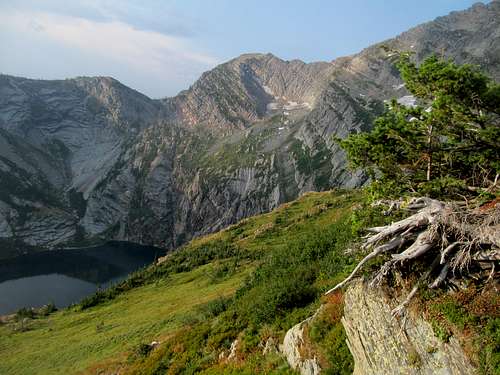
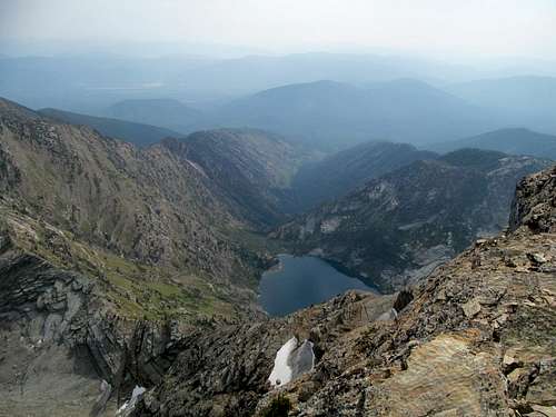
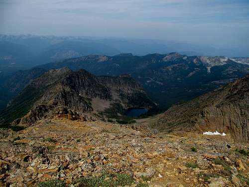
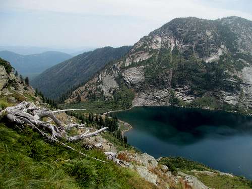
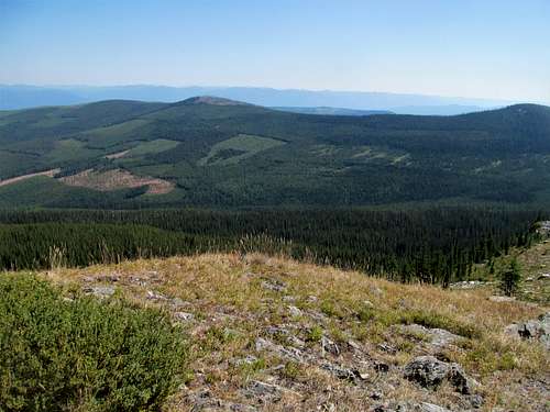
Seeing as a flat summit isn’t much conducive to views, I veered south away from the summit, taking in the vistas before continuing on to the false SE summit, which gave me ample opportunity glimpse each vantage point of Rhoda Lake in the cirque below (a word about the lake…my pictures don’t do it justice…it really is a cool and very obscure/unique looking lake that, whatever you say about it, definitely catches your attention).
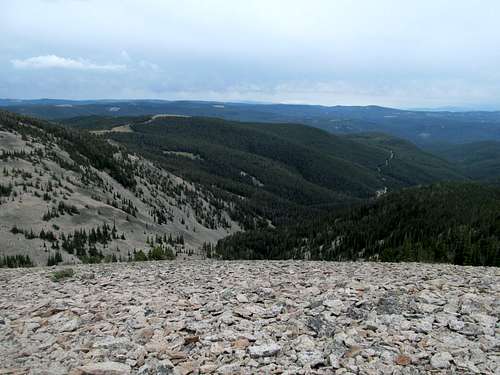
I thought about continuing on to the NE summit for some unobstructed views in those directions but decided against it for two reason: the weather, which had held but held no guarantees going forward, and my need to keep my legs rested for what would be two extremely grueling days ahead.
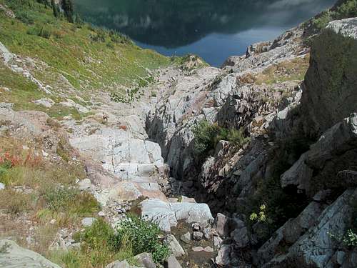
I ambled back down the dirt track and across the connector ridge for the main descent through the graceful looking talus, keeping in mind to not wander too far down the edge of the drainage to my left and the brush I had encountered in the beginning of the hike.
Despite not using GPS (I had lost my old unit in the Adirondacks, bought a new one and yet was too lazy to open/activate it at this point) I managed to my way back to the main road with little difficulty.
Twas a great warm up. I aimed to monitor every twinge of soreness in my body and especially my legs, hoping, no NEEDING for them to stay in mint condition for Holland and Snowshoe the next two days. The weather had held, but my luck would give way as I noticed signs past White Sulphur Springs that US-12 connecting it and Townsend was closed.
What the hell? A major throughway was dead to me, and though I had plenty of time to spare, I hoped to supply up in Helena and relax in a city before meeting up with Greg and Sam (in fact had I really run early I probably would’ve stopped at a brewery in Helena). I drove the highway nevertheless, hoping that if I could drive to even the eastern logging roads to Mt. Edith, I knew from firsthand experience that I could connect over via relatively smooth roads back to US-12 on the Townsend side. Alas, I was shut down, and had to take a lengthy and bumpy ride down dirt roads circumventing the range south of 12, starting with some good if curvy gravel roads, complicated by odd and end forest road junctions made tricky without the benefit of a GPS, and at least rewarded in the end by some nice views of Mt. Edith across the highway as the open ridge descended into Townsend.
Leaving behind memories of the first leg of #crippledpeakbagging from a year ago, I continued through to Helena. There’d be no relaxing at a Barnes & Noble or bar or brewery, but I at least needed to stock up on some supplies, “camping” “food” (Subway…bland but economical and efficient) and finally, some type of liquor to get me through the trip. I stumbled onto a bottle of caramel whiskey on sale whilst looking for cheap scotch and purchased it as fuel for the next two plus weeks.
Greg had reached Seeley Lake well before me, scouted out a good camping spot, and returned to reception to text me and Sam directions to where he’d await us. I felt once more that primal fear as I drove into the unknown, dredging up memories from September 2014 of driving through the Swan Valley sans reception and petrified of not having a clue about what my live and up to date college football scores were at.
I noticed more bars in the small towns like Condon driving through the valley this time around, and felt the pull of these outposts like a siren song. I held firm though, and soon pulled up to Greg and Sam’s campsite. I met Sam, found out he loved beer, made tentative plans to check out a few breweries the next day after Holland, caught up with Greg and Oquirrh, ate my damn sammich and made a dent in my caramel whiskey. My first night back in the truckbed wasn’t all that comfortable and it took me a bit to get to sleep.
Sowing Holland Oats - August 9th, 2015
And so began the real crux of this trip…we all packed up and drove the short gravel road to the Condon Lookout, and I donned my boots and pack with all the anticipation of Tony Eason prior to getting big time smushed by the Bears in Superbowl XX.
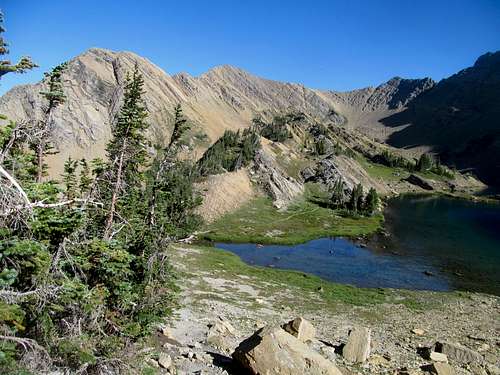
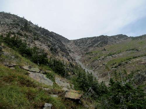
Cedron’s Peakbagging Montana book was accurate as usual; after a gentle first mile we passed the creek crossing and soon spotted the cairn marking the use trail up to the Rumble Creek Lakes, initiating the cardio centric portion of our hike.
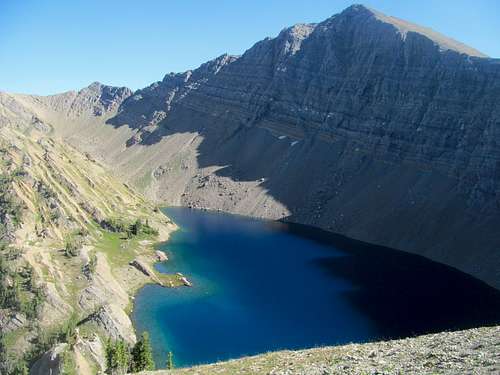
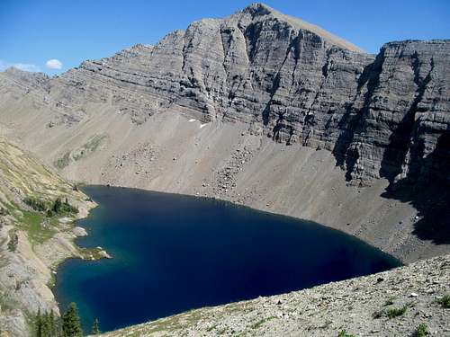
It was obvious that I was in rough shape compared to Greg and Sam seeing as they had not taken close to a year hiatus in peakbagging, but I doubt they enjoyed this steep and occasionally brushy section that much more than I. These two thousand feet up reminded me of Provo Peak in its unrelenting steepness but, though nothing against that Wasatch 11er that tore up my ankle that one time, the payoff for this gain was a bit better as we were rewarded with hashtag views of Holland Peak above tranquil Lower Rumble Creek Lake.
The whole scene seemed almost Colorado-esque for me…while I have learned to neglect the 14er state in exchange for the Idaho/Montana/Wyoming corridor in recent years, the overall spectacular-ness of these northern Rockies are more cozy in nature contrasted against the sheer strength and mass of those lumbering Colorado giants. Occasionally I get glimpses of that sense of awe outside of Colorado, and despite being more than 4000 ft lower and not even falling above 10,000, Holland Peak’s vert impressed.
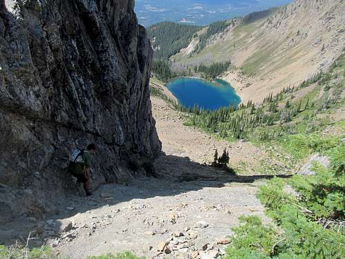
We started up a climbers trail past the Lower Lake, once again beckoning Colorado memories for me, the trail bearing similarities in my memory to those of Pyramid Peak in the Elks or Powell in the Gores. It was steep and loose at times, and get steeper and looser especially near the top of the headwall guarding the upper lake, where traversing left presents you with possibly a more solid scrambly alternative.
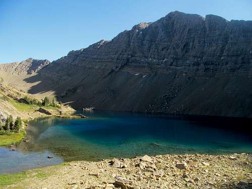
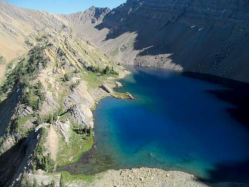
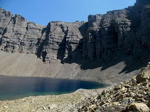
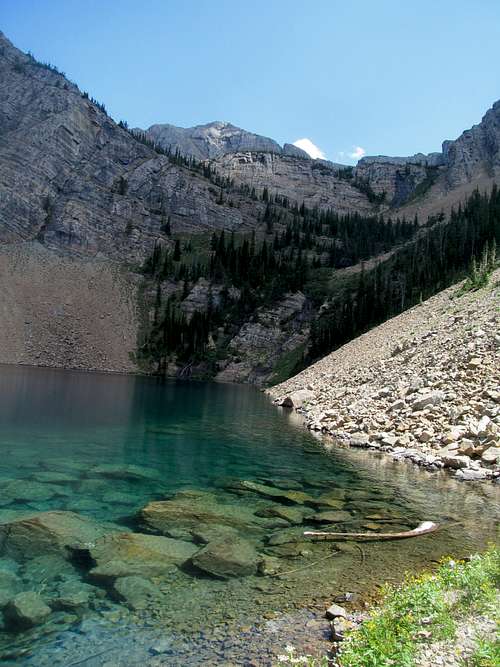
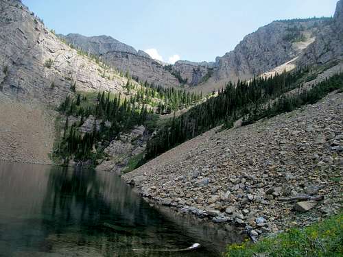
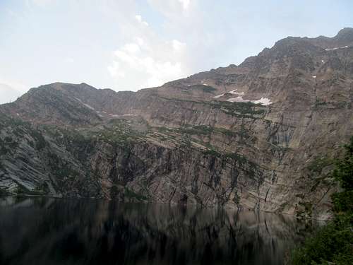
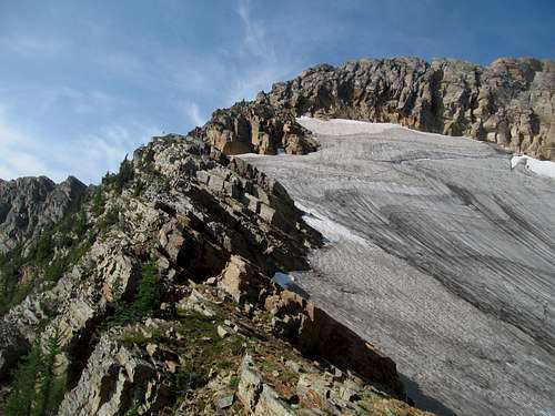
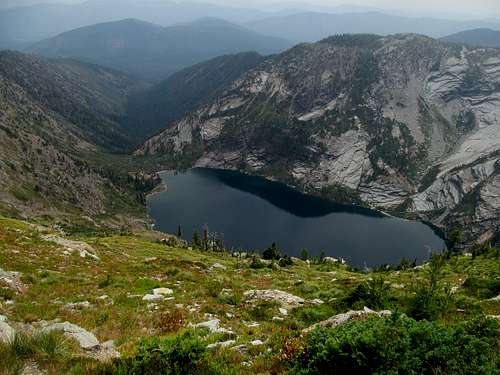
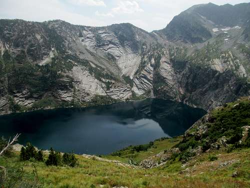
For me, Sam, and even Greg, Upper Rumble Lake was one of the most evocative, unique, and colorful places any of these jaded peakbagging eyes had ever glimpsed.
The incrementally varying shades of turquoise in the lake itself are unlike any other lake any of us had ever been to, the shape perfectly tidy to fully capture your attention from one shore to the other, the scaly rocks holding the water on its western shores a perfectly brilliant juxtaposition to the colors of the waters it guards, and all of this under the watchful , dramatic and raw cliffs of Holland Peak above.
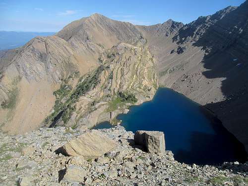
Another steeper, looser and more informal climber’s trail leaves the upper lake, but the suffering is ameliorated with ever changing perspectives of the lake and its surroundings, each unique angle its own masterful narrative.
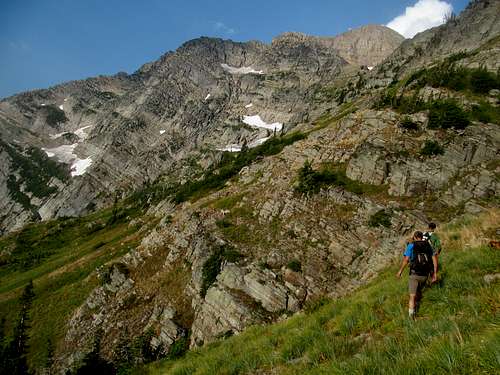
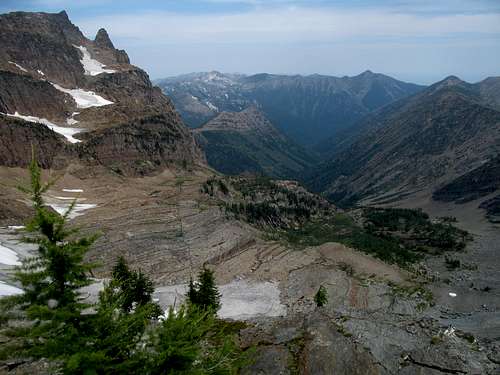
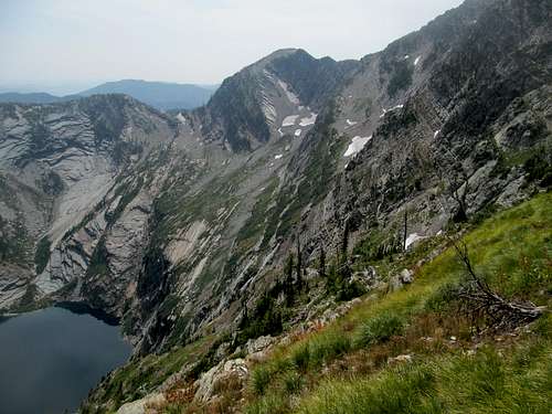
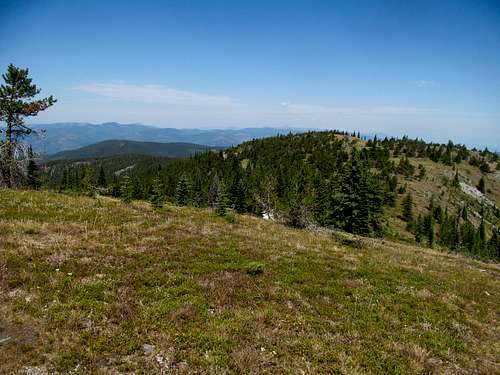
The trail eventually mellows as it ascends a broad face, cresting upon a plateau between Holland and Buck Peak to the south, and giving me my first ever views into the deep and sacred interiors of the Bob Marshall Wilderness.
Once my slow and fat ass caught up to Greg and Sam, we once again set off for the peak.
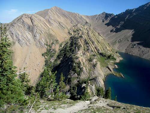
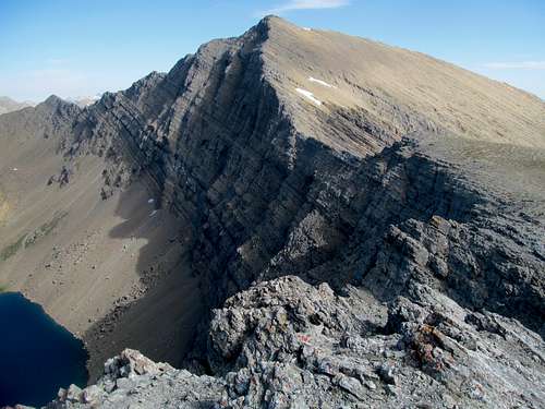
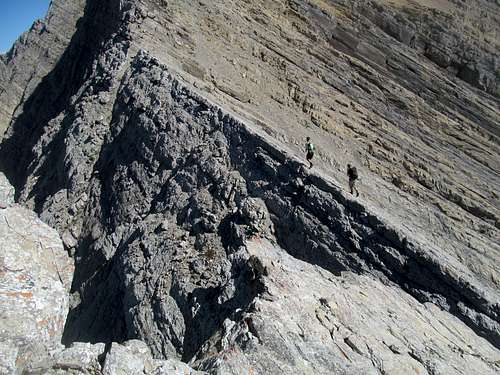
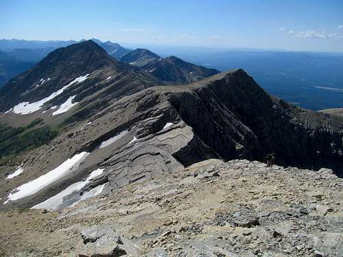
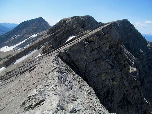
This part proved tricky and a bit scary for me, what with my fear of heights and exposure. First was a downclimb off a knob onto an exposed rocky ridge that I dubbed the chainsaw traverse; Greg and Sam veered right and did what was probably a fifth class downclimb off the knob, while I followed loose ledges left towards the cliffs made a perilous descent that while, probably only class 2, was made more nerve-wracking by the loose scree and rubble on the ledges themselves and the fact that one slip meant I was plunging a thousand feet straight down into the prettiest tableau in the world for a death inducing splatter.
I traversed over and regained the ridge crest for the chainsaw traverse proper. The various knife edges look worse than they actually are, as informal climbers trail make most of the walking class 1, albeit with extreme exposure on your left side, and a sloping, seemingly gentle yet underrated exposure on your right, as that gentle sloping yet consistently angular face looked pretty damn smooth and didn’t end for hundreds and hundreds of feet.
I, being petrified of heights, took it a bit more carefully, while Sam and Greg gracefully clambered their way onto the final smoking lump of the peak itself.
And the last 800 or so feet really sucked, and I clambered behind the group sucking up oxygen from one ledge to the next.
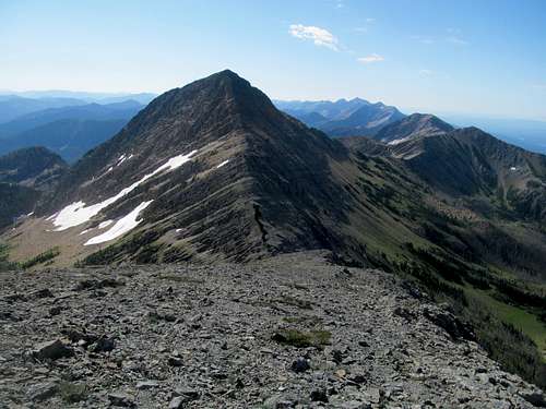
Nothing technical, nothing difficult, nothing scary…just a damn slog and what seemed like a half dozen false summits.
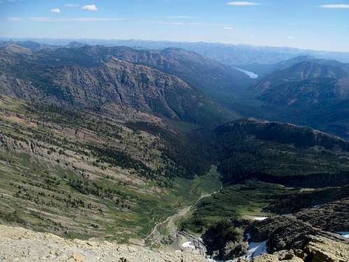
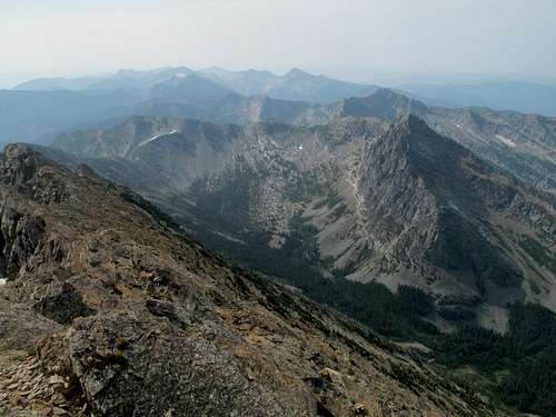
The summit was worth it: vast and endless views of the Bob starting with the multi-colored stretch-marked basin north of Holland. Beyond we tried to make out the jagged peaks of GNP, St. Nicholas especially standing out amongst them. Below us lay the lush Swan Valley and across from it, the noble Missions standing stalwart.
I wandered north to get those views just below the summit ridge, and we dwelled for an extra long time enjoying a snack, chatting and taking in the scene. When it was finally time to descend we did so reluctantly.
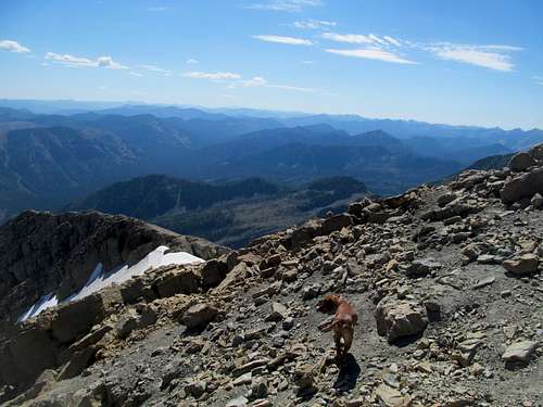
Greg and Sam started down first and I cautiously behind, lagging because I wanted to be extra careful not to fall on loose rock, I’m damn slower on loose rock and talus (much less in general), and I wanted to preserve my legs as much as possible for the ordeal the next day.
We descended back to the chainsaw traverse, and I took my damn time again recrossing it, careful not to fall into bolivian. My legs started to really tire as we descended the mild scrambling and climbers route back down to the upper lake, still as opalescent as ever but now enlightened by the clear, mid-day profile of Holland's sharp west face.
We continued down the steepness to the lower lake, bumping into a group of young hikers from Missoula camping out for the night as well as a couple of old timers/locals who smartly wore microspikes for both the scree and the slippery beargrass.
At the lower lake we rested one last time for the last steep stretch down through what Cedron described as an especially mentally grueling downclimb in the afternoon sun.
Greg was less worried about the sun than the storms, however; Oquirrh had apparently gotten more fearful of thunder and lightning in the past year, and though the skies were clear the forecast promised afternoon storms. In fact Oquirrh did stop at certain spots despite only partly conditions at our spot, and Greg surmised that he heard thunder in far away places incomprehensible to human ears. He trooped on though as the threats were vague, and I felt with each down step the weight of my backpack wearing down my back and shoulders.
My concern were my legs and especially quads, muscles of mine that weaken quickly and dramatically after a long day of steep gain, and while I felt the usual and expected soreness there, my upper torso had stabbed me in the back (no pun intended) and by the time we reached the easy trail my entire back and shoulders were so weak and pained I couldn't even carry my backpack, half dragging it and the trekking poles through the tortuous final mile.
We reached the lot, every single square inch of my muscles were hurting, and I could barely muster the strength to doff my boots and pack back into the 4Runner, collapsing afterwards onto a stump sitting and waiting for Greg and Sam to finish packing up.
My body was hashtag done for sure. I could only try to desperately stretch my legs and consume as much potassium from my inventory of bananas as possible, and throw my own #thotsandprayers my way, hoping I'd be even minimally physically ready for what promised to be a grueling day on Snowshoe Peak tomorrow.
Greg went to the lake to take a swim with Oquirrh while Sam and I headed into sweet friendly civilization in the form of the Flathead Brewing Company, where we lunched on burgers and flights of beer overlooking the brewery's namesake lake, now ominously reflecting darkening clouds above.
We continued on to Kalispell, returning to the scene of the fourth and final doomed leg of my #crippledpeakbagging tour of 2014. Thunder, hail and ferocious winds fought us as we gassed and supplied up for camp that night at a gas station, but the sun was back just a few miles west of town en route to Libby.
We stopped short of the town to hop on the Bear Creek Trail and scoped out the short but rough road to the Leigh Lake Trailhead. Greg had found a small and muddy campspot for the night, but it was enough for all three of us to fit our trucks there.
A Snowshoe Scramble - August 10th, 2015
The campsite was near a creek, adding bugs to the already overbearing humidity. I did my best to try every stretch in the book to get my body ready for Snowshoe, ate my gas station food, Greg cooked, and we all drank and talked more mountains. I got pretty drunk but it was still tough to fall asleep and stay asleep due to the hot and muggy temperatures, and morning found me sleep-deprived and nursing a minor hangover to add to my physical woes.
As a result I headed to the trailhead and got an early start while Greg and Sam packed up their shit. They didn’t linger long and caught me well before the trail got rough near the some sparkling waterfalls below. Typical climbers trail with the easiest of class 2 scrambling, but I could already feel my legs burning and knew that this would be a long day.
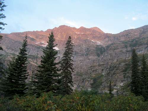
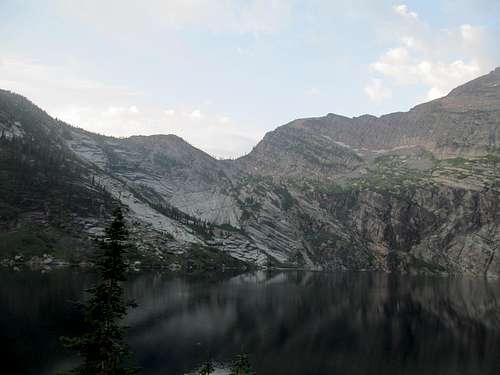
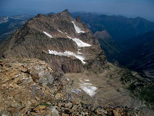
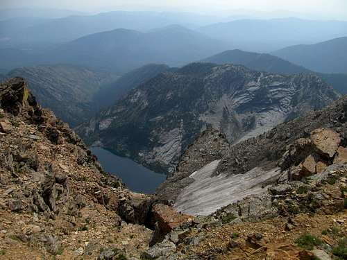
Snowshoe's alpenglowed visage impressed all of us early as did Leigh Lake, which was much larger than I had expected. The lake was ringed by steep granite cliffs on several sides, and from it Snowshoe's east face seemed rise straight from the water to its ultraprominent summit. While Upper Rumble Lake the previous day was a uniquely sublime experience, Leigh Lake here was just as spectacular but in a wholly different way, the cliffs creating setting that was grand, unforgiving, yet intimate.
We walked right along a totes typs narrow and scraggy lakeside trail until it gained a few feet or so disappear in the beargrass slopes just above a lake; there were a couple scattered fisherman and other hikers, one who was ahead of us circumventing the lake but wandered off as we started climbing the peak proper.
I braced my legs for the next steep few thousand feet of climbing ahead as we contoured SW along the face below the Snowshoe-Bockman NE ascent ridge, finding traces of the trail here and there as it seemed to emerged occasionally from a switchback or two only to further disappear back into the beargrass. We found an obvious rock cleft early on marked by rather large squarish boulders and took this opportunity to gain some elevation on good climbing terrain.
We marveled at the full glow of the peak in the morning smog as the alpenglow faded away.
The three of us discussed our options on where we should gain the ridge. I thought we should have been gaining elevation as quickly as possible, as the terrain above us looked reasonable; I would have been wrong, as had we made a beeline for the ridge at that point we would have found ourselves descending back down from Bockman to the saddle through probably slow moving ridge terrain. Greg thought we wanted to get as close to Snowshow as possible, but I had doubts as the terrain closer to the peak looked extremely cliffy. And while I think it did prove a viable route, we took a middle course, as after what seemed like endless repetitive slipping and sliding through sideways beargrass traverses intermingled with easy ledge scrambling on my oh-so-weary thighs, both Sam and I spotted what seemed like a reasonable way up to the ridge.
But we saw a trail about a hundred feet below us leading even further SW towards the peak, and Greg still wanted to test his inclinations, so we split, as Sam and I started up the scrambling to gain the ridge, but not before he and Greg spotted a bear scrambling high up. The funny part was that it was just like us, circling and switchbacking around each turn of the ridge to what looked like slow motion from our perspective, and Sam remarked that us peakbaggers were the only people crazy enough to see a bear in the wild and actually follow it rather than follow its lead and beeline the other way.
While Greg explored his options further down the ridge Sam and I made our way up the ledges and one looser chute that posed some slight difficulty. Greg rejoined us halfway up, having not found his viable route, biting the bullet and we all made one last traversing push through the beargrass to gain the ridge crest below the unforgiving lego blocks of Snowshoe’s east face.
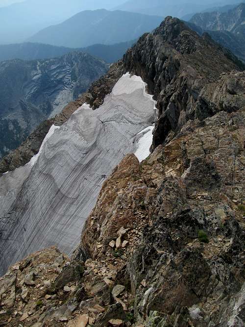
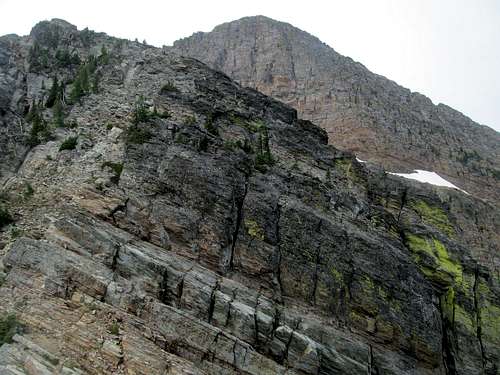
Cedron in his guidebook describes the rest of this route as “never intimidating, just fun.” I was a broken record as I muttered out loud the rest of the way “never fun, just intimidating”, surely to the annoyance of Greg and Sam, though I was rarely within earshot of those two mountain goats. Maybe it was the state of my body, and my continual mental decay into further and further cowardice, but Snowshoe has got to be one of the tougher peaks I have ever done. I’ve been through more challenging cruxes, more exposed terrain, looser, more annoying rock, etc, but never have they all been combined together into almost 4,000 straight sustained feet of challenging climbing and slash or slipping and sliding through the loose beargrass.
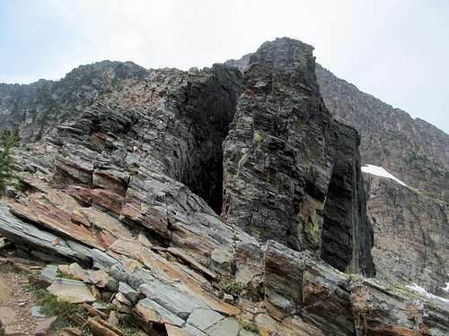
Once on the ridge proper the route was essentially section by section, first past a cleft where we ascended up the lego blocks on the left and passing through dark smoky rocks resembling the ruins of an ancient and abandoned city. Much of the rest of the route was picking through climbers’ trails along the ledgey rocks, scrambling up a small ledge or two, and every so fairly often a steeper class 3-4 face/chimney to climb.
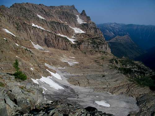
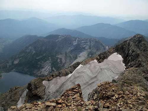
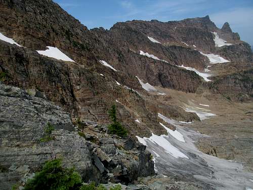
There was eye candy though in the form of the terraced and glaciated A Peak next door, said Blackmore Glacier in between and below us, and the awesome hued granite basin in between us, A, and Snowshoe. This terrain was ain’t nothing like I’ve ever seen, even counting my brief sojourn with Glacier NP, especially considering these oh so unique namesake rocks and faces of the Cabinet Range, though looking at A Peak it could’ve easily been name the Bookshelf or the Library Range. (Or, as I kept joking on the climb, pronouncing it Ca-bin-ney like a hybrid between mountains and a French wine.)
Midway or so between the start of the ridge climbing and the glacier we arrived at a tall chimney requiring several moves to top out. This was the route crux. As usual Greg and Sam waited, probably working on their tan, as I gasped up each climbing step to reach them. Sam started up the chimney, then Greg, who struggled not with himself but with Oquirrh, who was pretty freaked out by the steep chimney. Greg tried to carry and lift him up quite a few times from the lower section and got close a couple times, but Oquirrh refused to connect to solid rock and eventually wriggled away to hide in a small rock alcove at Greg's feet. I thought the terrain if we continued left was promising, with what looked like an open ledge and what could be less difficult ledges, but Greg gave a few more tries before climbing himself up the chimney, hoping Oq would eventually figure it out and follow. I started up the chimney and tried to encourage Oquirrh as I passed him, and he nudged at me a few times as I climbed past him, looking longingly yet helplessly.
The crux chimney required a couple climbing moves on the bottom and the top, with a small lateral move in the middle. Going up it wasn't a huge deal but I was a bit concerned for the down climb. As we continued along the ledge above we saw Oquirrh running back and forth below us, and sure enough he emerged up next to us after a couple minutes, having found a way presumably through the easier terrain left that I had been eyeing.
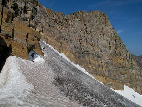
We continued up the same old shit ledge after ledge, climb after climb, and I eyed the expanding glacier up ahead wondering just how steep and difficult it would be.
Greg and Sam had plenty of time to don their crampons waiting for me, and started up the short snow/ice section as I paused to put mine on. I've owned my rusty pair of crampons for maybe five years or so but had only used it probably all of once, which meant that I was totally unfamiliar with exactly how to attach and secure them. I started down a flat but very narrow defile after jumping down from the uneven rocks onto the glacier, but one of the crampons kept falling off. After reattaching it on maybe two separate occasions I reached a slippery step and both came off. Giving up, I made a retreat back across the glacier and decided to try the rock alternative, which turned out to be no cakewalk but pretty basic…certainly no harder than most of the climbing we already had to do to reach it.
With an obvious path and cairns marking a loop left around the backside of the ridge opposite the glacier, I climbed a couple of chimneys that were easier than they looked to rejoin Greg and Sam on the final homestretch ridge. They had been worried, as my travails and tribulations with my equipment and the glacier had taken quite a bit of time, and their calling of my name went unheard by me on the opposite side of the ridge. Undaunted…no, honestly somewhat daunted, and still muttering “never intimidating, just fun”, I followed the two up the final few hundred feet.
This last section was possibly the most annoying of the entire route. The slanted slabby ridges ahead of us seemed endless, and each false summit gave way to higher terrain above it. With more options, the route finding was less straightforward than the more difficult ridge behind us, and several sections that seemed easy resulted in awkward moves to gain the next ledge. We traversed to the left of a high rocky crest, the other side of which contained cliffs leading straight to the glacier.
I finally reached the summit behind Sam and Greg, a small narrow ridge sporting amazing views of the surrounding area despite the increasing haze around us.
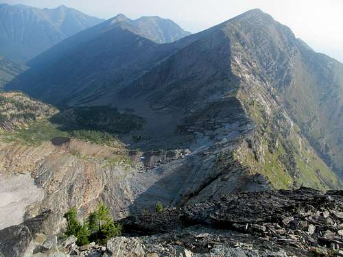
A Peak and the basin below between it, Bockman and Snowshoe had taken up pretty much all of our non climbing attention since first gaining the ridge.
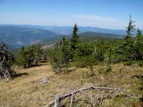
On other directions were vistas down towards Leigh Lake, the slightly less rugged southern Cabinets, and the barely discernable Scotchman and Selkirk Peaks not all that far to the west in Idaho.
We could have sat on the summit eating granola bars for a long time, but being on top isn’t eternal, especially since Sam had to get back to Salt Lake that night. Oquirrh was damn tired too…and probably woke from his long summit nap only begrudgingly to follow us back down the ridge.
I contoured right on my descent down the top ridge, finding easy terrain at first but then more complicated downclimbs that once again slowed down my progress relative to everyone else. The views of the glacier were amazing if more than a bit intimidating, knowing that I’d give the downclimb another chance on the way down. We regrouped at the small perch looking south at the Cabinets between the top ridge and the glacier entrance, and Greg said he’d let me borrow his crampons and descend the glacier whilst he explored the rock alternative; after all, how hard could it be if I had made it through without much trouble?
Greg’s crampons were certainly sturdier than mine, but the initial exit and then descent onto the glacier was extremely steep and the ice extremely hard and slippery. This was much more difficult and treacherous than any snow I had climbed before, and only with Sam’s spotting and coaxing did I managed to descend one small and slow step at a time down to shallower terrain. The thousands of feet of straight hard snow below me, added to the fact that we had decided not to bring an ice axe, made the life and death peril for me as hashtag real as it got, and I immediately wondered how or if I could ever handle the famed Mt. Jefferson of Oregon traverse, which Sam had just recently done and described to us.
After the steep beginning the rest of the glacier descent became progressively easier, and Greg rejoined us at the base having not one issue with the rock alternative. From here, Sam would leave our group as he speed hopped ledge after ledge to hurry his way back to Salt Lake, whilst Greg followed my ponderous speed descending each chimney one careful step at a time.
The downclimb on the crux was interesting. Greg and Oquirrh descended first, and I was more than halfway down when I couldn’t find the next footing and worriedly asked Greg whether this was the right chimney or not. He assured me it was, pointed out the next step, I found it as well as the poles that I had stashed, and the worst was behind us.
The rest of the descent while no joke was mostly manageable, and as we approached the beargrass strewn bottom of the ridge Greg wondered again about a route directly down as an alternative to our slippery traverse.
Despite the occasional sighting of a trail below us we stuck to our original course, descending the same series of ledges that had initially led us up to the ridge. I continued down while Greg searched the beargrass bushes fruitlessly for a rather expensive collar that Oquirrh had lost while tangling with the brush on the way up.
Just like the previous day on Holland the rest of the descent was a trudge of hellish proportions mentally and physically, as every muscle hurt almost as bad (though surprisingly not worse) than the day before. We descending through the last series of ledges and fought past the narrow and brushy trail lining Leigh Lake and the short but steep march back to the parking lot.
I felt little sense of accomplishment sitting by my car, only exhaustion and a sordid summer sun continuing its relentless barrage. Greg and I chatted for awhile and he fixed my long-broken blinker light in between. Then he continued on into Idaho to go after South Selkirk Crest and Saddle; I had initially imagined the former after Holland and Snowshoe as a rest day but realistically knew now that I needed more than my share of easy recovery days.
McGuire Chillax - August 11th, 2015
I drove into Libby for my long awaited shower and motel time, stopping by the new Cabinet Mountain Brewery in town where I enjoyed their selection of beers, which included a hopless spruce beer as well as the best potato salad (Bavarian style) I’ve ever tasted.
This past summer I returned to Libby for a night and found out that their bars don’t stay open all that late. After Snowshoe I was so tired I never even bothered to discover this fact, instead downloading the season finale for the recently concluded True Detective Season 2, despising the ending, and falling asleep on those terms.
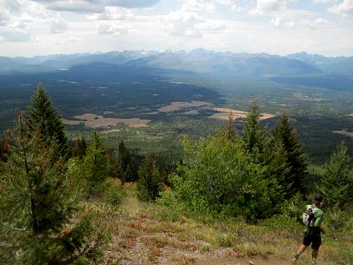
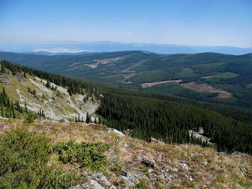
I chose to sleep in but twasn’t a big deal as my goal for Tuesday was McGuire, the small highpoint for the surprisingly expansive Salish Range whose summit lookout is reached via a very short and easy hike after over an hour of windy driving on miles and miles of rather good road. I got my first taste of Lake Koocanusa, the border crossing reservoir that was scenic but a drag to drive around. Above it towered nameless wooded peaks that do probably have names that I simply was too ignant to know.
The ten miles or so of dirt roads leading to the trailhead were more than suitable for passenger cars as long as you watched the switchbacks and the trail, similar to many peaks in this area I could compare only to Ch-paa-qn based on prior experience: wooded, easy grades, and rather boring after a few initial open stretches through fields with a few light blue rock patches and a couple spots where you could see northeast along the ridge.
The views opened up once atop the ridge as the trail rounded the northern summit, and I enjoyed vistas of Nausokoin and the Whitefish Range whilst descending the small saddle north of the true summit and lookout.
A lady had rented the lookout and was chilling so I said hi and gave her her space, wandering south to take pictures of the very hazy Cabinets to the south and barely glimpsing the serrated peaks of Glacier National Park. The combination of haze, tree-lined hills, and clearcuts made the rest of the views rather dull, and I didn’t linger too long before heading down.
My legs muscles were still wasted but McGuire did nothing to worsen the sitch, which is all I could ask for. I made a return visit for lunch (more potato salad!) at the Cabinet Brewery, then continued to Bonners Ferry. Rest was still on my mind, but a bit more recovered from Holland and Snowshoe I spent the evening sampling the beers at the Kootenai Brewing Company and the night chatting with the locals at Mugsy’s, the local tavern and the only one in town willing to stay open after dark.
Comments
No comments posted yet.