-
 12062 Hits
-
 76.66% Score
-
 7 Votes
|
|
Route |
|---|---|
|
|
49.18373°N / 20.08781°E |
|
|
Hike + Scramble |
|
|
Most of a day |
|
|
0 ,crumbly walk-up |
|
|
Approach
Palenica Bialczanska - Morskie Oko - 9 km walk (tourist road)
Route Description
Starting at Morskie Oko Chalet(1405) follow red marks.The trail goes along eastern shores of Morskie Oko lake ,then climbs the steep threshold of Czarny Staw Pod Rysami(1562) (Black Lake). Gorgeous high mountain scenery of the giant post-glacial pot hole.
Next we go along northern and eastern shore of the lake to the south. At the point at SE shore our path crosses wide, scree couloir and climbs in zigzaks by quite steep grass-rocky slope. Then it leads by grassfields on the right just below cliffy rocks of Bula Pod Rysami to great couloir between Niznie Rysy massif(left) and Wolowy Grzbiet(right). Crossing a stream the path climbs in rocky terrain till it reaches huge screefields sloping down west from Rysy ridge in the close neighbourhood of well seen just ahead serious rocky perch by which the red marked Rysy trail continues its run.
Right to the perch we can see the mouth of famous, characteristic “rysa” (“scratch”) couloir falling down from the Rysy summit (usually filled with snow). The flat grass-rocky space behind us below is so called Bula Pod Rysami(2055).
We are at the height of about 2150 m asl . (2 ½ h from Morskie Oko).
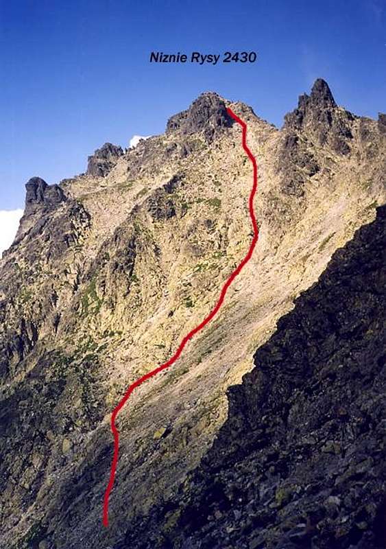
150 meters before the perch we turn left off the marked trail onto huge scree slope spreading out to the east ,left to the Rysy’s perch. Last water. Our route climbs now the slope, it is better to choose the left side due to horribly crumbly conditions of the exhausting walk-up.
Finally turning left we enter a wide ,hollow, scree couloir falling down from a little saddle between the main and the south summit of Niznie Rysy.
After reaching the saddle we climb quite easily to the summit by the ridge or huge rocks just below .(about 3 1/2 hours in good summer conditions).
The Niznie Rysy summit route was first marked blue in 1908 by Towarzystwo Tatrzanskie (Polish Tatra Company) ,but marks weren’t renewed.

Niznie Rysy from south-west , classic route
Essential Gear
In summer : mountain tourist equipment ,good hiking boots and waterproofs ...In winter when there is no avalanche danger : at least ice-axe and crampons + experience in climbing huge steep snowfields .
Watch out ! After heavy rains the whole area is seriously endangered with rocky avalanches !

