
-
 6846 Hits
-
 83.1% Score
-
 16 Votes
|
|
Mountain/Rock |
|---|---|
|
|
43.21304°N / 5.46640°E |
|
|
Bouches du Rhone |
|
|
Trad Climbing, Sport Climbing |
|
|
Spring, Fall, Winter |
|
|
1526 ft / 465 m |
|
|
Overview
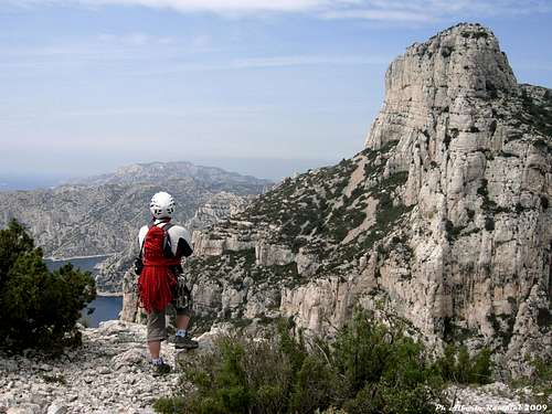
Grande Candelle 465 m
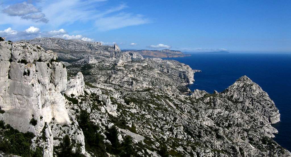
Between Marseille and Cassis the Mediterranean coast forms one of the most beautiful limestone massif of the world, wild and well preserved despite being close to civilization: the Calanques of Marseille. A truly magical place to play many outdoor activities, including hiking and climbing. The white limestone of the Calanques overlooks narrow fjords and blue and turquoise sea with unmatched aesthetics and offers unforgettable sensations. Grande Candelle is a secluded stone-sentinel in the heart of the Calanque de Sugiton, a true summit offering exciting climbing routes and spectacular scenery. It's the symbol of climbing in the Calanques, suspended in the sky between land and sea, a unique place in the world. Although not Calanques highest peak - that is in fact Mont Puget - Grande Candelle has always been regarded as the summit par excellence of the Calanques. The climb is extremely varied on slabs, chimneys and cracks and the rock quality is excellent. Definitely a place not to be missed, as well as the great classic of the mountain, Arête de Marseille, so named in reason of its orientation towards Marseille (West) and opposed to an other longer ridge facing East, the Arête de Cassis.
Getting There
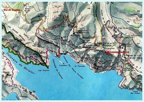
It will be described the approach from the town of Cassis, located to the East of Marseille.


Road Access
From Cassis take the road D559 towards West. After crossing the Col de Gineste, the road descends to the East end of Marseille. At the first roundabout leave the main road to Marseille and turn to left to Luminy. Parking lot.
Approach path
From the University of Luminy take the wide path to Col de Sugiton, reaching the Col de Sugiton. Continue on the path n. 6 green and yellow marked and once getting to a plateau leave the main path and take a level track toward East, leading to the base of the Couloir du Candellon,the access to the Grande Candelle. Climb up the steep couloir for about 100 meters with some climbing and exit to the right (old black marks). Across a scree traverse right under the South wall of the Grande Candelle. On the left edge of the wall it starts the classic Arête de Marseille. The approach to the other routes running on South wall is done skirting the same wall.
Arête de Marseille description

Arête de Marseille
Difficulty: D+, 5c max
Length: 150 m.
Pitches: 6
Exposure: W
Apart the first pitch, become absolutely slippery because of the attendance, it's a fun and pleasant climb up a ridge with good rock. From the summit there are great views over the Calanques. Start below a chimney-crack.
Route description
L1 - A difficult chimney-crack especially in reason of the smooth rock due to the high attending. Climb the chimney-crack, keeping the left slab. Climb a small corner on the left to reach the notch between the left spire and the main ridge and belay a little below the summit of the spire, 5c 40m.
L2 - With a broad airy move cross from the gendarme to take the main ridge; once you reach the ridge climb at first a little wall on the left, then the edge of the ridge, 5a 30m
L3 - Continue on the edge of the ridge, 4a, 55m possibility to divide the pitch in two ones.
L4 - Climb a wall leading to the final ridge 4c, 35m
L5 - Up easily to reach another short wall
L6 - Climb directly the wall 5c, 5 m, getting to the beautiful summit.


Descent: along the North wall. Follow the cairns on the summit ridge towards East, then some ledges along the North side for about 80 meters. On the left below the top it's located an abseil anchor, another one is located further left. A 35 meters abseil leads to the bottom. A path towards West reachs the Col de la Candelle, from where the green path and GR lead to Luminy.
Essential gear
Ropes 2 x 55, helmet, some quickdraws
Other routes
South face main routes:
- La Cheminee
- La Centrale
- Super Centrale
- Le Couloir Suspendu
- Arête de Cassis - Another classic route running on the East ridge, opposite to the Arête de Marseille
Red Tape
Grande Candelle is situated inside the Calanques National Park; the climate is dry and the winds may sometimes be violent, with a high risk of fires. Starting from June to the end of September the roads leading to the bays of Sormiou, Morgioux and Callelongue are closed from 7h to 19h. Check the park official website to know the prohibitions and permissions for the access during the summer months: Calanques National Park
When to climb
All year round excluding the summer really too hot and with various access restrictions as said at the previous chapter. An excellent advice for planning a climbing trip: the best season goes from October to May.
Where to stay
A great place to stay is the little town of Cassis with wide possibility of accomodation, including a good campsite:
Camping Les Cigales Avenue de la Marne - Cassis Phone 00330442010734
Meteo
Guidebooks and maps
“Escalade Les Calanques” by Andrè Bernard - Gilles Bernard - Pierre Clarac – Hervè Guigliarelli – Bernard Privat Ed. Nota Bene
"Alpes du Sud - Provence" by Hervé Galley - Editions Olizane
“Calanques Escalade” by Jean Luois Fenouil and Cèdric Tassan – Ed. VTopo
Map: "Les Calanques de Marseille a Cassis" 3615 IGN 1:15.000